
Looking at the WV imagery there is a huge anticyclone building with convection popping near the center.
Typical scenario with a developing storm moving WNW is a gradual curve to the right as a deep storm is steered by the anticyclone. But none of the models show this and there were some digging troughs that might erode the ridging (if the dome even develops).
We will probably see at least one model run that shows a deeper system curving north into the western gulf then NNE.
ATL: GAMMA - Post-Tropical - Discussion
Moderator: S2k Moderators
Re: ATL: INVEST 91L - Discussion
2 likes
-
wxman57

- Moderator-Pro Met

- Posts: 23174
- Age: 68
- Joined: Sat Jun 21, 2003 8:06 pm
- Location: Houston, TX (southwest)
Re: ATL: INVEST 91L - Discussion
Models indicate a ridge building over TX and LA next week. That would keep the system from coming northward. Lots of shear and dry air across the northern Gulf, too.
2 likes
-
eastcoastFL

- Category 5

- Posts: 3996
- Age: 44
- Joined: Thu Apr 12, 2007 12:29 pm
- Location: Palm City, FL
Re: ATL: INVEST 91L - Discussion
jlauderdal wrote:THere is a flash flood watch through Sunday night...whenw as the last time you saw one issued for 72h...the stalled front is responsible, not the tropics although some moisture and energy may make it from the current system but really it will have minmail effect.Miami Storm Tracker wrote:Is high pressure that strong that is steers this that far west? With the cool front draped across Florida you would think a ENE or NE direction would be there. Our local weather forecast is for 4 to 6 inches of rain. That will not happen if this get pushed further west.
I got that alert this morning and was wondering what the source was as it hadn’t even rained yet then I got a flash flood warning that expires at 8pm tonight but the watch remains for the weekend
0 likes
Personal Forecast Disclaimer:
The posts in this forum are NOT official forecast and should not be used as such. They are just the opinion of the poster and may or may not be backed by sound meteorological data. They are NOT endorsed by any professional institution or storm2k.org. For official information, please refer to the NHC and NWS products.
The posts in this forum are NOT official forecast and should not be used as such. They are just the opinion of the poster and may or may not be backed by sound meteorological data. They are NOT endorsed by any professional institution or storm2k.org. For official information, please refer to the NHC and NWS products.
-
eastcoastFL
- Category 5
- Posts: 3996
- Age: 44
- Joined: Thu Apr 12, 2007 12:29 pm
- Location: Palm City, FL
Re: ATL: INVEST 91L - Discussion
wxman57 wrote:Models indicate a ridge building over TX and LA next week. That would keep the system from coming northward. Lots of shear and dry air across the northern Gulf, too.
Is shear forecast to remain over the entire gulf in the next 3 days ? If it somehow makes a move to the NE is shear and dry air forecast to be towards Florida?
0 likes
Personal Forecast Disclaimer:
The posts in this forum are NOT official forecast and should not be used as such. They are just the opinion of the poster and may or may not be backed by sound meteorological data. They are NOT endorsed by any professional institution or storm2k.org. For official information, please refer to the NHC and NWS products.
The posts in this forum are NOT official forecast and should not be used as such. They are just the opinion of the poster and may or may not be backed by sound meteorological data. They are NOT endorsed by any professional institution or storm2k.org. For official information, please refer to the NHC and NWS products.
-
eastcoastFL
- Category 5
- Posts: 3996
- Age: 44
- Joined: Thu Apr 12, 2007 12:29 pm
- Location: Palm City, FL
Re: ATL: INVEST 91L - Discussion
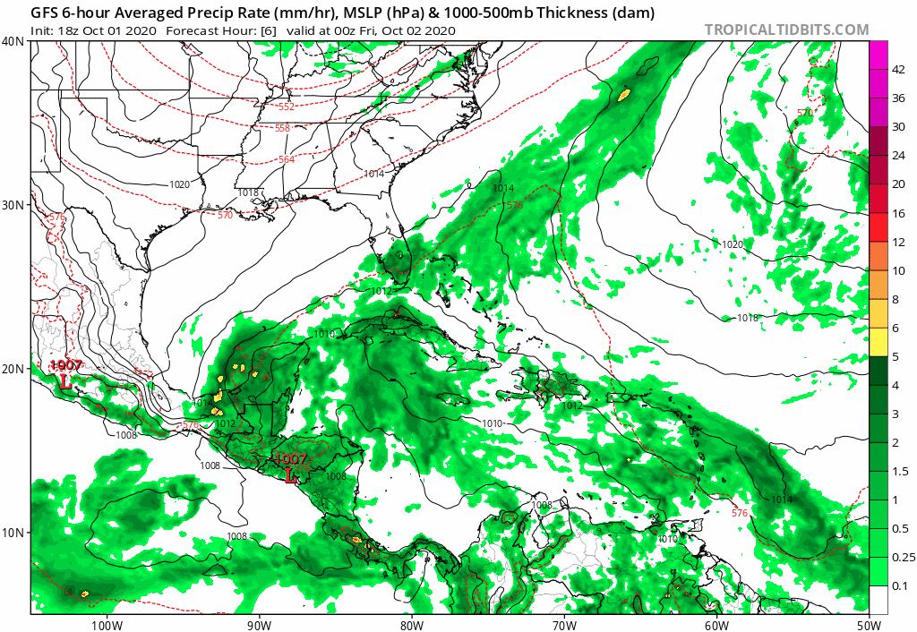
gatorcane wrote:18Z GFS stronger and buries in the BOC. Odd pattern as the storm gets north of the Yucatan and still goes SW:
https://i.postimg.cc/59Y0Mk7r/gfs-mslp-pcpn-watl-fh6-150.gif
So the low moves sw yet most of its energy separates and heads north east? What’s the reason for that?
0 likes
Personal Forecast Disclaimer:
The posts in this forum are NOT official forecast and should not be used as such. They are just the opinion of the poster and may or may not be backed by sound meteorological data. They are NOT endorsed by any professional institution or storm2k.org. For official information, please refer to the NHC and NWS products.
The posts in this forum are NOT official forecast and should not be used as such. They are just the opinion of the poster and may or may not be backed by sound meteorological data. They are NOT endorsed by any professional institution or storm2k.org. For official information, please refer to the NHC and NWS products.
-
cycloneye

- Admin

- Posts: 149442
- Age: 69
- Joined: Thu Oct 10, 2002 10:54 am
- Location: San Juan, Puerto Rico
Re: ATL: INVEST 91L - Discussion
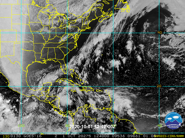
A broad area of low pressure has developed over the west-central
Caribbean Sea just north of the northeastern coast of Honduras.
Satellite images indicate that showers and thunderstorms are slowly
becoming better organized, and a NOAA buoy northeast of the center
has reported winds to near tropical storm force during the past few
hours. Environmental conditions are expected to be conducive for a
tropical depression or a tropical storm to form on Friday or
Saturday, but only if the system moves and remains over the waters
of the northwestern Caribbean Sea or southern Gulf of Mexico.
Development will become less likely if the system moves over the
Yucatan Peninsula or northern Central America. Regardless of
development, this system is expected to produce locally heavy rains,
with possible flash flooding, over portions of southeastern Mexico,
Central America, and western Cuba during the next several days, and
interests in those areas should monitor the progress of this
disturbance. An Air Force Reserve reconnaissance aircraft is
scheduled to investigate the system tomorrow afternoon, if
necessary.
* Formation chance through 48 hours...high...70 percent.
* Formation chance through 5 days...high...80 percent.
0 likes
Visit the Caribbean-Central America Weather Thread where you can find at first post web cams,radars
and observations from Caribbean basin members Click Here
and observations from Caribbean basin members Click Here
-
cp79
Re: ATL: INVEST 91L - Discussion
eastcoastFL wrote:gatorcane wrote:18Z GFS stronger and buries in the BOC. Odd pattern as the storm gets north of the Yucatan and still goes SW:
https://i.postimg.cc/59Y0Mk7r/gfs-mslp-pcpn-watl-fh6-150.gif
So the low moves sw yet most of its energy separates and heads north east? What’s the reason for that?
I just think it’s shear. Fla west coast prolly gonna get a lot of rain from this even if the low moves the other way.
0 likes
-
Miami Storm Tracker

- Category 4

- Posts: 916
- Age: 68
- Joined: Sun Jun 13, 2010 10:12 pm
- Location: Key Largo, Fla.
- Contact:
Re: ATL: INVEST 91L - Discussion
Had a very heavy slow moving thunder storm blow through the Westchester area couple of hours ago here in Miami.
2 likes

Re: ATL: INVEST 91L - Discussion
I think this should be designated as a PTC tonight because of its high 48hr development chances and upcoming threats to Central America, primarily the Yucatán Peninsula, where it could be stuck over or near for several days.
0 likes
Irene '11 Sandy '12 Hermine '16 5/15/2018 Derecho Fay '20 Isaias '20 Elsa '21 Henri '21 Ida '21
I am only a meteorology enthusiast who knows a decent amount about tropical cyclones. Look to the professional mets, the NHC, or your local weather office for the best information.
I am only a meteorology enthusiast who knows a decent amount about tropical cyclones. Look to the professional mets, the NHC, or your local weather office for the best information.

-
lrak

- S2K Supporter

- Posts: 1770
- Age: 59
- Joined: Thu Jun 21, 2007 2:48 pm
- Location: Corpus Christi, TX
Re: ATL: INVEST 91L - Discussion
Off the NE coast of Honduras looks strong tonight. The last visible satellite images were spinning at the LLs which Nimbus explained.
0 likes
AKA karl
Also
Personal Forecast Disclaimer:
My posts on this forum are NOT official forecast and should not be used as such. My posts are my basic observations and are definitely not backed by any "well some" meteorological knowledge. For official information, please refer to the NHC and NWS products.
Also
Personal Forecast Disclaimer:
My posts on this forum are NOT official forecast and should not be used as such. My posts are my basic observations and are definitely not backed by any "well some" meteorological knowledge. For official information, please refer to the NHC and NWS products.
-
gatorcane

- S2K Supporter
- Posts: 23708
- Age: 48
- Joined: Sun Mar 13, 2005 3:54 pm
- Location: Boca Raton, FL
Re: ATL: INVEST 91L - Discussion
Looks to be organizing. Really quiet in the forum here (for a developing TC in the NW Carib) because it doesn’t look to be a threat to the GOM coast or Florida.
2 likes

Re: ATL: INVEST 91L - Discussion
NHC notes that this is already producing nearly TS force winds.
Could skip depression status and go straight to TS Gamma.
Could skip depression status and go straight to TS Gamma.
2 likes
-
gatorcane
- S2K Supporter
- Posts: 23708
- Age: 48
- Joined: Sun Mar 13, 2005 3:54 pm
- Location: Boca Raton, FL
Re: ATL: INVEST 91L - Discussion
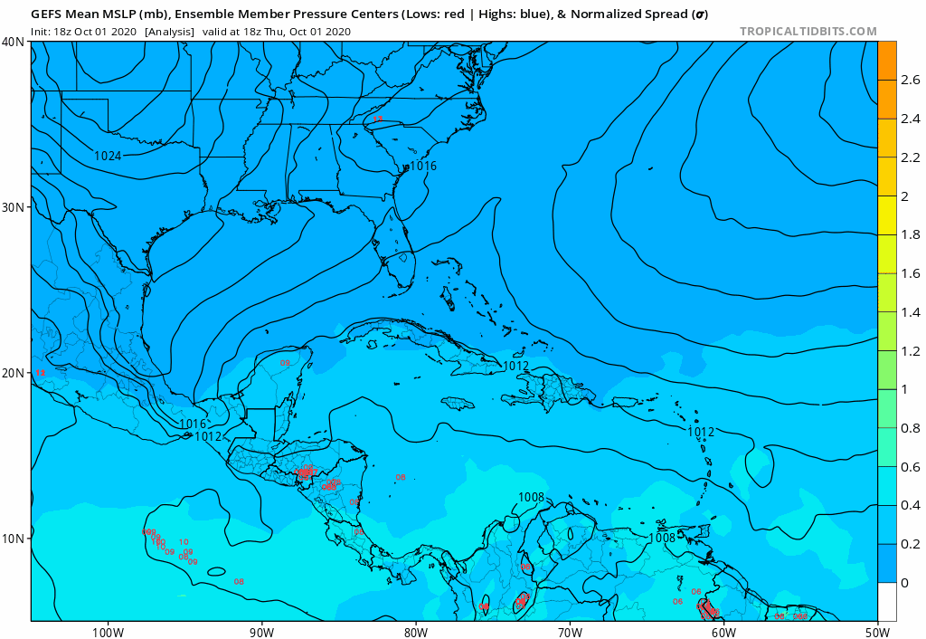
Watch how the GEFS tracks have this putting on the brakes as they head towards Florida where they turn west away. 
0 likes
-
NevadaFan18
- Tropical Depression

- Posts: 51
- Joined: Fri Aug 21, 2020 1:51 pm
Re: ATL: INVEST 91L - Discussion
With the way it’s looking right now, on the short-term in bullish. It’s expected to be relatively aligned under the ULAC until it’s interaction with the stationary front and Yucatán, so that should allow for strengthening.
Oh, did I forget to mention the off-the-chart OHC values? That also adds a little bit of uncertainty to the intensity short-term, but I would venture to say the ceiling is higher than most (models) suggest. Don’t be surprised to see a strong TS/weak hurricane in the short term, it’s not an out of the woods scenario we get something stronger than thought.
Oh, did I forget to mention the off-the-chart OHC values? That also adds a little bit of uncertainty to the intensity short-term, but I would venture to say the ceiling is higher than most (models) suggest. Don’t be surprised to see a strong TS/weak hurricane in the short term, it’s not an out of the woods scenario we get something stronger than thought.
0 likes
Re: ATL: INVEST 91L - Discussion
Florida peninsula still expected to be wet with the central portion of the state now in the mix. October is typically dry in the bay area (illustrating that while it is a risky month for tropical activity it is still pretty rare)...the 3" values would exceed normal rainfall for the entire month at KTPA.
https://www.wpc.ncep.noaa.gov/qpf/p168i.gif?1601599702
https://www.wpc.ncep.noaa.gov/qpf/p168i.gif?1601599702
0 likes
-
cp79
Re: ATL: INVEST 91L - Discussion
gatorcane wrote:Watch how the GEFS tracks have this putting on the brakes as they head towards Florida where they turn west away.
https://i.postimg.cc/WznHdPsv/gfs-ememb-lowlocs-watl-fh0-120.gif
The system behind it, to me, is the one that bears the most watching bc conditions in SE Gulf will be more conducive for strengthening. I think 91L has a battle on its hands with Yucatán and shear.
0 likes
Re: ATL: INVEST 91L - Discussion
eastcoastFL wrote:wxman57 wrote:Models indicate a ridge building over TX and LA next week. That would keep the system from coming northward. Lots of shear and dry air across the northern Gulf, too.
Is shear forecast to remain over the entire gulf in the next 3 days ? If it somehow makes a move to the NE is shear and dry air forecast to be towards Florida?
The GFS keeps the trough down into the gulf which causes the shear with dry air to the north of the stationary front. But that is with a shallow system.
If the system were to deepen early and the high pressure dome expanded further north the storm would intensify earlier rather than down in the BOC.
I'd give that scenario about a 5% chance and unlikely to be modeled.
0 likes
-
lrak
- S2K Supporter
- Posts: 1770
- Age: 59
- Joined: Thu Jun 21, 2007 2:48 pm
- Location: Corpus Christi, TX
Re: ATL: INVEST 91L - Discussion
This system is huge! Could bee a possible outcome if it "hooks" up with the front in the GOM? Mexico to Florida connection area  RAIN
RAIN
0 likes
AKA karl
Also
Personal Forecast Disclaimer:
My posts on this forum are NOT official forecast and should not be used as such. My posts are my basic observations and are definitely not backed by any "well some" meteorological knowledge. For official information, please refer to the NHC and NWS products.
Also
Personal Forecast Disclaimer:
My posts on this forum are NOT official forecast and should not be used as such. My posts are my basic observations and are definitely not backed by any "well some" meteorological knowledge. For official information, please refer to the NHC and NWS products.
-
Aric Dunn
- Category 5
- Posts: 21238
- Age: 43
- Joined: Sun Sep 19, 2004 9:58 pm
- Location: Ready for the Chase.
- Contact:
Re: ATL: INVEST 91L - Discussion
A whole lot t of westerly inflow into that convection.. Quickly developing TC.
Should be a TS by the time recon arrives tomorrow.
Should be a TS by the time recon arrives tomorrow.
0 likes
Note: If I make a post that is brief. Please refer back to previous posts for the analysis or reasoning. I do not re-write/qoute what my initial post said each time.
If there is nothing before... then just ask
Space & Atmospheric Physicist, Embry-Riddle Aeronautical University,
I believe the sky is falling...
If there is nothing before... then just ask
Space & Atmospheric Physicist, Embry-Riddle Aeronautical University,
I believe the sky is falling...
Who is online
Users browsing this forum: Google Adsense [Bot] and 24 guests