2020 Indicators: SST's / SAL / MSLP / Steering / Shear / Instability / Sat Images

This is the general tropical discussion area. Anyone can take their shot at predicting a storms path.

Moderator: S2k Moderators

Forum rules

The posts in this forum are NOT official forecasts and should not be used as such. They are just the opinion of the poster and may or may not be backed by sound meteorological data. They are NOT endorsed by any professional institution or STORM2K. For official information, please refer to products from the National Hurricane Center and National Weather Service.

Help Support Storm2K
Message
Author
Shell Mound
Category 5
Category 5
Posts: 2434
Age: 32
Joined: Thu Sep 07, 2017 3:39 pm
Location: St. Petersburg, FL → Scandinavia

Re: 2020 Indicators: SST's / SAL / MSLP / Steering / Shear / Instability / Sat Images

#3241 Postby Shell Mound » Mon Oct 05, 2020 3:59 am

TheStormExpert wrote:Quite a lot of shear out in the Atlantic right now. Definitely more El Niño-ish.

https://i.imgur.com/94uhvWn.gif

https://i.imgur.com/O1u5Tc7.gif

I doubt that the phase of the MJO and/or the passage of a downwelling CCKW, either alone or by themselves, can account for such high VWS during La Niña.
0 likes   
CVW / MiamiensisWx / Shell Mound
The posts in this forum are NOT official forecasts and should not be used as such. They are just the opinion of the poster and may or may not be backed by sound meteorological data. They are NOT endorsed by any professional institution or STORM2K. For official information, please refer to products from the NHC and NWS.

User avatar
CyclonicFury
Category 5
Category 5
Posts: 2025
Age: 26
Joined: Sun Jul 02, 2017 12:32 pm
Location: NC
Contact:

Re: 2020 Indicators: SST's / SAL / MSLP / Steering / Shear / Instability / Sat Images

#3242 Postby CyclonicFury » Mon Oct 05, 2020 9:42 am

Shell Mound wrote:
TheStormExpert wrote:Quite a lot of shear out in the Atlantic right now. Definitely more El Niño-ish.

https://i.imgur.com/94uhvWn.gif

https://i.imgur.com/O1u5Tc7.gif

I doubt that the phase of the MJO and/or the passage of a downwelling CCKW, either alone or by themselves, can account for such high VWS during La Niña.

We just had a near hurricane and the potential for a rapidly intensifying storm over the NW Caribbean in the span of a few days. Both had very low shear in the NW Caribbean. Definitely seems El Niñoish to me :lol:
8 likes   
NCSU B.S. in Meteorology Class of 2021. Tropical weather blogger at http://www.cyclonicfury.com. My forecasts and thoughts are NOT official, for official forecasts please consult the National Hurricane Center.

User avatar
weeniepatrol
Category 5
Category 5
Posts: 1273
Joined: Sat Aug 22, 2020 5:30 pm
Location: WA State

Re: 2020 Indicators: SST's / SAL / MSLP / Steering / Shear / Instability / Sat Images

#3243 Postby weeniepatrol » Mon Oct 05, 2020 9:50 am

CyclonicFury wrote:Definitely seems El Niñoish to me :lol:


In fact, as one should anticipate after CPC has declared a La Nina, conditions in reality very much appear like those of a La Nina. Shocking.

Image
2 likes   

tolakram
Admin
Admin
Posts: 20009
Age: 62
Joined: Sun Aug 27, 2006 8:23 pm
Location: Florence, KY (name is Mark)

Re: 2020 Indicators: SST's / SAL / MSLP / Steering / Shear / Instability / Sat Images

#3244 Postby tolakram » Mon Oct 05, 2020 9:52 am

CyclonicFury wrote:
Shell Mound wrote:
TheStormExpert wrote:Quite a lot of shear out in the Atlantic right now. Definitely more El Niño-ish.

https://i.imgur.com/94uhvWn.gif

https://i.imgur.com/O1u5Tc7.gif

I doubt that the phase of the MJO and/or the passage of a downwelling CCKW, either alone or by themselves, can account for such high VWS during La Niña.

We just had a near hurricane and the potential for a rapidly intensifying storm over the NW Caribbean in the span of a few days. Both had very low shear in the NW Caribbean. Definitely seems El Niñoish to me :lol:


Agreed, short term vs long term analysis. There's shear every year, and especially when the first cold front comes down.

Caribbean shear remains mostly below normal.
Image

Gulf shear is above normal but dropping. A quick squiggle analysis seems to indicate gulf shear slightly above normal this year, but variable as usual.
Image
2 likes   
M a r k
- - - - -
Join us in chat: Storm2K Chatroom Invite. Android and IOS apps also available.

The posts in this forum are NOT official forecasts and should not be used as such. Posts are NOT endorsed by any professional institution or STORM2K.org. For official information and forecasts, please refer to NHC and NWS products.

TheStormExpert

Re: 2020 Indicators: SST's / SAL / MSLP / Steering / Shear / Instability / Sat Images

#3245 Postby TheStormExpert » Mon Oct 05, 2020 12:51 pm

CyclonicFury wrote:
Shell Mound wrote:
TheStormExpert wrote:Quite a lot of shear out in the Atlantic right now. Definitely more El Niño-ish.

https://i.imgur.com/94uhvWn.gif

https://i.imgur.com/O1u5Tc7.gif

I doubt that the phase of the MJO and/or the passage of a downwelling CCKW, either alone or by themselves, can account for such high VWS during La Niña.

We just had a near hurricane and the potential for a rapidly intensifying storm over the NW Caribbean in the span of a few days. Both had very low shear in the NW Caribbean. Definitely seems El Niñoish to me :lol:

Shear has quieted down some basin-wide compared to when I made that post several days ago.
0 likes   

User avatar
ElectricStorm
Category 5
Category 5
Posts: 5044
Age: 24
Joined: Tue Aug 13, 2019 11:23 pm
Location: Skiatook, OK / Norman, OK

Re: 2020 Indicators: SST's / SAL / MSLP / Steering / Shear / Instability / Sat Images

#3246 Postby ElectricStorm » Mon Oct 05, 2020 12:56 pm

TheStormExpert wrote:
CyclonicFury wrote:
Shell Mound wrote:I doubt that the phase of the MJO and/or the passage of a downwelling CCKW, either alone or by themselves, can account for such high VWS during La Niña.

We just had a near hurricane and the potential for a rapidly intensifying storm over the NW Caribbean in the span of a few days. Both had very low shear in the NW Caribbean. Definitely seems El Niñoish to me :lol:

Shear has quieted down some basin-wide compared to when I made that post several days ago.

The Atlantic saw you post and said "Hold my beer"!
1 likes   
B.S Meteorology, University of Oklahoma '25

Please refer to the NHC, NWS, or SPC for official information.

User avatar
Hammy
Category 5
Category 5
Posts: 5849
Age: 41
Joined: Fri May 25, 2012 5:25 pm
Contact:

Re: 2020 Indicators: SST's / SAL / MSLP / Steering / Shear / Instability / Sat Images

#3247 Postby Hammy » Mon Oct 05, 2020 5:16 pm

TheStormExpert wrote:
CyclonicFury wrote:
Shell Mound wrote:I doubt that the phase of the MJO and/or the passage of a downwelling CCKW, either alone or by themselves, can account for such high VWS during La Niña.

We just had a near hurricane and the potential for a rapidly intensifying storm over the NW Caribbean in the span of a few days. Both had very low shear in the NW Caribbean. Definitely seems El Niñoish to me :lol:

Shear has quieted down some basin-wide compared to when I made that post several days ago.


It does seem to fluctuate more in October than during the peak of season, likely due to there being more troughiness and faster moving pattern.
0 likes   
The above post is not official and should not be used as such. It is the opinion of the poster and may or may not be backed by sound meteorological data. It is not endorsed by any professional institution or storm2k.org. For official information, please refer to the NHC and NWS products.

User avatar
Steve
S2K Supporter
S2K Supporter
Posts: 9621
Joined: Sat Apr 05, 2003 11:41 pm
Location: Not a state-caster

Re: 2020 Indicators: SST's / SAL / MSLP / Steering / Shear / Instability / Sat Images

#3248 Postby Steve » Tue Oct 06, 2020 8:48 am

I feel like it's safe to say we won't see another season like 2020 in most of our lifetimes. Maybe most individual storms weren't superman storms, but the season is without compare. We'll get our record setting US landfall - 10 - later this week.

Consider back to before Laura and before Sally (and now before Delta). Cold front comes down with a big cold high behind it. Hurricanes have been the response out of the tropics. I don't even think we're finished up with the pattern yet. Maybe Delta takes the majority of the rest of the energy out of the Gulf, but I wouldn't be surprised to see a few more fronts come down with responses in the Caribbean and Western Atlantic. Easy shot at another landfall after Delta and certainly there should be some threat level for the islands and US East Coast before October is done. Still no sign of MJO going into super favorable as it's still stuck in Phase 5. BUT, several of the models rotate it to 6 and 7 in the next week or so. If it continues around the grid to 8-1-2-3, expect another burst of multiple (2, 3 or 4) systems yet to happen.
7 likes   

TheStormExpert

Re: 2020 Indicators: SST's / SAL / MSLP / Steering / Shear / Instability / Sat Images

#3249 Postby TheStormExpert » Tue Oct 06, 2020 10:58 am

Steve wrote:I feel like it's safe to say we won't see another season like 2020 in most of our lifetimes. Maybe most individual storms weren't superman storms, but the season is without compare. We'll get our record setting US landfall - 10 - later this week.

Consider back to before Laura and before Sally (and now before Delta). Cold front comes down with a big cold high behind it. Hurricanes have been the response out of the tropics. I don't even think we're finished up with the pattern yet. Maybe Delta takes the majority of the rest of the energy out of the Gulf, but I wouldn't be surprised to see a few more fronts come down with responses in the Caribbean and Western Atlantic. Easy shot at another landfall after Delta and certainly there should be some threat level for the islands and US East Coast before October is done. Still no sign of MJO going into super favorable as it's still stuck in Phase 5. BUT, several of the models rotate it to 6 and 7 in the next week or so. If it continues around the grid to 8-1-2-3, expect another burst of multiple (2, 3 or 4) systems yet to happen.

We said this about 2005 and look what happened! :lol:

Never say never in the Tropics!
5 likes   

User avatar
CyclonicFury
Category 5
Category 5
Posts: 2025
Age: 26
Joined: Sun Jul 02, 2017 12:32 pm
Location: NC
Contact:

Re: 2020 Indicators: SST's / SAL / MSLP / Steering / Shear / Instability / Sat Images

#3250 Postby CyclonicFury » Tue Oct 06, 2020 11:01 am

6 likes   
NCSU B.S. in Meteorology Class of 2021. Tropical weather blogger at http://www.cyclonicfury.com. My forecasts and thoughts are NOT official, for official forecasts please consult the National Hurricane Center.

TheStormExpert

Re: 2020 Indicators: SST's / SAL / MSLP / Steering / Shear / Instability / Sat Images

#3251 Postby TheStormExpert » Tue Oct 06, 2020 11:02 am

Looks like we got that Western Caribbean monster everyone was wondering if we’d see due to the high Ocean Heat Content in that region. :eek:
2 likes   

JPmia
S2K Supporter
S2K Supporter
Posts: 1070
Joined: Thu Jun 03, 2004 11:01 pm
Location: Fort Lauderdale, FL

Re: 2020 Indicators: SST's / SAL / MSLP / Steering / Shear / Instability / Sat Images

#3252 Postby JPmia » Tue Oct 06, 2020 11:06 am

TheStormExpert wrote:Looks like we got that Western Caribbean monster everyone was wondering if we’d see due to the high Ocean Heat Content in that region. :eek:


Yes, but I am still surprised that a year with hyperactivity has no FL Peninsula hurricanes. Look back on all the previous hyperactive years and FL Peninsula is a target among all of the other usual spots. I find this to be a fascinating aspect to this season so far.
0 likes   

TheStormExpert

Re: 2020 Indicators: SST's / SAL / MSLP / Steering / Shear / Instability / Sat Images

#3253 Postby TheStormExpert » Tue Oct 06, 2020 11:26 am

JPmia wrote:
TheStormExpert wrote:Looks like we got that Western Caribbean monster everyone was wondering if we’d see due to the high Ocean Heat Content in that region. :eek:


Yes, but I am still surprised that a year with hyperactivity has no FL Peninsula hurricanes. Look back on all the previous hyperactive years and FL Peninsula is a target among all of the other usual spots. I find this to be a fascinating aspect to this season so far.

Same. Both 1933 and 2005 featured multiple hurricane threats to the Florida peninsula in both given years. This is some sort of outstanding luck if we manage to go untouched when all is said and done which becomes increasingly likely in three weeks.
0 likes   

User avatar
Blinhart
Category 5
Category 5
Posts: 2079
Age: 48
Joined: Thu Sep 08, 2011 3:13 pm
Location: Crowley, La.

Re: 2020 Indicators: SST's / SAL / MSLP / Steering / Shear / Instability / Sat Images

#3254 Postby Blinhart » Tue Oct 06, 2020 11:32 am

Any update on this supposed future trough that is suppose to be showing up in the next 48 or so hours??? What is the current projections of the shear along the upper GoM for the rest of the week?
0 likes   
Personal Forecast Disclaimer:
The posts in this forum are NOT official forecast and should not be used as such. They are just the opinion of the poster and may or may not be backed by sound meteorological data. They are NOT endorsed by any professional institution or storm2k.org. For official information, please refer to the NHC and NWS products.

tolakram
Admin
Admin
Posts: 20009
Age: 62
Joined: Sun Aug 27, 2006 8:23 pm
Location: Florence, KY (name is Mark)

Re: 2020 Indicators: SST's / SAL / MSLP / Steering / Shear / Instability / Sat Images

#3255 Postby tolakram » Tue Oct 06, 2020 11:33 am

Blinhart wrote:Any update on this supposed future trough that is suppose to be showing up in the next 48 or so hours??? What is the current projections of the shear along the upper GoM for the rest of the week?


This question is best for the models thread, not the indicators.
0 likes   
M a r k
- - - - -
Join us in chat: Storm2K Chatroom Invite. Android and IOS apps also available.

The posts in this forum are NOT official forecasts and should not be used as such. Posts are NOT endorsed by any professional institution or STORM2K.org. For official information and forecasts, please refer to NHC and NWS products.

User avatar
Blinhart
Category 5
Category 5
Posts: 2079
Age: 48
Joined: Thu Sep 08, 2011 3:13 pm
Location: Crowley, La.

Re: 2020 Indicators: SST's / SAL / MSLP / Steering / Shear / Instability / Sat Images

#3256 Postby Blinhart » Tue Oct 06, 2020 11:40 am

tolakram wrote:
Blinhart wrote:Any update on this supposed future trough that is suppose to be showing up in the next 48 or so hours??? What is the current projections of the shear along the upper GoM for the rest of the week?


This question is best for the models thread, not the indicators.


I didn't want to cause to much interruptions in the arguments. LMAO
1 likes   
Personal Forecast Disclaimer:
The posts in this forum are NOT official forecast and should not be used as such. They are just the opinion of the poster and may or may not be backed by sound meteorological data. They are NOT endorsed by any professional institution or storm2k.org. For official information, please refer to the NHC and NWS products.

User avatar
AnnularCane
S2K Supporter
S2K Supporter
Posts: 2862
Joined: Thu Jun 08, 2006 9:18 am
Location: Wytheville, VA

Re: 2020 Indicators: SST's / SAL / MSLP / Steering / Shear / Instability / Sat Images

#3257 Postby AnnularCane » Tue Oct 06, 2020 12:46 pm

TheStormExpert wrote:
Steve wrote:I feel like it's safe to say we won't see another season like 2020 in most of our lifetimes. Maybe most individual storms weren't superman storms, but the season is without compare. We'll get our record setting US landfall - 10 - later this week.

Consider back to before Laura and before Sally (and now before Delta). Cold front comes down with a big cold high behind it. Hurricanes have been the response out of the tropics. I don't even think we're finished up with the pattern yet. Maybe Delta takes the majority of the rest of the energy out of the Gulf, but I wouldn't be surprised to see a few more fronts come down with responses in the Caribbean and Western Atlantic. Easy shot at another landfall after Delta and certainly there should be some threat level for the islands and US East Coast before October is done. Still no sign of MJO going into super favorable as it's still stuck in Phase 5. BUT, several of the models rotate it to 6 and 7 in the next week or so. If it continues around the grid to 8-1-2-3, expect another burst of multiple (2, 3 or 4) systems yet to happen.

We said this about 2005 and look what happened! :lol:

Never say never in the Tropics!


I never thought I'd see the Greek alphabet again. :lol:
2 likes   

User avatar
northjaxpro
S2K Supporter
S2K Supporter
Posts: 8900
Joined: Mon Sep 27, 2010 11:21 am
Location: Jacksonville, FL

Re: 2020 Indicators: SST's / SAL / MSLP / Steering / Shear / Instability / Sat Images

#3258 Postby northjaxpro » Tue Oct 06, 2020 1:35 pm

TheStormExpert wrote:
Steve wrote:I feel like it's safe to say we won't see another season like 2020 in most of our lifetimes. Maybe most individual storms weren't superman storms, but the season is without compare. We'll get our record setting US landfall - 10 - later this week.

Consider back to before Laura and before Sally (and now before Delta). Cold front comes down with a big cold high behind it. Hurricanes have been the response out of the tropics. I don't even think we're finished up with the pattern yet. Maybe Delta takes the majority of the rest of the energy out of the Gulf, but I wouldn't be surprised to see a few more fronts come down with responses in the Caribbean and Western Atlantic. Easy shot at another landfall after Delta and certainly there should be some threat level for the islands and US East Coast before October is done. Still no sign of MJO going into super favorable as it's still stuck in Phase 5. BUT, several of the models rotate it to 6 and 7 in the next week or so. If it continues around the grid to 8-1-2-3, expect another burst of multiple (2, 3 or 4) systems yet to happen.

We said this about 2005 and look what happened! :lol:

Never say never in the Tropics!


AHH, you guys are learning from my mantra!! NEVER say NEVER in the tropics , and weather in general overall, and in every day life!!!

I am proud of you guys for listening to me out there!! 8-)
0 likes   
NEVER, EVER SAY NEVER in the tropics and weather in general, and most importantly, with life itself!!

________________________________________________________________________________________

Fay 2008 Beryl 2012 Debby 2012 Colin 2016 Hermine 2016 Julia 2016 Matthew 2016 Irma 2017 Dorian 2019

User avatar
Kingarabian
S2K Supporter
S2K Supporter
Posts: 15980
Joined: Sat Aug 08, 2009 3:06 am
Location: Honolulu, Hawaii

Re: 2020 Indicators: SST's / SAL / MSLP / Steering / Shear / Instability / Sat Images

#3259 Postby Kingarabian » Tue Oct 06, 2020 5:07 pm

Season will likely continue well into November with the latest EPS indicating activity showing anomalous rising air near the MDR.

Image
7 likes   
RIP Kobe Bryant

User avatar
gatorcane
S2K Supporter
S2K Supporter
Posts: 23691
Age: 47
Joined: Sun Mar 13, 2005 3:54 pm
Location: Boca Raton, FL

Re: 2020 Indicators: SST's / SAL / MSLP / Steering / Shear / Instability / Sat Images

#3260 Postby gatorcane » Tue Oct 06, 2020 7:46 pm

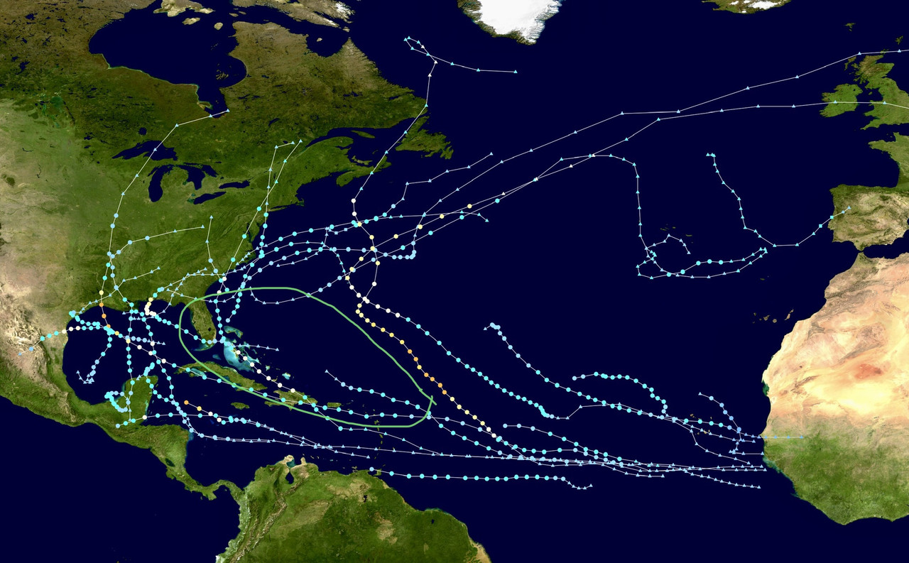
Despite this record-breaking season, there is noticeable lack of anything significant so far in the area I circled which ironically is probably the most vulnerable to hurricanes which includes peninsula Florida, the islands and the area south of Bermuda in the SW Atlantic. Isaias and Laura did move through this area but were not high impact wind storms:

Image
2 likes   


Return to “Talkin' Tropics”

Who is online

Users browsing this forum: CyclonicFury, Google Adsense [Bot], StormWeather, StPeteMike, Ulf and 46 guests