2020 Global Model Runs Discussion (Out thru day 16)
Moderator: S2k Moderators
Forum rules

The posts in this forum are NOT official forecasts and should not be used as such. They are just the opinion of the poster and may or may not be backed by sound meteorological data. They are NOT endorsed by any professional institution or STORM2K. For official information, please refer to products from the National Hurricane Center and National Weather Service.
-
gatorcane

- S2K Supporter

- Posts: 23708
- Age: 48
- Joined: Sun Mar 13, 2005 3:54 pm
- Location: Boca Raton, FL
Re: 2020 Global Model Runs Discussion (Out thru day 16)
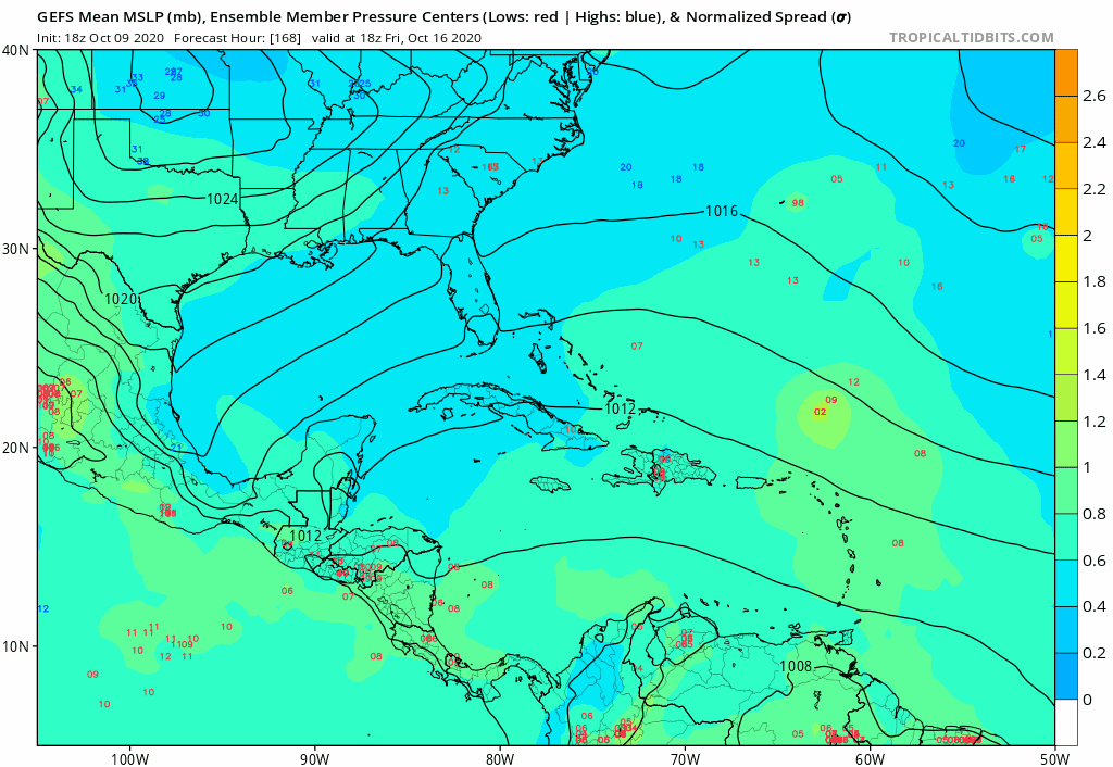
Not seeing much on the GEFS. Loop from 168-300 hours:
0 likes
-
SouthFLTropics

- Category 5

- Posts: 4258
- Age: 50
- Joined: Thu Aug 14, 2003 8:04 am
- Location: Port St. Lucie, Florida
Re: 2020 Global Model Runs Discussion (Out thru day 16)
Crickets on the 18z GFS. I’ll gladly take that and count our blessings here in South Florida. Let’s hope it continues to be that way.
Sent from my iPhone using Tapatalk
Sent from my iPhone using Tapatalk
0 likes
Fourth Generation Florida Native
Personal Storm History: David 79, Andrew 92, Erin 95, Floyd 99, Irene 99, Frances 04, Jeanne 04, Wilma 05, Matthew 16, Irma 17, Ian 22, Nicole 22, Milton 24
Personal Storm History: David 79, Andrew 92, Erin 95, Floyd 99, Irene 99, Frances 04, Jeanne 04, Wilma 05, Matthew 16, Irma 17, Ian 22, Nicole 22, Milton 24
-
supercane4867
- Category 5
- Posts: 4966
- Joined: Wed Nov 14, 2012 10:43 am
Re: 2020 Global Model Runs Discussion (Out thru day 16)
TheStormExpert wrote:supercane4867 wrote:https://twitter.com/derekortt/status/1314714456962879488?s=21
So why does the CAG have to spin up into a tropical cyclone in order to go away? Can’t it just wash itself out over Central America?
Don’t know much a whole lot about this so any input would be greatly appreciated!
I haven't really looked into this phenomenon too, but my amateur reasoning is that when every typical late season front sweeps through the GOM it almost always pull up something from the monsoon trough which tends to result in different levels of TC genesis, even if the end product is weak and short-lived(take Philippe 2017 as an example)
0 likes
-
SouthFLTropics
- Category 5
- Posts: 4258
- Age: 50
- Joined: Thu Aug 14, 2003 8:04 am
- Location: Port St. Lucie, Florida
2020 Global Model Runs Discussion (Out thru day 16)
FWIW, the 00z GFS spins something up in the Bahamas late in the run, crosses South Florida, and then makes a run on the already battered northern Gulf Coast.
Sent from my iPhone using Tapatalk
Sent from my iPhone using Tapatalk
0 likes
Fourth Generation Florida Native
Personal Storm History: David 79, Andrew 92, Erin 95, Floyd 99, Irene 99, Frances 04, Jeanne 04, Wilma 05, Matthew 16, Irma 17, Ian 22, Nicole 22, Milton 24
Personal Storm History: David 79, Andrew 92, Erin 95, Floyd 99, Irene 99, Frances 04, Jeanne 04, Wilma 05, Matthew 16, Irma 17, Ian 22, Nicole 22, Milton 24

Re: 2020 Global Model Runs Discussion (Out thru day 16)
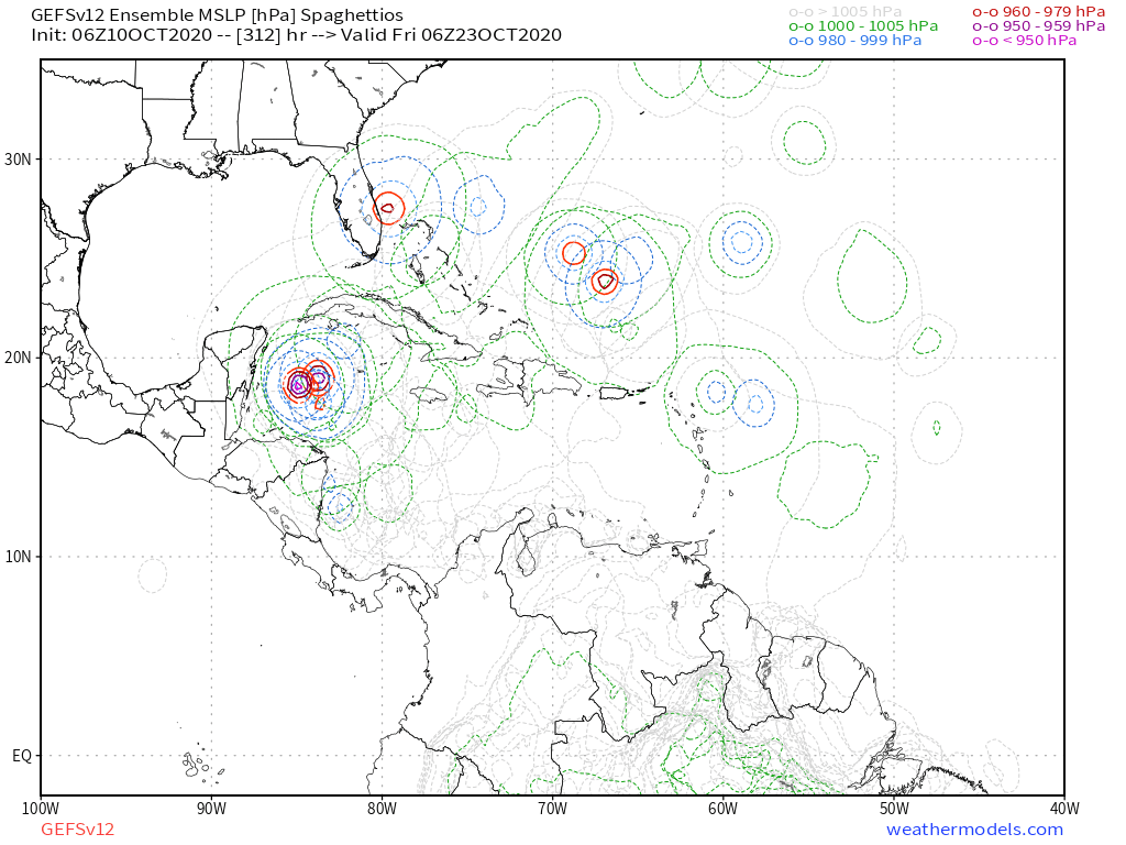
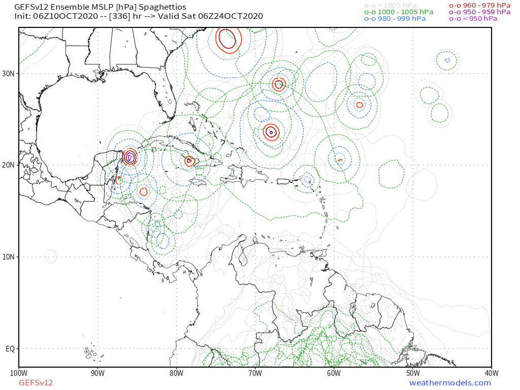
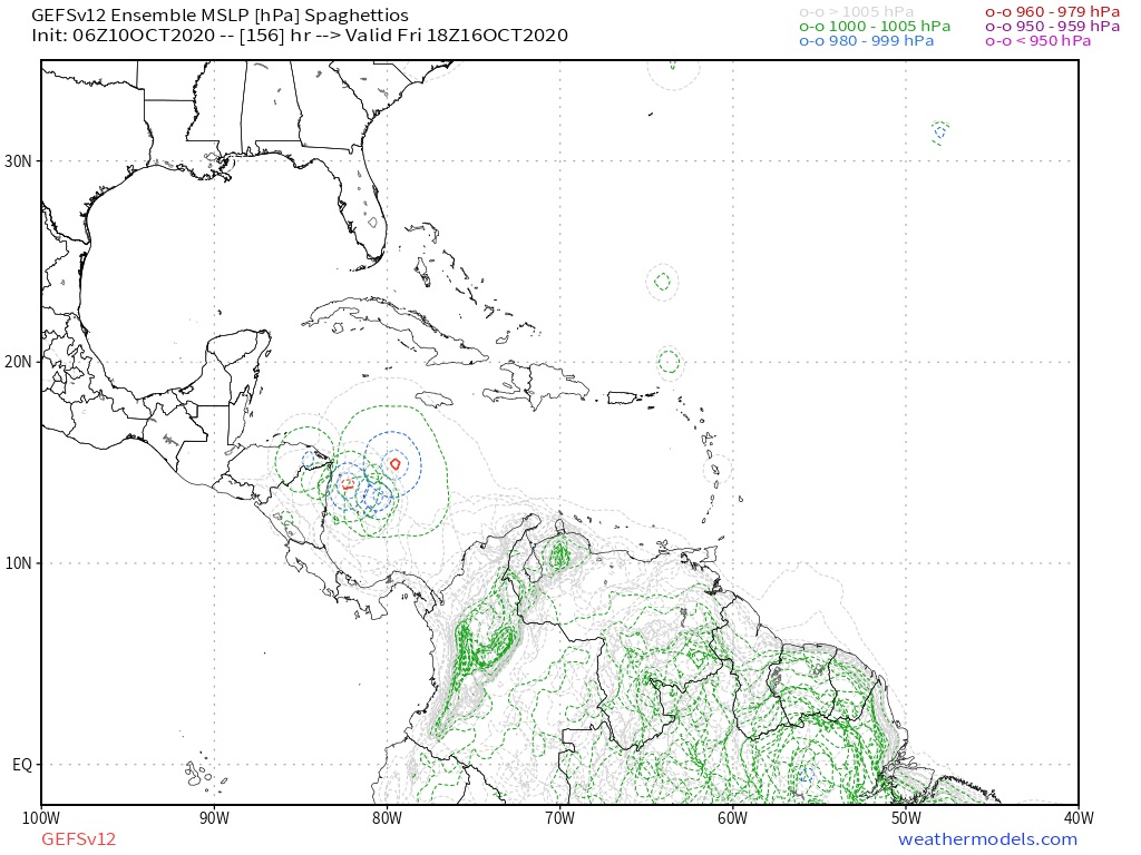
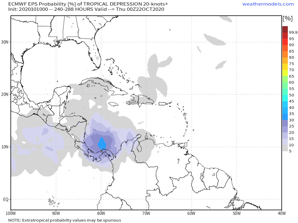
06z GFS already has multiple members with activity in the southernmost parts of the WCar at +120 hours. 18z GFS was very quiet regarding long range WCar storms, but 00z and 06z GFS are definitely more active and show earlier development. However, there's still a lot of uncertainty otherwise ensembles wouldn't go back and forth between many members with storms and no storms at all. Here's the 06z ensemble up to 300 hours, I think that's the best way to show what I mean. GFS is also still quite enthusiastic about storm genesis from the two tropical waves, even though it seems none of the current members go beyond TD/TS strength.
0 likes

Re: 2020 Global Model Runs Discussion (Out thru day 16)
What’s the precursor for this? Since development could start as early as next Friday, the precursor disturbance or whatever would spark development should be present somewhere.
0 likes
Irene '11 Sandy '12 Hermine '16 5/15/2018 Derecho Fay '20 Isaias '20 Elsa '21 Henri '21 Ida '21
I am only a meteorology enthusiast who knows a decent amount about tropical cyclones. Look to the professional mets, the NHC, or your local weather office for the best information.
I am only a meteorology enthusiast who knows a decent amount about tropical cyclones. Look to the professional mets, the NHC, or your local weather office for the best information.
-
crownweather

- S2K Supporter
- Posts: 602
- Age: 51
- Joined: Sat Aug 12, 2006 9:21 am
- Location: Sturbridge, Massachusetts
- Contact:
Re: 2020 Global Model Runs Discussion (Out thru day 16)
aspen wrote:
What’s the precursor for this? Since development could start as early as next Friday, the precursor disturbance or whatever would spark development should be present somewhere.
The disturbance that potentially sparks the development is the one that is now highlighted by NHC halfway between the coast of Africa and the Lesser Antilles near 35W.
3 likes
Rob Lightbown
Crown Weather Services
https://crownweather.com
Crown Weather Services
https://crownweather.com

Re: 2020 Global Model Runs Discussion (Out thru day 16)
crownweather wrote:aspen wrote:
What’s the precursor for this? Since development could start as early as next Friday, the precursor disturbance or whatever would spark development should be present somewhere.
The disturbance that potentially sparks the development is the one that is now highlighted by NHC halfway between the coast of Africa and the Lesser Antilles near 35W.
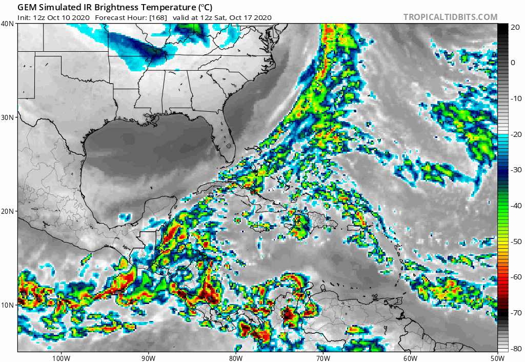
Correct, and in fact I was noticing this morning that this wave (already highlighted in a separate thread here) seems to be showing up on ICON, NOGAPS, GFS, and GFS-Para to differing degrees. Models suggest a disturbance possibly consolidating near or just north of Puerto Rico at around 180 hr's. Not sure whether any model members pinging on the S.W. Caribbean might be some reflection of the quicker westward motion of the southern axis of that same wave or of an altogether different origin.
0 likes
Andy D
(For official information, please refer to the NHC and NWS products.)
(For official information, please refer to the NHC and NWS products.)
Re: 2020 Global Model Runs Discussion (Out thru day 16)
Interesting. That's now both GEM and GFS suggesting something developing around 240 hr. just south of Jamaica.
0 likes
Andy D
(For official information, please refer to the NHC and NWS products.)
(For official information, please refer to the NHC and NWS products.)
-
Ivanhater

- Storm2k Moderator

- Posts: 11221
- Age: 39
- Joined: Fri Jul 01, 2005 8:25 am
- Location: Pensacola
Re: 2020 Global Model Runs Discussion (Out thru day 16)
I'll be at Universal studios in Orlando starting Oct 26th for a week. Watching closely hoping the weather cooperates!
3 likes
Michael
Re: 2020 Global Model Runs Discussion (Out thru day 16)
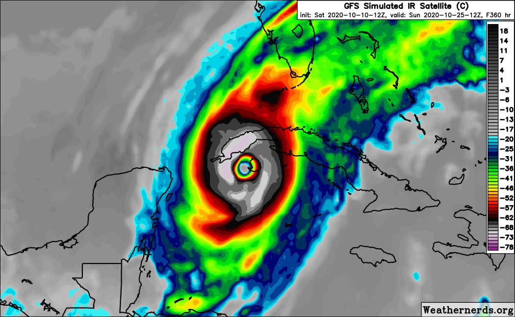
If Gamma and Delta were any indication, any system that develops in the WCar is probably going to go berserk. SSTs are still at least 29-29.5C with ridiculously high OHC. The GFS did a surprisingly good job sniffing them out two weeks in advance, so it might be on to something with “future Epsilon”.
Edit: referring to this as “future Epsilon” might be a bad idea, because 2020 really likes forming storms in pairs — Laura and Marco, Nana and Omar, Paulette and Rene, Sally and Beta, Teddy and Vicky, Wilfred and Alpha, and Gamma and Delta — so I won’t be surprised if another system forms around the same time as anything in the WCar. Maybe we’ll get Epsilon and Zeta within a few days of each other.
Edit: referring to this as “future Epsilon” might be a bad idea, because 2020 really likes forming storms in pairs — Laura and Marco, Nana and Omar, Paulette and Rene, Sally and Beta, Teddy and Vicky, Wilfred and Alpha, and Gamma and Delta — so I won’t be surprised if another system forms around the same time as anything in the WCar. Maybe we’ll get Epsilon and Zeta within a few days of each other.
5 likes
Irene '11 Sandy '12 Hermine '16 5/15/2018 Derecho Fay '20 Isaias '20 Elsa '21 Henri '21 Ida '21
I am only a meteorology enthusiast who knows a decent amount about tropical cyclones. Look to the professional mets, the NHC, or your local weather office for the best information.
I am only a meteorology enthusiast who knows a decent amount about tropical cyclones. Look to the professional mets, the NHC, or your local weather office for the best information.
-
SFLcane

- S2K Supporter
- Posts: 10281
- Age: 48
- Joined: Sat Jun 05, 2010 1:44 pm
- Location: Lake Worth Florida
Re: 2020 Global Model Runs Discussion (Out thru day 16)
Long/range GFS says this season isn’t over by a long shot. 
6 likes
-
SFLcane
- S2K Supporter
- Posts: 10281
- Age: 48
- Joined: Sat Jun 05, 2010 1:44 pm
- Location: Lake Worth Florida
Re: 2020 Global Model Runs Discussion (Out thru day 16)
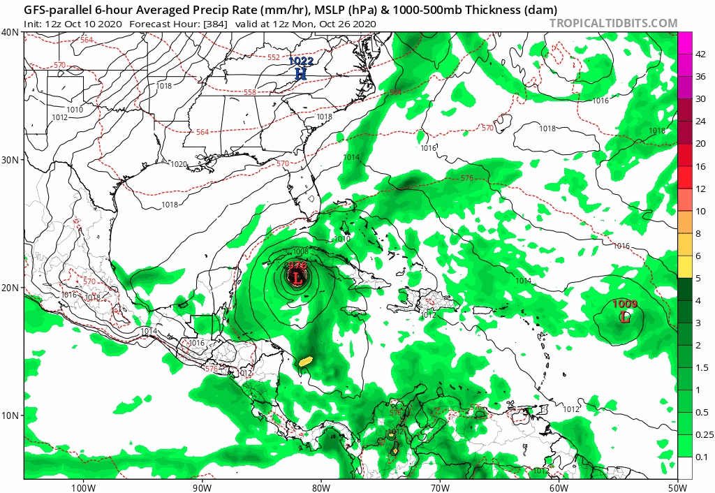
Gfs para also onboard with a strengthening hurricane heading north.
Last edited by SFLcane on Sat Oct 10, 2020 2:39 pm, edited 1 time in total.
1 likes
Re: 2020 Global Model Runs Discussion (Out thru day 16)
SFLcane wrote:Long/range GFS says this season isn’t over by a long shot.
https://i.postimg.cc/vHhGwFhB/BF2-BF9-F8-A277-492-A-959-A-E5-D1-A66-A4-FCB.jpg
Still very far out so whatever happens it probably won't play out exactly like that, but it would be quite something if after more than a decade without a WCar monster (15 years if you talk about October storms specifically) we have 2 in one year.
1 likes
-
toad strangler

- S2K Supporter
- Posts: 4546
- Joined: Sun Jul 28, 2013 3:09 pm
- Location: Earth
- Contact:
Re: 2020 Global Model Runs Discussion (Out thru day 16)
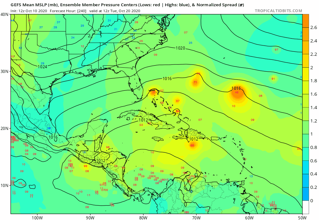
12z GFS Ensembles are a snooze fest for the CONUS.
0 likes
My Weather Station
https://www.wunderground.com/dashboard/pws/KFLPORTS603
https://www.wunderground.com/dashboard/pws/KFLPORTS603
-
gatorcane
- S2K Supporter
- Posts: 23708
- Age: 48
- Joined: Sun Mar 13, 2005 3:54 pm
- Location: Boca Raton, FL
Re: 2020 Global Model Runs Discussion (Out thru day 16)
toad strangler wrote:12z GFS Ensembles are a snooze fest for the CONUS.
Saved loop:
0 likes
-
supercane4867
- Category 5
- Posts: 4966
- Joined: Wed Nov 14, 2012 10:43 am
Re: 2020 Global Model Runs Discussion (Out thru day 16)
12z euro has the current MDR wave in western Caribbean by end of the run and also develops a stalled front in the subtropical Atlantic. Assume the former wave develops that would be Epsilon and Zeta in the next 10 days.
0 likes
Who is online
Users browsing this forum: Yellow Evan and 33 guests