

2020 Global Model Runs Discussion (Out thru day 16)
Moderator: S2k Moderators
Forum rules

The posts in this forum are NOT official forecasts and should not be used as such. They are just the opinion of the poster and may or may not be backed by sound meteorological data. They are NOT endorsed by any professional institution or STORM2K. For official information, please refer to products from the National Hurricane Center and National Weather Service.
Re: 2020 Global Model Runs Discussion (Out thru day 16)
Every time a trough has come down a system has formed close by. With one forecasted to come down along in the next 6-10 days along with forecasted large scale rising motion in the Caribbean, FL has to keep an eye on models over the next few days. Question is how much of a trough is in place and position for it to be a threat to FL.
7 likes
-
StPeteMike

- Category 2

- Posts: 655
- Joined: Thu Jun 07, 2018 11:26 pm
Re: 2020 Global Model Runs Discussion (Out thru day 16)
10 Day models are better to use for “how’s the environment then to create a storm” than actual strength and direction. 10 Day models were correct to forecast Delta yet all had it either as sheared mess impacting Florida or a Cat 3 impacting Florida.
It’s something to watch for sure and by next week, around Monday, we should have a better understanding of what this will become.
It’s something to watch for sure and by next week, around Monday, we should have a better understanding of what this will become.
5 likes
The above post is not official and should not be used as such. It is the opinion of the poster and may or may not be backed by sound meteorological data. It is not endorsed by any professional institution or storm2k.org. For official information, please refer to the NHC and NWS products.

-
SFLcane

- S2K Supporter

- Posts: 10281
- Age: 48
- Joined: Sat Jun 05, 2010 1:44 pm
- Location: Lake Worth Florida
Re: 2020 Global Model Runs Discussion (Out thru day 16)
Had to drop this here from our very own wxman57...
Get ready for late-season development in 8-10 days in the western Caribbean. As JB would say, "it's like the Simon & Garfunkle song - ridge over troubled water". High pressure across the U.S. and Gulf, low pressure across the Caribbean. Prime setup for late season development. I think this will be Epsilon by the 21st or so. Doesn't look like a northern Gulf threat. More likely Central America or a Wilma-type track that may threaten Cuba, south Florida, and/or the Bahamas.
Get ready for late-season development in 8-10 days in the western Caribbean. As JB would say, "it's like the Simon & Garfunkle song - ridge over troubled water". High pressure across the U.S. and Gulf, low pressure across the Caribbean. Prime setup for late season development. I think this will be Epsilon by the 21st or so. Doesn't look like a northern Gulf threat. More likely Central America or a Wilma-type track that may threaten Cuba, south Florida, and/or the Bahamas.
5 likes

-
gatorcane

- S2K Supporter
- Posts: 23708
- Age: 48
- Joined: Sun Mar 13, 2005 3:54 pm
- Location: Boca Raton, FL
Re: 2020 Global Model Runs Discussion (Out thru day 16)
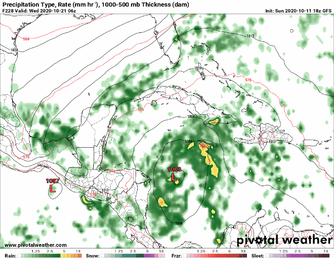
12Z GFS has it again and is more east as it ejects out of the Western Caribbean:
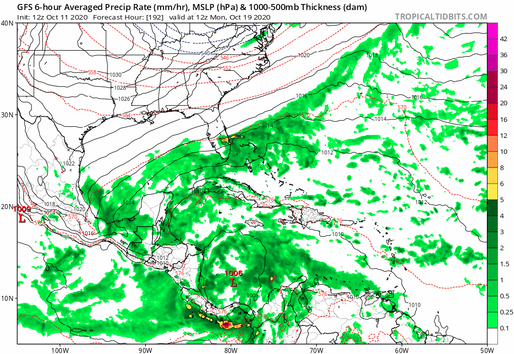
0 likes
-
gatorcane
- S2K Supporter
- Posts: 23708
- Age: 48
- Joined: Sun Mar 13, 2005 3:54 pm
- Location: Boca Raton, FL
Re: 2020 Global Model Runs Discussion (Out thru day 16)
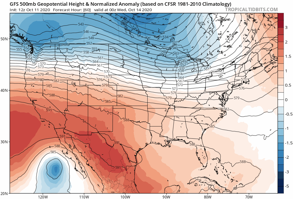
While the GFS shows the Western Caribbean system look at the long-wave pattern in the long-range, very fall-like and would allow the westerlies to drop south and possibly remain permanently:
0 likes
-
cycloneye

- Admin

- Posts: 149438
- Age: 69
- Joined: Thu Oct 10, 2002 10:54 am
- Location: San Juan, Puerto Rico
Re: 2020 Global Model Runs Discussion (Out thru day 16)
All the models related to the wave now as 93L can be posted in the Invest 93L models thread
0 likes
Visit the Caribbean-Central America Weather Thread where you can find at first post web cams,radars
and observations from Caribbean basin members Click Here
and observations from Caribbean basin members Click Here
-
SFLcane
- S2K Supporter
- Posts: 10281
- Age: 48
- Joined: Sat Jun 05, 2010 1:44 pm
- Location: Lake Worth Florida
Re: 2020 Global Model Runs Discussion (Out thru day 16)
gatorcane wrote:While the GFS shows the Western Caribbean system look at the long-wave pattern in the long-range, very fall-like and would allow the westerlies to drop south and possibly remain permanently:
https://i.postimg.cc/qMPLKynT/gfs-z500a-Norm-us-fh60-240.gif
That’s why we in SFL should watch.
0 likes
-
Loveweather12
- Tropical Storm

- Posts: 136
- Joined: Thu Aug 20, 2020 2:37 pm
Re: 2020 Global Model Runs Discussion (Out thru day 16)
How do the westerlies affect FL?
SFLcane wrote:gatorcane wrote:While the GFS shows the Western Caribbean system look at the long-wave pattern in the long-range, very fall-like and would allow the westerlies to drop south and possibly remain permanently:
https://i.postimg.cc/qMPLKynT/gfs-z500a-Norm-us-fh60-240.gif
That’s why we in SFL should watch.
0 likes
-
gatorcane
- S2K Supporter
- Posts: 23708
- Age: 48
- Joined: Sun Mar 13, 2005 3:54 pm
- Location: Boca Raton, FL
Re: 2020 Global Model Runs Discussion (Out thru day 16)
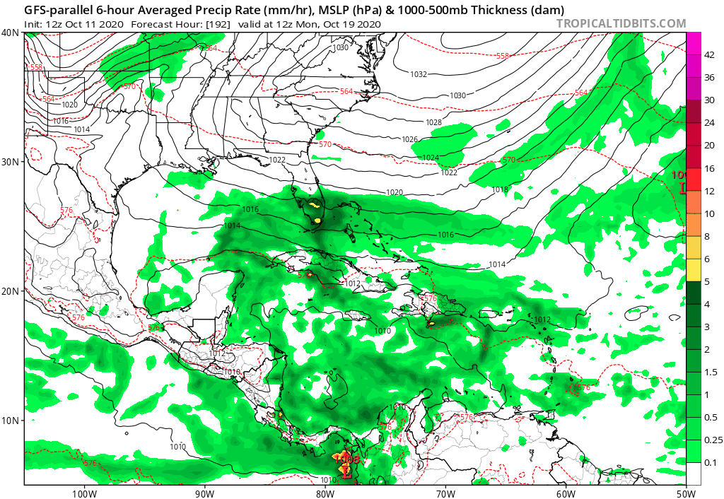
GFS P long-range animation. Note the SW Caribbean system appears to be of different origin than 93l:
0 likes


Re: 2020 Global Model Runs Discussion (Out thru day 16)
I’m already getting confused over what is expected to trigger development of the WCar system. Is 93L going to at least play some role, like how Gamma and Delta both came from AEWs? Or is it some broad low that is completely unassociated with any wave? Either way, we should have a better picture on how development would proceed by mid-week, as 93L enters the Caribbean and development is modeled within 96-144 hours.
0 likes
Irene '11 Sandy '12 Hermine '16 5/15/2018 Derecho Fay '20 Isaias '20 Elsa '21 Henri '21 Ida '21
I am only a meteorology enthusiast who knows a decent amount about tropical cyclones. Look to the professional mets, the NHC, or your local weather office for the best information.
I am only a meteorology enthusiast who knows a decent amount about tropical cyclones. Look to the professional mets, the NHC, or your local weather office for the best information.

Re: 2020 Global Model Runs Discussion (Out thru day 16)
12z Euro +240
Sent from my iPhone using Tapatalk
Sent from my iPhone using Tapatalk
0 likes
-
AJC3

- Admin
- Posts: 4155
- Age: 62
- Joined: Tue Aug 31, 2004 7:04 pm
- Location: Ballston Spa, New York
- Contact:
Re: 2020 Global Model Runs Discussion (Out thru day 16)
aspen wrote:I’m already getting confused over what is expected to trigger development of the WCar system. Is 93L going to at least play some role, like how Gamma and Delta both came from AEWs? Or is it some broad low that is completely unassociated with any wave? Either way, we should have a better picture on how development would proceed by mid-week, as 93L enters the Caribbean and development is modeled within 96-144 hours.
From what I've seen in the high-res model guidance, the T-wave associated with 93L dampens out, but doesn't completely flatten as it slowly crosses the eastern and central north Caribbean (near the GA). While that is occurring, a larger gyre, separate from 93L, starts to form over the SW Caribbean Sea. Whatever remnant lobe of vorticity from 93L exists in about a week rotates around the northern side of the gyre before becoming a part of it between days 8-10.
Looking at this from the perspective of a moderator, I've been going back and forth on this as far as what do to to try and minimize the amount of cross-posting of the same content that is likely to occur both here and in the 93L Models thread. Up until this point, I had been leaning toward trying to combine the posts into the 93L Models thread, however the more I look at it, the more I lean toward keeping them separate since the dominant feature seems to be the gyre spinning up over the SW Caribbean.
8 likes
-
SFLcane
- S2K Supporter
- Posts: 10281
- Age: 48
- Joined: Sat Jun 05, 2010 1:44 pm
- Location: Lake Worth Florida
Re: 2020 Global Model Runs Discussion (Out thru day 16)
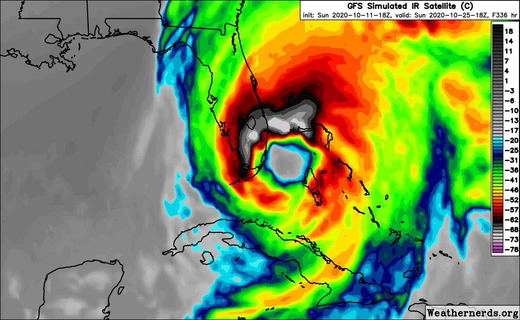
Gfs continues with a large powerful Hurricane in the sw Carib.
0 likes
-
SFLcane
- S2K Supporter
- Posts: 10281
- Age: 48
- Joined: Sat Jun 05, 2010 1:44 pm
- Location: Lake Worth Florida

Re: 2020 Global Model Runs Discussion (Out thru day 16)
SFLcane wrote:Ok GFS....
https://i.postimg.cc/W1rwvXRh/CC6814-EC-7789-41-C0-B87-A-882-C8-AC98701.gif
Happy Hour GFS really living up to its name with a Caribbean Fujiwhara. Since it has so much unusual and probably unlikely interaction between two vortices, I would assume the actual development time of the system would be faster. It seems highly unlikely a single WCar gyre would spawn two systems that close to each other.
It still has the gyre developing on October 19th. That’s the “magic date” we need to keep an eye on to see if the GFS keeps development then, or continues to shift it several days later and later.
0 likes
Irene '11 Sandy '12 Hermine '16 5/15/2018 Derecho Fay '20 Isaias '20 Elsa '21 Henri '21 Ida '21
I am only a meteorology enthusiast who knows a decent amount about tropical cyclones. Look to the professional mets, the NHC, or your local weather office for the best information.
I am only a meteorology enthusiast who knows a decent amount about tropical cyclones. Look to the professional mets, the NHC, or your local weather office for the best information.
Who is online
Users browsing this forum: No registered users and 273 guests