2020 Global Model Runs Discussion (Out thru day 16)
Moderator: S2k Moderators
Forum rules

The posts in this forum are NOT official forecasts and should not be used as such. They are just the opinion of the poster and may or may not be backed by sound meteorological data. They are NOT endorsed by any professional institution or STORM2K. For official information, please refer to products from the National Hurricane Center and National Weather Service.
-
chris_fit

- Category 5

- Posts: 3261
- Age: 43
- Joined: Wed Sep 10, 2003 11:58 pm
- Location: Tampa Bay Area, FL
Re: 2020 Global Model Runs Discussion (Out thru day 16)
Not saying a pattern/overall setup like that is not impossible, but an exact solution like that, 12+ days out, don't think so, never has happened before and probably never will.
0 likes

Re: 2020 Global Model Runs Discussion (Out thru day 16)
There are now three systems that could develop within the next 8-10 days:
1.) the WCar TC we’ve been monitoring for the last several days. The precursor gyre appears to show up around October 18th-20th
2.) Invest 93L, which might get north of the GAs intact. Some GFS-Para, CMC, and ICON runs have shown development after 5 days
3.) a central Atlantic STC which could begin forming as early at Friday. The GFS, GFS-Para, CMC, and ICON show at least some development
If all three of these systems come to fruition, we could hit Eta and 2005’s NS total before October 25th.
Edit: there’s also an AEW with some model support for weak development, but since Cape Verde season should be done for the year, I don’t anticipate much from it
4 likes
Irene '11 Sandy '12 Hermine '16 5/15/2018 Derecho Fay '20 Isaias '20 Elsa '21 Henri '21 Ida '21
I am only a meteorology enthusiast who knows a decent amount about tropical cyclones. Look to the professional mets, the NHC, or your local weather office for the best information.
I am only a meteorology enthusiast who knows a decent amount about tropical cyclones. Look to the professional mets, the NHC, or your local weather office for the best information.
-
TheStormExpert
Re: 2020 Global Model Runs Discussion (Out thru day 16)
All we know now is an area of low pressure is going to form in the Southwestern Caribbean next Monday the 19th. From there who knows! Could go anywhere from straight into Central America to through Cuba and The Bahamas and OTS. This could likely be the 2020 Hurricane Seasons last punch. So why not go out with a bang!

0 likes
-
cheezyWXguy

- Category 5
- Posts: 6282
- Joined: Mon Feb 13, 2006 12:29 am
- Location: Dallas, TX
Re: 2020 Global Model Runs Discussion (Out thru day 16)
chris_fit wrote:Not saying a pattern/overall setup like that is not impossible, but an exact solution like that, 12+ days out, don't think so, never has happened before and probably never will.
No 2 storms practically ever take the exact same path, so your statement is basically unfalsifiable. At 12+ days out, it is just as unreasonable to discount certain tracks as it is to take them verbatim. This is one of many possible outcomes, and it is a climatologically favored track, specific landfall location aside.
0 likes
-
toad strangler

- S2K Supporter

- Posts: 4546
- Joined: Sun Jul 28, 2013 3:09 pm
- Location: Earth
- Contact:
Re: 2020 Global Model Runs Discussion (Out thru day 16)
12z GEFS tracks are scatter shot all over the Caribbean, as you would expect at this crazy long range.
0 likes
My Weather Station
https://www.wunderground.com/dashboard/pws/KFLPORTS603
https://www.wunderground.com/dashboard/pws/KFLPORTS603

Re: 2020 Global Model Runs Discussion (Out thru day 16)
I knew something crazy happened when 3 pages were added to this thread since I last looked at it just a few hours ago. But I didn't expect it to be a GFS run going RI. Considering GFS is always way too high with pressure due to its low resolution I can imagine that the actual central storm pressure in this run might be 920 - 930 mbar, if not lower. Luckily it's still almost 300 hours out before the storm gets that strong so there is more than a week left in which the models will undoubtedly shift and change a lot, but it does show the high potential for any storm that forms in the WCar. For a few days now Oct 20/21 seems to be the period where a TD forms in the GFS run so that's the time period we have to keep in mind. In the 12z ensemble run 6/21 members (29%) make landfall in Florida at hurricane strength (even though most do this in the 300 - 384 hrs range), so besides Cuba and the Central America, this is most definitely also a system the US has to be mindful of.
1 likes
-
HurricaneBelle

- S2K Supporter
- Posts: 1209
- Joined: Sun Aug 27, 2006 6:12 pm
- Location: Clearwater, FL
Re: 2020 Global Model Runs Discussion (Out thru day 16)
cp79 wrote:toad strangler wrote:Whoa baby Tampa hold on to your ROOFS .... if you believe 12z 300 hour plus Alice in Wonderland
Yeah it’s actually the same exact track and scenario when they simulated Hurricane Phoenix...a cat 5 simulation over Tampa Bay.
The good news is they’re showing this track 12 days out. These tracks always change so better to show it over Tampa now than in two weeks when there’s a 99% chance it will be something completely opposite. But I do think that something will get cooking in the Caribbean next week.
Looking closely at this track, it looks like it landfalls around Bradenton/Sarasota, which would spare Tampa Bay the nightmare surge scenario. It would still be unbelievably bad in Pinellas/Hillsborough and east-facing coasts (like near downtown St. Pete & NE St. Pete) would be inundated.
0 likes
-
Shell Mound
- Category 5
- Posts: 2432
- Age: 33
- Joined: Thu Sep 07, 2017 3:39 pm
- Location: St. Petersburg, FL → Scandinavia
Re: 2020 Global Model Runs Discussion (Out thru day 16)
Blown Away wrote:aspen wrote:06z GFS-Para doesn’t show significant development, and that’s because it’s confused about the size of the gyre; it makes it larger than the entire Gulf of Mexico.
Many times as the models start closing in on a time we will see a much different solution from the long range. No surprise if no development, bury into CA, or a classic storm being ejected NE over Cuba/SFL/Bahamas. The pseudo La Niña influence does give the Cuba/SFL/Bahamas idea a little more probability compared to the norm. JMHO
Going back to 1851, I found that virtually all hurricanes to impact Florida in October reached 83–6°W at 20°N in the western Caribbean. Most of them impacted westernmost Cuba first before striking Florida. Note that 25 October marks the latest date on which a major hurricane—the 1921 Tampa Bay hurricane, to be specific—has impacted the (mainland) U.S. in the calendar-year. (Wilma ‘05 impacted Florida just one day earlier, on 24 October.) King ‘50 and Michael ‘18 were the only Category-4+ hits on record; all the other hits were Cat-3 or weaker.
1 likes
CVW / MiamiensisWx / Shell Mound
The posts in this forum are NOT official forecasts and should not be used as such. They are just the opinion of the poster and may or may not be backed by sound meteorological data. They are NOT endorsed by any professional institution or STORM2K. For official information, please refer to products from the NHC and NWS.
-
toad strangler
- S2K Supporter
- Posts: 4546
- Joined: Sun Jul 28, 2013 3:09 pm
- Location: Earth
- Contact:
Re: 2020 Global Model Runs Discussion (Out thru day 16)
12z Euro ends with vorticity starting to spin in the far SW caribbean.
0 likes
My Weather Station
https://www.wunderground.com/dashboard/pws/KFLPORTS603
https://www.wunderground.com/dashboard/pws/KFLPORTS603
-
AutoPenalti
- Category 5
- Posts: 4091
- Age: 29
- Joined: Mon Aug 17, 2015 4:16 pm
- Location: Ft. Lauderdale, Florida
Re: 2020 Global Model Runs Discussion (Out thru day 16)
toad strangler wrote:12z Euro ends with vorticity starting to spin in the far SW caribbean.
Ruh-roh.
0 likes
The posts in this forum are NOT official forecasts and should not be used as such. They are just the opinion of the poster and may or may not be backed by sound meteorological data. They are NOT endorsed by any professional institution or STORM2K. For official information, please refer to products from the NHC and NWS.
Model Runs Cheat Sheet:
GFS (5:30 AM/PM, 11:30 AM/PM)
HWRF, GFDL, UKMET, NAVGEM (6:30-8:00 AM/PM, 12:30-2:00 AM/PM)
ECMWF (1:45 AM/PM)
TCVN is a weighted averaged
-
otowntiger
- Category 5
- Posts: 1932
- Joined: Tue Aug 31, 2004 7:06 pm
Re: 2020 Global Model Runs Discussion (Out thru day 16)
What the GFS is showing 360 hours out is indeed 'Fantasy Land' as they say, but when the Euro starts to get in on the action, there is reason to believe something could come of it. We'll see. I agree that models show possibilities and Climo does say GFS solution is not out of the realm of possibility. However I've seen seemingly hundreds of model solutions over the years show some kind of catastrophic solution for major landfalling hurricanes on the FL penninsula only to maybe have 1 out of 500 actually verify. (I'm making up the numbers of course - the point is a very low percentage actually come to fruition). What these models do say is though is that the season isn't over and significant storms could still be in the offing.toad strangler wrote:12z Euro ends with vorticity starting to spin in the far SW caribbean.
4 likes
-
toad strangler
- S2K Supporter
- Posts: 4546
- Joined: Sun Jul 28, 2013 3:09 pm
- Location: Earth
- Contact:
Re: 2020 Global Model Runs Discussion (Out thru day 16)
otowntiger wrote:What the GFS is showing 360 hours out is indeed 'Fantasy Land' as they say, but when the Euro starts to get in on the action, there is reason to believe something could come of it. We'll see. I agree that models show possibilities and Climo does say GFS solution is not out of the realm of possibility. However I've seen seemingly hundreds of model solutions over the years show some kind of catastrophic solution for major landfalling hurricanes on the FL penninsula only to maybe have 1 out of 500 actually verify. (I'm making up the numbers of course - the point is a very low percentage actually come to fruition). What these models do say is though is that the season isn't over and significant storms could still be in the offing.toad strangler wrote:12z Euro ends with vorticity starting to spin in the far SW caribbean.
Agree and have been singing this song for the entire last week. I too have seen many model Caribbean late October storms that have turned out to be nada. This year may be different with La Nina and upward motion on hand. So, we watch.
1 likes
My Weather Station
https://www.wunderground.com/dashboard/pws/KFLPORTS603
https://www.wunderground.com/dashboard/pws/KFLPORTS603
-
cycloneye

- Admin

- Posts: 149438
- Age: 69
- Joined: Thu Oct 10, 2002 10:54 am
- Location: San Juan, Puerto Rico
Re: 2020 Global Model Runs Discussion (Out thru day 16)
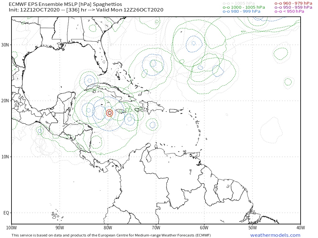
Adrian, what do the ECMWF ensembles have at 12z?
0 likes
Visit the Caribbean-Central America Weather Thread where you can find at first post web cams,radars
and observations from Caribbean basin members Click Here
and observations from Caribbean basin members Click Here
-
SFLcane

- S2K Supporter
- Posts: 10281
- Age: 48
- Joined: Sat Jun 05, 2010 1:44 pm
- Location: Lake Worth Florida
Re: 2020 Global Model Runs Discussion (Out thru day 16)
cycloneye wrote:Adrian, what do the ECMWF ensembles have at 12z?
Not much for now, but eps has not done well this season. A few ensembles 300+ hrs out
1 likes
Re: 2020 Global Model Runs Discussion (Out thru day 16)
12Z para-GFS is several hundred miles E of FL in the central Bahamas. Is this a reasonable possibility? Climo says tracks either over or E of FL are about equally possible during mid to late Oct. So, at least climo says it is quite believable. Opinions?
Fwiw, a good number of ensemble members are E of FL.
What do you folks think will happen? Track over FL? Track E of FL? Track W of FL? No W Car TC?Anyone want to predict?
Edit: The last 3 para-GFS runs have been E of FL.
Fwiw, a good number of ensemble members are E of FL.
What do you folks think will happen? Track over FL? Track E of FL? Track W of FL? No W Car TC?Anyone want to predict?
Edit: The last 3 para-GFS runs have been E of FL.
0 likes
Personal Forecast Disclaimer:
The posts in this forum are NOT official forecasts and should not be used as such. They are just the opinion of the poster and may or may not be backed by sound meteorological data. They are NOT endorsed by any professional institution or storm2k.org. For official information, please refer to the NHC and NWS products.
The posts in this forum are NOT official forecasts and should not be used as such. They are just the opinion of the poster and may or may not be backed by sound meteorological data. They are NOT endorsed by any professional institution or storm2k.org. For official information, please refer to the NHC and NWS products.
-
SFLcane
- S2K Supporter
- Posts: 10281
- Age: 48
- Joined: Sat Jun 05, 2010 1:44 pm
- Location: Lake Worth Florida
Re: 2020 Global Model Runs Discussion (Out thru day 16)
LarryWx wrote:12Z para-GFS is several hundred miles E of FL in the central Bahamas. Is this a reasonable possibility? Climo says tracks either over or E of FL are about equally possible during mid to late Oct. So, at least climo says it is quite believable. Opinions?
Fwiw, a good number of ensemble members are E of FL.
What do you folks think will happen? Track over FL? Track E of FL? Track W of FL? No W Car TC?Anyone want to predict?
Edit: The last 3 para-GFS runs have been E of FL.
1- Track south of Florida heading north just missing the state or into South Florida.
2-Track towards Yucatán then swept NE towards west coast of FL by approaching trof of low pressure.
I for one the odds are quite high something will form and giving the time of the year It could very well impact the state. You think this season is not going to cover all its basis before it’s all said and done?
1 likes
-
toad strangler
- S2K Supporter
- Posts: 4546
- Joined: Sun Jul 28, 2013 3:09 pm
- Location: Earth
- Contact:
Re: 2020 Global Model Runs Discussion (Out thru day 16)
LarryWx wrote:12Z para-GFS is several hundred miles E of FL in the central Bahamas. Is this a reasonable possibility? Climo says tracks either over or E of FL are about equally possible during mid to late Oct. So, at least climo says it is quite believable. Opinions?
Fwiw, a good number of ensemble members are E of FL.
What do you folks think will happen? Track over FL? Track E of FL? Track W of FL? No W Car TC?Anyone want to predict?
Edit: The last 3 para-GFS runs have been E of FL.
Wasn’t the Para way too East in the longer range with Delta?
1 likes
My Weather Station
https://www.wunderground.com/dashboard/pws/KFLPORTS603
https://www.wunderground.com/dashboard/pws/KFLPORTS603
-
cp79
Re: 2020 Global Model Runs Discussion (Out thru day 16)
LarryWx wrote:12Z para-GFS is several hundred miles E of FL in the central Bahamas. Is this a reasonable possibility? Climo says tracks either over or E of FL are about equally possible during mid to late Oct. So, at least climo says it is quite believable. Opinions?
Fwiw, a good number of ensemble members are E of FL.
What do you folks think will happen? Track over FL? Track E of FL? Track W of FL? No W Car TC?Anyone want to predict?
Edit: The last 3 para-GFS runs have been E of FL.
It will all depend on how far south the front gets. If it goes through Fla it blocks it from hitting the state. If it stalls out north of Fla, it picks it up and sends it somewhere toward the west coast or panhandle, depending on how deep it gets. Of course timing a key factor too.
3 likes
-
SFLcane
- S2K Supporter
- Posts: 10281
- Age: 48
- Joined: Sat Jun 05, 2010 1:44 pm
- Location: Lake Worth Florida
Re: 2020 Global Model Runs Discussion (Out thru day 16)
toad strangler wrote:LarryWx wrote:12Z para-GFS is several hundred miles E of FL in the central Bahamas. Is this a reasonable possibility? Climo says tracks either over or E of FL are about equally possible during mid to late Oct. So, at least climo says it is quite believable. Opinions?
Fwiw, a good number of ensemble members are E of FL.
What do you folks think will happen? Track over FL? Track E of FL? Track W of FL? No W Car TC?Anyone want to predict?
Edit: The last 3 para-GFS runs have been E of FL.
Wasn’t the Para way too East in the longer range with Delta?
Yep..
1 likes
Who is online
Users browsing this forum: No registered users and 164 guests