2020 Global Model Runs Discussion (Out thru day 16)
Moderator: S2k Moderators
Forum rules

The posts in this forum are NOT official forecasts and should not be used as such. They are just the opinion of the poster and may or may not be backed by sound meteorological data. They are NOT endorsed by any professional institution or STORM2K. For official information, please refer to products from the National Hurricane Center and National Weather Service.

Re: 2020 Global Model Runs Discussion (Out thru day 16)
That subtropical system could become Hurricane Epsilon 2: Electric Boogaloo, assuming the GFS-Para is right. Development starts as early as 4-5 days out, so it should get a mention on a TWO in a few days, and it would get the name Epsilon well before the WCar system. I’m hoping it becomes a wacky and interesting to track late season mid-latitude wanderer like its predecessor.
4 likes
Irene '11 Sandy '12 Hermine '16 5/15/2018 Derecho Fay '20 Isaias '20 Elsa '21 Henri '21 Ida '21
I am only a meteorology enthusiast who knows a decent amount about tropical cyclones. Look to the professional mets, the NHC, or your local weather office for the best information.
I am only a meteorology enthusiast who knows a decent amount about tropical cyclones. Look to the professional mets, the NHC, or your local weather office for the best information.
-
GeneratorPower

- S2K Supporter

- Posts: 1648
- Age: 46
- Joined: Sun Dec 18, 2005 11:48 pm
- Location: Huntsville, AL
Re: 2020 Global Model Runs Discussion (Out thru day 16)
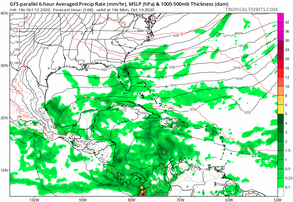
gatorcane wrote:Missing GFS-P frames but yikes
https://i.postimg.cc/1z52w1kw/gfsp-mslp-pcpn-watl-fh168-300.gif
How did you upload that and get the gif to play? I’m
Having no luck.
0 likes

Re: 2020 Global Model Runs Discussion (Out thru day 16)
gatorcane wrote:Missing GFS-P frames but yikes
https://i.postimg.cc/1z52w1kw/gfsp-mslp-pcpn-watl-fh168-300.gif
Further West over Central Cuba/Bahamas. Also much stronger.
0 likes
The following post is NOT an official forecast and should not be used as such. It is just the opinion of the poster and may or may not be backed by sound meteorological data. It is NOT endorsed by any professional institution including storm2k.org For Official Information please refer to the NHC and NWS products.
-
SFLcane

- S2K Supporter
- Posts: 10281
- Age: 48
- Joined: Sat Jun 05, 2010 1:44 pm
- Location: Lake Worth Florida
Re: 2020 Global Model Runs Discussion (Out thru day 16)
blp wrote:gatorcane wrote:Missing GFS-P frames but yikes
https://i.postimg.cc/1z52w1kw/gfsp-mslp-pcpn-watl-fh168-300.gif
Further West over Central Cuba/Bahamas. Also much stronger.

0 likes
Re: 2020 Global Model Runs Discussion (Out thru day 16)
gatorcane wrote:Missing GFS-P frames but yikes
https://i.postimg.cc/1z52w1kw/gfsp-mslp-pcpn-watl-fh168-300.gif
Very slow movement as well. The broad area of spin and moisture forms on October 19th, Zeta has formed by the 21st, and RI continues until a Cuba landfall that doesn’t happen until late on the 23rd/early on the 24th. 4-5 full days over the 30C waters of the Caribbean could be a recipe for a monster of a hurricane if the rest of the environment is anything like what Gamma and Delta had.
0 likes
Irene '11 Sandy '12 Hermine '16 5/15/2018 Derecho Fay '20 Isaias '20 Elsa '21 Henri '21 Ida '21
I am only a meteorology enthusiast who knows a decent amount about tropical cyclones. Look to the professional mets, the NHC, or your local weather office for the best information.
I am only a meteorology enthusiast who knows a decent amount about tropical cyclones. Look to the professional mets, the NHC, or your local weather office for the best information.
-
AutoPenalti
- Category 5

- Posts: 4091
- Age: 29
- Joined: Mon Aug 17, 2015 4:16 pm
- Location: Ft. Lauderdale, Florida
Re: 2020 Global Model Runs Discussion (Out thru day 16)
GFS P completely disregards weakening over land?
0 likes
The posts in this forum are NOT official forecasts and should not be used as such. They are just the opinion of the poster and may or may not be backed by sound meteorological data. They are NOT endorsed by any professional institution or STORM2K. For official information, please refer to products from the NHC and NWS.
Model Runs Cheat Sheet:
GFS (5:30 AM/PM, 11:30 AM/PM)
HWRF, GFDL, UKMET, NAVGEM (6:30-8:00 AM/PM, 12:30-2:00 AM/PM)
ECMWF (1:45 AM/PM)
TCVN is a weighted averaged
Re: 2020 Global Model Runs Discussion (Out thru day 16)
939 mbar landfall in central Cuba on the 18z GFS-Para
1 likes
Irene '11 Sandy '12 Hermine '16 5/15/2018 Derecho Fay '20 Isaias '20 Elsa '21 Henri '21 Ida '21
I am only a meteorology enthusiast who knows a decent amount about tropical cyclones. Look to the professional mets, the NHC, or your local weather office for the best information.
I am only a meteorology enthusiast who knows a decent amount about tropical cyclones. Look to the professional mets, the NHC, or your local weather office for the best information.
-
Blown Away

- S2K Supporter
- Posts: 10253
- Joined: Wed May 26, 2004 6:17 am
Re: 2020 Global Model Runs Discussion (Out thru day 16)
GFS & GFS Parallel have been showing a strong hurricane in 300+ hour near SFL/Bahamas for a few runs and if it’s not a phantom it’s gotta start being in the <300 hr range starting tomorrow IMO...
0 likes
Hurricane Eye Experience: David 79, Irene 99, Frances 04, Jeanne 04, Wilma 05… Hurricane Brush Experience: Andrew 92, Erin 95, Floyd 99, Matthew 16, Irma 17, Ian 22, Nicole 22…
Re: 2020 Global Model Runs Discussion (Out thru day 16)
If the last several GFS and GFS-Para runs even at least partially verify:
—Epsilon and Zeta will form within the next two weeks
—The subtropical system (Epsilon) should begin forming between Friday and Sunday, and could wander around for a while
—The WCar system (Zeta) will come out of a slow-moving gyre that appears on the 19th
—Zeta could be pretty slow-moving and have several days to intensify before making landfall in Cuba (and possibly Jamaica as well)
—Zeta could be another strong, rather long-lasting, and impactful major hurricane which could pump out 15-25 ACE, especially if it ends up like the 18z Para run
2 likes
Irene '11 Sandy '12 Hermine '16 5/15/2018 Derecho Fay '20 Isaias '20 Elsa '21 Henri '21 Ida '21
I am only a meteorology enthusiast who knows a decent amount about tropical cyclones. Look to the professional mets, the NHC, or your local weather office for the best information.
I am only a meteorology enthusiast who knows a decent amount about tropical cyclones. Look to the professional mets, the NHC, or your local weather office for the best information.
Re: 2020 Global Model Runs Discussion (Out thru day 16)
Blown Away wrote:GFS & GFS Parallel have been showing a strong hurricane in 300+ hour near SFL/Bahamas for a few runs and if it’s not a phantom it’s gotta start being in the <300 hr range starting tomorrow IMO...
The time frame for when the precursor gyre starts to develop has remained under 200 hours and around the 19th/20th for the last several days. This looks to be a slower and more complicated genesis than Gamma or Delta, but if the time frame has been pushed back several days by late week/the weekend, then it’s likely a phantom. If the GFS and GFS-Para continue to show that gyre on the 19th/20th, then it’s definitely real.
1 likes
Irene '11 Sandy '12 Hermine '16 5/15/2018 Derecho Fay '20 Isaias '20 Elsa '21 Henri '21 Ida '21
I am only a meteorology enthusiast who knows a decent amount about tropical cyclones. Look to the professional mets, the NHC, or your local weather office for the best information.
I am only a meteorology enthusiast who knows a decent amount about tropical cyclones. Look to the professional mets, the NHC, or your local weather office for the best information.
-
CrazyC83
- Professional-Met

- Posts: 34315
- Joined: Tue Mar 07, 2006 11:57 pm
- Location: Deep South, for the first time!
Re: 2020 Global Model Runs Discussion (Out thru day 16)
aspen wrote:If the last several GFS and GFS-Para runs even at least partially verify:
—Epsilon and Zeta will form within the next two weeks
—The subtropical system (Epsilon) should begin forming between Friday and Sunday, and could wander around for a while
—The WCar system (Zeta) will come out of a slow-moving gyre that appears on the 19th
—Zeta could be pretty slow-moving and have several days to intensify before making landfall in Cuba (and possibly Jamaica as well)
—Zeta could be another strong, rather long-lasting, and impactful major hurricane which could pump out 15-25 ACE, especially if it ends up like the 18z Para run
The end of some runs have it pulling a Sandy as well. Zeta (or Eta) could be quite memorable if this holds up.
2 likes
Re: 2020 Global Model Runs Discussion (Out thru day 16)
Euro ENS starting wake up a little. Still quite weak. As usual this year Euro late to game.
00z

12z

00z
12z
2 likes
The following post is NOT an official forecast and should not be used as such. It is just the opinion of the poster and may or may not be backed by sound meteorological data. It is NOT endorsed by any professional institution including storm2k.org For Official Information please refer to the NHC and NWS products.
-
TheStormExpert
Re: 2020 Global Model Runs Discussion (Out thru day 16)
I can only imagine the increase in complacency if this storm misses Florida to the east. It’s still 10+ days out but I just don’t see how South Florida at least can get off the hook in such a busy season where nearly every coastal U.S. East Coast and Gulf state has seen at least one tropical cyclone impact. 1933 and 2005 both featured multiple for Florida including several being hurricanes.
0 likes
Re: 2020 Global Model Runs Discussion (Out thru day 16)
0Z GFS looks like it will go E of FL as a trough comes down:

3 likes
Personal Forecast Disclaimer:
The posts in this forum are NOT official forecasts and should not be used as such. They are just the opinion of the poster and may or may not be backed by sound meteorological data. They are NOT endorsed by any professional institution or storm2k.org. For official information, please refer to the NHC and NWS products.
The posts in this forum are NOT official forecasts and should not be used as such. They are just the opinion of the poster and may or may not be backed by sound meteorological data. They are NOT endorsed by any professional institution or storm2k.org. For official information, please refer to the NHC and NWS products.
-
SFLcane
- S2K Supporter
- Posts: 10281
- Age: 48
- Joined: Sat Jun 05, 2010 1:44 pm
- Location: Lake Worth Florida
Re: 2020 Global Model Runs Discussion (Out thru day 16)
LarryWx wrote:0Z GFS looks like it will go E of FL as a trough comes down:
https://i.imgur.com/BZS09zN.png
But again like the GFS-P the 00z GFS is further westward and closer to the FL peninsula.
0 likes
-
TheStormExpert
Re: 2020 Global Model Runs Discussion (Out thru day 16)
This is two weeks out and prone to HUGE errors! Still anyone from Central America, Cuba, Jamaica, Florida, and The Bahamas need to be watching this.
3 likes
Re: 2020 Global Model Runs Discussion (Out thru day 16)
The 0Z GEFS, like its operational, is overall slower than recent runs but is still pretty active albeit with a little delay:

3 likes
Personal Forecast Disclaimer:
The posts in this forum are NOT official forecasts and should not be used as such. They are just the opinion of the poster and may or may not be backed by sound meteorological data. They are NOT endorsed by any professional institution or storm2k.org. For official information, please refer to the NHC and NWS products.
The posts in this forum are NOT official forecasts and should not be used as such. They are just the opinion of the poster and may or may not be backed by sound meteorological data. They are NOT endorsed by any professional institution or storm2k.org. For official information, please refer to the NHC and NWS products.
-
Keldeo1997
- Category 2

- Posts: 688
- Joined: Fri Oct 11, 2019 11:35 pm

-
Keldeo1997
- Category 2
- Posts: 688
- Joined: Fri Oct 11, 2019 11:35 pm
Re: 2020 Global Model Runs Discussion (Out thru day 16)

Its fantasy land but this ridge would not be good for the NE
0 likes
-
SconnieCane
- Category 5
- Posts: 1013
- Joined: Thu Aug 02, 2018 5:29 pm
- Location: Madison, WI
Re: 2020 Global Model Runs Discussion (Out thru day 16)
0 likes
Who is online
Users browsing this forum: No registered users and 144 guests