2020 Global Model Runs Discussion (Out thru day 16)
Moderator: S2k Moderators
Forum rules

The posts in this forum are NOT official forecasts and should not be used as such. They are just the opinion of the poster and may or may not be backed by sound meteorological data. They are NOT endorsed by any professional institution or STORM2K. For official information, please refer to products from the National Hurricane Center and National Weather Service.
-
SFLcane

- S2K Supporter

- Posts: 10281
- Age: 48
- Joined: Sat Jun 05, 2010 1:44 pm
- Location: Lake Worth Florida
Re: 2020 Global Model Runs Discussion (Out thru day 16)
long range EPS appears to be onboard Clustering near FL.
2 likes
-
Shell Mound
- Category 5

- Posts: 2432
- Age: 33
- Joined: Thu Sep 07, 2017 3:39 pm
- Location: St. Petersburg, FL → Scandinavia
Re: 2020 Global Model Runs Discussion (Out thru day 16)
LarryWx wrote:The following map of tracks taken for 10/21-31 geneses will be quite useful as regards chances of FL being hit from the W Caribbean. There are two pretty clearcut camps as regards Cuba. Not even one storm on record back to 1851 has crossed Cuba and then landfalled on FL. I was surprised to see this. All of the hits were from storms that either went around Cuba (like Wilma and the 1921 Tampa storm) or originated in the Gulf and all were, interestingly enough, moving ENE or E:
https://i.imgur.com/eTEzU4P.png
Of course that doesn't mean that there won't be an exception this time where one crosses Cuba, especially western Cuba, and then hits FL. I don't see why that isn't a reasonable possibility.
Based on the graph, the location of TCG is significant. The 12Z G(E)FS shows a system forming directly south of Jamaica on 21 October, whereas the 12Z ECMWF/EPS/GFS-P suggest TCG, if any, closer to Nicaragua. According to historical data, systems that formed south of Jamaica during the same timeframe stayed east of 80°W, crossed Jamaica and/or eastern Cuba, and missed the CONUS, whereas a secondary cluster, closer to Central America, tracked much farther west, toward the Yucatán Channel and southern Gulf of Mexico. Therefore, if our prospective system follows the latter solution/cluster (per EC/EPS/GFS-P) instead of the former (per G[E]FS), then it is much more likely to pose a threat to the CONUS. To summarise: TCG south of Jamaica, ~75–80°W, misses CONUS; TCG east of Nicaragua, west of 80°W, poses much greater threat to CONUS. Note, however, that while the EC/EPS/GFS-P suggest a greater threat to the CONUS, they also show a much weaker system than the G(E)FS, suggesting much stronger VWS over the system.
2 likes
CVW / MiamiensisWx / Shell Mound
The posts in this forum are NOT official forecasts and should not be used as such. They are just the opinion of the poster and may or may not be backed by sound meteorological data. They are NOT endorsed by any professional institution or STORM2K. For official information, please refer to products from the NHC and NWS.
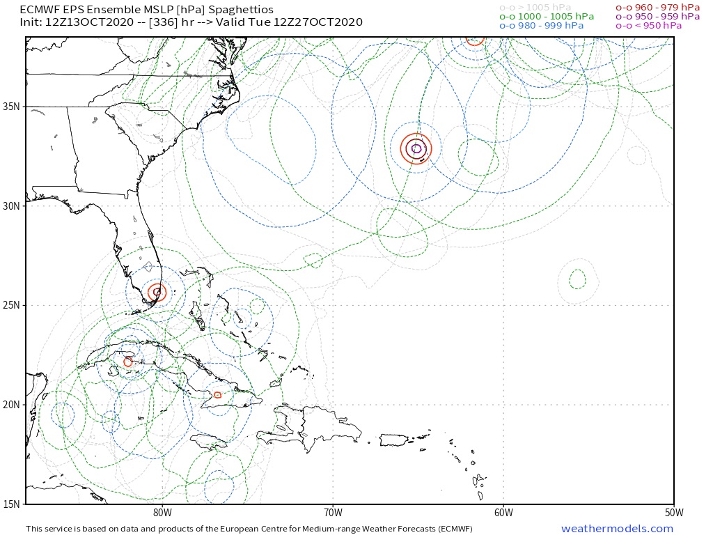
Re: 2020 Global Model Runs Discussion (Out thru day 16)
SFLcane wrote:long range EPS appears to be onboard Clustering near FL.
https://i.postimg.cc/0rg7VTxM/DCA33025-783-B-45-E0-AD40-BBC58-FD555-F7.jpg
Yeah, the 12Z EPS is more active with ~25% (~13) of its members having W Car. genesis. I see 2 of the ~13 active members (of the total of 51 members) that hit S FL. Most miss to the east over the Bahamas while moving NE to ENE. The 2 that hit FL first cross W Cuba.
3 likes
Personal Forecast Disclaimer:
The posts in this forum are NOT official forecasts and should not be used as such. They are just the opinion of the poster and may or may not be backed by sound meteorological data. They are NOT endorsed by any professional institution or storm2k.org. For official information, please refer to the NHC and NWS products.
The posts in this forum are NOT official forecasts and should not be used as such. They are just the opinion of the poster and may or may not be backed by sound meteorological data. They are NOT endorsed by any professional institution or storm2k.org. For official information, please refer to the NHC and NWS products.
-
TheStormExpert
Re: 2020 Global Model Runs Discussion (Out thru day 16)
The GFS and Euro both show completely different 500mb patterns in eight days. You pick and chose which one
You think is right!
Until they both come together on something the future track of the Western Caribbean storm is a crapshot.
https://twitter.com/andyhazelton/status/1316088542569865216
You think is right!
Until they both come together on something the future track of the Western Caribbean storm is a crapshot.
https://twitter.com/andyhazelton/status/1316088542569865216
1 likes
Re: 2020 Global Model Runs Discussion (Out thru day 16)
Shell Mound wrote:LarryWx wrote:The following map of tracks taken for 10/21-31 geneses will be quite useful as regards chances of FL being hit from the W Caribbean. There are two pretty clearcut camps as regards Cuba. Not even one storm on record back to 1851 has crossed Cuba and then landfalled on FL. I was surprised to see this. All of the hits were from storms that either went around Cuba (like Wilma and the 1921 Tampa storm) or originated in the Gulf and all were, interestingly enough, moving ENE or E:
https://i.imgur.com/eTEzU4P.png
Of course that doesn't mean that there won't be an exception this time where one crosses Cuba, especially western Cuba, and then hits FL. I don't see why that isn't a reasonable possibility.
Based on the graph, the location of TCG is significant. The 12Z G(E)FS shows a system forming directly south of Jamaica on 21 October, whereas the 12Z ECMWF/EPS/GFS-P suggest TCG, if any, closer to Nicaragua. According to historical data, systems that formed south of Jamaica during the same timeframe stayed east of 80°W, crossed Jamaica and/or eastern Cuba, and missed the CONUS, whereas a secondary cluster, closer to Central America, tracked much farther west, toward the Yucatán Channel and southern Gulf of Mexico. Therefore, if our prospective system follows the latter solution/cluster (per EC/EPS/GFS-P) instead of the former (per G[E]FS), then it is much more likely to pose a threat to the CONUS. To summarise: TCG south of Jamaica, ~75–80°W, misses CONUS; TCG east of Nicaragua, west of 80°W, poses much greater threat to CONUS. Note, however, that while the EC/EPS/GFS-P suggest a greater threat to the CONUS, they also show a much weaker system than the G(E)FS, suggesting much stronger VWS over the system.
The "east of Nicaragua, west of 80W" region you're describing sounds like the lesser known of the two Hebert Boxes.

7 likes
-
toad strangler

- S2K Supporter
- Posts: 4546
- Joined: Sun Jul 28, 2013 3:09 pm
- Location: Earth
- Contact:
Re: 2020 Global Model Runs Discussion (Out thru day 16)
#notaphantom

0 likes
My Weather Station
https://www.wunderground.com/dashboard/pws/KFLPORTS603
https://www.wunderground.com/dashboard/pws/KFLPORTS603
-
SFLcane
- S2K Supporter
- Posts: 10281
- Age: 48
- Joined: Sat Jun 05, 2010 1:44 pm
- Location: Lake Worth Florida
Re: 2020 Global Model Runs Discussion (Out thru day 16)
Lol... I’ve said the gfs has this one pinned in terms of development. Phantom not so much.
2 likes
-
SFLcane
- S2K Supporter
- Posts: 10281
- Age: 48
- Joined: Sat Jun 05, 2010 1:44 pm
- Location: Lake Worth Florida
Re: 2020 Global Model Runs Discussion (Out thru day 16)
18z gfs has this low spinning up as early as this upcoming Sunday/Monday.
0 likes

Re: 2020 Global Model Runs Discussion (Out thru day 16)
The system stalls just south of Jamaica again on the 18z run.
0 likes
Irene '11 Sandy '12 Hermine '16 5/15/2018 Derecho Fay '20 Isaias '20 Elsa '21 Henri '21 Ida '21
I am only a meteorology enthusiast who knows a decent amount about tropical cyclones. Look to the professional mets, the NHC, or your local weather office for the best information.
I am only a meteorology enthusiast who knows a decent amount about tropical cyclones. Look to the professional mets, the NHC, or your local weather office for the best information.

-
SouthFLTropics

- Category 5
- Posts: 4258
- Age: 50
- Joined: Thu Aug 14, 2003 8:04 am
- Location: Port St. Lucie, Florida
Re: 2020 Global Model Runs Discussion (Out thru day 16)
Quite a big difference in the steering setup between the 12z and the 18z...

0 likes
Fourth Generation Florida Native
Personal Storm History: David 79, Andrew 92, Erin 95, Floyd 99, Irene 99, Frances 04, Jeanne 04, Wilma 05, Matthew 16, Irma 17, Ian 22, Nicole 22, Milton 24
Personal Storm History: David 79, Andrew 92, Erin 95, Floyd 99, Irene 99, Frances 04, Jeanne 04, Wilma 05, Matthew 16, Irma 17, Ian 22, Nicole 22, Milton 24
-
SouthFLTropics
- Category 5
- Posts: 4258
- Age: 50
- Joined: Thu Aug 14, 2003 8:04 am
- Location: Port St. Lucie, Florida
Re: 2020 Global Model Runs Discussion (Out thru day 16)
I don't see how this gets ejected NE across Cuba with no significant trough or weakness there. I would guess the high is going to build in and steer it west again until the next trough comes along.
0 likes
Fourth Generation Florida Native
Personal Storm History: David 79, Andrew 92, Erin 95, Floyd 99, Irene 99, Frances 04, Jeanne 04, Wilma 05, Matthew 16, Irma 17, Ian 22, Nicole 22, Milton 24
Personal Storm History: David 79, Andrew 92, Erin 95, Floyd 99, Irene 99, Frances 04, Jeanne 04, Wilma 05, Matthew 16, Irma 17, Ian 22, Nicole 22, Milton 24
-
toad strangler
- S2K Supporter
- Posts: 4546
- Joined: Sun Jul 28, 2013 3:09 pm
- Location: Earth
- Contact:
Re: 2020 Global Model Runs Discussion (Out thru day 16)
Moving NNE now ... on the 18z GFS
0 likes
My Weather Station
https://www.wunderground.com/dashboard/pws/KFLPORTS603
https://www.wunderground.com/dashboard/pws/KFLPORTS603
-
toad strangler
- S2K Supporter
- Posts: 4546
- Joined: Sun Jul 28, 2013 3:09 pm
- Location: Earth
- Contact:
Re: 2020 Global Model Runs Discussion (Out thru day 16)
We are in post 10 day LA LA land now anyway so the outcome is insignificant here except another huge signal from the GFS for big time Caribbean action.
0 likes
My Weather Station
https://www.wunderground.com/dashboard/pws/KFLPORTS603
https://www.wunderground.com/dashboard/pws/KFLPORTS603
Re: 2020 Global Model Runs Discussion (Out thru day 16)
The 18z GFS has returned to a slow, northerly track with a Cuba landfall around the 25th. Bottoms out at 938 mbar before landfall. If it stalls down in the Caribbean for longer, that’ll probably be a lot lower.
0 likes
Irene '11 Sandy '12 Hermine '16 5/15/2018 Derecho Fay '20 Isaias '20 Elsa '21 Henri '21 Ida '21
I am only a meteorology enthusiast who knows a decent amount about tropical cyclones. Look to the professional mets, the NHC, or your local weather office for the best information.
I am only a meteorology enthusiast who knows a decent amount about tropical cyclones. Look to the professional mets, the NHC, or your local weather office for the best information.
Re: 2020 Global Model Runs Discussion (Out thru day 16)
toad strangler wrote:We are in post 10 day LA LA land now anyway so the outcome is insignificant here except another huge signal from the GFS for big time Caribbean action.
Gyre in 5-6 days, TS in 8 days, Cat 3/4 hurricane in 10 days. Talk about a strong signal. The time frame is one again consistent with this run.
4 likes
Irene '11 Sandy '12 Hermine '16 5/15/2018 Derecho Fay '20 Isaias '20 Elsa '21 Henri '21 Ida '21
I am only a meteorology enthusiast who knows a decent amount about tropical cyclones. Look to the professional mets, the NHC, or your local weather office for the best information.
I am only a meteorology enthusiast who knows a decent amount about tropical cyclones. Look to the professional mets, the NHC, or your local weather office for the best information.
-
SFLcane
- S2K Supporter
- Posts: 10281
- Age: 48
- Joined: Sat Jun 05, 2010 1:44 pm
- Location: Lake Worth Florida
Re: 2020 Global Model Runs Discussion (Out thru day 16)
One thing continues is there could very well be a strong hurricane near the peninsula. We are still talking more then 10 days out and surely things can and will change.
2 likes
-
toad strangler
- S2K Supporter
- Posts: 4546
- Joined: Sun Jul 28, 2013 3:09 pm
- Location: Earth
- Contact:
Re: 2020 Global Model Runs Discussion (Out thru day 16)
SFLcane wrote:One thing continues is there could very well be a strong hurricane near the peninsula. We are still talking more then 10 days out and surely things can and will change.
As always this FAR out .... ensembles will be interesting.
0 likes
My Weather Station
https://www.wunderground.com/dashboard/pws/KFLPORTS603
https://www.wunderground.com/dashboard/pws/KFLPORTS603
-
TheStormExpert
Re: 2020 Global Model Runs Discussion (Out thru day 16)
SFLcane wrote:One thing continues is there could very well be a strong hurricane near the peninsula. We are still talking more then 10 days out and surely things can and will change.
The GFS for the most part has been persistent with this moving mostly due north and over Cuba and The Bahamas out of the Western Caribbean outside of a few runs like today’s 12z. Those seem like outliers at the moment.
0 likes
-
TheStormExpert
Re: 2020 Global Model Runs Discussion (Out thru day 16)
SouthFLTropics wrote:I don't see how this gets ejected NE across Cuba with no significant trough or weakness there. I would guess the high is going to build in and steer it west again until the next trough comes along.
The GFS is notorious for just randomly opening up weaknesses that allow escape routes for storms. Where as the Euro is notorious for overdoing ridges. Just look at the 500mb pattern for both the 12z GFS and Euro for day eight and you’ll see what I mean.
1 likes
Who is online
Users browsing this forum: No registered users and 128 guests