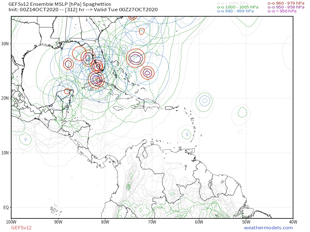
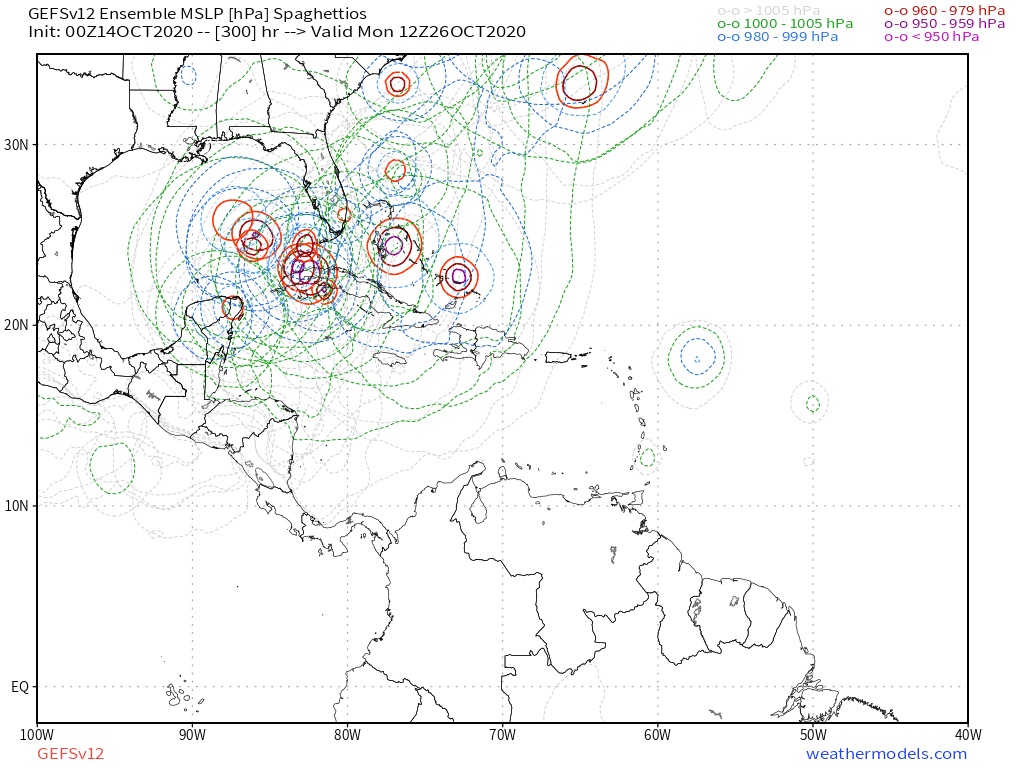
2020 Global Model Runs Discussion (Out thru day 16)

This is the general tropical discussion area. Anyone can take their shot at predicting a storms path.

Moderator: S2k Moderators

Forum rules

The posts in this forum are NOT official forecasts and should not be used as such. They are just the opinion of the poster and may or may not be backed by sound meteorological data. They are NOT endorsed by any professional institution or STORM2K. For official information, please refer to products from the National Hurricane Center and National Weather Service.

Help Support Storm2K
Message
Author
TheStormExpert

Re: 2020 Global Model Runs Discussion (Out thru day 16)

#3501 Postby TheStormExpert » Tue Oct 13, 2020 6:31 pm

mlfreeman wrote:
Shell Mound wrote:
LarryWx wrote:The following map of tracks taken for 10/21-31 geneses will be quite useful as regards chances of FL being hit from the W Caribbean. There are two pretty clearcut camps as regards Cuba. Not even one storm on record back to 1851 has crossed Cuba and then landfalled on FL. I was surprised to see this. All of the hits were from storms that either went around Cuba (like Wilma and the 1921 Tampa storm) or originated in the Gulf and all were, interestingly enough, moving ENE or E:

https://i.imgur.com/eTEzU4P.png

Of course that doesn't mean that there won't be an exception this time where one crosses Cuba, especially western Cuba, and then hits FL. I don't see why that isn't a reasonable possibility.

Based on the graph, the location of TCG is significant. The 12Z G(E)FS shows a system forming directly south of Jamaica on 21 October, whereas the 12Z ECMWF/EPS/GFS-P suggest TCG, if any, closer to Nicaragua. According to historical data, systems that formed south of Jamaica during the same timeframe stayed east of 80°W, crossed Jamaica and/or eastern Cuba, and missed the CONUS, whereas a secondary cluster, closer to Central America, tracked much farther west, toward the Yucatán Channel and southern Gulf of Mexico. Therefore, if our prospective system follows the latter solution/cluster (per EC/EPS/GFS-P) instead of the former (per G[E]FS), then it is much more likely to pose a threat to the CONUS. To summarise: TCG south of Jamaica, ~75–80°W, misses CONUS; TCG east of Nicaragua, west of 80°W, poses much greater threat to CONUS. Note, however, that while the EC/EPS/GFS-P suggest a greater threat to the CONUS, they also show a much weaker system than the G(E)FS, suggesting much stronger VWS over the system.


The "east of Nicaragua, west of 80W" region you're describing sounds like the lesser known of the two Hebert Boxes.
https://upload.wikimedia.org/wikipedia/commons/a/a7/Hebert_boxes.jpg

I think the second Hebert box in the Western Caribbean isn’t as known for storms going on to impacting Florida unlike the first one in the NE Caribbean.
0 likes   

LarryWx
S2K Supporter
S2K Supporter
Posts: 6305
Joined: Sun Sep 07, 2003 2:04 pm
Location: GA

Re: 2020 Global Model Runs Discussion (Out thru day 16)

#3502 Postby LarryWx » Tue Oct 13, 2020 6:34 pm

Here's the good ole Happy Hour GEFS having its say with already one sub 1,000 mb hit on S FL on 10/23:

Image
0 likes   
Personal Forecast Disclaimer:
The posts in this forum are NOT official forecasts and should not be used as such. They are just the opinion of the poster and may or may not be backed by sound meteorological data. They are NOT endorsed by any professional institution or storm2k.org. For official information, please refer to the NHC and NWS products.

User avatar
blp
Category 5
Category 5
Posts: 2840
Age: 46
Joined: Thu Sep 09, 2004 7:51 pm
Location: Miami, FL
Contact:

Re: 2020 Global Model Runs Discussion (Out thru day 16)

#3503 Postby blp » Tue Oct 13, 2020 6:37 pm

Ensembles still in two camps. The one closer to CA mirrors closely with the Euro track. I think 00z will probably swing back west.

Image
3 likes   
The following post is NOT an official forecast and should not be used as such. It is just the opinion of the poster and may or may not be backed by sound meteorological data. It is NOT endorsed by any professional institution including storm2k.org For Official Information please refer to the NHC and NWS products.

User avatar
chaser1
S2K Supporter
S2K Supporter
Posts: 5464
Age: 64
Joined: Sat Oct 15, 2005 5:59 pm
Location: Longwood, Fl

Re: 2020 Global Model Runs Discussion (Out thru day 16)

#3504 Postby chaser1 » Tue Oct 13, 2020 6:42 pm

LarryWx wrote:The following map of tracks taken for 10/21-31 geneses will be quite useful as regards chances of FL being hit from the W Caribbean. There are two pretty clearcut camps as regards Cuba. Not even one storm on record back to 1851 has crossed Cuba and then landfalled on FL. I was surprised to see this. All of the hits were from storms that either went around Cuba (like Wilma and the 1921 Tampa storm) or originated in the Gulf and all were, interestingly enough, moving ENE or E:

https://i.imgur.com/eTEzU4P.png

Of course that doesn't mean that there won't be an exception this time where one crosses Cuba, especially western Cuba, and then hits FL. I don't see why that isn't a reasonable possibility.


Good stuff! Fascinating "date of genesis" comparison data regarding past W. Caribbean storms and their ultimate tracks, especially all having not resulted in a Cuba landfall. On the other hand we all obviously realize that the Atlantic doesn't know how to read a calendar LOL, so I began to wonder what those numbers might look like if a historical review were to include the one week prior and one week after 10/21 - 10/31. Why? Hurricane King 1950 (10/13- 10/20).

I thought it might be interesting to see how many storms DID cross Cuba and hit Florida.... ESPECIALLY during La Nina season events (such as Hurricane King). My rationalization is that La Nina events commonly resulted in greater late season activity which not only expands plausible W. Caribbean genesis, but might better duplicate the background state and storm track
motion especially as it applies to more northward Cuba/Florida landfall events.
1 likes   
Andy D

(For official information, please refer to the NHC and NWS products.)

User avatar
aspen
Category 5
Category 5
Posts: 8818
Joined: Sat Oct 12, 2019 7:10 pm
Location: Connecticut, USA

Re: 2020 Global Model Runs Discussion (Out thru day 16)

#3505 Postby aspen » Tue Oct 13, 2020 6:42 pm

blp wrote:Ensembles still in two camps. The one closer to CA mirrors closely with the Euro track. I think 00z will probably swing back west.

https://i.ibb.co/ZzDXqZz/gfs-ememb-lowlocs-watl-37.png

The Euro probably has too much ridging, while the GFS probably has too much of a weakness. Perhaps the actual track could be between those two camps and something similar to Delta or Wilma, but since this is well over a week out, the steering currents could be much different than they’re currently modeled to be.
2 likes   
Irene '11 Sandy '12 Hermine '16 5/15/2018 Derecho Fay '20 Isaias '20 Elsa '21 Henri '21 Ida '21

I am only a meteorology enthusiast who knows a decent amount about tropical cyclones. Look to the professional mets, the NHC, or your local weather office for the best information.

LarryWx
S2K Supporter
S2K Supporter
Posts: 6305
Joined: Sun Sep 07, 2003 2:04 pm
Location: GA

Re: 2020 Global Model Runs Discussion (Out thru day 16)

#3506 Postby LarryWx » Tue Oct 13, 2020 7:39 pm

I just checked on FL hits on record resulting from late Oct. (10/17-31) W Car or Gulf geneses plus Wilma (since she was still in NW Car 10/21) back to 1851 and found some interesting things:

1. Most recent hit Wilma of 2005 with a MH hit on SW FL. This originated in the W Car and it went around Cuba.

2. Next most recent was 1998's Mitch, which was first in the W Car. He hit SW FL as a TS and also went around Cuba.

3. Assuming I didn't miss one, you then have to go back 48 years to Love of 1950, which formed in the central GOM and then hit the Big Bend as a TS.

4. Then you have to go back 29 years to the MH hit on Tampa in 1921 from one that formed in the W Car and then went around Cuba.

5. Next go back 17 years to the 1904 FL Pan hit of TS #6 that formed in the SW GOM.

6. #9 of 1892 that hit Tampa as a TS after forming in the C GOM

7. #16 of 1887 that hit Tampa as a TS after forming in the E GOM.

8. #7 of 1879 that hit a little N of Tampa as a TS after it formed in the W Car and went around Cuba

9. #7 of 1877 that hit the Big Bend as a TS after forming in the W GOM

10. #5 of 1872 that hit Tampa as a TS after forming in the C GOM.

11. #7 of 1865, which hit S FL as a H after forming in the W Car and going over W Cuba.

12. # 8 of 1859, which hit Tampa as a H after forming in the SW GOM.
-------------------------------------------------------------------------------------------------------------------------------------------------

Analysis:
- 12 storms over 169 years or once every 14 years that hit FL in late Oct after originating in the W Car or GOM
- Out of the 12, only one crossed Cuba at all and it was a whopping 155 years ago! That one from 1865 appears to be the closest analog since 1851 to the current situation if it were to hit FL.
- Origins 7 GOM and 5 W Car
- 2 MH hits, 2 non-major H hits, 8 TS hits
- 6 of 7 GOM geneses hit as TS but only 2 of 5 W Car geneses hit as TS. Both MH hits from W Car.
- Lots of hits on Tampa (5 of the 12)
- Only 5 since 1900 (only one every 24 years) but 7 during 1851-1899 or one every 7 years!
Last edited by LarryWx on Tue Oct 13, 2020 8:11 pm, edited 1 time in total.
8 likes   
Personal Forecast Disclaimer:
The posts in this forum are NOT official forecasts and should not be used as such. They are just the opinion of the poster and may or may not be backed by sound meteorological data. They are NOT endorsed by any professional institution or storm2k.org. For official information, please refer to the NHC and NWS products.

otowntiger
Category 5
Category 5
Posts: 1921
Joined: Tue Aug 31, 2004 7:06 pm

Re: 2020 Global Model Runs Discussion (Out thru day 16)

#3507 Postby otowntiger » Tue Oct 13, 2020 7:54 pm

LarryWx wrote:I just checked on FL hits on record resulting from late Oct. (10/17-31) W Car or Gulf geneses plus Wilma (since she was still in NW Car 10/21) back to 1851 and found some interesting things:

1. Most recent hit Wilma of 2005 with a MH hit on SW FL. This originated in the W Car and it went around Cuba.

2. Next most recent was 1998's Mitch, which was first in the W Car. He hit SW FL as a TS and also went around Cuba.

3. Assuming I didn't miss one, you then have to go back 48 years to Love of 1950, which formed in the central GOM and then hit the Big Bend as a TS.

4. Then you have to go back 29 years to the MH hit on Tampa in 1921 from one that formed in the W Car and then went around Cuba.

5. Next go back 17 years to the 1904 FL Pan hit of TS #6 that formed in the SW GOM.

6. #9 of 1892 that hit Tampa as a TS after forming in the C GOM

7. #16 of 1887 that hit Tampa as a TS after forming in the E GOM.

8. #7 of 1879 that hit a little N of Tampa as a TS after it formed in the W Car and went around Cuba

9. #7 of 1877 that hit the Big Bend as a TS after forming in the W GOM

10. #5 of 1872 that hit Tampa as a TS after forming in the C GOM.

11. #7 of 1865, which hit S FL as a H after forming in the W Car and going over W Cuba.

12. # 8 of 1859, which hit Tampa as a H after forming in the SW GOM.
-------------------------------------------------------------------------------------------------------------------------------------------------

Analysis:
- 12 storms over 169 years or once every 14 years
- Out of the 12, only one crossed Cuba at all and it was a whopping 155 years ago! That one from 1865 appears to be the closest analog since 1851 to the current situation if it were to hit FL.
- Origins 7 GOM and 5 W Car
- 2 MH hits, 2 non-major H hits, 8 TS hits
- 6 of 7 GOM geneses hit as TS but only 2 of 5 W Car geneses hit as TS. Both MH hits from W Car.
- Lots of hits on Tampa (5 of the 12)
- Only 5 since 1900 (only one every 24 years) but 7 during 1851-1899 or one every 7 years!
very interesting stats. Hurricanes generated this time of year in that area are pretty darned rare.
0 likes   

LarryWx
S2K Supporter
S2K Supporter
Posts: 6305
Joined: Sun Sep 07, 2003 2:04 pm
Location: GA

Re: 2020 Global Model Runs Discussion (Out thru day 16)

#3508 Postby LarryWx » Tue Oct 13, 2020 8:10 pm

otowntiger wrote:
LarryWx wrote:I just checked on FL hits on record resulting from late Oct. (10/17-31) W Car or Gulf geneses plus Wilma (since she was still in NW Car 10/21) back to 1851 and found some interesting things:

1. Most recent hit Wilma of 2005 with a MH hit on SW FL. This originated in the W Car and it went around Cuba.

2. Next most recent was 1998's Mitch, which was first in the W Car. He hit SW FL as a TS and also went around Cuba.

3. Assuming I didn't miss one, you then have to go back 48 years to Love of 1950, which formed in the central GOM and then hit the Big Bend as a TS.

4. Then you have to go back 29 years to the MH hit on Tampa in 1921 from one that formed in the W Car and then went around Cuba.

5. Next go back 17 years to the 1904 FL Pan hit of TS #6 that formed in the SW GOM.

6. #9 of 1892 that hit Tampa as a TS after forming in the C GOM

7. #16 of 1887 that hit Tampa as a TS after forming in the E GOM.

8. #7 of 1879 that hit a little N of Tampa as a TS after it formed in the W Car and went around Cuba

9. #7 of 1877 that hit the Big Bend as a TS after forming in the W GOM

10. #5 of 1872 that hit Tampa as a TS after forming in the C GOM.

11. #7 of 1865, which hit S FL as a H after forming in the W Car and going over W Cuba.

12. # 8 of 1859, which hit Tampa as a H after forming in the SW GOM.
-------------------------------------------------------------------------------------------------------------------------------------------------

Analysis:
- 12 storms over 169 years or once every 14 years
- Out of the 12, only one crossed Cuba at all and it was a whopping 155 years ago! That one from 1865 appears to be the closest analog since 1851 to the current situation if it were to hit FL.
- Origins 7 GOM and 5 W Car
- 2 MH hits, 2 non-major H hits, 8 TS hits
- 6 of 7 GOM geneses hit as TS but only 2 of 5 W Car geneses hit as TS. Both MH hits from W Car.
- Lots of hits on Tampa (5 of the 12)
- Only 5 since 1900 (only one every 24 years) but 7 during 1851-1899 or one every 7 years!
very interesting stats. Hurricanes generated this time of year in that area are pretty darned rare.


Keep in mind that these are just the ones that landfalled on FL and are from only LATE Oct geneses in W Car or GOM. There were many more than this from geneses earlier in Oct.
Last edited by LarryWx on Tue Oct 13, 2020 8:51 pm, edited 1 time in total.
2 likes   
Personal Forecast Disclaimer:
The posts in this forum are NOT official forecasts and should not be used as such. They are just the opinion of the poster and may or may not be backed by sound meteorological data. They are NOT endorsed by any professional institution or storm2k.org. For official information, please refer to the NHC and NWS products.

User avatar
aspen
Category 5
Category 5
Posts: 8818
Joined: Sat Oct 12, 2019 7:10 pm
Location: Connecticut, USA

Re: 2020 Global Model Runs Discussion (Out thru day 16)

#3509 Postby aspen » Tue Oct 13, 2020 8:23 pm

Whatever agreement the GFS and GFS-Para had last night is gone. The GFS wants this to go north into Cuba, while the Para has shown the system plowing into CA in the last two runs.
0 likes   
Irene '11 Sandy '12 Hermine '16 5/15/2018 Derecho Fay '20 Isaias '20 Elsa '21 Henri '21 Ida '21

I am only a meteorology enthusiast who knows a decent amount about tropical cyclones. Look to the professional mets, the NHC, or your local weather office for the best information.

User avatar
chaser1
S2K Supporter
S2K Supporter
Posts: 5464
Age: 64
Joined: Sat Oct 15, 2005 5:59 pm
Location: Longwood, Fl

Re: 2020 Global Model Runs Discussion (Out thru day 16)

#3510 Postby chaser1 » Tue Oct 13, 2020 8:47 pm

aspen wrote:Whatever agreement the GFS and GFS-Para had last night is gone. The GFS wants this to go north into Cuba, while the Para has shown the system plowing into CA in the last two runs.


......and this too will change. And then, change again.
5 likes   
Andy D

(For official information, please refer to the NHC and NWS products.)

User avatar
MetroMike
Category 4
Category 4
Posts: 952
Joined: Sun Aug 29, 2004 8:13 pm
Location: Tampa Bay
Contact:

Re: 2020 Global Model Runs Discussion (Out thru day 16)

#3511 Postby MetroMike » Tue Oct 13, 2020 9:19 pm

Hands down I think this is the best model storm in length this season.
0 likes   

SconnieCane
Category 4
Category 4
Posts: 998
Joined: Thu Aug 02, 2018 5:29 pm
Location: Madison, WI

Re: 2020 Global Model Runs Discussion (Out thru day 16)

#3512 Postby SconnieCane » Tue Oct 13, 2020 9:52 pm

TheStormExpert wrote:
mlfreeman wrote:The "east of Nicaragua, west of 80W" region you're describing sounds like the lesser known of the two Hebert Boxes.
https://upload.wikimedia.org/wikipedia/commons/a/a7/Hebert_boxes.jpg

I think the second Hebert box in the Western Caribbean isn’t as known for storms going on to impacting Florida unlike the first one in the NE Caribbean.


Both boxes are intended to delineate storms that, historically, have a higher chance of impacting South Florida after tracking through one of those areas.
0 likes   

MarioProtVI
Category 4
Category 4
Posts: 935
Age: 24
Joined: Sun Sep 29, 2019 7:33 pm
Location: New Jersey

Re: 2020 Global Model Runs Discussion (Out thru day 16)

#3513 Postby MarioProtVI » Wed Oct 14, 2020 12:05 am

00z is nothing less then just WOW. :froze:
0 likes   

caneseddy
Category 5
Category 5
Posts: 1172
Joined: Fri Sep 03, 2004 9:31 pm
Location: Plantation, FL

Re: 2020 Global Model Runs Discussion (Out thru day 16)

#3514 Postby caneseddy » Wed Oct 14, 2020 12:32 am

00z GFS is way west of 18z run; while the 18z run was about 100 miles east of Andros this run brings the TC over or just scraping the western tip of Andros barely missing South Florida

One caveat is that in this run the TC is not as strong as earlier runs. Development begins at 162-174 hours in this run

CMC has the TC meandering East of Yucatán
0 likes   

LarryWx
S2K Supporter
S2K Supporter
Posts: 6305
Joined: Sun Sep 07, 2003 2:04 pm
Location: GA

Re: 2020 Global Model Runs Discussion (Out thru day 16)

#3515 Postby LarryWx » Wed Oct 14, 2020 12:56 am

Holy wow at how active and how far west are several of the 0Z GEFS members!

Image

This likely won't threaten a place like LA this late in the month (though one member gets close), but this run suggests that more of the FL pen and possibly some of the panhandle could be threatened.
Genesis dates are mainly 10/20-4.
0 likes   
Personal Forecast Disclaimer:
The posts in this forum are NOT official forecasts and should not be used as such. They are just the opinion of the poster and may or may not be backed by sound meteorological data. They are NOT endorsed by any professional institution or storm2k.org. For official information, please refer to the NHC and NWS products.

AxaltaRacing24
Category 5
Category 5
Posts: 1753
Age: 25
Joined: Wed Jul 27, 2016 11:14 am
Location: Jupiter, FL

Re: 2020 Global Model Runs Discussion (Out thru day 16)

#3516 Postby AxaltaRacing24 » Wed Oct 14, 2020 1:19 am

LarryWx wrote:Holy wow at how active and how far west are several of the 0Z GEFS members!

https://i.imgur.com/FTDyTQ0.png

This likely won't threaten a place like LA this late in the month (though one member gets close), but this run suggests that more of the FL pen and possibly some of the panhandle could be threatened.
Genesis dates are mainly 10/20-4.

this storm is giving us quite entertaining model runs.
0 likes   

Fancy1001
Category 1
Category 1
Posts: 452
Joined: Thu Jul 16, 2020 10:16 pm

Re: 2020 Global Model Runs Discussion (Out thru day 16)

#3517 Postby Fancy1001 » Wed Oct 14, 2020 2:33 am

The euro is looking interesting.
0 likes   

User avatar
kevin
Category 5
Category 5
Posts: 2586
Age: 26
Joined: Wed Aug 28, 2019 4:35 am

Re: 2020 Global Model Runs Discussion (Out thru day 16)

#3518 Postby kevin » Wed Oct 14, 2020 2:42 am

This has to be the most active late season ensemble I've seen. GFS is still sticking with development on the 20th (+150 hours now). Even though it's not yet within the 90 hour time period, I'd be very surprised if nothing forms from this when there is such a strong signal. If I counted correctly 9/21 members (43%) make landfall in Florida.

0 likes   

User avatar
SFLcane
S2K Supporter
S2K Supporter
Posts: 10163
Age: 47
Joined: Sat Jun 05, 2010 1:44 pm
Location: Lake Worth Florida

Re: 2020 Global Model Runs Discussion (Out thru day 16)

#3519 Postby SFLcane » Wed Oct 14, 2020 4:19 am

Wow really GEFS! :eek:

Image

Image
0 likes   

User avatar
SFLcane
S2K Supporter
S2K Supporter
Posts: 10163
Age: 47
Joined: Sat Jun 05, 2010 1:44 pm
Location: Lake Worth Florida

Re: 2020 Global Model Runs Discussion (Out thru day 16)

#3520 Postby SFLcane » Wed Oct 14, 2020 5:57 am

Deterministic GFS showing the Cuba solution pretty consistently now but we shall see.
0 likes   


Return to “Talkin' Tropics”

Who is online

Users browsing this forum: Hurrilurker, USTropics, WaveBreaking and 49 guests