Indeed hmmm. Could be the gfs is just to quick recurving this NE.
Trough of low pressure in Western Caribbean (Is Invest 95L)
Moderator: S2k Moderators
Forum rules

The posts in this forum are NOT official forecasts and should not be used as such. They are just the opinion of the poster and may or may not be backed by sound meteorological data. They are NOT endorsed by any professional institution or STORM2K. For official information, please refer to products from the National Hurricane Center and National Weather Service.
-
SFLcane

- S2K Supporter

- Posts: 10281
- Age: 48
- Joined: Sat Jun 05, 2010 1:44 pm
- Location: Lake Worth Florida
Re: Possible SW Caribbean Development
Indeed hmmm. Could be the gfs is just to quick recurving this NE.
0 likes
Re: Possible SW Caribbean Development
When Alberta clippers start to appear on the GFS as they are now (snow in Calgary yesterday and likely this weekend), its often a sign the jetstream is far enough south that the Atlantic hurricane season is now limited to the Caribbean. All we can do is keep an eye on it and disgregard the models that don't perform well in similar situations...
0 likes

Re: Possible SW Caribbean Development
If Epsilon doesn’t go west of 60-65W within the next 5 days, like the GFS-Para and 12z Euro are showing, then there would be less of a weakness to draw Zeta north.
0 likes
Irene '11 Sandy '12 Hermine '16 5/15/2018 Derecho Fay '20 Isaias '20 Elsa '21 Henri '21 Ida '21
I am only a meteorology enthusiast who knows a decent amount about tropical cyclones. Look to the professional mets, the NHC, or your local weather office for the best information.
I am only a meteorology enthusiast who knows a decent amount about tropical cyclones. Look to the professional mets, the NHC, or your local weather office for the best information.
Re: Possible SW Caribbean Development
CourierPR wrote:Loveweather12 wrote:You know I’m going to laugh if this storm moves closer or threatens FL & I live in FL. The way most on here are discounting a storm & telling people to come back in June when a Low hasn’t even formed yet frankly surprises me seeing the seniority on This page. Shouldn’t we know by now that storms & models change drastically. Wow.. we can’t let our guard down. Keep saying the so called shields are up & watch a hurricane make landfall in places some are saying won’t happen forever. Wow I’m shocked but maybe it’s just me.
I agree with you. Here we are on the 15th with some predicting a clear miss for Florida from a storm that hasn't formed yet but may form around the 19th or 20th. This and the overuse of the word "bury" boggles my mind.
I agree also, and I mean no disrespect to those who don't. To me, it seems that at this time of year, Florida has the unfortunate distraction, of experiencing cyclones. And the NHC has the SW Carribean highlighted as an area of concern for development. I'm not attempting to convince anyone about this disturbance, or the potential for a storm, not at all. All I am saying is if I were a Florida resident, I would be watching this system closely.
1 likes
-
SFLcane
- S2K Supporter
- Posts: 10281
- Age: 48
- Joined: Sat Jun 05, 2010 1:44 pm
- Location: Lake Worth Florida
Re: Possible SW Caribbean Development
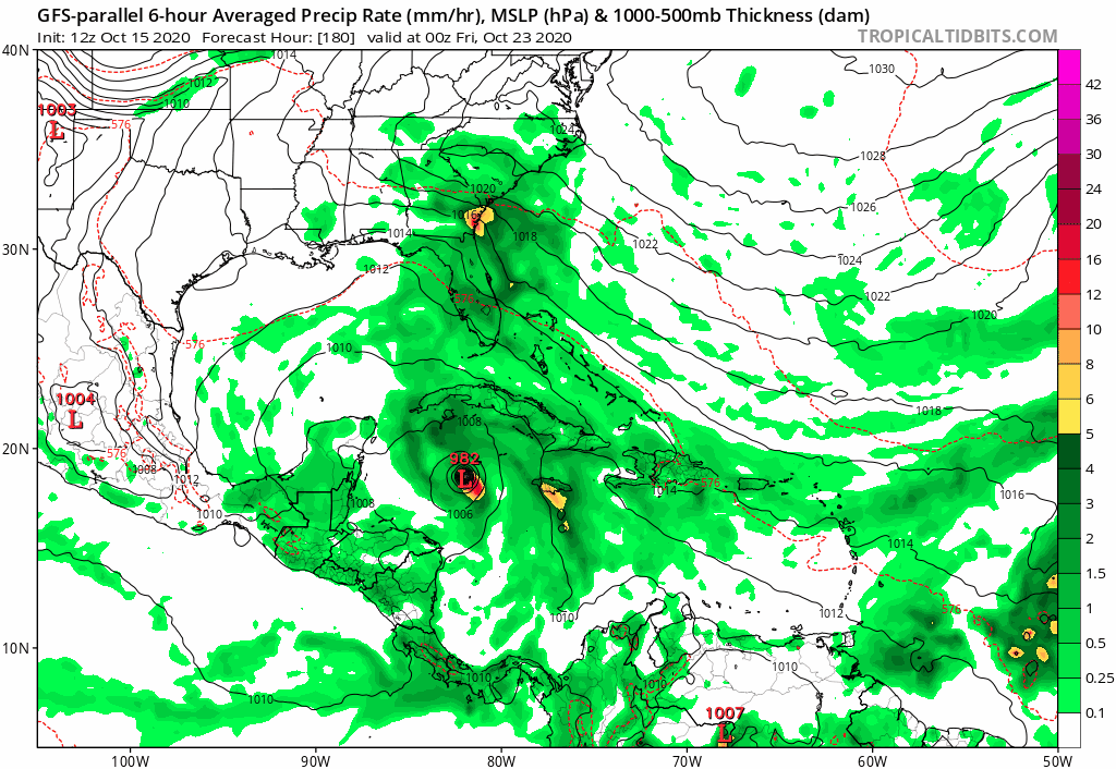
12z Para has a rapidly intensifying hurricane way west. 
4 likes

Re: Possible SW Caribbean Development
SFLcane wrote:12z Para has a rapidly intensifying hurricane way west.
https://i.postimg.cc/t45NNw8V/14-D9-E402-BB28-4-BBA-81-AB-89-D5-FE2840-B3.gif
Notably, it seems to not develop the subtropical system, which instead ends up as an area of enhanced rainfall along the Georgia coast in this image. That probably explains why it has the Caribbean system further west.
If it follows its early pattern, it should eject northeast, but not get fully captured by the front, then move west as the ridge builds back in.
0 likes
-
SouthFLTropics

- Category 5

- Posts: 4258
- Age: 50
- Joined: Thu Aug 14, 2003 8:04 am
- Location: Port St. Lucie, Florida
Re: Possible SW Caribbean Development
Euro seems to have the "circulation" between Honduras and Grand Cayman at 168 hours. However, the signal is very faint. This would put it further west than the GFS.
0 likes
Fourth Generation Florida Native
Personal Storm History: David 79, Andrew 92, Erin 95, Floyd 99, Irene 99, Frances 04, Jeanne 04, Wilma 05, Matthew 16, Irma 17, Ian 22, Nicole 22, Milton 24
Personal Storm History: David 79, Andrew 92, Erin 95, Floyd 99, Irene 99, Frances 04, Jeanne 04, Wilma 05, Matthew 16, Irma 17, Ian 22, Nicole 22, Milton 24
Re: Possible SW Caribbean Development
2 pm NHC outlook has the same percentage, no surprise there. I do see a subtle change in the discussion language on the future movement of the predicted low formation, from a movement of WNW to NW. Y'all may be thinking, whatever bro...but I always look at the language in the forecast discussions, and how they evolve as time passes, to get a sense of a particular systems evolution, and if a threat is growing or imminent. I don't know how to read models, I can honestly say that I don't have any idea what half the things I read on this forum mean, by that I mean the science behind forecasting, but I do the same thing here on 2k. I read what y'all write, and I watch the trends in the posts, from beginning to end, and I always feel informed.
Last edited by underthwx on Thu Oct 15, 2020 1:47 pm, edited 1 time in total.
2 likes
Re: Possible SW Caribbean Development
tomatkins wrote:SFLcane wrote:12z Para has a rapidly intensifying hurricane way west.
https://i.postimg.cc/t45NNw8V/14-D9-E402-BB28-4-BBA-81-AB-89-D5-FE2840-B3.gif
Notably, it seems to not develop the subtropical system, which instead ends up as an area of enhanced rainfall along the Georgia coast in this image. That probably explains why it has the Caribbean system further west.
If it follows its early pattern, it should eject northeast, but not get fully captured by the front, then move west as the ridge builds back in.
The subtropical system does develop, but it’s much further east. Same with the Euro. The ridge seems to “smoosh” the area and force development to the east.
2 likes
Irene '11 Sandy '12 Hermine '16 5/15/2018 Derecho Fay '20 Isaias '20 Elsa '21 Henri '21 Ida '21
I am only a meteorology enthusiast who knows a decent amount about tropical cyclones. Look to the professional mets, the NHC, or your local weather office for the best information.
I am only a meteorology enthusiast who knows a decent amount about tropical cyclones. Look to the professional mets, the NHC, or your local weather office for the best information.
-
SouthFLTropics
- Category 5
- Posts: 4258
- Age: 50
- Joined: Thu Aug 14, 2003 8:04 am
- Location: Port St. Lucie, Florida
Re: Possible SW Caribbean Development
Wonder if the Para is going to go for the zig zag out of the Caribbean again? The last two runs have been crazy... 
2 likes
Fourth Generation Florida Native
Personal Storm History: David 79, Andrew 92, Erin 95, Floyd 99, Irene 99, Frances 04, Jeanne 04, Wilma 05, Matthew 16, Irma 17, Ian 22, Nicole 22, Milton 24
Personal Storm History: David 79, Andrew 92, Erin 95, Floyd 99, Irene 99, Frances 04, Jeanne 04, Wilma 05, Matthew 16, Irma 17, Ian 22, Nicole 22, Milton 24

Re: Possible SW Caribbean Development
I did notice that were the lemon is circled by the NHC is a hair west of where the GFS initializes the potential storm but I wonder if that would affect the track.
0 likes

Re: Possible SW Caribbean Development
So far 12z GFS consistent with its more eastern track. CMC now more ominous with W-NW motion over western Cuba at 10 days. GFS para sorta mimics CMC and does a crazy eight in the eastern GOM. 12z ICON develops 93L in the southern GOM in about a week. Now lets see whats up with the Euro. What is evident is pretty much zilch model consistency other than something is likely to develop. Rinse, wash, repeat.
1 likes
Re: Possible SW Caribbean Development
aspen wrote:tomatkins wrote:SFLcane wrote:12z Para has a rapidly intensifying hurricane way west.
https://i.postimg.cc/t45NNw8V/14-D9-E402-BB28-4-BBA-81-AB-89-D5-FE2840-B3.gif
Notably, it seems to not develop the subtropical system, which instead ends up as an area of enhanced rainfall along the Georgia coast in this image. That probably explains why it has the Caribbean system further west.
If it follows its early pattern, it should eject northeast, but not get fully captured by the front, then move west as the ridge builds back in.
The subtropical system does develop, but it’s much further east. Same with the Euro. The ridge seems to “smoosh” the area and force development to the east.
Thats really a different system. If you look at the GFS you can see more clearly, since it develops both. The one that the GFS-P loses is from an area of disturbed weather that is already evident east of Bermuda (call it A). There is another area of disturbed weather a few hundred miles to the east of that which ALSO develops a little later after interaction with a larger low over the Azores (B).
In the main GFS, A remains strong and eventually more or less merges with B which then allows C to escape.
In the GFS-P A never really takes off and just keeps drifting west. B does strengthen, but without the influence A, it remains far enough away to have no influence on C.
The Euro does develop A, but instead of bringing it southwest, it beings it south or even southeast. It doesn't really develop C - and so it ends up as a weak low in the Gulf.
Last edited by tomatkins on Thu Oct 15, 2020 2:07 pm, edited 2 times in total.
2 likes


Re: Possible SW Caribbean Development
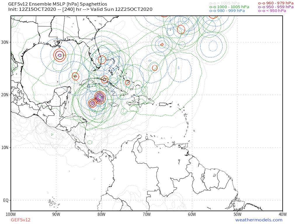
Well that should get everyone's attention.
12z Euro
Sent from my iPhone using Tapatalk
12z Euro
Sent from my iPhone using Tapatalk
4 likes
-
CyclonicFury

- Category 5
- Posts: 2033
- Age: 27
- Joined: Sun Jul 02, 2017 12:32 pm
- Location: NC
- Contact:
Re: Possible SW Caribbean Development
The ECMWF never seems to show TCG in the Caribbean this year in the long range. For Marco, Nana, Gamma and Delta, it never showed much more than a weak closed low until shortly before the time of genesis.
1 likes
NCSU B.S. in Meteorology Class of 2021. Tropical weather blogger at http://www.cyclonicfury.com. My forecasts and thoughts are NOT official, for official forecasts please consult the National Hurricane Center.
-
SFLcane
- S2K Supporter
- Posts: 10281
- Age: 48
- Joined: Sat Jun 05, 2010 1:44 pm
- Location: Lake Worth Florida
Re: Possible SW Caribbean Development
N2FSU wrote:Well that should get everyone's attention.
12z Eurohttps://uploads.tapatalk-cdn.com/20201015/f7f270568b3896ebd1fcef729bf93017.jpg
Sent from my iPhone using Tapatalk
The fact that the euro is west also is interesting.
0 likes
-
TheStormExpert
Re: Possible SW Caribbean Development
I can’t believe there was a time when we used to call the Euro model a so-called “King”! 
Those days seem to be long gone.
Those days seem to be long gone.
0 likes
-
SFLcane
- S2K Supporter
- Posts: 10281
- Age: 48
- Joined: Sat Jun 05, 2010 1:44 pm
- Location: Lake Worth Florida
Re: Possible SW Caribbean Development
CyclonicFury wrote:The ECMWF never seems to show TCG in the Caribbean this year in the long range. For Marco, Nana, Gamma and Delta, it never showed much more than a weak closed low until shortly before the time of genesis.
Yeah it definitely could be missing it.
1 likes
Who is online
Users browsing this forum: cycloneye, pepecool20 and 127 guests