Trough of low pressure in Western Caribbean (Is Invest 95L)
Moderator: S2k Moderators
Forum rules

The posts in this forum are NOT official forecasts and should not be used as such. They are just the opinion of the poster and may or may not be backed by sound meteorological data. They are NOT endorsed by any professional institution or STORM2K. For official information, please refer to products from the National Hurricane Center and National Weather Service.
-
gatorcane

- S2K Supporter

- Posts: 23708
- Age: 48
- Joined: Sun Mar 13, 2005 3:54 pm
- Location: Boca Raton, FL
Re: Possible SW Caribbean Development
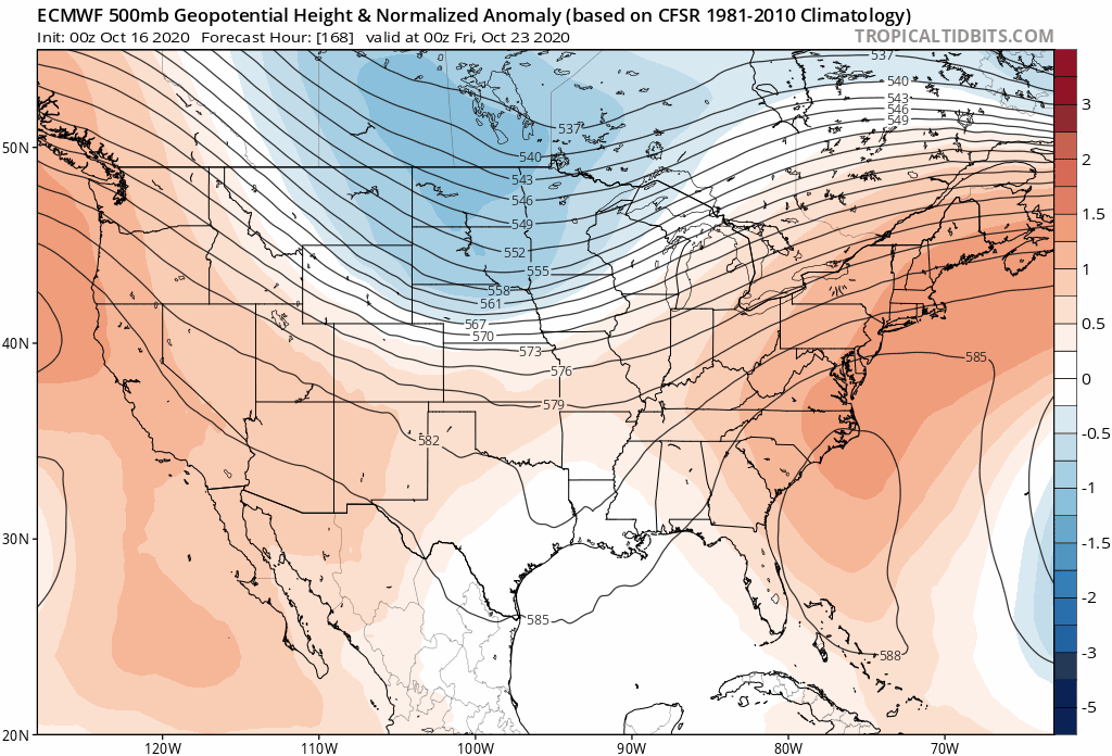
Euro with quite a front which could factor in where the SW Caribbean low ends up: 
0 likes

Re: Possible SW Caribbean Development
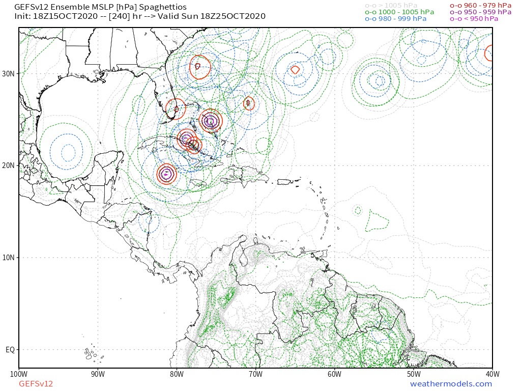
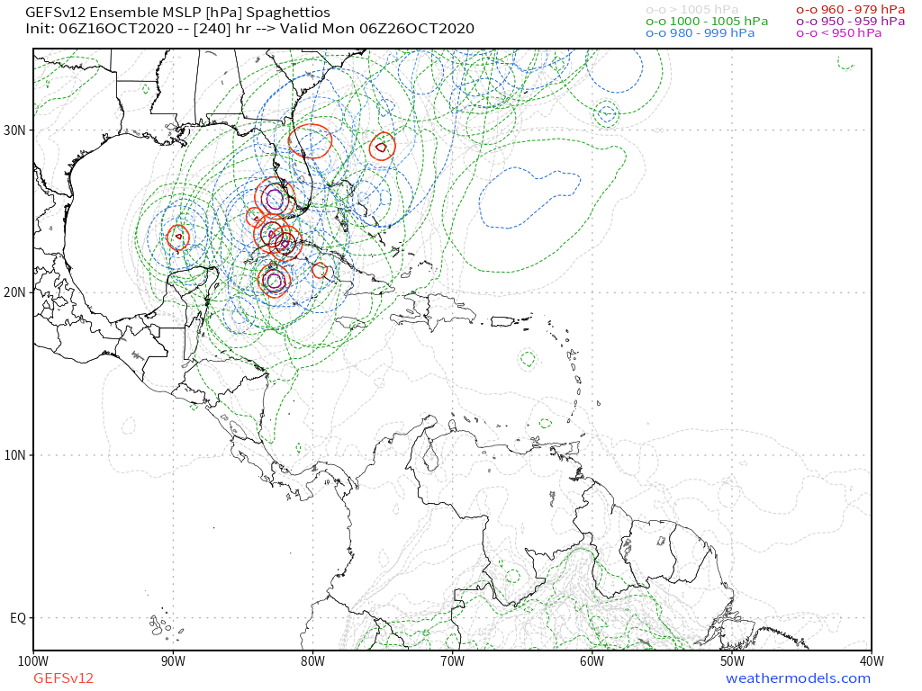
Shell Mound wrote:TheStormExpert wrote:Shell Mound wrote:https://i.postimg.cc/FFgdc2Mk/090-CC96-B-154-E-46-A7-BA59-69-C9-ED7-E1-EEB.jpg
https://i.postimg.cc/tRfyS9sQ/38-D3-AFA2-D9-BD-43-AC-8-BF0-36-D3-AB5099-A8.png
The most recent run (bottom) shows fewer members in the low 950s and more in the mid to upper 950s (mb). So there is a westward, weaker shift.
I’d be more concerned if the GEFS were showing a bunch of sub-950-mb cyclones heading into FL. Threat to FL is increasing, but not strength-wise.
So you're saying a 950-960mb hurricane is not strong?
No, but it’s much better than a Cat-4+ hitting FL, unless the system is large. I would be much more concerned if models were showing a Cat-4+.
I see your point and any slightly good news is welcome, but I don't think we should put a lot of value in intensity this far out. Even in other years when models performed way better, they (espeically the global models) are notoriously bad at predicting intensity this far out.
6 likes
-
SconnieCane
- Category 5

- Posts: 1013
- Joined: Thu Aug 02, 2018 5:29 pm
- Location: Madison, WI
Re: Possible SW Caribbean Development
Shell Mound wrote:TheStormExpert wrote:Shell Mound wrote:https://i.postimg.cc/FFgdc2Mk/090-CC96-B-154-E-46-A7-BA59-69-C9-ED7-E1-EEB.jpg
https://i.postimg.cc/tRfyS9sQ/38-D3-AFA2-D9-BD-43-AC-8-BF0-36-D3-AB5099-A8.png
The most recent run (bottom) shows fewer members in the low 950s and more in the mid to upper 950s (mb). So there is a westward, weaker shift.
I’d be more concerned if the GEFS were showing a bunch of sub-950-mb cyclones heading into FL. Threat to FL is increasing, but not strength-wise.
So you're saying a 950-960mb hurricane is not strong?
No, but it’s much better than a Cat-4+ hitting FL, unless the system is large. I would be much more concerned if models were showing a Cat-4+.
Op models are pretty much useless for resolving intensity of a potential major hurricane that hasn't even formed yet...I don't recall any of them really scoring a coup on Laura or Delta's ultimate peak intensity. Wait till a circulation forms and then run the HWRF on it.
5 likes

Re: Possible SW Caribbean Development
06z GFS is back to showing a major, 00z CMC shows a weak and strung-out system because it makes the gyre huge (there’s a component to it in the EPac on this run).
0 likes
Irene '11 Sandy '12 Hermine '16 5/15/2018 Derecho Fay '20 Isaias '20 Elsa '21 Henri '21 Ida '21
I am only a meteorology enthusiast who knows a decent amount about tropical cyclones. Look to the professional mets, the NHC, or your local weather office for the best information.
I am only a meteorology enthusiast who knows a decent amount about tropical cyclones. Look to the professional mets, the NHC, or your local weather office for the best information.

Re: Possible SW Caribbean Development
I think it might be prudent to take special note of the G/Para over time. Forget who's in the eyewall or exactly how deep the storm is modeled to become. Of note is the models suggestion that overall steering might collapse, thus the squirrely forecast tracks depicted in recent runs. Sure this would have crazy implications for those affected and that's too early to really know. What is important would be an increasing suggestion that a strong storm might be less likely to simply be jettisoned swiftly to the northeast near or remaining south of the Florida peninsula. Model forecasts change on a dime but I'll be curious to see if the GFS, GEM, (and eventually) the EURO begin to display a much slower poleward motion as we move closer to the point of genesis. An outcome such as this would seem to suggest that the long range pattern of greater ridging over the Southeast CONUS that the EURO has been depicting in sharp contrast to the GFS depicting a pattern of sharper troughing in the east, might be the broader scale steering flow that we'll be looking at around Oct 24-26. We're already seeing westward hints from GEFS and frankly I'd be a little surprised if we didn't see the 12Z GFS operational to depict a slower and more south to north oriented track across Cuba and into S. Florida. Still analyzing subtle hints though. It's still to far out to actually begin that model "windshield wiper" stage yet 
EDIT: Just saw Gatorcane's posting of the latest 240 hr. EURO 500mb anomaly. This is actually a dramatic flip toward the GFS solution. No collapse in steering with that flow unless the energy from this trough immediately pulls up leaving weak high pressure over the southeast
EDIT: Just saw Gatorcane's posting of the latest 240 hr. EURO 500mb anomaly. This is actually a dramatic flip toward the GFS solution. No collapse in steering with that flow unless the energy from this trough immediately pulls up leaving weak high pressure over the southeast
3 likes
Andy D
(For official information, please refer to the NHC and NWS products.)
(For official information, please refer to the NHC and NWS products.)
Re: Possible SW Caribbean Development
I was about to say “oh look, the GFS-Para has finally gotten off the drugs”...and then it pulled an Inez and yeeted Zeta west through the Florida straits into the Gulf after crossing Cuba as a Cat 2/3.
3 likes
Irene '11 Sandy '12 Hermine '16 5/15/2018 Derecho Fay '20 Isaias '20 Elsa '21 Henri '21 Ida '21
I am only a meteorology enthusiast who knows a decent amount about tropical cyclones. Look to the professional mets, the NHC, or your local weather office for the best information.
I am only a meteorology enthusiast who knows a decent amount about tropical cyclones. Look to the professional mets, the NHC, or your local weather office for the best information.
Re: Possible SW Caribbean Development
aspen wrote:I was about to say “oh look, the GFS-Para has finally gotten off the drugs”...and then it pulled an Inez and yeeted Zeta west through the Florida straits into the Gulf after crossing Cuba as a Cat 2/3.
Haha, same. I was like 'Wow this actually looks like a realistic run for once GFS-Para good jo- *270 hours frame shows up* wait, hold up what are you doing?!".
Last edited by kevin on Fri Oct 16, 2020 8:19 am, edited 1 time in total.
0 likes
-
Hypercane_Kyle

- Category 5
- Posts: 3465
- Joined: Sat Mar 07, 2015 7:58 pm
- Location: Cape Canaveral, FL
Re: Possible SW Caribbean Development
Good ensemble support.

0 likes
My posts are my own personal opinion, defer to the National Hurricane Center (NHC) and other NOAA products for decision making during hurricane season.

Re: Possible SW Caribbean Development
I'm not so focused on watching the models for track or intensity at this point, but it is remarkable how much consistency we're seeing in regards to the signal down in the Caribbean.
3 likes
Andrew (1992), Irene (1999), Frances (2004), Katrina (2005), Wilma (2005), Fay (2008), Irma (2017), Eta (2020), Ian (2022)
Re: Possible SW Caribbean Development
Nuno wrote:I'm not so focused on watching the models for track or intensity at this point, but it is remarkable how much consistency we're seeing in regards to the signal down in the Caribbean.
Kind of like Delta?....It seemed that the models got tight, or consistent, pretty early in the lifetime of Delta?
1 likes
Re: Possible SW Caribbean Development
Despite once again smoking some really wack drugs, the GFS-Para is much more conservative with Zeta's intensity in the medium range, and that's because, like the 00z CMC and yesterday's 18z GFS, it makes the gyre WAY too big. There's a western lobe that eventually rotates into Central America and dies off, letting the eastern lobe quickly spin up afterwards.

6 likes
Irene '11 Sandy '12 Hermine '16 5/15/2018 Derecho Fay '20 Isaias '20 Elsa '21 Henri '21 Ida '21
I am only a meteorology enthusiast who knows a decent amount about tropical cyclones. Look to the professional mets, the NHC, or your local weather office for the best information.
I am only a meteorology enthusiast who knows a decent amount about tropical cyclones. Look to the professional mets, the NHC, or your local weather office for the best information.
Re: Possible SW Caribbean Development
kevin wrote:aspen wrote:I was about to say “oh look, the GFS-Para has finally gotten off the drugs”...and then it pulled an Inez and yeeted Zeta west through the Florida straits into the Gulf after crossing Cuba as a Cat 2/3.
Haha, same. I was like 'Wow this actually looks like a realistic run for once GFS-Para good jo- *270 hours frame shows up* wait, hold up what are you doing?!".
Yeeted Zeta west?.......what is yeeted?...
0 likes

Re: Possible SW Caribbean Development
Here are the tracks for the Euro. As was mentioned does have more activity and some stronger runs. Also, further west with most of the tracks. Interesting that some of the tracks originate from South Caribbean and some from NW Caribbean.
12z

00z

12z
00z
Last edited by blp on Fri Oct 16, 2020 8:39 am, edited 1 time in total.
1 likes
The following post is NOT an official forecast and should not be used as such. It is just the opinion of the poster and may or may not be backed by sound meteorological data. It is NOT endorsed by any professional institution including storm2k.org For Official Information please refer to the NHC and NWS products.
Re: Possible SW Caribbean Development
underthwx wrote:kevin wrote:aspen wrote:I was about to say “oh look, the GFS-Para has finally gotten off the drugs”...and then it pulled an Inez and yeeted Zeta west through the Florida straits into the Gulf after crossing Cuba as a Cat 2/3.
Haha, same. I was like 'Wow this actually looks like a realistic run for once GFS-Para good jo- *270 hours frame shows up* wait, hold up what are you doing?!".
Yeeted Zeta west?.......what is yeeted?...
Tossed, directed, thrown, etc.
0 likes
Irene '11 Sandy '12 Hermine '16 5/15/2018 Derecho Fay '20 Isaias '20 Elsa '21 Henri '21 Ida '21
I am only a meteorology enthusiast who knows a decent amount about tropical cyclones. Look to the professional mets, the NHC, or your local weather office for the best information.
I am only a meteorology enthusiast who knows a decent amount about tropical cyclones. Look to the professional mets, the NHC, or your local weather office for the best information.
Re: Possible SW Caribbean Development
aspen wrote:underthwx wrote:kevin wrote:
Haha, same. I was like 'Wow this actually looks like a realistic run for once GFS-Para good jo- *270 hours frame shows up* wait, hold up what are you doing?!".
Yeeted Zeta west?.......what is yeeted?...
Tossed, directed, thrown, etc.
Thanks for the definition aspen....it was a sincere question, I wasn't trying to be a smart a**....thanks for not taking it that way...
0 likes
-
Shell Mound
- Category 5
- Posts: 2432
- Age: 33
- Joined: Thu Sep 07, 2017 3:39 pm
- Location: St. Petersburg, FL → Scandinavia
Re: Possible SW Caribbean Development
blp wrote:Here are the tracks for the Euro. As was mentioned does have more activity and some stronger runs. Also, further west with most of the tracks. Interesting that some of the tracks originate from South Caribbean and some from NW Caribbean.
12z
https://i.ibb.co/sFSSmx8/ecens-2020-10-15-12-Z-240-30-292-262-03-12-92-293-573-MSLP-Surface-tracks-lows.png
00z
https://i.ibb.co/jz0hQkk/ecens-2020-10-16-00-Z-240-30-292-262-03-12-92-293-573-MSLP-Surface-tracks-lows.png
Farther west? Hmm, both 12Z and 00Z show most of the tracks staying over or east of the Gulf Stream. May you please point out the west shift? I don’t see it.
0 likes
CVW / MiamiensisWx / Shell Mound
The posts in this forum are NOT official forecasts and should not be used as such. They are just the opinion of the poster and may or may not be backed by sound meteorological data. They are NOT endorsed by any professional institution or STORM2K. For official information, please refer to products from the NHC and NWS.
-
toad strangler

- S2K Supporter
- Posts: 4546
- Joined: Sun Jul 28, 2013 3:09 pm
- Location: Earth
- Contact:
Re: Possible SW Caribbean Development
EURO 2020 
3 likes
My Weather Station
https://www.wunderground.com/dashboard/pws/KFLPORTS603
https://www.wunderground.com/dashboard/pws/KFLPORTS603

Re: Possible SW Caribbean Development
Looks like the tracks stayed the same with most over the Bahamas if anything maybe a bit farther west.
Last edited by boca on Fri Oct 16, 2020 8:52 am, edited 1 time in total.
0 likes

Re: Possible SW Caribbean Development
underthwx wrote:kevin wrote:aspen wrote:I was about to say “oh look, the GFS-Para has finally gotten off the drugs”...and then it pulled an Inez and yeeted Zeta west through the Florida straits into the Gulf after crossing Cuba as a Cat 2/3.
Haha, same. I was like 'Wow this actually looks like a realistic run for once GFS-Para good jo- *270 hours frame shows up* wait, hold up what are you doing?!".
Yeeted Zeta west?.......what is yeeted?...
Yeet, as best I can tell, means something like eject.
GFS-P is definitely in love with the idea that this storm gets left behind by the front and then moves west into the gulf before turning back east and getting caught by the next front.
0 likes
-
AutoPenalti
- Category 5
- Posts: 4091
- Age: 29
- Joined: Mon Aug 17, 2015 4:16 pm
- Location: Ft. Lauderdale, Florida
Re: Possible SW Caribbean Development
tomatkins wrote:underthwx wrote:kevin wrote:
Haha, same. I was like 'Wow this actually looks like a realistic run for once GFS-Para good jo- *270 hours frame shows up* wait, hold up what are you doing?!".
Yeeted Zeta west?.......what is yeeted?...
Yeet, as best I can tell, means something like eject.
GFS-P is definitely in love with the idea that this storm gets left behind by the front and then moves west into the gulf before turning back east and getting caught by the next front.
It's a Gen Z term, I know since, well...
I'm Gen Z and use it a lot... lol.
5 likes
The posts in this forum are NOT official forecasts and should not be used as such. They are just the opinion of the poster and may or may not be backed by sound meteorological data. They are NOT endorsed by any professional institution or STORM2K. For official information, please refer to products from the NHC and NWS.
Model Runs Cheat Sheet:
GFS (5:30 AM/PM, 11:30 AM/PM)
HWRF, GFDL, UKMET, NAVGEM (6:30-8:00 AM/PM, 12:30-2:00 AM/PM)
ECMWF (1:45 AM/PM)
TCVN is a weighted averaged
Who is online
Users browsing this forum: 869MB, JoshwaDone and 94 guests