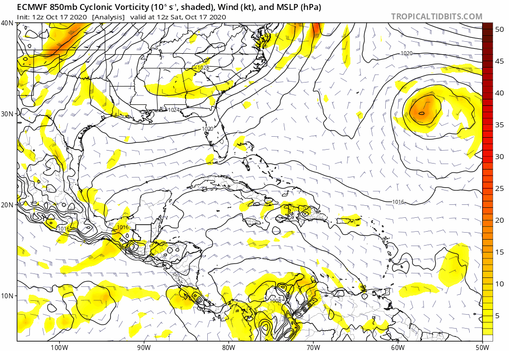
Trough of low pressure in Western Caribbean (Is Invest 95L)

This is the general tropical discussion area. Anyone can take their shot at predicting a storms path.

Moderator: S2k Moderators

Forum rules

The posts in this forum are NOT official forecasts and should not be used as such. They are just the opinion of the poster and may or may not be backed by sound meteorological data. They are NOT endorsed by any professional institution or STORM2K. For official information, please refer to products from the National Hurricane Center and National Weather Service.

Help Support Storm2K
Message
Author
cp79

Re: Possible SW Caribbean Development

#661 Postby cp79 » Sat Oct 17, 2020 2:15 pm

Blown Away wrote:
gatorcane wrote:Euro is like what TC? Continues to show nothing but a weak area of vorticity through 144 hours

https://i.postimg.cc/2Sc4tVJT/ecmwf-uv850-vort-watl-fh0-144.gif


In fairness, the GFS is just starting to pull vorticity together @150 hrs... Euro has not shown much with this area so far...


Does the Euro ever show development with a storm? They didn’t develop Laura, Isaias, Salley or Delta until they actually hit Depression status. In fact, I don’t think they’ve developed a storm all year until they were classified. So throw their model out until it gets a name.
8 likes   

User avatar
DestinHurricane
Category 4
Category 4
Posts: 935
Joined: Tue May 01, 2018 8:05 am
Location: New York, NY

Re: Possible SW Caribbean Development

#662 Postby DestinHurricane » Sat Oct 17, 2020 2:24 pm

cp79 wrote:
Blown Away wrote:
gatorcane wrote:Euro is like what TC? Continues to show nothing but a weak area of vorticity through 144 hours

https://i.postimg.cc/2Sc4tVJT/ecmwf-uv850-vort-watl-fh0-144.gif


In fairness, the GFS is just starting to pull vorticity together @150 hrs... Euro has not shown much with this area so far...


Does the Euro ever show development with a storm? They didn’t develop Laura, Isaias, Salley or Delta until they actually hit Depression status. In fact, I don’t think they’ve developed a storm all year until they were classified. So throw their model out until it gets a name.


The Euro has been genesis blind this year, especially in the western part of the basin. I wouldn't trust euro for handling genesis.
2 likes   
Michael 2018

User avatar
toad strangler
S2K Supporter
S2K Supporter
Posts: 4543
Joined: Sun Jul 28, 2013 3:09 pm
Location: Earth
Contact:

Re: Possible SW Caribbean Development

#663 Postby toad strangler » Sat Oct 17, 2020 2:28 pm

12z GFS did some Day Drinking today. It is Saturday after all. By 18z it will be passed out.
0 likes   

SconnieCane
Category 4
Category 4
Posts: 998
Joined: Thu Aug 02, 2018 5:29 pm
Location: Madison, WI

Re: Possible SW Caribbean Development

#664 Postby SconnieCane » Sat Oct 17, 2020 2:32 pm

cp79 wrote:
Blown Away wrote:
gatorcane wrote:Euro is like what TC? Continues to show nothing but a weak area of vorticity through 144 hours

https://i.postimg.cc/2Sc4tVJT/ecmwf-uv850-vort-watl-fh0-144.gif


In fairness, the GFS is just starting to pull vorticity together @150 hrs... Euro has not shown much with this area so far...


Does the Euro ever show development with a storm? They didn’t develop Laura, Isaias, Salley or Delta until they actually hit Depression status. In fact, I don’t think they’ve developed a storm all year until they were classified. So throw their model out until it gets a name.


I still don't understand why anyone still insists on deferring to the Euro for genesis after this year.
4 likes   

User avatar
cycloneye
Admin
Admin
Posts: 145347
Age: 68
Joined: Thu Oct 10, 2002 10:54 am
Location: San Juan, Puerto Rico

Re: Possible SW Caribbean Development

#665 Postby cycloneye » Sat Oct 17, 2020 2:36 pm

0 likes   
Visit the Caribbean-Central America Weather Thread where you can find at first post web cams,radars
and observations from Caribbean basin members Click Here

User avatar
SFLcane
S2K Supporter
S2K Supporter
Posts: 10163
Age: 47
Joined: Sat Jun 05, 2010 1:44 pm
Location: Lake Worth Florida

Re: Possible SW Caribbean Development

#666 Postby SFLcane » Sat Oct 17, 2020 2:42 pm

One thing for sure the GEFS remains very aggressive near SFL.
0 likes   

User avatar
SFLcane
S2K Supporter
S2K Supporter
Posts: 10163
Age: 47
Joined: Sat Jun 05, 2010 1:44 pm
Location: Lake Worth Florida

Re: Possible SW Caribbean Development

#667 Postby SFLcane » Sat Oct 17, 2020 2:44 pm

0 likes   

underthwx
Category 5
Category 5
Posts: 2360
Joined: Sat Jul 30, 2011 2:14 pm
Location: Brazoria County Texas

Re: Possible SW Caribbean Development

#668 Postby underthwx » Sat Oct 17, 2020 2:51 pm


Maybe it's the Bermuda Triangle?...
0 likes   

User avatar
aspen
Category 5
Category 5
Posts: 8818
Joined: Sat Oct 12, 2019 7:10 pm
Location: Connecticut, USA

Re: Possible SW Caribbean Development

#669 Postby aspen » Sat Oct 17, 2020 2:59 pm

Speed will also matter a lot. If Zeta is faster like the GFS-Para, it’ll be able to sneak out in the opening Epsilon leaves behind. If it’s slower like the GFS, Epsilon will be out of the picture by the time Zeta crosses Cuba, and the ridge will rebuild. There’s a difference of two full days between Zeta’s Cuba landfall in the 12z GFS and GFS-Para runs. Speed will also determine how much time Zeta will have to organize and intensify before Cuba.
3 likes   
Irene '11 Sandy '12 Hermine '16 5/15/2018 Derecho Fay '20 Isaias '20 Elsa '21 Henri '21 Ida '21

I am only a meteorology enthusiast who knows a decent amount about tropical cyclones. Look to the professional mets, the NHC, or your local weather office for the best information.

User avatar
MetroMike
Category 4
Category 4
Posts: 952
Joined: Sun Aug 29, 2004 8:13 pm
Location: Tampa Bay
Contact:

Re: Possible SW Caribbean Development

#670 Postby MetroMike » Sat Oct 17, 2020 3:10 pm

gatorcane wrote:Euro is like what TC? Continues to show nothing but a weak area of vorticity through 144 hours

https://i.postimg.cc/2Sc4tVJT/ecmwf-uv850-vort-watl-fh0-144.gif

I won't even look at the Euro anymore, its been sleeping all season until something develops.
0 likes   

underthwx
Category 5
Category 5
Posts: 2360
Joined: Sat Jul 30, 2011 2:14 pm
Location: Brazoria County Texas

Re: Possible SW Caribbean Development

#671 Postby underthwx » Sat Oct 17, 2020 3:23 pm

chaser1 wrote:In spite of the early and consistent development signals by both the GFS and Para, the bottom line is that both have simply pumped out model solutions based on a storm that at minimum they have jumped the gun on. Perhaps the ICON & UK might suggest a bit of increased model consensus? As bad as the EURO has been this year, any suggestion of significant development from it would lend some greater confidence of a west Caribbean storm likely to form. The fact that NHC has increased their longer range prediction up to 30% suggest an increased likelihood of eventual development but that doesn't mean that the end result will necessarily be anything anything stronger then a weak T.S. My low-confidence guess at this point would err toward a moderate to strong T.S. somewhere between the Yucatan channel & Isle of Pines around Oct. 25-28th


Or for that matter....it may result in a depression, and nothing more?...
0 likes   

User avatar
SouthFLTropics
Category 5
Category 5
Posts: 4236
Age: 50
Joined: Thu Aug 14, 2003 8:04 am
Location: Port St. Lucie, Florida

Re: Possible SW Caribbean Development

#672 Postby SouthFLTropics » Sat Oct 17, 2020 3:36 pm

One thing to keep an eye on for future Euro Ensemble runs... Noticed a few of this afternoons 12z ensembles have the left hook and bend back to the west on them.

Image
2 likes   
Fourth Generation Florida Native

Personal Storm History: David 79, Andrew 92, Erin 95, Floyd 99, Irene 99, Frances 04, Jeanne 04, Wilma 05, Matthew 16, Irma 17, Ian 22, Nicole 22, Milton 24

underthwx
Category 5
Category 5
Posts: 2360
Joined: Sat Jul 30, 2011 2:14 pm
Location: Brazoria County Texas

Re: Possible SW Caribbean Development

#673 Postby underthwx » Sat Oct 17, 2020 3:50 pm

This thread is, at its core...a models thread...on a system that hasn't formed yet...my question is...looking back....can one or more of you share a time...where models have nailed down a system, pre-low formation... strength....track?...I'm sure they have...to be honest...I don't know how to look up information like that...that's where yall come in...I been on here for almost 10 years asking questions...and yall always come through for guys like me that don't have the knowledge alot of you do....
Last edited by underthwx on Sat Oct 17, 2020 4:26 pm, edited 1 time in total.
0 likes   

User avatar
ronjon
Category 5
Category 5
Posts: 4822
Joined: Fri Aug 19, 2005 5:17 pm
Location: Hernando Beach, FL

Re: Possible SW Caribbean Development

#674 Postby ronjon » Sat Oct 17, 2020 3:51 pm

Looks like Euro and UKMET keep the disturbance broad and weak and shunt it more NW into the GOM. GFS may be suffering from some convective feedback which organizes the storm too quickly. If this forms from a broad gyre, more likely to be broad and slow to develop. Also Euro doesn't get 94L even as far west as Bermuda and pretty quickly shunts it NE allowing more ridging in the SW Atlantic. Odds of a very strong major cane seem to be going down with time now.
4 likes   

User avatar
ronjon
Category 5
Category 5
Posts: 4822
Joined: Fri Aug 19, 2005 5:17 pm
Location: Hernando Beach, FL

Re: Possible SW Caribbean Development

#675 Postby ronjon » Sat Oct 17, 2020 3:52 pm

Ensemble runs probably best guide now.
2 likes   

User avatar
mitchell
Category 1
Category 1
Posts: 408
Joined: Wed Mar 19, 2003 8:22 am
Location: Delaware
Contact:

Re: Possible SW Caribbean Development

#676 Postby mitchell » Sat Oct 17, 2020 4:00 pm

Someone in South Florida needs to hurry up and make amends with the 18z GFS model because every afternoon that model smacks South Florida with the storm just parking over top for days, after the other three runs run it off to the northeast.
Last edited by mitchell on Sat Oct 17, 2020 4:01 pm, edited 1 time in total.
0 likes   

User avatar
SouthFLTropics
Category 5
Category 5
Posts: 4236
Age: 50
Joined: Thu Aug 14, 2003 8:04 am
Location: Port St. Lucie, Florida

Re: Possible SW Caribbean Development

#677 Postby SouthFLTropics » Sat Oct 17, 2020 4:01 pm

mitchell wrote:Someone in South Florida needs to hurry up and make amends with the 18z GFS runs because every afternoon that model comes back and smacks South Florida with the storm just parking over top, while the other three runs look like a normal model and run it off to the northeast.


You obviously didn't see the 12z GFS from today... LOL :D
1 likes   
Fourth Generation Florida Native

Personal Storm History: David 79, Andrew 92, Erin 95, Floyd 99, Irene 99, Frances 04, Jeanne 04, Wilma 05, Matthew 16, Irma 17, Ian 22, Nicole 22, Milton 24

User avatar
mitchell
Category 1
Category 1
Posts: 408
Joined: Wed Mar 19, 2003 8:22 am
Location: Delaware
Contact:

Re: Possible SW Caribbean Development

#678 Postby mitchell » Sat Oct 17, 2020 4:02 pm

SouthFLTropics wrote:
mitchell wrote:Someone in South Florida needs to hurry up and make amends with the 18z GFS runs because every afternoon that model comes back and smacks South Florida with the storm just parking over top, while the other three runs look like a normal model and run it off to the northeast.


You obviously didn't see the 12z GFS from today... LOL :D


OOPS you're right...i thought that was the 18 running already. My bad! Of course you could make the argument that happy hour often begins at noon on Saturdays!
Last edited by mitchell on Sat Oct 17, 2020 4:03 pm, edited 1 time in total.
0 likes   

User avatar
Emmett_Brown
Category 5
Category 5
Posts: 1432
Joined: Wed Aug 24, 2005 9:10 pm
Location: Sarasota FL

Re: Possible SW Caribbean Development

#679 Postby Emmett_Brown » Sat Oct 17, 2020 4:03 pm

Yes, the GFS operational runs have been all over the place, but the GEFS ensemble has been consistently calling for development, and there are some members closing off a low as soon as Monday afternoon in the SW Caribbean, so this could be another situation where models are playing catch up with reality. We will see this week... formation is not far out now on the GEFS.
0 likes   

underthwx
Category 5
Category 5
Posts: 2360
Joined: Sat Jul 30, 2011 2:14 pm
Location: Brazoria County Texas

Re: Possible SW Caribbean Development

#680 Postby underthwx » Sat Oct 17, 2020 4:06 pm

mitchell wrote:Someone in South Florida needs to hurry up and make amends with the 18z GFS model because every afternoon that model smacks South Florida with the storm just parking over top for days, after the other three runs run it off to the northeast.


Maybe that GFS is crazy like a fox...one thing I have felt all along...is that whatever becomes of this...will not be moving anywhere too quickly...will a model become erratic with a system that is forecast to be stationary?
0 likes   


Return to “Talkin' Tropics”

Who is online

Users browsing this forum: cheezyWXguy, riapal and 50 guests