Florida Weather
Moderator: S2k Moderators
Forum rules

The posts in this forum are NOT official forecast and should not be used as such. They are just the opinion of the poster and may or may not be backed by sound meteorological data. They are NOT endorsed by any professional institution or STORM2K.
Re: Florida Weather
La Nina definitely stacks the odds in favor of a warmer and drier than normal winter. Between that and our recent stretch of warm winters...it's not bold to bet on another warm winter.
1 likes
-
FlaWeatherDude

- Tropical Storm

- Posts: 115
- Age: 41
- Joined: Wed Oct 10, 2018 2:57 pm
- Location: Orlando, FL.
Re: Florida Weather
Early next week Zeta will most likely get pulled northeast ahead of a significant trough according to accuweather! If it hits Florida it'll be in and out followed by a strong cold front right on it's heels. Then Zeta will grow as it transitions to extratropical and hits the Maritimes! Although the PNA will go positive next week, the NAO should head towards neutral(possibly even neutral positive) as we head towards Halloween.
Before Zeta Epsilon should form and meander in the West Atlantic before taking a northerly turn.
A phase 5/6 MJO favors a deep trough over the East in late Oct. which is why yesterday's 12z GFS run was drunk nevermind an outlier in what it depicted for the 4th week of October!

Before Zeta Epsilon should form and meander in the West Atlantic before taking a northerly turn.
A phase 5/6 MJO favors a deep trough over the East in late Oct. which is why yesterday's 12z GFS run was drunk nevermind an outlier in what it depicted for the 4th week of October!
0 likes
"Windy has wings to fly above the clouds".
-
gatorcane

- S2K Supporter

- Posts: 23708
- Age: 48
- Joined: Sun Mar 13, 2005 3:54 pm
- Location: Boca Raton, FL
Re: Florida Weather
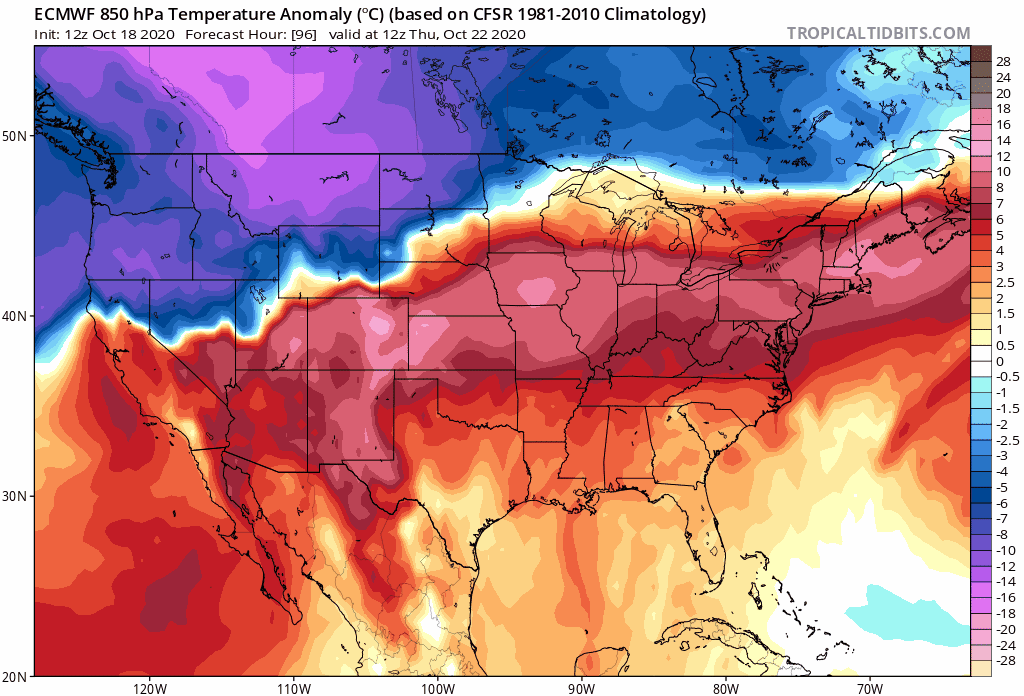
Today’s Euro has a whopper of a front which is on Florida’s doorstep day 10. 
1 likes
-
FlaWeatherDude
- Tropical Storm
- Posts: 115
- Age: 41
- Joined: Wed Oct 10, 2018 2:57 pm
- Location: Orlando, FL.
Re: Florida Weather
gatorcane wrote:Today’s Euro has a whopper of a front which is on Florida’s doorstep day 10.
https://i.postimg.cc/FzYqpKmC/ecmwf-T850a-us-fh96-240.gif
La Nina's pretty much always comes with a late October surprise!
0 likes
"Windy has wings to fly above the clouds".
-
gatorcane
- S2K Supporter
- Posts: 23708
- Age: 48
- Joined: Sun Mar 13, 2005 3:54 pm
- Location: Boca Raton, FL
Re: Florida Weather
FlaWeatherDude wrote:gatorcane wrote:Today’s Euro has a whopper of a front which is on Florida’s doorstep day 10.
https://i.postimg.cc/FzYqpKmC/ecmwf-T850a-us-fh96-240.gif
La Nina's pretty much always comes with a late October surprise!
The 00Z Euro is not early as aggressive. We will see what the 12Z brings.
0 likes
-
FlaWeatherDude
- Tropical Storm
- Posts: 115
- Age: 41
- Joined: Wed Oct 10, 2018 2:57 pm
- Location: Orlando, FL.
Re: Florida Weather
From Larry Cosgrove,
"But a disturbed area around Central America has the chance to organize into a hurricane, perhaps a major designation, in the Caribbean Sea with potential impacts on Cuba. This feature is part of the general threat for a prominent hybrid storm along the East Coast prior to Halloween".
"The risk of a major autumn storm has been bandied about by some of the numerical models for about a week now, centering on the week before Halloween. The central theme would be the merger of tropical and cold-core elements, with a track scenario either right along the Atlantic shoreline or an oceanic route that backflips into the Northeast. The 1991 and 2012 analogs come to mind here, provided there is a storm. Whereas the American model suite seems to have lost the impetus for such an event, the ECMWF series still (somewhat) embraces the topic and indicated a close-to-coast scenario that would be more of a heavy rain situation than wind. Follow the European and UKMET model outcomes, which should be a good resource if the system develops. Climatology favors this outcome, so do not dismiss the idea if the depiction disappears on equation outlines".
https://groups.google.com/g/weatheramerica
Now models are starting to pick up on the Caribbean disturbance developing again and lifting northeast wards so things should get very interesting next week!
0 likes
"Windy has wings to fly above the clouds".
-
TheStormExpert
Re: Florida Weather
FlaWeatherDude wrote:From Larry Cosgrove,
"But a disturbed area around Central America has the chance to organize into a hurricane, perhaps a major designation, in the Caribbean Sea with potential impacts on Cuba. This feature is part of the general threat for a prominent hybrid storm along the East Coast prior to Halloween".
"The risk of a major autumn storm has been bandied about by some of the numerical models for about a week now, centering on the week before Halloween. The central theme would be the merger of tropical and cold-core elements, with a track scenario either right along the Atlantic shoreline or an oceanic route that backflips into the Northeast. The 1991 and 2012 analogs come to mind here, provided there is a storm. Whereas the American model suite seems to have lost the impetus for such an event, the ECMWF series still (somewhat) embraces the topic and indicated a close-to-coast scenario that would be more of a heavy rain situation than wind. Follow the European and UKMET model outcomes, which should be a good resource if the system develops. Climatology favors this outcome, so do not dismiss the idea if the depiction disappears on equation outlines".
https://groups.google.com/g/weatheramerica
Now models are starting to pick up on the Caribbean disturbance developing again and lifting northeast wards so things should get very interesting next week!
What models are you looking at? The GFS dropped development like a rock, and none of the other global models showed sustained development in the Western Caribbean region. Besides that post was from a few days ago when the GFS was development happy.
0 likes
-
toad strangler

- S2K Supporter
- Posts: 4546
- Joined: Sun Jul 28, 2013 3:09 pm
- Location: Earth
- Contact:
Re: Florida Weather
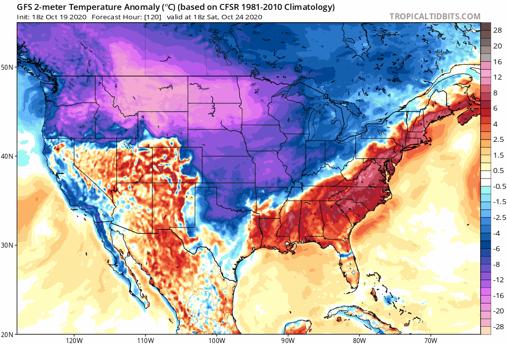
gatorcane wrote:Happy Halloween!
From the good ‘ole “reliable” long-range GFS here:
https://i.postimg.cc/J44bR5N8/gfs-T2ma-us-fh120-258.gif
I'm gonna be camping late next week in Central FL so I'm ready for that S right there provided we survive the frontal passage lol
1 likes
My Weather Station
https://www.wunderground.com/dashboard/pws/KFLPORTS603
https://www.wunderground.com/dashboard/pws/KFLPORTS603
-
FlaWeatherDude
- Tropical Storm
- Posts: 115
- Age: 41
- Joined: Wed Oct 10, 2018 2:57 pm
- Location: Orlando, FL.
Re: Florida Weather
-----
Last edited by FlaWeatherDude on Mon Oct 19, 2020 8:06 pm, edited 1 time in total.
0 likes
"Windy has wings to fly above the clouds".
-
FlaWeatherDude
- Tropical Storm
- Posts: 115
- Age: 41
- Joined: Wed Oct 10, 2018 2:57 pm
- Location: Orlando, FL.
Re: Florida Weather
gatorcane wrote:Happy Halloween!
From the good ‘ole “reliable” long-range GFS here:
https://i.postimg.cc/J44bR5N8/gfs-T2ma-us-fh120-258.gif
If it was the only model showing it, I'd be sceptical. But since other models have it, I'm all in!
0 likes
"Windy has wings to fly above the clouds".
-
TheStormExpert
Re: Florida Weather
gatorcane wrote:Happy Halloween!
From the good ‘ole “reliable” long-range GFS here:
https://i.postimg.cc/J44bR5N8/gfs-T2ma-us-fh120-258.gif
For once I hope the GFS is actually right! Picked up almost a foot of rain here in Palm Beach Gardens since the month began.
0 likes
-
TheStormExpert
Re: Florida Weather
FlaWeatherDude wrote:
If it was the only model showing it, I'd be sceptical. But since other models have it, I'm all in!
What other models are you looking at? The 12z Euro shows the Bermuda High holding firm the day before the GFS has this front passing through the whole state.
0 likes
-
FlaWeatherDude
- Tropical Storm
- Posts: 115
- Age: 41
- Joined: Wed Oct 10, 2018 2:57 pm
- Location: Orlando, FL.
Re: Florida Weather
TheStormExpert wrote:FlaWeatherDude wrote:From Larry Cosgrove,
"But a disturbed area around Central America has the chance to organize into a hurricane, perhaps a major designation, in the Caribbean Sea with potential impacts on Cuba. This feature is part of the general threat for a prominent hybrid storm along the East Coast prior to Halloween".
"The risk of a major autumn storm has been bandied about by some of the numerical models for about a week now, centering on the week before Halloween. The central theme would be the merger of tropical and cold-core elements, with a track scenario either right along the Atlantic shoreline or an oceanic route that backflips into the Northeast. The 1991 and 2012 analogs come to mind here, provided there is a storm. Whereas the American model suite seems to have lost the impetus for such an event, the ECMWF series still (somewhat) embraces the topic and indicated a close-to-coast scenario that would be more of a heavy rain situation than wind. Follow the European and UKMET model outcomes, which should be a good resource if the system develops. Climatology favors this outcome, so do not dismiss the idea if the depiction disappears on equation outlines".
https://groups.google.com/g/weatheramerica
Now models are starting to pick up on the Caribbean disturbance developing again and lifting northeast wards so things should get very interesting next week!
What models are you looking at? The GFS dropped development like a rock, and none of the other global models showed sustained development in the Western Caribbean region. Besides that post was from a few days ago when the GFS was development happy.
Don't be fooled by mid-range crises! Just because models aren't enthused now doesn't mean it won't blossom! Look at Epsilon!
More than likely windshear should be low and instability high with warm STTA extending to great depth so I doubt nothing becomes of the Caribbean disturbance.
0 likes
"Windy has wings to fly above the clouds".
-
FlaWeatherDude
- Tropical Storm
- Posts: 115
- Age: 41
- Joined: Wed Oct 10, 2018 2:57 pm
- Location: Orlando, FL.
Re: Florida Weather
TheStormExpert wrote:FlaWeatherDude wrote:
If it was the only model showing it, I'd be sceptical. But since other models have it, I'm all in!
What other models are you looking at? The 12z Euro shows the Bermuda High holding firm the day before the GFS has this front passing through the whole state.
Both models have a stong cold front plowing through the state by Wednesday and so does the CMC! The Euro been showing this solution for some time!
0 likes
"Windy has wings to fly above the clouds".
-
TheStormExpert
Re: Florida Weather
FlaWeatherDude wrote:TheStormExpert wrote:FlaWeatherDude wrote:From Larry Cosgrove,
"But a disturbed area around Central America has the chance to organize into a hurricane, perhaps a major designation, in the Caribbean Sea with potential impacts on Cuba. This feature is part of the general threat for a prominent hybrid storm along the East Coast prior to Halloween".
"The risk of a major autumn storm has been bandied about by some of the numerical models for about a week now, centering on the week before Halloween. The central theme would be the merger of tropical and cold-core elements, with a track scenario either right along the Atlantic shoreline or an oceanic route that backflips into the Northeast. The 1991 and 2012 analogs come to mind here, provided there is a storm. Whereas the American model suite seems to have lost the impetus for such an event, the ECMWF series still (somewhat) embraces the topic and indicated a close-to-coast scenario that would be more of a heavy rain situation than wind. Follow the European and UKMET model outcomes, which should be a good resource if the system develops. Climatology favors this outcome, so do not dismiss the idea if the depiction disappears on equation outlines".
https://groups.google.com/g/weatheramerica
Now models are starting to pick up on the Caribbean disturbance developing again and lifting northeast wards so things should get very interesting next week!
What models are you looking at? The GFS dropped development like a rock, and none of the other global models showed sustained development in the Western Caribbean region. Besides that post was from a few days ago when the GFS was development happy.
Don't be fooled by mid-range crises! Just because models aren't enthused now doesn't mean it won't blossom! Look at Epsilon!
More than likely windshear should be low and instability high with warm STTA extending to great depth so I doubt nothing becomes of the Caribbean disturbance.I think models are having a hard time forecasting the monsoon gyre in the West Carribean that's all.
You're comparing two completely different things? The teleconnections such as the NAO, and PNA don't really support such a cold front moving through Florida anytime soon. You need a +PNA along with the -NAO. A -PNA creates more West Atlantic ridging such as the Bermuda High.


0 likes
Re: Florida Weather
we may be going from model storm season to model front season. don't buy into long range cold fronts. they often fail just like this past weekend's did. the CPC outlooks are tilting warm...although the 8-14 day is less warm it still resides on the warm side of normal. if anything i expect our loyal, dependable cold season friend...the southeast ridge..to show up.
1 likes
-
gatorcane
- S2K Supporter
- Posts: 23708
- Age: 48
- Joined: Sun Mar 13, 2005 3:54 pm
- Location: Boca Raton, FL
Re: Florida Weather
Don't know about you all but it seems rainy season is going strong here across Florida particularly Central and Southern Florida. I am ready for it to end to be honest. Seems all it does is rain, rain, and more rain. Of course I have a feeling we will be wishing for rain as we head into this year's La Nina winter.
0 likes
-
gatorcane
- S2K Supporter
- Posts: 23708
- Age: 48
- Joined: Sun Mar 13, 2005 3:54 pm
- Location: Boca Raton, FL
Re: Florida Weather
Relief is on the way from this never-ending rainy season! NWS Miami snippet:
https://forecast.weather.gov/product.ph ... glossary=0
Monday through Wednesday
A 500mb ridge of higher pressure gradually builds over the
region, with South Florida on the eastern periphery of this
feature. This orientation should induce synoptic scale subsidence,
which may suppress widespread storm coverage. The GFS/ECMWF are
in relative agreement that a slightly cooler and drier airmass
appears to advect into the region, with modest ENE flow near the
surface. PoPs are low through this period, with values generally
no greater than 25. This should also bring a more seasonable air
mass to the area, along with a drying trend.
https://forecast.weather.gov/product.ph ... glossary=0
0 likes