AL, 95, 2020102306, , BEST, 0, 188N, 813W, 25, 1008, LO, 34, NEQ, 0, 0, 0, 0, 1011, 150, 50, 0, 0, L, 0, , 0, 0, INVEST, M, 0, , 0, 0, 0, 0, genesis-num, 061, SPAWNINVEST, al782020 to al952020,
ATL: ZETA - Post-Tropical - Discussion
Moderator: S2k Moderators
-
Nancy Smar

- Category 5

- Posts: 1081
- Age: 25
- Joined: Wed Aug 16, 2017 10:03 pm
ATL: ZETA - Post-Tropical - Discussion
Last edited by Nancy Smar on Sun Oct 25, 2020 1:12 am, edited 2 times in total.
0 likes
-
northjaxpro

- S2K Supporter

- Posts: 8900
- Joined: Mon Sep 27, 2010 11:21 am
- Location: Jacksonville, FL
Re: ATL: INVEST 95L - Discussion
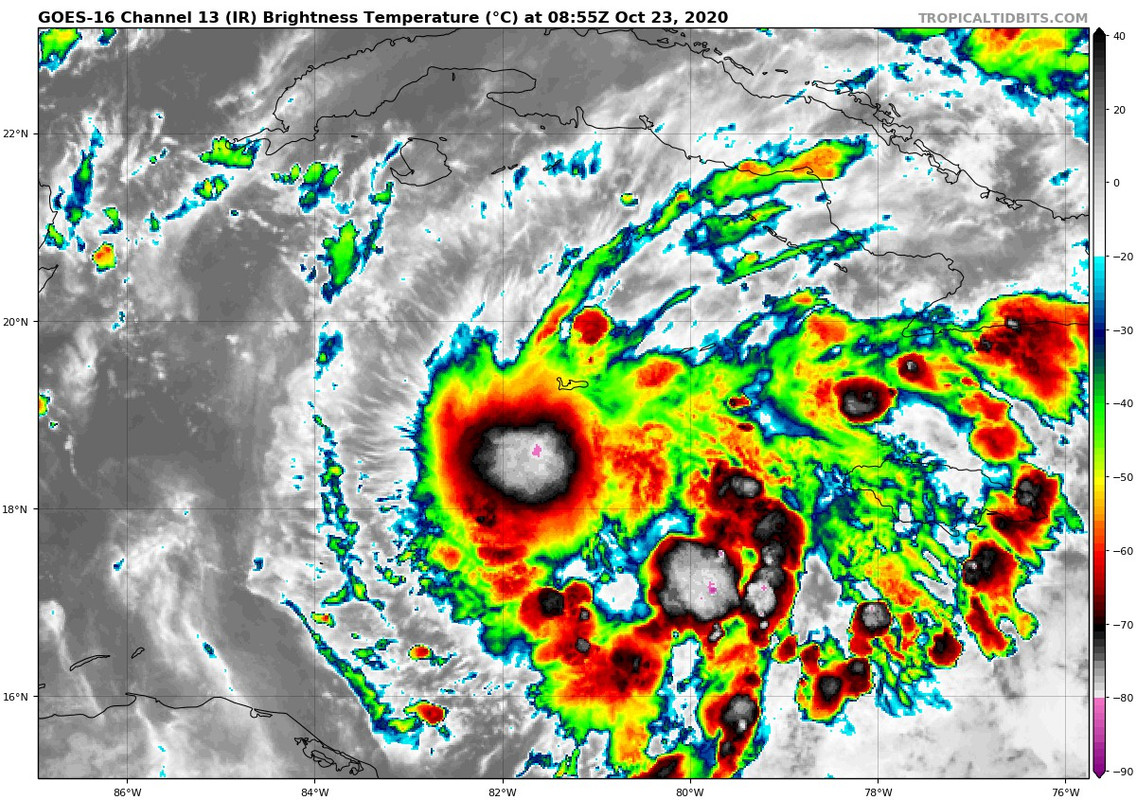
Looks as if 95L could very well be a significant weather maker for The Keys and South Florida over the next few days. 95L is really beginning to pull together early this morning as convection appears to have fired up near the developing LLC, which appears to be very near Grand Cayman Island at this early hour. Potential fòr more heavy rainfall for Cayman Islands, and Cuba. Also, potential of getting yet another named storm (Zeta), especially as the system reaches the Florida Straits region.
Conditions are decent for development with an anticyclone moving in tandum with 95L and warm ssts across the area off Cuba and over the Florida Straits.
Conditions are decent for development with an anticyclone moving in tandum with 95L and warm ssts across the area off Cuba and over the Florida Straits.
2 likes
NEVER, EVER SAY NEVER in the tropics and weather in general, and most importantly, with life itself!!
________________________________________________________________________________________
Fay 2008 Beryl 2012 Debby 2012 Colin 2016 Hermine 2016 Julia 2016 Matthew 2016 Irma 2017 Dorian 2019
________________________________________________________________________________________
Fay 2008 Beryl 2012 Debby 2012 Colin 2016 Hermine 2016 Julia 2016 Matthew 2016 Irma 2017 Dorian 2019
-
SFLcane

- S2K Supporter
- Posts: 10281
- Age: 48
- Joined: Sat Jun 05, 2010 1:44 pm
- Location: Lake Worth Florida
Re: ATL: INVEST 95L - Discussion
Models could very well be asleep at the wheel on this one. Surely looks like a developing tc to me.
8 likes
-
Kingarabian

- S2K Supporter
- Posts: 16365
- Joined: Sat Aug 08, 2009 3:06 am
- Location: Honolulu, Hawaii
-
Kingarabian
- S2K Supporter
- Posts: 16365
- Joined: Sat Aug 08, 2009 3:06 am
- Location: Honolulu, Hawaii
Re: ATL: INVEST 95L - Discussion
SFLcane wrote:Models could very well be asleep at the wheel on this one. Surely looks like a developing tc to me.
[url]https://i.postimg.cc/3x0PcBPP/FC81-BBFA-4-A4-A-4-D45-BB81-B6-DAD6662-E7-E.jpg[/rl]
I mean this satellite presentation is significantly better than what the models are showing
2 likes
RIP Kobe Bryant
-
northjaxpro
- S2K Supporter
- Posts: 8900
- Joined: Mon Sep 27, 2010 11:21 am
- Location: Jacksonville, FL
Re: ATL: INVEST 95L - Discussion
Kingarabian wrote:SFLcane wrote:Models could very well be asleep at the wheel on this one. Surely looks like a developing tc to me.
[url]https://i.postimg.cc/3x0PcBPP/FC81-BBFA-4-A4-A-4-D45-BB81-B6-DAD6662-E7-E.jpg[/rl]
I mean this satellite presentation is significantly better than what the models are showing
I agree. The system has really pulled together just over the last 8-12 hours. 95L just may be in the process of really ramping up. We have to pay attention to this very carefully. I think the models may be a bit slow with how 95L is coming together quickly.
Last edited by northjaxpro on Fri Oct 23, 2020 4:43 am, edited 2 times in total.
3 likes
NEVER, EVER SAY NEVER in the tropics and weather in general, and most importantly, with life itself!!
________________________________________________________________________________________
Fay 2008 Beryl 2012 Debby 2012 Colin 2016 Hermine 2016 Julia 2016 Matthew 2016 Irma 2017 Dorian 2019
________________________________________________________________________________________
Fay 2008 Beryl 2012 Debby 2012 Colin 2016 Hermine 2016 Julia 2016 Matthew 2016 Irma 2017 Dorian 2019
-
SFLcane
- S2K Supporter
- Posts: 10281
- Age: 48
- Joined: Sat Jun 05, 2010 1:44 pm
- Location: Lake Worth Florida
Re: ATL: INVEST 95L - Discussion
Kingarabian wrote:HMON/HWRF will be interesting.
Icon has a 978mb hurricane near tip of Cuba.
2 likes
-
northjaxpro
- S2K Supporter
- Posts: 8900
- Joined: Mon Sep 27, 2010 11:21 am
- Location: Jacksonville, FL
Re: ATL: INVEST 95L - Discussion
SFLcane wrote:Kingarabian wrote:HMON/HWRF will be interesting.
Icon has a 978mb hurricane near tip of Cuba.
Yeah, I was just getting ready to mention this. ICON really intensifies it on its approach to Cuba. It also very slowly moves 95L to off the western tip of Cuba over the next couple of days as well.
2 likes
NEVER, EVER SAY NEVER in the tropics and weather in general, and most importantly, with life itself!!
________________________________________________________________________________________
Fay 2008 Beryl 2012 Debby 2012 Colin 2016 Hermine 2016 Julia 2016 Matthew 2016 Irma 2017 Dorian 2019
________________________________________________________________________________________
Fay 2008 Beryl 2012 Debby 2012 Colin 2016 Hermine 2016 Julia 2016 Matthew 2016 Irma 2017 Dorian 2019
-
SFLcane
- S2K Supporter
- Posts: 10281
- Age: 48
- Joined: Sat Jun 05, 2010 1:44 pm
- Location: Lake Worth Florida
Re: ATL: INVEST 95L - Discussion
6 likes
-
northjaxpro
- S2K Supporter
- Posts: 8900
- Joined: Mon Sep 27, 2010 11:21 am
- Location: Jacksonville, FL
Re: ATL: INVEST 95L - Discussion
06Z ICON run finishes by intensifying 95L to 970 mb Cat 2 tropical cyclone in 120 hours over the Eastern GOM.
Last edited by northjaxpro on Fri Oct 23, 2020 5:06 am, edited 1 time in total.
2 likes
NEVER, EVER SAY NEVER in the tropics and weather in general, and most importantly, with life itself!!
________________________________________________________________________________________
Fay 2008 Beryl 2012 Debby 2012 Colin 2016 Hermine 2016 Julia 2016 Matthew 2016 Irma 2017 Dorian 2019
________________________________________________________________________________________
Fay 2008 Beryl 2012 Debby 2012 Colin 2016 Hermine 2016 Julia 2016 Matthew 2016 Irma 2017 Dorian 2019
-
Kingarabian
- S2K Supporter
- Posts: 16365
- Joined: Sat Aug 08, 2009 3:06 am
- Location: Honolulu, Hawaii
Re: ATL: INVEST 95L - Discussion
Wow I hope the 06z ICON is not the beginning of a bad trend...
0 likes
RIP Kobe Bryant
-
northjaxpro
- S2K Supporter
- Posts: 8900
- Joined: Mon Sep 27, 2010 11:21 am
- Location: Jacksonville, FL
Re: ATL: INVEST 95L - Discussion
This thread is about to really explode once the peeps wake up to this development for sure!
2 likes
NEVER, EVER SAY NEVER in the tropics and weather in general, and most importantly, with life itself!!
________________________________________________________________________________________
Fay 2008 Beryl 2012 Debby 2012 Colin 2016 Hermine 2016 Julia 2016 Matthew 2016 Irma 2017 Dorian 2019
________________________________________________________________________________________
Fay 2008 Beryl 2012 Debby 2012 Colin 2016 Hermine 2016 Julia 2016 Matthew 2016 Irma 2017 Dorian 2019
-
northjaxpro
- S2K Supporter
- Posts: 8900
- Joined: Mon Sep 27, 2010 11:21 am
- Location: Jacksonville, FL
Re: ATL: INVEST 95L - Discussion
I think most of you all I hope have learned a valuable lesson over these past couple of weeks to not fully trust the GFS with tropical cyclone genesis right now. In fact, most of the reliable models have fared poorly recently wirh regards to the Caribbean development up until now. Heck, overall they have generally struggled all season long with tropical cyclone development throughout the N. ATL basin.
I would definitely not downplay the ICON, like some people on this forum does at times. Personally, the ICON in this instance just may be onto something with potential rapid development, given the decent upper level conditions and the warm ssts 95L will be traversing over during the short to medium term.
I would definitely not downplay the ICON, like some people on this forum does at times. Personally, the ICON in this instance just may be onto something with potential rapid development, given the decent upper level conditions and the warm ssts 95L will be traversing over during the short to medium term.
2 likes
NEVER, EVER SAY NEVER in the tropics and weather in general, and most importantly, with life itself!!
________________________________________________________________________________________
Fay 2008 Beryl 2012 Debby 2012 Colin 2016 Hermine 2016 Julia 2016 Matthew 2016 Irma 2017 Dorian 2019
________________________________________________________________________________________
Fay 2008 Beryl 2012 Debby 2012 Colin 2016 Hermine 2016 Julia 2016 Matthew 2016 Irma 2017 Dorian 2019
-
SconnieCane
- Category 5
- Posts: 1013
- Joined: Thu Aug 02, 2018 5:29 pm
- Location: Madison, WI
Re: ATL: INVEST 95L - Discussion
SFLcane wrote:Another fail by the models...
Well, in fairness we don't have a TC yet...but it's certainly interesting.
0 likes

Re: ATL: INVEST 95L - Discussion
Appears that a piece of energy shears off to the NE in a few days but the main low center stays near western cuba and then slowly drifts off to the NW. While ICON really only develops it strongly, recent GFS now starting to at least weakly develop it and move it eventually up toward the northern gulf coast. Will be watching this one carefully on the west coast of Florida.
0 likes
-
gatorcane

- S2K Supporter
- Posts: 23708
- Age: 48
- Joined: Sun Mar 13, 2005 3:54 pm
- Location: Boca Raton, FL
Re: ATL: INVEST 95L - Discussion
Certainly looks a bit suspicious down there, models might be in catchup mode on this:

2 likes
-
Blown Away

- S2K Supporter
- Posts: 10253
- Joined: Wed May 26, 2004 6:17 am
Re: ATL: INVEST 95L - Discussion

Starting to get the look.
4 likes
Hurricane Eye Experience: David 79, Irene 99, Frances 04, Jeanne 04, Wilma 05… Hurricane Brush Experience: Andrew 92, Erin 95, Floyd 99, Matthew 16, Irma 17, Ian 22, Nicole 22…

Re: ATL: INVEST 95L - Discussion
ZCZC MIATWOAT ALL
TTAA00 KNHC DDHHMM
Tropical Weather Outlook
NWS National Hurricane Center Miami FL
800 AM EDT Fri Oct 23 2020
For the North Atlantic...Caribbean Sea and the Gulf of Mexico:
The National Hurricane Center is issuing advisories on Hurricane
Epsilon, located over the west-central Atlantic a couple of hundred
miles northeast of Bermuda.
1. A broad area of low pressure located near Grand Cayman Island is
producing a large area of showers and thunderstorms mainly east and
south of the center. This system has become much better organized
since yesterday, and a tropical depression could form during the
next couple of days while the low moves slowly toward the northwest.
This system is now anticipated to move near western Cuba this
weekend and move slowly across the southeastern Gulf of Mexico by
early next week. Regardless of development, locally heavy rainfall
will be possible over portions of the Cayman Islands, Cuba,
southern Florida and the Keys, and the northwestern Bahamas through
the weekend.
* Formation chance through 48 hours...medium...50 percent.
* Formation chance through 5 days...medium...60 percent.
Forecaster Blake/Papin
0 likes
Who is online
Users browsing this forum: No registered users and 77 guests