Where ever it goes don’t expect anything too significant.
https://twitter.com/cyclonicwx/status/1319650565220126720
ATL: ZETA - Post-Tropical - Discussion
Moderator: S2k Moderators
-
AutoPenalti
- Category 5

- Posts: 4091
- Age: 29
- Joined: Mon Aug 17, 2015 4:16 pm
- Location: Ft. Lauderdale, Florida
Re: ATL: INVEST 95L - Discussion
TheStormExpert wrote:Where ever it goes don’t expect anything too significant.
https://twitter.com/cyclonicwx/status/1319650565220126720
Shear is set to relax as the anti-cyclone moves in tandem with 95L, not sure how much I buy this.
0 likes
The posts in this forum are NOT official forecasts and should not be used as such. They are just the opinion of the poster and may or may not be backed by sound meteorological data. They are NOT endorsed by any professional institution or STORM2K. For official information, please refer to products from the NHC and NWS.
Model Runs Cheat Sheet:
GFS (5:30 AM/PM, 11:30 AM/PM)
HWRF, GFDL, UKMET, NAVGEM (6:30-8:00 AM/PM, 12:30-2:00 AM/PM)
ECMWF (1:45 AM/PM)
TCVN is a weighted averaged

Re: ATL: INVEST 95L - Discussion
TheStormExpert wrote:Where ever it goes don’t expect anything too significant.
https://twitter.com/cyclonicwx/status/1319650565220126720
Perhaps if this system heads more north and west towards the upper Gulf coast, where shear would likely affect it. Way too soon to make these assumptions however, this storm would be better off if it stays on the eastern side (heading north and northeast into SW Florida or the straits instead of NW north of 27-28 degrees north).
Given the current organizational trends, we could have a hurricane by Sunday IMO.
3 likes
Georges '98, Irene '99, Frances '04, Jeanne '04, Katrina '05, Wilma '05, Gustav '08, Isaac '12, Matthew '16, Florence '18, Michael '18, Ian '22

Re: ATL: INVEST 95L - Discussion
TheStormExpert wrote:
For now, but look what awaits it if and when it begins to lift north. Probably why the GFS dropped development days ago.
Most models now meander the system for 3 days just south of Cuba - don't see UL winds hindering it anytime soon.
0 likes
-
cycloneye

- Admin

- Posts: 149505
- Age: 69
- Joined: Thu Oct 10, 2002 10:54 am
- Location: San Juan, Puerto Rico
Re: ATL: INVEST 95L - Discussion
aspen wrote:FINALLY, this is an Invest and we can put that 1,161 post thread out of its misery. Looking pretty good this morning.
Will it reach 392 pages to surpass the Laura one? Depends on how the disturbance behaves and tracks.What I mean is if it tracks thru Cuba and the Bahamas and then to the Western Atlantic no, but if it moves to the Fla straits or SE GOM and turns into a bonifide cyclone, then things will turn very active.
0 likes
Visit the Caribbean-Central America Weather Thread where you can find at first post web cams,radars
and observations from Caribbean basin members Click Here
and observations from Caribbean basin members Click Here
-
ElectricStorm

- Category 5
- Posts: 5147
- Age: 25
- Joined: Tue Aug 13, 2019 11:23 pm
- Location: Norman, OK
Re: ATL: INVEST 95L - Discussion
Starting to get a little bit concerned about this one, especially if that anticyclone tracks with it, which I think it's supposed to...
0 likes
B.S Meteorology, University of Oklahoma '25
Please refer to the NHC, NWS, or SPC for official information.
Please refer to the NHC, NWS, or SPC for official information.
-
SouthFLTropics

- Category 5
- Posts: 4258
- Age: 50
- Joined: Thu Aug 14, 2003 8:04 am
- Location: Port St. Lucie, Florida
Re: ATL: INVEST 95L - Discussion
Just looking at satellite, I think this thing is going to set up shop a little bit south and east of where the models are showing. Have they tasked any recon yet for this, because we really need to see what's going on down there?
3 likes
Fourth Generation Florida Native
Personal Storm History: David 79, Andrew 92, Erin 95, Floyd 99, Irene 99, Frances 04, Jeanne 04, Wilma 05, Matthew 16, Irma 17, Ian 22, Nicole 22, Milton 24
Personal Storm History: David 79, Andrew 92, Erin 95, Floyd 99, Irene 99, Frances 04, Jeanne 04, Wilma 05, Matthew 16, Irma 17, Ian 22, Nicole 22, Milton 24
-
Aric Dunn
- Category 5
- Posts: 21238
- Age: 43
- Joined: Sun Sep 19, 2004 9:58 pm
- Location: Ready for the Chase.
- Contact:
Re: ATL: INVEST 95L - Discussion
Couple more hours of images added..
trying to develop a proto curved inflow band. MLC to the south appears to be weakening as convection with the LLC is deepening.
coming along pretty good.

trying to develop a proto curved inflow band. MLC to the south appears to be weakening as convection with the LLC is deepening.
coming along pretty good.
1 likes
Note: If I make a post that is brief. Please refer back to previous posts for the analysis or reasoning. I do not re-write/qoute what my initial post said each time.
If there is nothing before... then just ask
Space & Atmospheric Physicist, Embry-Riddle Aeronautical University,
I believe the sky is falling...
If there is nothing before... then just ask
Space & Atmospheric Physicist, Embry-Riddle Aeronautical University,
I believe the sky is falling...
-
SouthFLTropics
- Category 5
- Posts: 4258
- Age: 50
- Joined: Thu Aug 14, 2003 8:04 am
- Location: Port St. Lucie, Florida
Re: ATL: INVEST 95L - Discussion
Aric, would you say that is the LLC trying to get established right there around Grand Cayman?
0 likes
Fourth Generation Florida Native
Personal Storm History: David 79, Andrew 92, Erin 95, Floyd 99, Irene 99, Frances 04, Jeanne 04, Wilma 05, Matthew 16, Irma 17, Ian 22, Nicole 22, Milton 24
Personal Storm History: David 79, Andrew 92, Erin 95, Floyd 99, Irene 99, Frances 04, Jeanne 04, Wilma 05, Matthew 16, Irma 17, Ian 22, Nicole 22, Milton 24
-
SFLcane

- S2K Supporter

- Posts: 10281
- Age: 48
- Joined: Sat Jun 05, 2010 1:44 pm
- Location: Lake Worth Florida
Re: ATL: INVEST 95L - Discussion
SouthFLTropics wrote:Just looking at satellite, I think this thing is going to set up shop a little bit south and east of where the models are showing. Have they tasked any recon yet for this, because we really need to see what's going on down there?
Yep HH set to fly Saturday.
0 likes
-
Aric Dunn
- Category 5
- Posts: 21238
- Age: 43
- Joined: Sun Sep 19, 2004 9:58 pm
- Location: Ready for the Chase.
- Contact:
Re: ATL: INVEST 95L - Discussion
SouthFLTropics wrote:Aric, would you say that is the LLC trying to get established right there around Grand Cayman?
Sure is..
2 likes
Note: If I make a post that is brief. Please refer back to previous posts for the analysis or reasoning. I do not re-write/qoute what my initial post said each time.
If there is nothing before... then just ask
Space & Atmospheric Physicist, Embry-Riddle Aeronautical University,
I believe the sky is falling...
If there is nothing before... then just ask
Space & Atmospheric Physicist, Embry-Riddle Aeronautical University,
I believe the sky is falling...
-
cycloneye
- Admin
- Posts: 149505
- Age: 69
- Joined: Thu Oct 10, 2002 10:54 am
- Location: San Juan, Puerto Rico
Re: ATL: INVEST 95L - Discussion
SouthFLTropics wrote:Just looking at satellite, I think this thing is going to set up shop a little bit south and east of where the models are showing. Have they tasked any recon yet for this, because we really need to see what's going on down there?
First mission departs at 11 AM EDT on Saturday morning. Check the 95L recon thread to follow the missions.
2 likes
Visit the Caribbean-Central America Weather Thread where you can find at first post web cams,radars
and observations from Caribbean basin members Click Here
and observations from Caribbean basin members Click Here
-
tolakram
- Admin
- Posts: 20186
- Age: 62
- Joined: Sun Aug 27, 2006 8:23 pm
- Location: Florence, KY (name is Mark)
Re: ATL: INVEST 95L - Discussion
Live visible floater: https://whirlwind.aos.wisc.edu/~wxp/goes16/grb/meso_vis/meso1_60.html
source: https://www.aos.wisc.edu/weather/wx_obs/GOES16.html
source: https://www.aos.wisc.edu/weather/wx_obs/GOES16.html
0 likes
M a r k
- - - - -
Join us in chat: Storm2K Chatroom Invite. Android and IOS apps also available.
The posts in this forum are NOT official forecasts and should not be used as such. Posts are NOT endorsed by any professional institution or STORM2K.org. For official information and forecasts, please refer to NHC and NWS products.
-
cycloneye
- Admin
- Posts: 149505
- Age: 69
- Joined: Thu Oct 10, 2002 10:54 am
- Location: San Juan, Puerto Rico
Re: ATL: INVEST 95L - Discussion
0 likes
Visit the Caribbean-Central America Weather Thread where you can find at first post web cams,radars
and observations from Caribbean basin members Click Here
and observations from Caribbean basin members Click Here
-
Aric Dunn
- Category 5
- Posts: 21238
- Age: 43
- Joined: Sun Sep 19, 2004 9:58 pm
- Location: Ready for the Chase.
- Contact:
Re: ATL: INVEST 95L - Discussion
Given the current orginizational trends today. I am leaning towards the 12z HMON and 6z Para. could see a quick spin up to TS which would allow the first trough to pull it north or NE for a little bit before being left behind and then moving back west or wnw into the SE Gulf.
2 likes
Note: If I make a post that is brief. Please refer back to previous posts for the analysis or reasoning. I do not re-write/qoute what my initial post said each time.
If there is nothing before... then just ask
Space & Atmospheric Physicist, Embry-Riddle Aeronautical University,
I believe the sky is falling...
If there is nothing before... then just ask
Space & Atmospheric Physicist, Embry-Riddle Aeronautical University,
I believe the sky is falling...
-
TheStormExpert
Re: ATL: INVEST 95L - Discussion
Still a broad mess. I’m very bearish that much of anything will come from this other than a rainmaker. Hopefully it’ll just bury itself into Mexico as opposed to coming towards Florida.

0 likes
ATL: INVEST 95L - Discussion
I don't know why people were writing this off...It was obviously developing days ago if conditions supported it...
Could become a problem if it hits lucky conditions...
Could become a problem if it hits lucky conditions...
1 likes
-
gatorcane

- S2K Supporter
- Posts: 23708
- Age: 48
- Joined: Sun Mar 13, 2005 3:54 pm
- Location: Boca Raton, FL
Re: ATL: INVEST 95L - Discussion
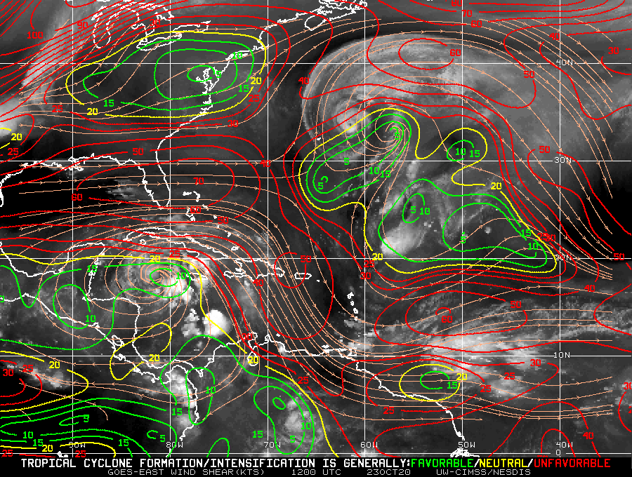
It is clear why the HWRF and HMON bring this north and NE over Cuba and South Florida / FL Straits looking at the steering flow here:

2 likes
ATL: INVEST 95L - Discussion
Hmm, lacks juice and there's a heck of a lot of shear to its north...
We'll see...
We'll see...
0 likes
Who is online
Users browsing this forum: No registered users and 68 guests