ATL: ZETA - Models
Moderator: S2k Moderators

-
cp79
Re: ATL: INVEST 95L - Models
Looking like either a Michael, Sally or Delta track from what I’m seeing. Most of Fla looking in better shape while eyes on the northern gulf coast again. How much more can they take?
0 likes

Re: ATL: INVEST 95L - Models
12z GFS para trending stronger.

0 likes
The following post is NOT an official forecast and should not be used as such. It is just the opinion of the poster and may or may not be backed by sound meteorological data. It is NOT endorsed by any professional institution including storm2k.org For Official Information please refer to the NHC and NWS products.
-
TheStormExpert
Re: ATL: INVEST 95L - Models
cp79 wrote:Looking like either a Michael, Sally or Delta track from what I’m seeing. Most of Fla looking in better shape while eyes on the northern gulf coast again. How much more can they take?
Not exactly. If I were in Florida I wouldn’t take my eyes off this as a track towards Florida or even south of Florida is favored this time of year. The Western Gulf from Texas to Louisiana/Mississippi is closed for business now due to cold front passages.
1 likes

Re: ATL: INVEST 95L - Models
SFLcane wrote:12z Hwrf comes east.
Yeah but will it bend back to the NW or W-NW as the high builds in?
1 likes
Re: ATL: INVEST 95L - Models
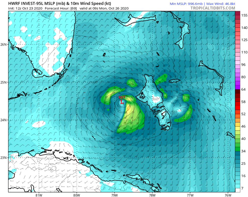
12z HMON takes a trip up I-75 to Tampa from Naples.
https://www.tropicaltidbits.com/analysis/models/?model=hmon®ion=95L&pkg=mslp_pcpn_frzn&runtime=2020102312&fh=6
https://www.tropicaltidbits.com/analysis/models/?model=hmon®ion=95L&pkg=mslp_pcpn_frzn&runtime=2020102312&fh=6
2 likes
-
AutoPenalti
- Category 5

- Posts: 4091
- Age: 29
- Joined: Mon Aug 17, 2015 4:16 pm
- Location: Ft. Lauderdale, Florida
Re: ATL: INVEST 95L - Models
HMON gives Metro-Dade and Broward the nasty side of 95L.
0 likes
The posts in this forum are NOT official forecasts and should not be used as such. They are just the opinion of the poster and may or may not be backed by sound meteorological data. They are NOT endorsed by any professional institution or STORM2K. For official information, please refer to products from the NHC and NWS.
Model Runs Cheat Sheet:
GFS (5:30 AM/PM, 11:30 AM/PM)
HWRF, GFDL, UKMET, NAVGEM (6:30-8:00 AM/PM, 12:30-2:00 AM/PM)
ECMWF (1:45 AM/PM)
TCVN is a weighted averaged
-
SouthFLTropics

- Category 5
- Posts: 4258
- Age: 50
- Joined: Thu Aug 14, 2003 8:04 am
- Location: Port St. Lucie, Florida
Re: ATL: INVEST 95L - Models
I'm not real crazy about that HWRF track. I don't like any vortex spinning around over the open waters of the Bahamas and headed my direction.
0 likes
Fourth Generation Florida Native
Personal Storm History: David 79, Andrew 92, Erin 95, Floyd 99, Irene 99, Frances 04, Jeanne 04, Wilma 05, Matthew 16, Irma 17, Ian 22, Nicole 22, Milton 24
Personal Storm History: David 79, Andrew 92, Erin 95, Floyd 99, Irene 99, Frances 04, Jeanne 04, Wilma 05, Matthew 16, Irma 17, Ian 22, Nicole 22, Milton 24
-
gatorcane

- S2K Supporter

- Posts: 23708
- Age: 48
- Joined: Sun Mar 13, 2005 3:54 pm
- Location: Boca Raton, FL
Re: ATL: INVEST 95L - Models
Euro shifts east and brings the area near the SW coast of Florida before turning it west into the open Gulf. Weak for now but it has done poorly with genesis this year.
0 likes
-
Iceresistance

- Category 5
- Posts: 9574
- Age: 22
- Joined: Sat Oct 10, 2020 9:45 am
- Location: Tecumseh, OK/Norman, OK
Re: ATL: INVEST 95L - Models
NHC now saying 70-70% chance for 95L. This might be Zeta, tying the named systems in 2005. I would be absolutly crazy if we reach 30 named systems.
0 likes
Bill 2015 & Beta 2020
Winter 2020-2021
All observations are in Tecumseh, OK unless otherwise noted.
Winter posts are focused mainly for Oklahoma & Texas.
Take any of my forecasts with a grain of salt, refer to the NWS, SPC, and NHC for official information
Never say Never with weather! Because ANYTHING is possible!
Winter 2020-2021
All observations are in Tecumseh, OK unless otherwise noted.
Winter posts are focused mainly for Oklahoma & Texas.
Take any of my forecasts with a grain of salt, refer to the NWS, SPC, and NHC for official information
Never say Never with weather! Because ANYTHING is possible!
-
ElectricStorm

- Category 5
- Posts: 5127
- Age: 25
- Joined: Tue Aug 13, 2019 11:23 pm
- Location: Norman, OK
Re: ATL: INVEST 95L - Models
Iceresistance wrote:NHC now saying 70-70% chance for 95L. This might be Zeta, tying the named systems in 2005. I would be absolutly crazy if we reach 30 named systems.
Actually 2005 had 1 more, an unnamed system classified in post analysis. So we would have to get to Eta to tie, which I think we will easily
0 likes
B.S Meteorology, University of Oklahoma '25
Please refer to the NHC, NWS, or SPC for official information.
Please refer to the NHC, NWS, or SPC for official information.
Re: ATL: INVEST 95L - Models
I wouldn't put too much on any model considering they are still performing like a windshield wiper, though any rapid development favors a northeastward track...
Last edited by Frank2 on Fri Oct 23, 2020 2:22 pm, edited 1 time in total.
0 likes
-
Spacecoast

- Category 2

- Posts: 773
- Joined: Thu Aug 31, 2017 2:03 pm

Re: ATL: INVEST 95L - Models
TheStormExpert wrote:cp79 wrote:Looking like either a Michael, Sally or Delta track from what I’m seeing. Most of Fla looking in better shape while eyes on the northern gulf coast again. How much more can they take?
Not exactly. If I were in Florida I wouldn’t take my eyes off this as a track towards Florida or even south of Florida is favored this time of year. The Western Gulf from Texas to Louisiana/Mississippi is closed for business now due to cold front passages.
I agree with you....if I were in Florida...I would be monitoring this system frequently....I believe we here in Texas, and a bit eastward should fare ok....isn't there a significant front on the way by next Thursday?....which should keep any given system away...and force it eastward, or eventually Northeasters?....are the models showing this?
Last edited by underthwx on Fri Oct 23, 2020 2:48 pm, edited 1 time in total.
0 likes
-
Loveweather12
- Tropical Storm

- Posts: 136
- Joined: Thu Aug 20, 2020 2:37 pm
Re: ATL: INVEST 95L - Models
cp79 wrote:Looking like either a Michael, Sally or Delta track from what I’m seeing. Most of Fla looking in better shape while eyes on the northern gulf coast again. How much more can they take?
Considering the recent takes from many on here that no storm is forming & the season is done. I wouldn’t make statements like this for this storm. Mother Nature does what she wants too.
All of FL needs to watch this.
1 likes
-
Iceresistance
- Category 5
- Posts: 9574
- Age: 22
- Joined: Sat Oct 10, 2020 9:45 am
- Location: Tecumseh, OK/Norman, OK
Re: ATL: INVEST 95L - Models
Weather Dude wrote:Iceresistance wrote:NHC now saying 70-70% chance for 95L. This might be Zeta, tying the named systems in 2005. I would be absolutly crazy if we reach 30 named systems.
Actually 2005 had 1 more, an unnamed system classified in post analysis. So we would have to get to Eta to tie, which I think we will easily
I did say named systems, there was a forgotten SS over the Azores.
0 likes
Bill 2015 & Beta 2020
Winter 2020-2021
All observations are in Tecumseh, OK unless otherwise noted.
Winter posts are focused mainly for Oklahoma & Texas.
Take any of my forecasts with a grain of salt, refer to the NWS, SPC, and NHC for official information
Never say Never with weather! Because ANYTHING is possible!
Winter 2020-2021
All observations are in Tecumseh, OK unless otherwise noted.
Winter posts are focused mainly for Oklahoma & Texas.
Take any of my forecasts with a grain of salt, refer to the NWS, SPC, and NHC for official information
Never say Never with weather! Because ANYTHING is possible!
-
Iceresistance
- Category 5
- Posts: 9574
- Age: 22
- Joined: Sat Oct 10, 2020 9:45 am
- Location: Tecumseh, OK/Norman, OK
Re: ATL: INVEST 95L - Models
Loveweather12 wrote:cp79 wrote:Looking like either a Michael, Sally or Delta track from what I’m seeing. Most of Fla looking in better shape while eyes on the northern gulf coast again. How much more can they take?
Considering the recent takes from many on here that no storm is forming & the season is done. I wouldn’t make statements like this for this storm. Mother Nature does what she wants too.
All of FL needs to watch this.
And the East Coast if the system is forced east but still wants to go north
0 likes
Bill 2015 & Beta 2020
Winter 2020-2021
All observations are in Tecumseh, OK unless otherwise noted.
Winter posts are focused mainly for Oklahoma & Texas.
Take any of my forecasts with a grain of salt, refer to the NWS, SPC, and NHC for official information
Never say Never with weather! Because ANYTHING is possible!
Winter 2020-2021
All observations are in Tecumseh, OK unless otherwise noted.
Winter posts are focused mainly for Oklahoma & Texas.
Take any of my forecasts with a grain of salt, refer to the NWS, SPC, and NHC for official information
Never say Never with weather! Because ANYTHING is possible!
Who is online
Users browsing this forum: No registered users and 13 guests