https://twitter.com/TylerJStanfield/status/1319733579686023169
ATL: ZETA - Post-Tropical - Discussion
Moderator: S2k Moderators
-
cycloneye

- Admin

- Posts: 149508
- Age: 69
- Joined: Thu Oct 10, 2002 10:54 am
- Location: San Juan, Puerto Rico
Re: ATL: INVEST 95L - Discussion
0 likes
Visit the Caribbean-Central America Weather Thread where you can find at first post web cams,radars
and observations from Caribbean basin members Click Here
and observations from Caribbean basin members Click Here
Re: ATL: INVEST 95L - Discussion
SouthFLTropics wrote:Just by looking at satellite, if that blob from the SE rotates to the North and then NW, I think we may get a center reformation somewhere between Grand Cayman and Little Cayman. If that happens and the convection consolidates around it, I think it would be off to the races and a more NE track will be in the cards.
I for one agree with you....I have been watching satellite loops, I see what you are referring to...is a recon mission scheduled?
0 likes
-
gatorcane

- S2K Supporter

- Posts: 23708
- Age: 48
- Joined: Sun Mar 13, 2005 3:54 pm
- Location: Boca Raton, FL
Re: ATL: INVEST 95L - Discussion
Continues to grow in size as convection builds and expands. Does have the “look” something is trying to develop.
1 likes
-
SouthFLTropics

- Category 5

- Posts: 4258
- Age: 50
- Joined: Thu Aug 14, 2003 8:04 am
- Location: Port St. Lucie, Florida
Re: ATL: INVEST 95L - Discussion
On visible, look at the area south of Little Cayman and in line and directly between Grand Cayman and Jamaica. Looks like some good rotation there. Not sure if this is the MLC or a relocated LLC.
2 likes
Fourth Generation Florida Native
Personal Storm History: David 79, Andrew 92, Erin 95, Floyd 99, Irene 99, Frances 04, Jeanne 04, Wilma 05, Matthew 16, Irma 17, Ian 22, Nicole 22, Milton 24
Personal Storm History: David 79, Andrew 92, Erin 95, Floyd 99, Irene 99, Frances 04, Jeanne 04, Wilma 05, Matthew 16, Irma 17, Ian 22, Nicole 22, Milton 24
-
Aric Dunn
- Category 5
- Posts: 21238
- Age: 43
- Joined: Sun Sep 19, 2004 9:58 pm
- Location: Ready for the Chase.
- Contact:
Re: ATL: INVEST 95L - Discussion
Center is right south of Grand cayman. right about where the number 25 is.

2 likes
Note: If I make a post that is brief. Please refer back to previous posts for the analysis or reasoning. I do not re-write/qoute what my initial post said each time.
If there is nothing before... then just ask
Space & Atmospheric Physicist, Embry-Riddle Aeronautical University,
I believe the sky is falling...
If there is nothing before... then just ask
Space & Atmospheric Physicist, Embry-Riddle Aeronautical University,
I believe the sky is falling...
-
SFLcane

- S2K Supporter
- Posts: 10281
- Age: 48
- Joined: Sat Jun 05, 2010 1:44 pm
- Location: Lake Worth Florida
Re: ATL: INVEST 95L - Discussion
gatorcane wrote:Continues to grow in size as convection builds and expands. Does have the “look” something is trying to develop.
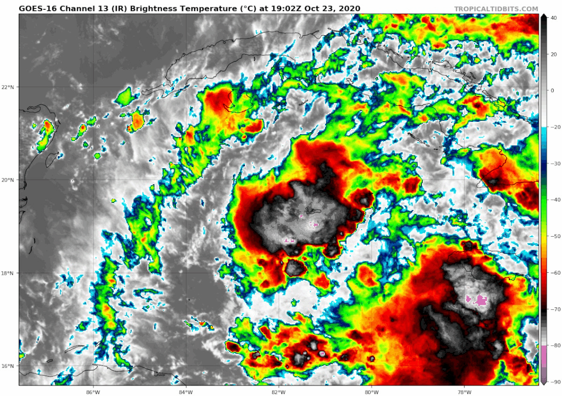
https://i.postimg.cc/jSGRVc84/goes16-ir-95-L-202010231902.gif
I am quite impressed actually very impressive satellite appearance.
0 likes
-
SouthFLTropics
- Category 5
- Posts: 4258
- Age: 50
- Joined: Thu Aug 14, 2003 8:04 am
- Location: Port St. Lucie, Florida
Re: ATL: INVEST 95L - Discussion
Must be the MLC that I'm seeing further off to the ESE. Looks like it's steady heading WNW towards the LLC. They may get stacked here shortly.
0 likes
Fourth Generation Florida Native
Personal Storm History: David 79, Andrew 92, Erin 95, Floyd 99, Irene 99, Frances 04, Jeanne 04, Wilma 05, Matthew 16, Irma 17, Ian 22, Nicole 22, Milton 24
Personal Storm History: David 79, Andrew 92, Erin 95, Floyd 99, Irene 99, Frances 04, Jeanne 04, Wilma 05, Matthew 16, Irma 17, Ian 22, Nicole 22, Milton 24
Re: ATL: INVEST 95L - Discussion
SouthFLTropics wrote:On visible, look at the area south of Little Cayman and in line and directly between Grand Cayman and Jamaica. Looks like some good rotation there. Not sure if this is the MLC or a relocated LLC.
Yes...just might be....95L is getting healthier and healthier as time marches on.....
0 likes

Re: ATL: INVEST 95L - Discussion
Obviously ramping up in organization quickly.
My bet is that unless this is a TD already, it will probably be designated PTC 28 (yes, 28!) by the 11 PM advisory cycle tonight. Some of the more aggressive model runs (the HMON, for example) are showing tropical storm force wind impacts in Cuba within the 48 hour time frame.
My bet is that unless this is a TD already, it will probably be designated PTC 28 (yes, 28!) by the 11 PM advisory cycle tonight. Some of the more aggressive model runs (the HMON, for example) are showing tropical storm force wind impacts in Cuba within the 48 hour time frame.
Last edited by us89 on Fri Oct 23, 2020 3:36 pm, edited 1 time in total.
0 likes


-
Blown Away

- S2K Supporter
- Posts: 10253
- Joined: Wed May 26, 2004 6:17 am
Re: ATL: INVEST 95L - Discussion
SouthFLTropics wrote:Just by looking at satellite, if that blob from the SE rotates to the North and then NW, I think we may get a center reformation somewhere between Grand Cayman and Little Cayman. If that happens and the convection consolidates around it, I think it would be off to the races and a more NE track will be in the cards.
I agree, I think the deeper/stronger 95L goes NE and shallow/weaker 95L goes NW like most of the global models show ATM.
1 likes
Hurricane Eye Experience: David 79, Irene 99, Frances 04, Jeanne 04, Wilma 05… Hurricane Brush Experience: Andrew 92, Erin 95, Floyd 99, Matthew 16, Irma 17, Ian 22, Nicole 22…
-
TheStormExpert
Re: ATL: INVEST 95L - Discussion
underthwx wrote:SouthFLTropics wrote:Just by looking at satellite, if that blob from the SE rotates to the North and then NW, I think we may get a center reformation somewhere between Grand Cayman and Little Cayman. If that happens and the convection consolidates around it, I think it would be off to the races and a more NE track will be in the cards.
I for one agree with you....I have been watching satellite loops, I see what you are referring to...is a recon mission scheduled?
RECON goes in tomorrow.
2 likes

-
Weatherboy1

- Category 5
- Posts: 1190
- Age: 50
- Joined: Mon Jul 05, 2004 1:50 pm
- Location: Jupiter/Sarasota, FL
Re: ATL: INVEST 95L - Discussion
This time of year, I think you have to give more weight to models with more of an easterly bias/forecast. We’re almost into November, and that means fronts/troughs are stronger and you then to see more NNE/NE than NW tracks
4 likes

-
AnnularCane

- S2K Supporter
- Posts: 2962
- Joined: Thu Jun 08, 2006 9:18 am
- Location: Wytheville, VA
Re: ATL: INVEST 95L - Discussion
It may be difficult for me, at least at first, to see this storm as "Zeta." To me Zeta is that cute little post-Christmas storm that everybody rang in the New Year with. It may take a little while to get used to another storm with that name, especially one that's so different from the last one. 
8 likes
Re: ATL: INVEST 95L - Discussion
Looking at a satellite loop...is 95L drifting basically North, or possibly NNW?...
2 likes
-
gatorcane
- S2K Supporter
- Posts: 23708
- Age: 48
- Joined: Sun Mar 13, 2005 3:54 pm
- Location: Boca Raton, FL
Re: ATL: INVEST 95L - Discussion
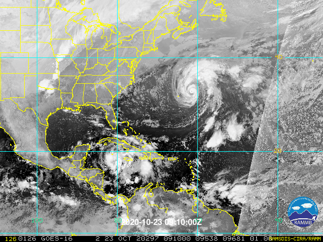
Looking at the big picture, looks like it is on its way to developing, lots of spin:
1 likes
-
AutoPenalti
- Category 5
- Posts: 4091
- Age: 29
- Joined: Mon Aug 17, 2015 4:16 pm
- Location: Ft. Lauderdale, Florida
Re: ATL: INVEST 95L - Discussion
Looks squashed aloft.
0 likes
The posts in this forum are NOT official forecasts and should not be used as such. They are just the opinion of the poster and may or may not be backed by sound meteorological data. They are NOT endorsed by any professional institution or STORM2K. For official information, please refer to products from the NHC and NWS.
Model Runs Cheat Sheet:
GFS (5:30 AM/PM, 11:30 AM/PM)
HWRF, GFDL, UKMET, NAVGEM (6:30-8:00 AM/PM, 12:30-2:00 AM/PM)
ECMWF (1:45 AM/PM)
TCVN is a weighted averaged
Re: ATL: INVEST 95L - Discussion
gatorcane wrote:Looking at the big picture, looks like it is on its way to developing, lots of spin:
https://i.postimg.cc/6Q6j62Mb/48-E6-DF6-D-5-CDA-430-E-84-DF-1-C7-CBE931-F96.gif
Absolutely gatorcane....may I ask where I can find that satellite loop?...thanks...
0 likes
Who is online
Users browsing this forum: No registered users and 37 guests