ATL: ZETA - Models
Moderator: S2k Moderators
-
Blown Away

- S2K Supporter

- Posts: 10253
- Joined: Wed May 26, 2004 6:17 am
Re: ATL: ZETA - Models
06z Euro & GFS @400 miles apart in the 3-4 day range, that’s huge. Something is going to give with the models soon, I’m thinking Zeta is going to spend more time than forecasted meandering in the NW Caribbean and/or over Yucatan Peninsula. Climatology is so overwhelming against a landfall W of @Pensacola in late October.
5 likes
Hurricane Eye Experience: David 79, Irene 99, Frances 04, Jeanne 04, Wilma 05… Hurricane Brush Experience: Andrew 92, Erin 95, Floyd 99, Matthew 16, Irma 17, Ian 22, Nicole 22…
-
Blown Away
- S2K Supporter
- Posts: 10253
- Joined: Wed May 26, 2004 6:17 am
Re: ATL: ZETA - Models
Looking at the 06z GFS ensembles. The operational landfalls @MS/Bama and nearly all ensembles to the W are very weak and the ensembles to the E are mostly strong hurricanes.
0 likes
Hurricane Eye Experience: David 79, Irene 99, Frances 04, Jeanne 04, Wilma 05… Hurricane Brush Experience: Andrew 92, Erin 95, Floyd 99, Matthew 16, Irma 17, Ian 22, Nicole 22…
-
cp79
Re: ATL: ZETA - Models
Still looking good for the Fla peninsula but panhandle could be increasingly in trouble.
1 likes

Re: ATL: ZETA - Models
06 Euro ensembles much weaker, might be a reason for its more western track.
I think is safe to say that a stronger Zeta could mean a more eastward track, though the strength of the ridge moving over FL the couple of days will also have a big play as the cut off ULL that will eject out of the SW US.


I think is safe to say that a stronger Zeta could mean a more eastward track, though the strength of the ridge moving over FL the couple of days will also have a big play as the cut off ULL that will eject out of the SW US.
4 likes
Re: ATL: ZETA - Models
A reason to dismiss the 06z GFS Para track, it shows it hitting the western tip of Cuba, that's not happening.

0 likes


Re: ATL: ZETA - Models
NDG wrote:A reason to dismiss the 06z GFS Para track, it shows it hitting the western tip of Cuba, that's not happening.
https://i.imgur.com/jZqe306.png
It also initialized Zeta WAY too far north. Just like with Delta, it has a N bias for WCar systems.
3 likes
Irene '11 Sandy '12 Hermine '16 5/15/2018 Derecho Fay '20 Isaias '20 Elsa '21 Henri '21 Ida '21
I am only a meteorology enthusiast who knows a decent amount about tropical cyclones. Look to the professional mets, the NHC, or your local weather office for the best information.
I am only a meteorology enthusiast who knows a decent amount about tropical cyclones. Look to the professional mets, the NHC, or your local weather office for the best information.
-
Blown Away
- S2K Supporter
- Posts: 10253
- Joined: Wed May 26, 2004 6:17 am
Re: ATL: ZETA - Models
NDG wrote:A reason to dismiss the 06z GFS Para track, it shows it hitting the western tip of Cuba, that's not happening.
https://i.imgur.com/jZqe306.png
Agree, but 11pm predicted Zeta at 19.2N at 12z and Zeta at @17.8N... That’s @70 miles and of Zeta strengthens faster than expected, which is possible, the E shifts are going to happen.
0 likes
Hurricane Eye Experience: David 79, Irene 99, Frances 04, Jeanne 04, Wilma 05… Hurricane Brush Experience: Andrew 92, Erin 95, Floyd 99, Matthew 16, Irma 17, Ian 22, Nicole 22…
-
cp79
Re: ATL: ZETA - Models
Blown Away wrote:NDG wrote:A reason to dismiss the 06z GFS Para track, it shows it hitting the western tip of Cuba, that's not happening.
https://i.imgur.com/jZqe306.png
Agree, but 11pm predicted Zeta at 19.2N at 12z and Zeta at @17.8N... That’s @70 miles and of Zeta strengthens faster than expected, which is possible, the E shifts are going to happen.
East shifts at landfall, I agree. I think Pensacola and Mobile now more under the gun. But for the next 72-96 hours, I think this stays still and then eventually moves NW into S. Central Gulf as HP will guide it there before the front moves in. If there was no HP coming in, I’d agree this thing would move more East short term. But there won’t be any easterly move until the front and by then it should be well into the Gulf. I still wouldn’t rule out New Orleans and La. as it could swing wide left like Delta bc of HP.
0 likes

Re: ATL: ZETA - Models
As the uncertainty grows. Here are some hypothetical scenarios using our less sophisticated dynamic models. The deeper system will follow the blue line. Climo is represented by the red lines for those that follow that. I think the blue is certainly possible the longer it sits down there.

Close-up

Close-up
3 likes
The following post is NOT an official forecast and should not be used as such. It is just the opinion of the poster and may or may not be backed by sound meteorological data. It is NOT endorsed by any professional institution including storm2k.org For Official Information please refer to the NHC and NWS products.
Re: ATL: ZETA - Models
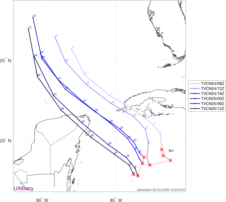
Shifts last few days:
0 likes
The following post is NOT an official forecast and should not be used as such. It is just the opinion of the poster and may or may not be backed by sound meteorological data. It is NOT endorsed by any professional institution including storm2k.org For Official Information please refer to the NHC and NWS products.

-
Frank P
- S2K Supporter
- Posts: 2779
- Joined: Fri Aug 29, 2003 10:52 am
- Location: Biloxi Beach, Ms
- Contact:
Re: ATL: ZETA - Models
bella_may wrote:12Z GFS shifted west to MS coast
12z ICON shifted west to SELA Cat 1 985 mb
0 likes
-
GeneratorPower

- S2K Supporter
- Posts: 1648
- Age: 46
- Joined: Sun Dec 18, 2005 11:48 pm
- Location: Huntsville, AL
Re: ATL: ZETA - Models
cp79 wrote:These west shifts continue. Texas could be back in play.
Come on man. Same deal as last time. Creole, LA.
4 likes
Re: ATL: ZETA - Models
If these south shifts are confirmed by recon then models are going to be off. They are all too far North and had this slowly moving NNW today instead of SSW. Too early to put any stock in the models until this finally consolidates.
Last edited by blp on Sun Oct 25, 2020 12:25 pm, edited 1 time in total.
3 likes
The following post is NOT an official forecast and should not be used as such. It is just the opinion of the poster and may or may not be backed by sound meteorological data. It is NOT endorsed by any professional institution including storm2k.org For Official Information please refer to the NHC and NWS products.
-
cp79
Re: ATL: ZETA - Models
Euro shifting WAY west. Landfall appears to be Texas or right on the border. Wow. Huge west shifts today.
0 likes
-
Blown Away
- S2K Supporter
- Posts: 10253
- Joined: Wed May 26, 2004 6:17 am
Re: ATL: ZETA - Models
cp79 wrote:Euro shifting WAY west. Landfall appears to be Texas or right on the border. Wow. Huge west shifts today.
Very weak, maybe TD/Low end TS strength as Euro goes W...
0 likes
Hurricane Eye Experience: David 79, Irene 99, Frances 04, Jeanne 04, Wilma 05… Hurricane Brush Experience: Andrew 92, Erin 95, Floyd 99, Matthew 16, Irma 17, Ian 22, Nicole 22…
-
Stormcenter
- S2K Supporter
- Posts: 6689
- Joined: Wed Sep 03, 2003 11:27 am
- Location: Houston, TX
Re: ATL: ZETA - Models
Maybe the trough is not going to sweep through as
quickly as originally thought.
quickly as originally thought.
0 likes
-
cp79
Re: ATL: ZETA - Models
Stormcenter wrote:Maybe the trough is not going to sweep through as
quickly as originally thought.
I think it’s the timing. Euro moves this pretty quick once HP takes over. I think that’s why you’re seeing the shifts today. Has more to do with the strength of the ridge blocking it from moving right and pushing it left.
Only thing I’d caution is the Mitch scenario where the core of Zeta gets trapped and drifts south Into Honduras which it looks to be close to doing now. I don’t think that’ll happen but the strongest storms right now have been pushed south today and it’s barely above land. Center could relocate south. It is a bit of a curveball what’s going on right now bc it seems stuck.
0 likes
Who is online
Users browsing this forum: No registered users and 19 guests