
WPAC: MOLAVE - Post-Tropical
Moderator: S2k Moderators
-
mrbagyo

- Category 5

- Posts: 3963
- Age: 33
- Joined: Thu Apr 12, 2012 9:18 am
- Location: 14.13N 120.98E
- Contact:
Re: WPAC: MOLAVE - Typhoon
radar data is gone again. 
0 likes
The posts in this forum are NOT official forecast and should not be used as such. They are just the opinion of the poster and may or may not be backed by sound meteorological data. They are NOT endorsed by any professional institution or storm2k.org. For official information, please refer to RSMC, NHC and NWS products.
Re: WPAC: MOLAVE - Typhoon
AMSU at 1055Z gives an estimate of 976mb/78kt, which is very consistent with surface observations. An argument for 85kt can also be made if you give more weight to KZC.
0 likes
Personal Forecast Disclaimer:
The posts in this forum are NOT official forecast and should not be used as such. They are just the opinion of the poster and may or may not be backed by sound meteorological data. They are NOT endorsed by any professional institution or storm2k.org. For official information, please refer to RSMC and NWS products.
The posts in this forum are NOT official forecast and should not be used as such. They are just the opinion of the poster and may or may not be backed by sound meteorological data. They are NOT endorsed by any professional institution or storm2k.org. For official information, please refer to RSMC and NWS products.
-
Iceresistance

- Category 5
- Posts: 9574
- Age: 22
- Joined: Sat Oct 10, 2020 9:45 am
- Location: Tecumseh, OK/Norman, OK
Re: WPAC: MOLAVE - Typhoon
JTWC said that Molave will get stronger west of the Philippines, expected to be very strong when it hits Vietnam
0 likes
Bill 2015 & Beta 2020
Winter 2020-2021
All observations are in Tecumseh, OK unless otherwise noted.
Winter posts are focused mainly for Oklahoma & Texas.
Take any of my forecasts with a grain of salt, refer to the NWS, SPC, and NHC for official information
Never say Never with weather! Because ANYTHING is possible!
Winter 2020-2021
All observations are in Tecumseh, OK unless otherwise noted.
Winter posts are focused mainly for Oklahoma & Texas.
Take any of my forecasts with a grain of salt, refer to the NWS, SPC, and NHC for official information
Never say Never with weather! Because ANYTHING is possible!
-
Iceresistance
- Category 5
- Posts: 9574
- Age: 22
- Joined: Sat Oct 10, 2020 9:45 am
- Location: Tecumseh, OK/Norman, OK
Re: WPAC: MOLAVE - Typhoon
Note the eye structure of Molave while it moves over the Philippines when the radar worked.
0 likes
Bill 2015 & Beta 2020
Winter 2020-2021
All observations are in Tecumseh, OK unless otherwise noted.
Winter posts are focused mainly for Oklahoma & Texas.
Take any of my forecasts with a grain of salt, refer to the NWS, SPC, and NHC for official information
Never say Never with weather! Because ANYTHING is possible!
Winter 2020-2021
All observations are in Tecumseh, OK unless otherwise noted.
Winter posts are focused mainly for Oklahoma & Texas.
Take any of my forecasts with a grain of salt, refer to the NWS, SPC, and NHC for official information
Never say Never with weather! Because ANYTHING is possible!
-
mrbagyo
- Category 5
- Posts: 3963
- Age: 33
- Joined: Thu Apr 12, 2012 9:18 am
- Location: 14.13N 120.98E
- Contact:
Re: WPAC: MOLAVE - Typhoon
Iceresistance wrote:
Note the eye structure of Molave while it moves over the Philippines when the radar worked.
The radars are working fine, they (PAGASA) just doesn't release all the radar data.
0 likes
The posts in this forum are NOT official forecast and should not be used as such. They are just the opinion of the poster and may or may not be backed by sound meteorological data. They are NOT endorsed by any professional institution or storm2k.org. For official information, please refer to RSMC, NHC and NWS products.
-
Iceresistance
- Category 5
- Posts: 9574
- Age: 22
- Joined: Sat Oct 10, 2020 9:45 am
- Location: Tecumseh, OK/Norman, OK
Re: WPAC: MOLAVE - Typhoon
mrbagyo wrote:Iceresistance wrote:
Note the eye structure of Molave while it moves over the Philippines when the radar worked.
The radars are working fine, they (PAGASA) just doesn't release all the radar data.
I see then, but look at the eye structure, a very great call by the JTWC to upgrade this to a Typhoon.
0 likes
Bill 2015 & Beta 2020
Winter 2020-2021
All observations are in Tecumseh, OK unless otherwise noted.
Winter posts are focused mainly for Oklahoma & Texas.
Take any of my forecasts with a grain of salt, refer to the NWS, SPC, and NHC for official information
Never say Never with weather! Because ANYTHING is possible!
Winter 2020-2021
All observations are in Tecumseh, OK unless otherwise noted.
Winter posts are focused mainly for Oklahoma & Texas.
Take any of my forecasts with a grain of salt, refer to the NWS, SPC, and NHC for official information
Never say Never with weather! Because ANYTHING is possible!
-
ElectricStorm

- Category 5
- Posts: 5127
- Age: 25
- Joined: Tue Aug 13, 2019 11:23 pm
- Location: Norman, OK
Re: WPAC: MOLAVE - Typhoon
Iceresistance wrote:mrbagyo wrote:Iceresistance wrote:Note the eye structure of Molave while it moves over the Philippines when the radar worked.
The radars are working fine, they (PAGASA) just doesn't release all the radar data.
I see then, but look at the eye structure, a very great call by the JTWC to upgrade this to a Typhoon.
Yes but the problem is they waited way too long to upgrade. They should have upgraded yesterday.
0 likes
B.S Meteorology, University of Oklahoma '25
Please refer to the NHC, NWS, or SPC for official information.
Please refer to the NHC, NWS, or SPC for official information.
-
Iceresistance
- Category 5
- Posts: 9574
- Age: 22
- Joined: Sat Oct 10, 2020 9:45 am
- Location: Tecumseh, OK/Norman, OK
Re: WPAC: MOLAVE - Typhoon
Weather Dude wrote:Iceresistance wrote:mrbagyo wrote:
The radars are working fine, they (PAGASA) just doesn't release all the radar data.
I see then, but look at the eye structure, a very great call by the JTWC to upgrade this to a Typhoon.
Yes but the problem is they waited way too long to upgrade. They should have upgraded yesterday.
It likely bacame a typhoon rapidly very close to the Philippines, & in between JTWC warnings.
0 likes
Bill 2015 & Beta 2020
Winter 2020-2021
All observations are in Tecumseh, OK unless otherwise noted.
Winter posts are focused mainly for Oklahoma & Texas.
Take any of my forecasts with a grain of salt, refer to the NWS, SPC, and NHC for official information
Never say Never with weather! Because ANYTHING is possible!
Winter 2020-2021
All observations are in Tecumseh, OK unless otherwise noted.
Winter posts are focused mainly for Oklahoma & Texas.
Take any of my forecasts with a grain of salt, refer to the NWS, SPC, and NHC for official information
Never say Never with weather! Because ANYTHING is possible!
-
ElectricStorm
- Category 5
- Posts: 5127
- Age: 25
- Joined: Tue Aug 13, 2019 11:23 pm
- Location: Norman, OK
Re: WPAC: MOLAVE - Typhoon
Iceresistance wrote:Weather Dude wrote:Iceresistance wrote:I see then, but look at the eye structure, a very great call by the JTWC to upgrade this to a Typhoon.
Yes but the problem is they waited way too long to upgrade. They should have upgraded yesterday.
It likely bacame a typhoon rapidly very close to the Philippines, & in between JTWC warnings.
No. It was a typhoon for awhile yesterday with that eye. JTWC refused to upgrade it until it made landfall which makes absolutely no sense... But at least they actually have it as a typhoon now. They struggle with RI's
0 likes
B.S Meteorology, University of Oklahoma '25
Please refer to the NHC, NWS, or SPC for official information.
Please refer to the NHC, NWS, or SPC for official information.
-
Iceresistance
- Category 5
- Posts: 9574
- Age: 22
- Joined: Sat Oct 10, 2020 9:45 am
- Location: Tecumseh, OK/Norman, OK
Re: WPAC: MOLAVE - Typhoon
Weather Dude wrote:Iceresistance wrote:Weather Dude wrote:Yes but the problem is they waited way too long to upgrade. They should have upgraded yesterday.
It likely bacame a typhoon rapidly very close to the Philippines, & in between JTWC warnings.
No. It was a typhoon for awhile yesterday with that eye. JTWC refused to upgrade it until it made landfall which makes absolutely no sense... But at least they actually have it as a typhoon now. They struggle with RI's
They also struggle with the Dvorak technique, Severe Tropical Storms had eyes, but they were unsure if it was a typhoon, the JMA always call tropical systems typhoons if it had an eye & persists.
0 likes
Bill 2015 & Beta 2020
Winter 2020-2021
All observations are in Tecumseh, OK unless otherwise noted.
Winter posts are focused mainly for Oklahoma & Texas.
Take any of my forecasts with a grain of salt, refer to the NWS, SPC, and NHC for official information
Never say Never with weather! Because ANYTHING is possible!
Winter 2020-2021
All observations are in Tecumseh, OK unless otherwise noted.
Winter posts are focused mainly for Oklahoma & Texas.
Take any of my forecasts with a grain of salt, refer to the NWS, SPC, and NHC for official information
Never say Never with weather! Because ANYTHING is possible!
-
1900hurricane

- Category 5
- Posts: 6063
- Age: 34
- Joined: Fri Feb 06, 2015 12:04 pm
- Location: Houston, TX
- Contact:
Re: WPAC: MOLAVE - Typhoon
Up to 75 kt now.
0 likes
Contract Meteorologist. TAMU & MSST. Fiercely authentic, one of a kind. We are all given free will, so choose a life meant to be lived. We are the Masters of our own Stories.
Opinions expressed are mine alone.
Follow me on Twitter at @1900hurricane : Read blogs at https://1900hurricane.wordpress.com/
Opinions expressed are mine alone.
Follow me on Twitter at @1900hurricane : Read blogs at https://1900hurricane.wordpress.com/
-
Ed_2001

- Tropical Storm

- Posts: 246
- Age: 24
- Joined: Wed Jun 21, 2017 11:39 pm
- Location: Santa Barbara, CA>>Tampa, FL
Re: WPAC: MOLAVE - Typhoon
Iceresistance wrote:JTWC said that Molave will get stronger west of the Philippines, expected to be very strong when it hits Vietnam
https://www.metoc.navy.mil/jtwc/products/wp2120.gif
That’s not good...hitting nearly the same area already heavily impacted from floods brought by TS Linfa and at a much stronger intensity as well.
0 likes
The answer my friend, is blowing in the wind...
-
mrbagyo
- Category 5
- Posts: 3963
- Age: 33
- Joined: Thu Apr 12, 2012 9:18 am
- Location: 14.13N 120.98E
- Contact:
Re: WPAC: MOLAVE - Typhoon
Rainfall is really more intense with this typhoon compared to other typhoons that passed south of my location (Tagaytay).
Last time i experienced rainfall of this magnitude from a TC was way back in 2009 - Ketsana. This probably wont last as long though - Molave is moving away.
Last time i experienced rainfall of this magnitude from a TC was way back in 2009 - Ketsana. This probably wont last as long though - Molave is moving away.
0 likes
The posts in this forum are NOT official forecast and should not be used as such. They are just the opinion of the poster and may or may not be backed by sound meteorological data. They are NOT endorsed by any professional institution or storm2k.org. For official information, please refer to RSMC, NHC and NWS products.
-
doomhaMwx

- Category 5
- Posts: 2487
- Age: 27
- Joined: Tue Apr 18, 2017 4:01 am
- Location: Baguio/Benguet, Philippines
- Contact:
Re: WPAC: MOLAVE - Typhoon
Still looking good even while passing over the mountainous Mindoro.


0 likes
-
mrbagyo
- Category 5
- Posts: 3963
- Age: 33
- Joined: Thu Apr 12, 2012 9:18 am
- Location: 14.13N 120.98E
- Contact:
Re: WPAC: MOLAVE - Typhoon

0 likes
The posts in this forum are NOT official forecast and should not be used as such. They are just the opinion of the poster and may or may not be backed by sound meteorological data. They are NOT endorsed by any professional institution or storm2k.org. For official information, please refer to RSMC, NHC and NWS products.
-
mrbagyo
- Category 5
- Posts: 3963
- Age: 33
- Joined: Thu Apr 12, 2012 9:18 am
- Location: 14.13N 120.98E
- Contact:
Re: WPAC: MOLAVE - Typhoon
Imran_doomhaMwx wrote:Still looking good even while passing over the mountainous Mindoro.
https://rammb-data.cira.colostate.edu/tc_realtime/products/storms/2020wp21/4kmsrbdc/2020wp21_4kmsrbdc_202010252200.jpg
https://rammb-data.cira.colostate.edu/tc_realtime/products/storms/2020wp21/4kmirimg/2020wp21_4kmirimg_202010252200.gif
Molave: 'Halcon who? Ain't gonna affect me"
0 likes
The posts in this forum are NOT official forecast and should not be used as such. They are just the opinion of the poster and may or may not be backed by sound meteorological data. They are NOT endorsed by any professional institution or storm2k.org. For official information, please refer to RSMC, NHC and NWS products.
-
mrbagyo
- Category 5
- Posts: 3963
- Age: 33
- Joined: Thu Apr 12, 2012 9:18 am
- Location: 14.13N 120.98E
- Contact:
Re: WPAC: MOLAVE - Typhoon
down to 981 mb at SARAI PhilRice Sta. Cruz, Occ. Mindoro (UPLB) - ISANTACR106 - Elev 8 ft, 13.13 °N, 120.70 °E
https://www.wunderground.com/dashboard/pws/ISANTACR106

https://www.wunderground.com/dashboard/pws/ISANTACR106
0 likes
The posts in this forum are NOT official forecast and should not be used as such. They are just the opinion of the poster and may or may not be backed by sound meteorological data. They are NOT endorsed by any professional institution or storm2k.org. For official information, please refer to RSMC, NHC and NWS products.
-
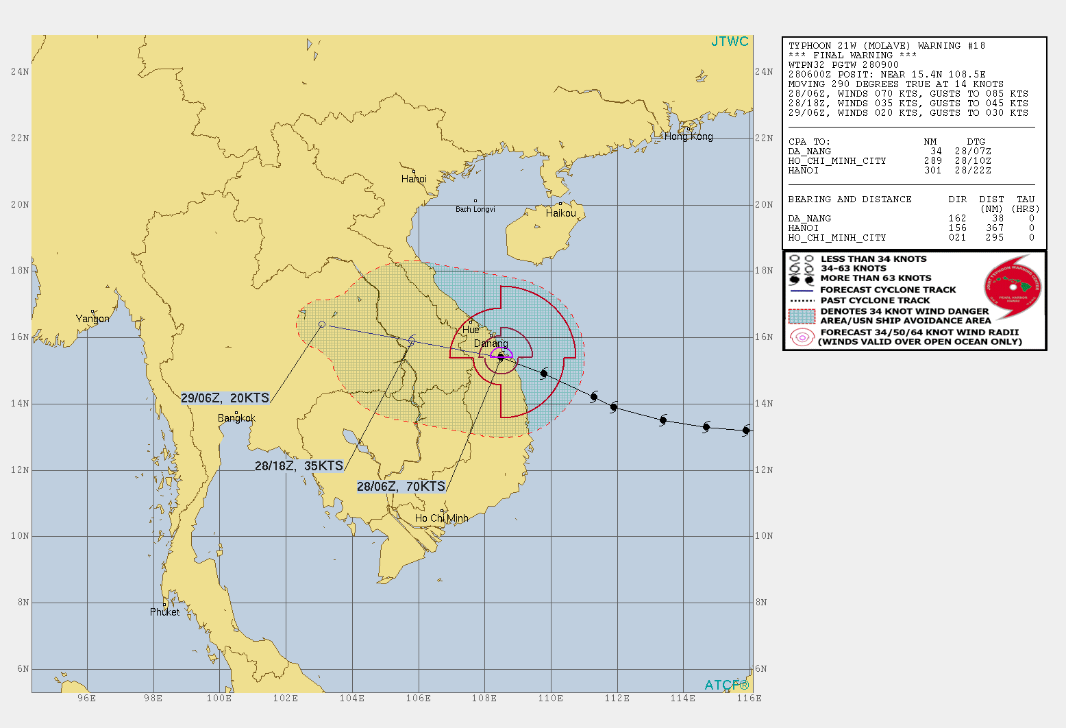
euro6208
Re: WPAC: MOLAVE - Typhoon
Forecast to peak at 95 knots, just shy of Cat 3.
WDPN32 PGTW 252100
MSGID/GENADMIN/JOINT TYPHOON WRNCEN PEARL HARBOR HI//
SUBJ/PROGNOSTIC REASONING FOR TYPHOON 21W (MOLAVE) WARNING NR 008//
RMKS/
1. FOR METEOROLOGISTS.
2. 6 HOUR SUMMARY AND ANALYSIS.
TYPHOON (TY) 21W (MOLAVE), LOCATED APPROXIMATELY 96 NM SOUTH-
SOUTHEAST OF MANILA, PHILIPPINES, HAS TRACKED WESTWARD AT 17 KNOTS
OVER THE PAST SIX HOURS. TY 21W HAS RAPIDLY INTENSIFIED 35 KNOTS
OVER THE PAST 24 HOURS FROM 40 KNOTS AT 24/18Z TO THE CURRENT
INTENSITY OF 75 KNOTS. ANIMATED ENHANCED INFRARED SATELLITE IMAGERY
DEPICTS A CONSOLIDATING SYSTEM WITH AN EXPANDING CENTRAL DENSE
OVERCAST FEATURE. THE IMPROVED CONVECTIVE STRUCTURE IS CLEARLY
EVIDENT IN A 251840Z GMI 89GHZ IMAGE, WHICH SHOWS SPIRAL BANDING AND
A COMPACT EYEWALL SURROUNDING A MICROWAVE EYE FEATURE. THE INITIAL
INTENSITY IS ASSESSED AT 75 KTS BASED ON THE HIGH END OF DVORAK
INTENSITY ESTIMATES RANGING FROM T4.0-4.5 (65-77 KNOTS) AND A
251740Z ADT ESTIMATE OF 4.6 (79 KNOTS). ENVIRONMENTAL ANALYSIS
REVEALS OVERALL FAVORABLE CONDITIONS CHARACTERIZED BY ROBUST
EQUATORWARD OUTFLOW, LOW TO MODERATE (15-20 KTS) VERTICAL WIND
SHEAR, AND WARM (28-29 CELSIUS) SEA SURFACE TEMPERATURES. TY 21W IS
TRACKING WESTWARD ALONG THE SOUTHERN PERIPHERY OF A SUBTROPICAL
RIDGE (STR) POSITIONED TO THE NORTH.
3. FORECAST REASONING.
A. THERE IS NO CHANGE TO THE FORECAST PHILOSOPHY SINCE THE
PREVIOUS PROGNOSTIC REASONING MESSAGE.
B. TY 21W IS FORECAST TO TRACK WESTWARD TO WEST-NORTHWESTWARD
THROUGH TAU 48 UNDER THE STEERING INFLUENCE OF THE DEEP-LAYERED
SUBTROPICAL RIDGE ENTRENCHED TO THE NORTH. AFTER A BRIEF PERIOD OF
WEAKENING AS THE SYSTEM TRACKS OVER PANAY ISLAND, TY 21W SHOULD RE-
INTENSIFY TO A PEAK INTENSITY OF 95 KNOTS BY TAU 24. THE 25/12Z
COAMPS-TC ENSEMBLE INDICATES HIGH POTENTIAL FOR A PEAK OF 90-100
KNOTS WITH A LOW PROBABILITY OF 105 KNOTS. AFTER TAU 48, TY 21W WILL
GRADUALLY WEAKEN AS IT APPROACHES EASTERN VIETNAM WITH LANDFALL
EXPECTED NEAR TAU 60. MORE SIGNIFICANT WEAKENING WILL OCCUR AFTER
TAU 60 AS THE SYSTEM TRACKS INLAND. NUMERICAL MODEL GUIDANCE REMAINS
IN TIGHT AGREEMENT WITH A 90NM SPREAD IN SOLUTIONS AT TAU 60.
C. IN THE EXTENDED RANGE, TY 21W WILL WEAKEN RAPIDLY AS IT TRACKS
WESTWARD OVER MOUNTAINOUS TERRAIN WITH DISSIPATION OVER LAND
EXPECTED BY TAU 96. WITH THE EXCEPTION OF JGSM (A SOUTHERLY
OUTLIER), NUMERICAL MODEL GUIDANCE REMAINS IN TIGHT AGREEMENT
THROUGH TAU 96, LENDING OVERALL HIGH CONFIDENCE IN THE JTWC FORECAST
TRACK WHICH IS PLACED NEAR THE MULTI-MODEL CONSENSUS.//
NNNN
0 likes
-
1900hurricane
- Category 5
- Posts: 6063
- Age: 34
- Joined: Fri Feb 06, 2015 12:04 pm
- Location: Houston, TX
- Contact:
Re: WPAC: MOLAVE - Typhoon
These passes are roughly two hours apart. Unsurprisingly, crossing a mountainous island had a rather adverse effect on the core.


1 likes
Contract Meteorologist. TAMU & MSST. Fiercely authentic, one of a kind. We are all given free will, so choose a life meant to be lived. We are the Masters of our own Stories.
Opinions expressed are mine alone.
Follow me on Twitter at @1900hurricane : Read blogs at https://1900hurricane.wordpress.com/
Opinions expressed are mine alone.
Follow me on Twitter at @1900hurricane : Read blogs at https://1900hurricane.wordpress.com/
-
mrbagyo
- Category 5
- Posts: 3963
- Age: 33
- Joined: Thu Apr 12, 2012 9:18 am
- Location: 14.13N 120.98E
- Contact:
Re: WPAC: MOLAVE - Typhoon
1900hurricane wrote:These passes are roughly two hours apart. Unsurprisingly, crossing a mountainous island had a rather adverse effect on the core.
https://i.imgur.com/92Q2wsR.jpg
https://i.imgur.com/Sq30DwX.jpg
Massive 2,500 masl Mt. Halcon finally doing its thing
0 likes
The posts in this forum are NOT official forecast and should not be used as such. They are just the opinion of the poster and may or may not be backed by sound meteorological data. They are NOT endorsed by any professional institution or storm2k.org. For official information, please refer to RSMC, NHC and NWS products.
Who is online
Users browsing this forum: No registered users and 24 guests