This one would be wave-based which would, in my mind, give it a better head start...
You can imagine what Zeta would have done with such a better head start and less of a cold front...
This is a prolonged game of Russian Roulette for Florida in my opinion...
Area of disturbed weather entering the Caribbean (Is Invest 96L)
Moderator: S2k Moderators
Forum rules

The posts in this forum are NOT official forecasts and should not be used as such. They are just the opinion of the poster and may or may not be backed by sound meteorological data. They are NOT endorsed by any professional institution or STORM2K. For official information, please refer to products from the National Hurricane Center and National Weather Service.
-
cp79
Re: Area of disturbed weather entering the Caribbean
Just my two cents...I know there’s a lot of -removed-, but I do think the fronts coming through Florida and then HP settling in going to keep Fla. safe. Long-term after a week it’s too early to tell if maybe something will pick this up after it goes through CA. I think if it is picked up, it gets kicked out to sea or it’s kicked NW with HP blocking it from Fla, but once again, just my opinion. I could be wrong. Just my two cents.
0 likes
-
northjaxpro

- S2K Supporter

- Posts: 8900
- Joined: Mon Sep 27, 2010 11:21 am
- Location: Jacksonville, FL
Re: Area of disturbed weather entering the Caribbean
Shell Mound wrote:SFLcane wrote:https://i.imgur.com/JrP3YZS.gif
Interestingly, the minority of members that do not show significant interaction with Central America indicate steady intensification as the potential system tracks north-northeastward toward westernmost Cuba, the Keys, and possibly South Florida. Perhaps early November will behave more like early to mid October in regard to the track of this system, just as the peak of this season has clearly been delayed or “backloaded.” If this system somehow stalls offshore and does not do a “Mitch 2.0,” then I am concerned that this could be yet another powerful hurricane over the western Caribbean, à la the 1924/‘32 Cuba hurricanes, Michelle ‘01, and/or Paloma ‘08, at least in terms of potential intensity. Probably the most disconcerting possible outcome would be a drifting, stalling, or even looping motion over the western Caribbean, in the vicinity of the Gulf of Honduras, remaining just offshore/north of Central America, while undergoing significant intensification and eventually tracking NNE toward Pinar del Río, Cuba, and the southeastern Gulf of Mexico, on a track that would clearly and unambiguously threaten the southernmost Florida peninsula and the Keys. Maybe a combination of ‘24’s track and ‘32’s intensity, with a bit of 1846 Havana/Key West thrown in for good measure. Maybe 2020 will save the worst for last and throw a robust Cat-5, Michael-style but offset to the southeast, into the I-4 corridor, from Tampa Bay to Greater Orlando and Cape Canaveral.
This is a very good post and a reminder of how uncertain tracks in the Caribbean this time of the year can be.
There is one thing for certain in my view and it is definitely safe to assume that ANYTHING goes in 2020. So, as we have already witnessed, you would be rather foolish to not consider ALL options out there. Everything is on the table in this insane year.
So, it would be wise imo to some people out there to put aside all this tslk about certaIn areas "being in the all-clear", as ridiculous as that is.
There has been nothing typical about this crazy season folks. We may be headed for a potentially very active November , and it would not surprise me in the least to see a cyclone or two develop into December.
Last edited by northjaxpro on Thu Oct 29, 2020 9:28 am, edited 1 time in total.
5 likes
NEVER, EVER SAY NEVER in the tropics and weather in general, and most importantly, with life itself!!
________________________________________________________________________________________
Fay 2008 Beryl 2012 Debby 2012 Colin 2016 Hermine 2016 Julia 2016 Matthew 2016 Irma 2017 Dorian 2019
________________________________________________________________________________________
Fay 2008 Beryl 2012 Debby 2012 Colin 2016 Hermine 2016 Julia 2016 Matthew 2016 Irma 2017 Dorian 2019
-
TheStormExpert
Re: Area of disturbed weather entering the Caribbean
Shell Mound wrote:TheStormExpert wrote:gatorcane wrote:Para into Central America with a lot of dry air over the Gulf and Florida with strong High pressure as is typical for early November:
https://i.postimg.cc/t4pcgN70/gfsp-mid-RH-watl-fh0-168.gif
For once the para-GFS isn’t showing a crazy solution.
Watch the models trend toward a FL-centric solution, given that most members are showing both a) TCG and b) CA impacts in the medium term. This is not the usual situation in which models are showing landfall(s) on FL in the very distant future. Consensus shows TCG and landfall in the medium term, not further out. The track may well be in line with that of early to mid October (meaning threats to peninsular FL) instead of early November (CA and/or Jamaica, eastern Cuba, the Bahamas...), given that this season has been delayed or “backloaded.” Note that both the EPS/G(E)FS, including the parallel GFS suite(s), indicate the potential for a rapidly intensifying system at the time of closest approach to CA. If the system were instead moving slowly offshore at that time, then the potential for a significantly stronger system would be exponentially higher. Only a very small margin of error would result in yet another late-season major hurricane, possibly a Cat-5 system. The members that do take this system northward toward western Cuba all show significant deepening.
Even if they trend towards a Florida solution as gatorcane mentioned, there will be way too much dry air over the Gulf and Florida for anything of significance to affect the state. Of course that could change but being it’ll be November and fronts are successfully moving through the Gulf and Florida climatology doesn’t favor a hurricane hit on Florida or anywhere in the continental U.S. for that matter.
0 likes
-
CyclonicFury

- Category 5

- Posts: 2038
- Age: 27
- Joined: Sun Jul 02, 2017 12:32 pm
- Location: NC
- Contact:
Re: Area of disturbed weather entering the Caribbean
TheStormExpert wrote:Shell Mound wrote:TheStormExpert wrote:For once the para-GFS isn’t showing a crazy solution.
Watch the models trend toward a FL-centric solution, given that most members are showing both a) TCG and b) CA impacts in the medium term. This is not the usual situation in which models are showing landfall(s) on FL in the very distant future. Consensus shows TCG and landfall in the medium term, not further out. The track may well be in line with that of early to mid October (meaning threats to peninsular FL) instead of early November (CA and/or Jamaica, eastern Cuba, the Bahamas...), given that this season has been delayed or “backloaded.” Note that both the EPS/G(E)FS, including the parallel GFS suite(s), indicate the potential for a rapidly intensifying system at the time of closest approach to CA. If the system were instead moving slowly offshore at that time, then the potential for a significantly stronger system would be exponentially higher. Only a very small margin of error would result in yet another late-season major hurricane, possibly a Cat-5 system. The members that do take this system northward toward western Cuba all show significant deepening.
Even if they trend towards a Florida solution as gatorcane mentioned, there will be way too much dry air over the Gulf and Florida for anything of significance to affect the state. Of course that could change but being it’ll be November and fronts are successfully moving through the Gulf and Florida climatology doesn’t favor a hurricane hit on Florida or anywhere in the continental U.S. for that matter.
We just had a near major hurricane make landfall in Louisiana in the last few days of October, so this season isn't following climatology that closely. I would say a Florida landfall isn't the most likely solution, but you shouldn't get complacent just because it'll be November in 3 days.
3 likes
NCSU B.S. in Meteorology Class of 2021. Tropical weather blogger at http://www.cyclonicfury.com. My forecasts and thoughts are NOT official, for official forecasts please consult the National Hurricane Center.
-
ElectricStorm

- Category 5
- Posts: 5155
- Age: 25
- Joined: Tue Aug 13, 2019 11:23 pm
- Location: Norman, OK
Re: Area of disturbed weather entering the Caribbean
TheStormExpert wrote:Shell Mound wrote:TheStormExpert wrote:For once the para-GFS isn’t showing a crazy solution.
Watch the models trend toward a FL-centric solution, given that most members are showing both a) TCG and b) CA impacts in the medium term. This is not the usual situation in which models are showing landfall(s) on FL in the very distant future. Consensus shows TCG and landfall in the medium term, not further out. The track may well be in line with that of early to mid October (meaning threats to peninsular FL) instead of early November (CA and/or Jamaica, eastern Cuba, the Bahamas...), given that this season has been delayed or “backloaded.” Note that both the EPS/G(E)FS, including the parallel GFS suite(s), indicate the potential for a rapidly intensifying system at the time of closest approach to CA. If the system were instead moving slowly offshore at that time, then the potential for a significantly stronger system would be exponentially higher. Only a very small margin of error would result in yet another late-season major hurricane, possibly a Cat-5 system. The members that do take this system northward toward western Cuba all show significant deepening.
Even if they trend towards a Florida solution as gatorcane mentioned, there will be way too much dry air over the Gulf and Florida for anything of significance to affect the state. Of course that could change but being it’ll be November and fronts are successfully moving through the Gulf and Florida climatology doesn’t favor a hurricane hit on Florida or anywhere in the continental U.S. for that matter.
That's exactly what people were saying about Zeta and look what happened. Way too early to say FL is completely safe. Not saying it's going to happen by any means but it needs to be watched for sure
1 likes
B.S Meteorology, University of Oklahoma '25
Please refer to the NHC, NWS, or SPC for official information.
Please refer to the NHC, NWS, or SPC for official information.
-
SFLcane

- S2K Supporter
- Posts: 10281
- Age: 48
- Joined: Sat Jun 05, 2010 1:44 pm
- Location: Lake Worth Florida
Re: Area of disturbed weather entering the Caribbean
TheStormExpert wrote:Shell Mound wrote:TheStormExpert wrote:For once the para-GFS isn’t showing a crazy solution.
Watch the models trend toward a FL-centric solution, given that most members are showing both a) TCG and b) CA impacts in the medium term. This is not the usual situation in which models are showing landfall(s) on FL in the very distant future. Consensus shows TCG and landfall in the medium term, not further out. The track may well be in line with that of early to mid October (meaning threats to peninsular FL) instead of early November (CA and/or Jamaica, eastern Cuba, the Bahamas...), given that this season has been delayed or “backloaded.” Note that both the EPS/G(E)FS, including the parallel GFS suite(s), indicate the potential for a rapidly intensifying system at the time of closest approach to CA. If the system were instead moving slowly offshore at that time, then the potential for a significantly stronger system would be exponentially higher. Only a very small margin of error would result in yet another late-season major hurricane, possibly a Cat-5 system. The members that do take this system northward toward western Cuba all show significant deepening.
Even if they trend towards a Florida solution as gatorcane mentioned, there will be way too much dry air over the Gulf and Florida for anything of significance to affect the state. Of course that could change but being it’ll be November and fronts are successfully moving through the Gulf and Florida climatology doesn’t favor a hurricane hit on Florida or anywhere in the continental U.S. for that matter.
Were have you been this season? Climo and this season don’t go together.
3 likes
-
cp79
Re: Area of disturbed weather entering the Caribbean
TheStormExpert wrote:Shell Mound wrote:TheStormExpert wrote:For once the para-GFS isn’t showing a crazy solution.
Watch the models trend toward a FL-centric solution, given that most members are showing both a) TCG and b) CA impacts in the medium term. This is not the usual situation in which models are showing landfall(s) on FL in the very distant future. Consensus shows TCG and landfall in the medium term, not further out. The track may well be in line with that of early to mid October (meaning threats to peninsular FL) instead of early November (CA and/or Jamaica, eastern Cuba, the Bahamas...), given that this season has been delayed or “backloaded.” Note that both the EPS/G(E)FS, including the parallel GFS suite(s), indicate the potential for a rapidly intensifying system at the time of closest approach to CA. If the system were instead moving slowly offshore at that time, then the potential for a significantly stronger system would be exponentially higher. Only a very small margin of error would result in yet another late-season major hurricane, possibly a Cat-5 system. The members that do take this system northward toward western Cuba all show significant deepening.
Even if they trend towards a Florida solution as gatorcane mentioned, there will be way too much dry air over the Gulf and Florida for anything of significance to affect the state. Of course that could change but being it’ll be November and fronts are successfully moving through the Gulf and Florida climatology doesn’t favor a hurricane hit on Florida or anywhere in the continental U.S. for that matter.
Yup and there’s a pretty strong cold front coming through this weekend that will knock water temps down. Mornings will be in the 50s. So now you’re not just gonna have dry air, you’re losing the fuel for firing these things up. It’s not to say it can’t get strong in the Caribbean and then hit Fla like Zeta did on a racing track and staying intact, but these cat 3 or 4 predictions hitting any part of the US is extremely, extremely unlikely. Cat 1? Maybe.
0 likes
-
LowerAlabamaTider

- Tropical Storm

- Posts: 111
- Age: 66
- Joined: Thu Aug 20, 2020 1:08 pm
Re: Area of disturbed weather entering the Caribbean
Just STAY OUT of the Northern Gulf!!!!! 
1 likes
-
Shell Mound
- Category 5
- Posts: 2432
- Age: 33
- Joined: Thu Sep 07, 2017 3:39 pm
- Location: St. Petersburg, FL → Scandinavia
Re: Area of disturbed weather entering the Caribbean
TheStormExpert wrote:Shell Mound wrote:TheStormExpert wrote:For once the para-GFS isn’t showing a crazy solution.
Watch the models trend toward a FL-centric solution, given that most members are showing both a) TCG and b) CA impacts in the medium term. This is not the usual situation in which models are showing landfall(s) on FL in the very distant future. Consensus shows TCG and landfall in the medium term, not further out. The track may well be in line with that of early to mid October (meaning threats to peninsular FL) instead of early November (CA and/or Jamaica, eastern Cuba, the Bahamas...), given that this season has been delayed or “backloaded.” Note that both the EPS/G(E)FS, including the parallel GFS suite(s), indicate the potential for a rapidly intensifying system at the time of closest approach to CA. If the system were instead moving slowly offshore at that time, then the potential for a significantly stronger system would be exponentially higher. Only a very small margin of error would result in yet another late-season major hurricane, possibly a Cat-5 system. The members that do take this system northward toward western Cuba all show significant deepening.
Even if they trend towards a Florida solution as gatorcane mentioned, there will be way too much dry air over the Gulf and Florida for anything of significance to affect the state. Of course that could change but being it’ll be November and fronts are successfully moving through the Gulf and Florida climatology doesn’t favor a hurricane hit on Florida or anywhere in the continental U.S. for that matter.
Normally I’m the first person to downplay any threat to peninsular Florida (toad strangler can tell you
4 likes
CVW / MiamiensisWx / Shell Mound
The posts in this forum are NOT official forecasts and should not be used as such. They are just the opinion of the poster and may or may not be backed by sound meteorological data. They are NOT endorsed by any professional institution or STORM2K. For official information, please refer to products from the NHC and NWS.
-
TheStormExpert
Re: Area of disturbed weather entering the Caribbean
CyclonicFury wrote:TheStormExpert wrote:Shell Mound wrote:Watch the models trend toward a FL-centric solution, given that most members are showing both a) TCG and b) CA impacts in the medium term. This is not the usual situation in which models are showing landfall(s) on FL in the very distant future. Consensus shows TCG and landfall in the medium term, not further out. The track may well be in line with that of early to mid October (meaning threats to peninsular FL) instead of early November (CA and/or Jamaica, eastern Cuba, the Bahamas...), given that this season has been delayed or “backloaded.” Note that both the EPS/G(E)FS, including the parallel GFS suite(s), indicate the potential for a rapidly intensifying system at the time of closest approach to CA. If the system were instead moving slowly offshore at that time, then the potential for a significantly stronger system would be exponentially higher. Only a very small margin of error would result in yet another late-season major hurricane, possibly a Cat-5 system. The members that do take this system northward toward western Cuba all show significant deepening.
Even if they trend towards a Florida solution as gatorcane mentioned, there will be way too much dry air over the Gulf and Florida for anything of significance to affect the state. Of course that could change but being it’ll be November and fronts are successfully moving through the Gulf and Florida climatology doesn’t favor a hurricane hit on Florida or anywhere in the continental U.S. for that matter.
We just had a near major hurricane make landfall in Louisiana in the last few days of October, so this season isn't following climatology that closely. I would say a Florida landfall isn't the most likely solution, but you shouldn't get complacent just because it'll be November in 3 days.
Yes I will agree with that to some extent. But there is a strong cool front forecasted to move all the way through Florida and the Gulf and there will be plenty of dry air behind that front lurking around for awhile.
0 likes
-
Shell Mound
- Category 5
- Posts: 2432
- Age: 33
- Joined: Thu Sep 07, 2017 3:39 pm
- Location: St. Petersburg, FL → Scandinavia
Re: Area of disturbed weather entering the Caribbean
TheStormExpert wrote:CyclonicFury wrote:TheStormExpert wrote:Even if they trend towards a Florida solution as gatorcane mentioned, there will be way too much dry air over the Gulf and Florida for anything of significance to affect the state. Of course that could change but being it’ll be November and fronts are successfully moving through the Gulf and Florida climatology doesn’t favor a hurricane hit on Florida or anywhere in the continental U.S. for that matter.
We just had a near major hurricane make landfall in Louisiana in the last few days of October, so this season isn't following climatology that closely. I would say a Florida landfall isn't the most likely solution, but you shouldn't get complacent just because it'll be November in 3 days.
Yes I will agree with that to some extent. But there is a strong cool front forecasted to move all the way through Florida and the Gulf and there will be plenty of dry air behind that front lurking around for awhile.
These cold fronts are usually overestimated and tend to weaken and/or “wash out” more than expected by the time they near South Florida. All that persistent ridging near the southern peninsula has only served to sharpen the SST gradient, keep strong fronts at bay, and maintain very warm SSTs along the south-central periphery of the state. I fully expect this front to be much more diffuse than currently forecast by the time it nears the southern two-thirds of the peninsula. Therefore, I don’t expect much of an impact on SSTs, if any.
Last edited by Shell Mound on Thu Oct 29, 2020 9:47 am, edited 1 time in total.
3 likes
CVW / MiamiensisWx / Shell Mound
The posts in this forum are NOT official forecasts and should not be used as such. They are just the opinion of the poster and may or may not be backed by sound meteorological data. They are NOT endorsed by any professional institution or STORM2K. For official information, please refer to products from the NHC and NWS.
-
AutoPenalti
- Category 5
- Posts: 4091
- Age: 29
- Joined: Mon Aug 17, 2015 4:16 pm
- Location: Ft. Lauderdale, Florida
Re: Area of disturbed weather entering the Caribbean
Shell Mound wrote:TheStormExpert wrote:CyclonicFury wrote:We just had a near major hurricane make landfall in Louisiana in the last few days of October, so this season isn't following climatology that closely. I would say a Florida landfall isn't the most likely solution, but you shouldn't get complacent just because it'll be November in 3 days.
Yes I will agree with that to some extent. But there is a strong cool front forecasted to move all the way through Florida and the Gulf and there will be plenty of dry air behind that front lurking around for awhile.
These cold fronts are usually overestimated and tend to weaken and/or “wash out” more than expected by the time they near South Florida.
I would maybe argue that, this time, this cold front will be enough to give us slightly cooler temps for about a day or so before it moves away.
0 likes
The posts in this forum are NOT official forecasts and should not be used as such. They are just the opinion of the poster and may or may not be backed by sound meteorological data. They are NOT endorsed by any professional institution or STORM2K. For official information, please refer to products from the NHC and NWS.
Model Runs Cheat Sheet:
GFS (5:30 AM/PM, 11:30 AM/PM)
HWRF, GFDL, UKMET, NAVGEM (6:30-8:00 AM/PM, 12:30-2:00 AM/PM)
ECMWF (1:45 AM/PM)
TCVN is a weighted averaged
-
CyclonicFury
- Category 5
- Posts: 2038
- Age: 27
- Joined: Sun Jul 02, 2017 12:32 pm
- Location: NC
- Contact:
Re: Area of disturbed weather entering the Caribbean
I've always thought of the idea of "season ending cold fronts" as a myth.
5 likes
NCSU B.S. in Meteorology Class of 2021. Tropical weather blogger at http://www.cyclonicfury.com. My forecasts and thoughts are NOT official, for official forecasts please consult the National Hurricane Center.


-
northjaxpro
- S2K Supporter
- Posts: 8900
- Joined: Mon Sep 27, 2010 11:21 am
- Location: Jacksonville, FL
Re: Area of disturbed weather entering the Caribbean
GeneratorPower wrote:gatorcane wrote:Para into Central America with a lot of dry air over the Gulf and Florida with strong High pressure as is typical for early November:
https://i.postimg.cc/t4pcgN70/gfsp-mid-RH-watl-fh0-168.gif
La Niña will have a significant effect on how this plays out. This isn’t a normal November.
My goodness, you ain't kidding. La Nina is already flexing her muscle. We are having the warmest October on record here.
2 likes
NEVER, EVER SAY NEVER in the tropics and weather in general, and most importantly, with life itself!!
________________________________________________________________________________________
Fay 2008 Beryl 2012 Debby 2012 Colin 2016 Hermine 2016 Julia 2016 Matthew 2016 Irma 2017 Dorian 2019
________________________________________________________________________________________
Fay 2008 Beryl 2012 Debby 2012 Colin 2016 Hermine 2016 Julia 2016 Matthew 2016 Irma 2017 Dorian 2019
-
Shell Mound
- Category 5
- Posts: 2432
- Age: 33
- Joined: Thu Sep 07, 2017 3:39 pm
- Location: St. Petersburg, FL → Scandinavia
Re: Area of disturbed weather entering the Caribbean
northjaxpro wrote:GeneratorPower wrote:gatorcane wrote:Para into Central America with a lot of dry air over the Gulf and Florida with strong High pressure as is typical for early November:
https://i.postimg.cc/t4pcgN70/gfsp-mid-RH-watl-fh0-168.gif
La Niña will have a significant effect on how this plays out. This isn’t a normal November.
My goodness, you ain't kidding. La Nina is already flexing her muscle. We are having the warmest October on record here.
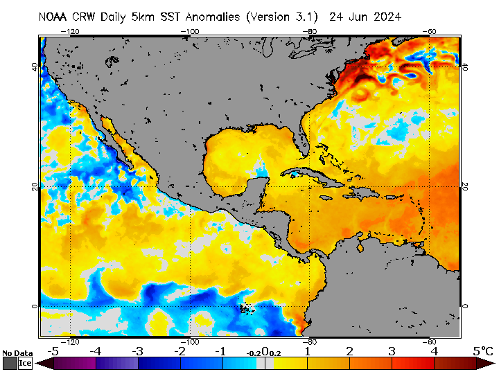
Note that well-above-average SSTs are situated closest to the west coast of peninsular Florida, especially the Tampa Bay Area.
1 likes
CVW / MiamiensisWx / Shell Mound
The posts in this forum are NOT official forecasts and should not be used as such. They are just the opinion of the poster and may or may not be backed by sound meteorological data. They are NOT endorsed by any professional institution or STORM2K. For official information, please refer to products from the NHC and NWS.
-
AnnularCane

- S2K Supporter
- Posts: 2964
- Joined: Thu Jun 08, 2006 9:18 am
- Location: Wytheville, VA
Re: Area of disturbed weather entering the Caribbean
TheStormExpert wrote:Shell Mound wrote:TheStormExpert wrote:For once the para-GFS isn’t showing a crazy solution.
Watch the models trend toward a FL-centric solution, given that most members are showing both a) TCG and b) CA impacts in the medium term. This is not the usual situation in which models are showing landfall(s) on FL in the very distant future. Consensus shows TCG and landfall in the medium term, not further out. The track may well be in line with that of early to mid October (meaning threats to peninsular FL) instead of early November (CA and/or Jamaica, eastern Cuba, the Bahamas...), given that this season has been delayed or “backloaded.” Note that both the EPS/G(E)FS, including the parallel GFS suite(s), indicate the potential for a rapidly intensifying system at the time of closest approach to CA. If the system were instead moving slowly offshore at that time, then the potential for a significantly stronger system would be exponentially higher. Only a very small margin of error would result in yet another late-season major hurricane, possibly a Cat-5 system. The members that do take this system northward toward western Cuba all show significant deepening.
Even if they trend towards a Florida solution as gatorcane mentioned, there will be way too much dry air over the Gulf and Florida for anything of significance to affect the state. Of course that could change but being it’ll be November and fronts are successfully moving through the Gulf and Florida climatology doesn’t favor a hurricane hit on Florida or anywhere in the continental U.S. for that matter.
Zeta says thanks for the laugh, she needed it.
0 likes
-
CyclonicFury
- Category 5
- Posts: 2038
- Age: 27
- Joined: Sun Jul 02, 2017 12:32 pm
- Location: NC
- Contact:
Re: Area of disturbed weather entering the Caribbean
The 700 and 850 mb vorticity signatures are already impressive. I think this could develop sooner than anticipated. I imagine we'll see an invest soon
3 likes
NCSU B.S. in Meteorology Class of 2021. Tropical weather blogger at http://www.cyclonicfury.com. My forecasts and thoughts are NOT official, for official forecasts please consult the National Hurricane Center.
-
cycloneye

- Admin

- Posts: 149719
- Age: 69
- Joined: Thu Oct 10, 2002 10:54 am
- Location: San Juan, Puerto Rico
Re: Area of disturbed weather entering the Caribbean
0 likes
Visit the Caribbean-Central America Weather Thread where you can find at first post web cams,radars
and observations from Caribbean basin members Click Here
and observations from Caribbean basin members Click Here