Area of disturbed weather entering the Caribbean (Is Invest 96L)
Moderator: S2k Moderators
Forum rules

The posts in this forum are NOT official forecasts and should not be used as such. They are just the opinion of the poster and may or may not be backed by sound meteorological data. They are NOT endorsed by any professional institution or STORM2K. For official information, please refer to products from the National Hurricane Center and National Weather Service.
-
CyclonicFury

- Category 5

- Posts: 2038
- Age: 27
- Joined: Sun Jul 02, 2017 12:32 pm
- Location: NC
- Contact:
Re: Area of disturbed weather entering the Caribbean
It appears as if even if this system goes inland into Central America, it'll be absorbed into a lingering Central American Gyre that could spawn a new low pressure area later. A very complex evolution.
4 likes
NCSU B.S. in Meteorology Class of 2021. Tropical weather blogger at http://www.cyclonicfury.com. My forecasts and thoughts are NOT official, for official forecasts please consult the National Hurricane Center.
-
Loveweather12
- Tropical Storm

- Posts: 136
- Joined: Thu Aug 20, 2020 2:37 pm
Re: Area of disturbed weather entering the Caribbean
TheStormExpert wrote:gatorcane wrote:12Z Euro through 144 hours:
https://i.postimg.cc/7b8pDn3Q/ecmwf-mslpa-Norm-watl-fh0-144.gif
The trough is just not deep enough to pull this north. The NAO remains positive so that lends credence to the deterministic model runs that move future-Eta into CA.
https://i.imgur.com/fDvtg0M.png
Ensembles are different. I don’t know if you’ve been paying attention this season but we cant write off tracks until we get a Decent low to track.
Last edited by Loveweather12 on Thu Oct 29, 2020 1:45 pm, edited 1 time in total.
0 likes

Re: Area of disturbed weather entering the Caribbean
Do you guys think this will be 96L by tomorrow night?
0 likes
Personal Forecast Disclaimer:
The posts in this forum are NOT official forecast and should not be used as such. They are just the opinion of the poster and may or may not be backed by sound meteorological data. They are NOT endorsed by any professional institution or storm2k.org. For official information, please refer to the NHC and NWS products.
The posts in this forum are NOT official forecast and should not be used as such. They are just the opinion of the poster and may or may not be backed by sound meteorological data. They are NOT endorsed by any professional institution or storm2k.org. For official information, please refer to the NHC and NWS products.

-
Hurricaneman

- Category 5
- Posts: 7404
- Age: 45
- Joined: Tue Aug 31, 2004 3:24 pm
- Location: central florida
Re: Area of disturbed weather entering the Caribbean
Blinhart wrote:Do you guys think this will be 96L by tomorrow night?
Could be later today
0 likes
-
Hurricaneman
- Category 5
- Posts: 7404
- Age: 45
- Joined: Tue Aug 31, 2004 3:24 pm
- Location: central florida
Re: Area of disturbed weather entering the Caribbean
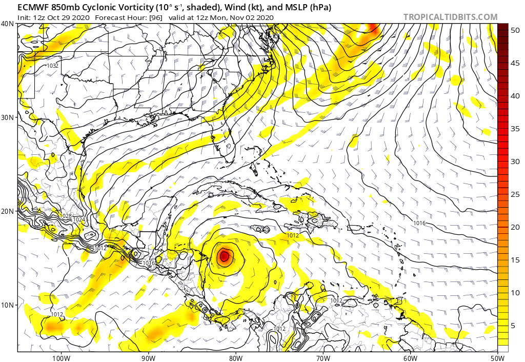
gatorcane wrote:Crossover to EPAC on the Euro:
https://i.postimg.cc/63yWQKS2/ecmwf-uv850-vort-watl-fh96-192.gif
And another area in the Gulf of Honduras which the GFS also does, maybe Eta and Theta from this wave & gyre
0 likes
-
TheStormExpert
Re: Area of disturbed weather entering the Caribbean
Loveweather12 wrote:TheStormExpert wrote:gatorcane wrote:12Z Euro through 144 hours:
https://i.postimg.cc/7b8pDn3Q/ecmwf-mslpa-Norm-watl-fh0-144.gif
The trough is just not deep enough to pull this north. The NAO remains positive so that lends credence to the deterministic model runs that move future-Eta into CA.
https://i.imgur.com/fDvtg0M.png
Ensembles are different. I don’t know if you’ve been paying attention this season but we cant write off tracks until we get a Decent low to track.
We do have an area. It’s getting ready to move through the Windward Islands.
0 likes
-
supercane4867
- Category 5
- Posts: 4966
- Joined: Wed Nov 14, 2012 10:43 am
Re: Area of disturbed weather entering the Caribbean
Just because it crossed over into EPAC doesn't necessarily mean it can't go back to the Atlantic side...
2 likes
-
TheStormExpert
Re: Area of disturbed weather entering the Caribbean
gatorcane wrote:Crossover to EPAC on the Euro:
https://i.postimg.cc/63yWQKS2/ecmwf-uv850-vort-watl-fh96-192.gif
Looks very much like Hurricane Otto from 2016.
1 likes
Re: Area of disturbed weather entering the Caribbean
gatorcane wrote:
12Z Euro through 144 hours:
https://i.postimg.cc/7b8pDn3Q/ecmwf-mslpa-Norm-watl-fh0-144.gif
12Z Euro 5 day qpf:

Last edited by LarryWx on Thu Oct 29, 2020 1:55 pm, edited 1 time in total.
0 likes
Personal Forecast Disclaimer:
The posts in this forum are NOT official forecasts and should not be used as such. They are just the opinion of the poster and may or may not be backed by sound meteorological data. They are NOT endorsed by any professional institution or storm2k.org. For official information, please refer to the NHC and NWS products.
The posts in this forum are NOT official forecasts and should not be used as such. They are just the opinion of the poster and may or may not be backed by sound meteorological data. They are NOT endorsed by any professional institution or storm2k.org. For official information, please refer to the NHC and NWS products.
-
Loveweather12
- Tropical Storm
- Posts: 136
- Joined: Thu Aug 20, 2020 2:37 pm
Re: Area of disturbed weather entering the Caribbean
As I have said and will keep saying. We can’t write off possible tracks for a storm that doesn’t have a low yet. I’ve seen members write off storms before and then these storms form. I’ve been guilty myself.
Thanks & respect to those who do the hard work of presenting every option accurately & present all options.
It’ll be interesting to see where this storm goes.
Thanks & respect to those who do the hard work of presenting every option accurately & present all options.
It’ll be interesting to see where this storm goes.
2 likes
-
Iceresistance

- Category 5
- Posts: 9606
- Age: 22
- Joined: Sat Oct 10, 2020 9:45 am
- Location: Tecumseh, OK/Norman, OK
Re: Area of disturbed weather entering the Caribbean
The NHC has this at 20-60%
0 likes
Bill 2015 & Beta 2020
Winter 2020-2021
All observations are in Tecumseh, OK unless otherwise noted.
Winter posts are focused mainly for Oklahoma & Texas.
Take any of my forecasts with a grain of salt, refer to the NWS, SPC, and NHC for official information
Never say Never with weather! Because ANYTHING is possible!
Winter 2020-2021
All observations are in Tecumseh, OK unless otherwise noted.
Winter posts are focused mainly for Oklahoma & Texas.
Take any of my forecasts with a grain of salt, refer to the NWS, SPC, and NHC for official information
Never say Never with weather! Because ANYTHING is possible!
-
Iceresistance
- Category 5
- Posts: 9606
- Age: 22
- Joined: Sat Oct 10, 2020 9:45 am
- Location: Tecumseh, OK/Norman, OK
Re: Area of disturbed weather entering the Caribbean
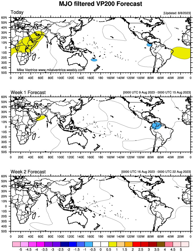
The MJO is all out rising air for the next 2 weeks.
0 likes
Bill 2015 & Beta 2020
Winter 2020-2021
All observations are in Tecumseh, OK unless otherwise noted.
Winter posts are focused mainly for Oklahoma & Texas.
Take any of my forecasts with a grain of salt, refer to the NWS, SPC, and NHC for official information
Never say Never with weather! Because ANYTHING is possible!
Winter 2020-2021
All observations are in Tecumseh, OK unless otherwise noted.
Winter posts are focused mainly for Oklahoma & Texas.
Take any of my forecasts with a grain of salt, refer to the NWS, SPC, and NHC for official information
Never say Never with weather! Because ANYTHING is possible!
-
SFLcane

- S2K Supporter

- Posts: 10281
- Age: 48
- Joined: Sat Jun 05, 2010 1:44 pm
- Location: Lake Worth Florida
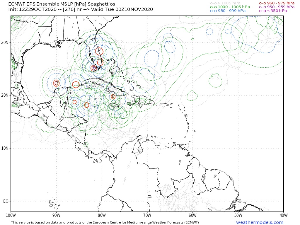
Re: Area of disturbed weather entering the Caribbean
Last edited by SFLcane on Thu Oct 29, 2020 2:21 pm, edited 1 time in total.
3 likes
-
Iceresistance
- Category 5
- Posts: 9606
- Age: 22
- Joined: Sat Oct 10, 2020 9:45 am
- Location: Tecumseh, OK/Norman, OK
Re: Area of disturbed weather entering the Caribbean
All out MJO rising air is expected as well
0 likes
Bill 2015 & Beta 2020
Winter 2020-2021
All observations are in Tecumseh, OK unless otherwise noted.
Winter posts are focused mainly for Oklahoma & Texas.
Take any of my forecasts with a grain of salt, refer to the NWS, SPC, and NHC for official information
Never say Never with weather! Because ANYTHING is possible!
Winter 2020-2021
All observations are in Tecumseh, OK unless otherwise noted.
Winter posts are focused mainly for Oklahoma & Texas.
Take any of my forecasts with a grain of salt, refer to the NWS, SPC, and NHC for official information
Never say Never with weather! Because ANYTHING is possible!
-
AutoPenalti
- Category 5
- Posts: 4091
- Age: 29
- Joined: Mon Aug 17, 2015 4:16 pm
- Location: Ft. Lauderdale, Florida
Re: Area of disturbed weather entering the Caribbean
https://twitter.com/webberweather/status/1321890769490370562
https://twitter.com/webberweather/status/1321891908331986946
2 likes
The posts in this forum are NOT official forecasts and should not be used as such. They are just the opinion of the poster and may or may not be backed by sound meteorological data. They are NOT endorsed by any professional institution or STORM2K. For official information, please refer to products from the NHC and NWS.
Model Runs Cheat Sheet:
GFS (5:30 AM/PM, 11:30 AM/PM)
HWRF, GFDL, UKMET, NAVGEM (6:30-8:00 AM/PM, 12:30-2:00 AM/PM)
ECMWF (1:45 AM/PM)
TCVN is a weighted averaged
-
ElectricStorm

- Category 5
- Posts: 5155
- Age: 25
- Joined: Tue Aug 13, 2019 11:23 pm
- Location: Norman, OK
Re: Area of disturbed weather entering the Caribbean
I'm kinda getting some Otto vibes from this... Anyone else?
0 likes
B.S Meteorology, University of Oklahoma '25
Please refer to the NHC, NWS, or SPC for official information.
Please refer to the NHC, NWS, or SPC for official information.

Re: Area of disturbed weather entering the Caribbean
It seems like we are in an aug or sept pattern not almost November. Climatology is totally out the window this year.
0 likes

Re: Area of disturbed weather entering the Caribbean
underthwx wrote:
Once the wave reaches the central or western Carribean, is it expected to be stationary?...
Models have it moving west.
How far north it moves though is the question.
1 likes
Who is online
Users browsing this forum: ljmac75, mixedDanilo.E and 145 guests