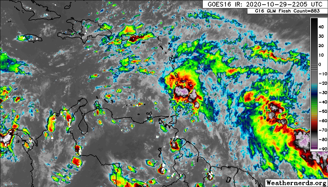
Area of disturbed weather entering the Caribbean (Is Invest 96L)
Moderator: S2k Moderators
Forum rules

The posts in this forum are NOT official forecasts and should not be used as such. They are just the opinion of the poster and may or may not be backed by sound meteorological data. They are NOT endorsed by any professional institution or STORM2K. For official information, please refer to products from the National Hurricane Center and National Weather Service.

Re: Area of disturbed weather entering the Caribbean
If yall take a look at the Lesser Antilles radar yall can see the north to south axis in the rain bands happening as well!
This thing is becoming more and more ominous..
This thing is becoming more and more ominous..
2 likes
-
Hypercane_Kyle

- Category 5

- Posts: 3465
- Joined: Sat Mar 07, 2015 7:58 pm
- Location: Cape Canaveral, FL
Re: Area of disturbed weather entering the Caribbean
18z GFS shifts considerably north. In the western Caribbean by 180 hours.
0 likes
My posts are my own personal opinion, defer to the National Hurricane Center (NHC) and other NOAA products for decision making during hurricane season.
-
Hypercane_Kyle
- Category 5
- Posts: 3465
- Joined: Sat Mar 07, 2015 7:58 pm
- Location: Cape Canaveral, FL
Re: Area of disturbed weather entering the Caribbean
18z GFS looking very Paloma-esque.
0 likes
My posts are my own personal opinion, defer to the National Hurricane Center (NHC) and other NOAA products for decision making during hurricane season.
-
SFLcane

- S2K Supporter

- Posts: 10281
- Age: 48
- Joined: Sat Jun 05, 2010 1:44 pm
- Location: Lake Worth Florida
Re: Area of disturbed weather entering the Caribbean
Oh boy this just got VERY interesting folks.
4 likes
-
SFLcane
- S2K Supporter
- Posts: 10281
- Age: 48
- Joined: Sat Jun 05, 2010 1:44 pm
- Location: Lake Worth Florida
Re: Area of disturbed weather entering the Caribbean
This is exactly what the eps has been harping on for a few runs now. 
1 likes

Re: Area of disturbed weather entering the Caribbean


Last edited by edu2703 on Thu Oct 29, 2020 6:06 pm, edited 1 time in total.
2 likes
-
northjaxpro

- S2K Supporter
- Posts: 8900
- Joined: Mon Sep 27, 2010 11:21 am
- Location: Jacksonville, FL
Re: Area of disturbed weather entering the Caribbean
18Z GFS 288 hr gets future ETA into the Eastern Gulf of Mexico as a major hurricane. It meanders around the NW Gulf of Mexico through 180 hours, then moves northeast , makes landfall on Cuba as a 970 mb cyclone, then moves west northwest around the subtropical ridge. Then it shows a big trough moving from the west lifting the cyclone north then northeast for landfall on Cedar Key in 312 hours..
This is just one run, but definitely an interesting one for sure. I get the feeling this is going to be another long next 7-10 days potentially of tracking another strong Caribbean tropical cyclone. Oh my this insane 2020 just is relentless with these cyclones...
This is just one run, but definitely an interesting one for sure. I get the feeling this is going to be another long next 7-10 days potentially of tracking another strong Caribbean tropical cyclone. Oh my this insane 2020 just is relentless with these cyclones...
Last edited by northjaxpro on Thu Oct 29, 2020 5:54 pm, edited 1 time in total.
6 likes
NEVER, EVER SAY NEVER in the tropics and weather in general, and most importantly, with life itself!!
________________________________________________________________________________________
Fay 2008 Beryl 2012 Debby 2012 Colin 2016 Hermine 2016 Julia 2016 Matthew 2016 Irma 2017 Dorian 2019
________________________________________________________________________________________
Fay 2008 Beryl 2012 Debby 2012 Colin 2016 Hermine 2016 Julia 2016 Matthew 2016 Irma 2017 Dorian 2019

-
cycloneye

- Admin

- Posts: 149719
- Age: 69
- Joined: Thu Oct 10, 2002 10:54 am
- Location: San Juan, Puerto Rico
Re: Area of disturbed weather entering the Caribbean
Code Red 70%

A large area of disturbed weather in the vicinity of the Lesser
Antilles is associated with a tropical wave. Upper-level winds are
expected to become more conducive for development of this
disturbance during the next few days, and a tropical depression is
likely to form by the time the system reaches the western Caribbean
Sea early next week.
* Formation chance through 48 hours...low...30 percent.
* Formation chance through 5 days...high...70 percent.
3 likes
Visit the Caribbean-Central America Weather Thread where you can find at first post web cams,radars
and observations from Caribbean basin members Click Here
and observations from Caribbean basin members Click Here
Re: Area of disturbed weather entering the Caribbean
You could've changed the dates to last week and I wouldve assumed this was Zeta's.
3 likes
Andrew (1992), Irene (1999), Frances (2004), Katrina (2005), Wilma (2005), Fay (2008), Irma (2017), Eta (2020), Ian (2022)
Re: Area of disturbed weather entering the Caribbean
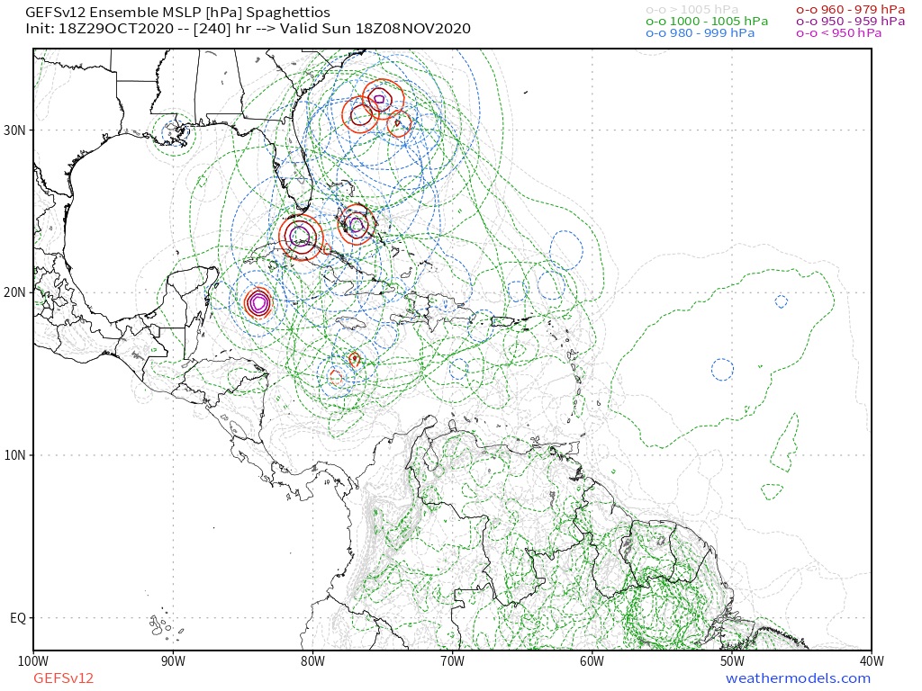
Happy Hour GEFS: this run and others as well as EPS runs have been suggesting that there will be unseasonably intense upper ridging semi-anchored centered over the NE US with a strong surface high of perhaps as strong as 1040 mb also semi-anchored for a few days around Nov 8-10. At the same time, many members have a strong TC moving N or NNE over or near FL that runs into the huge blocking ridge and either stalls it or even turns it W or WSW back into the SE US if offshore. What a crazy setup if this occurs, but it is a strong La Nina with a +AMO and a very warm W Pacific, which combined tends to enhance E US ridging. And of course, it is 2020!

Last edited by LarryWx on Thu Oct 29, 2020 6:38 pm, edited 1 time in total.
2 likes
Personal Forecast Disclaimer:
The posts in this forum are NOT official forecasts and should not be used as such. They are just the opinion of the poster and may or may not be backed by sound meteorological data. They are NOT endorsed by any professional institution or storm2k.org. For official information, please refer to the NHC and NWS products.
The posts in this forum are NOT official forecasts and should not be used as such. They are just the opinion of the poster and may or may not be backed by sound meteorological data. They are NOT endorsed by any professional institution or storm2k.org. For official information, please refer to the NHC and NWS products.
-
jlauderdal
- S2K Supporter
- Posts: 7240
- Joined: Wed May 19, 2004 5:46 am
- Location: NE Fort Lauderdale
- Contact:
Re: Area of disturbed weather entering the Caribbean
i survivedSFLcane wrote:This is exactly what the eps has been harping on for a few runs now.
2 likes
-
SFLcane
- S2K Supporter
- Posts: 10281
- Age: 48
- Joined: Sat Jun 05, 2010 1:44 pm
- Location: Lake Worth Florida
Re: Area of disturbed weather entering the Caribbean
jlauderdal wrote:i survivedSFLcane wrote:This is exactly what the eps has been harping on for a few runs now.3 hour zeta this morning, this one looks far more dangerous..can you imagine we avoid all the systems(we had some weak sauce pass through) this season in sofla until the rare big November cane gets us, that would be so 2020
Far more dangerous yes sir. Again I have had this feeling we are not getting out of this season untouched. Invest coming
0 likes


Re: Area of disturbed weather entering the Caribbean
GFS-Para has not updated on TT. since 0z this morning.
Any other similar link?
Any other similar link?
0 likes

Re: Area of disturbed weather entering the Caribbean
This is just my 2 cents based on what I have seen so far with the past 3 Greek cat2+!!! in a row. While this is early November and water temperatures are lower as a result than peak season, and even for a good chunk of Delta and Zeta's gulf life the water temperatures were lower than what would be expected, abnormally intense troughs have been moving through the CONUS for the past several weeks, bringing freezing conditions all the way to central Texas and resulting in fairly large temperature swings across a good portion of the United States. These troughs have been providing such intense baroclinic enhancement and positive ventilation that we have seen strong hurricanes with Epsilon, Delta, and Zeta over water temperatures of 27-26 degrees, if not lower. I think that clearly the upper level environment has proved very conductive to development recently, and I imagine that if this system gets it's act together it might benefit from a similar interaction. The 18z GFS run shows future Eta clearly merging with a strong angled trough coming through the south, resulting in it's increasing size and outflow as it moves to the East right above Tampa. I honestly think there is an outside shot at another major, especially if atmospheric conditions verify and the ULL/PVS pattern continues to aid intensification rather than hamper it.
2 likes
Re: Area of disturbed weather entering the Caribbean
This 240 hour 12Z EPS map shows many NE US surface highs of stronger than 1036 mb (in yellow). The GEFS is similar. IF this is accurate and IF there is a TC milling about off the SE US coast ~11/8, it would then be stuck and would possibly turn back NW or even W to the SE coast depending on the strength and extent of the ridge. Or if it were then over FL, it could very well turn back west into the Gulf!

Look at the upper ridging spaghetti showing many 588+ dm (in orange) slow moving/blocking 500 mb highs near the US E coast near the time there could be a TC below them:

On the following Happy Hour GEFS 270 hour map, most of the TCs in and near FL are largely then blocked from recurving and in some cases are moving NW, W, or even WSW:

Look at the upper ridging spaghetti showing many 588+ dm (in orange) slow moving/blocking 500 mb highs near the US E coast near the time there could be a TC below them:
On the following Happy Hour GEFS 270 hour map, most of the TCs in and near FL are largely then blocked from recurving and in some cases are moving NW, W, or even WSW:
Last edited by LarryWx on Thu Oct 29, 2020 7:04 pm, edited 1 time in total.
0 likes
Personal Forecast Disclaimer:
The posts in this forum are NOT official forecasts and should not be used as such. They are just the opinion of the poster and may or may not be backed by sound meteorological data. They are NOT endorsed by any professional institution or storm2k.org. For official information, please refer to the NHC and NWS products.
The posts in this forum are NOT official forecasts and should not be used as such. They are just the opinion of the poster and may or may not be backed by sound meteorological data. They are NOT endorsed by any professional institution or storm2k.org. For official information, please refer to the NHC and NWS products.
-
cp79
Re: Area of disturbed weather entering the Caribbean
GFS with another crazy and unrealistic Happy Hour run. Well shouldn’t say unrealistic cause it’s 2020...but this track ain’t happening lol
0 likes
Who is online
Users browsing this forum: CyclonicFury, Sciencerocks and 143 guests