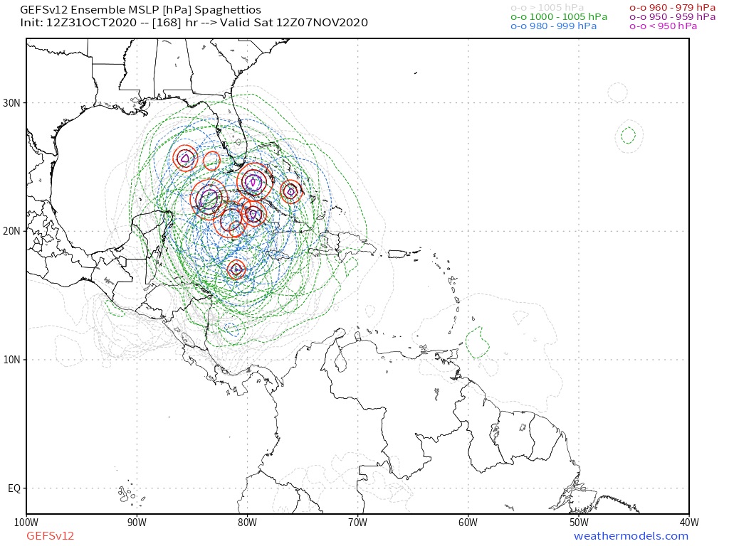
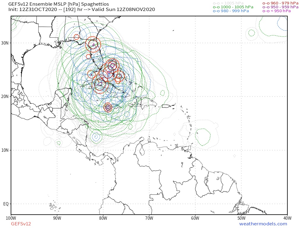
ATL: ETA - Models

Moderator: S2k Moderators

Message
Author
cp79

Re: ATL: INVEST 96L - Models

#301 Postby cp79 » Sat Oct 31, 2020 1:07 pm

gatorcane wrote:HWRF landfall in Nicaragua heading inland. I wouldn’t get too “excited“ about the GFS into Florida unless more good models show it. Inland into CA looks likely.

https://i.postimg.cc/3JpBF8Y7/hwrf-mslp-wind-96-L-fh60-87.gif


Yup. Still think this is most likely solution and then the mountains will crush it.
0 likes   

User avatar
SFLcane
S2K Supporter
S2K Supporter
Posts: 10163
Age: 47
Joined: Sat Jun 05, 2010 1:44 pm
Location: Lake Worth Florida

Re: ATL: INVEST 96L - Models

#302 Postby SFLcane » Sat Oct 31, 2020 1:08 pm

:double:

Image

Image
0 likes   

User avatar
gatorcane
S2K Supporter
S2K Supporter
Posts: 23691
Age: 47
Joined: Sun Mar 13, 2005 3:54 pm
Location: Boca Raton, FL

Re: ATL: INVEST 96L - Models

#303 Postby gatorcane » Sat Oct 31, 2020 1:08 pm

gatorcane wrote:Euro dives SW into Honduras/Nicaragua again. The model is very consistent with this.

Image


Bump
0 likes   

cp79

Re: ATL: INVEST 96L - Models

#304 Postby cp79 » Sat Oct 31, 2020 1:10 pm

Euro and UK both with similar solutions into CA. Feeling safer here in Fla. but still need to keep an eye on it.
0 likes   

User avatar
Blown Away
S2K Supporter
S2K Supporter
Posts: 10145
Joined: Wed May 26, 2004 6:17 am

Re: ATL: INVEST 96L - Models

#305 Postby Blown Away » Sat Oct 31, 2020 1:11 pm

gatorcane wrote:Euro dives SW into Honduras/Nicaragua again. The model is very consistent with this.

https://i.postimg.cc/25vrzBfM/ecmwf-uv850-vort-watl-fh0-72.gif


If the Euro is leaning to GFS it should start some kind of loop SE at @96 hours. GFS doing a loop just off Honduras coast in the @72-96 hour timeframe.
Last edited by Blown Away on Sat Oct 31, 2020 1:13 pm, edited 1 time in total.
2 likes   
Hurricane Eye Experience: David 79, Irene 99, Frances 04, Jeanne 04, Wilma 05... EYE COMING MY WAY IN 2024…
Hurricane Brush Experience: Andrew 92, Erin 95, Floyd 99, Matthew 16, Irma 17, Ian 22, Nicole 22…

User avatar
gatorcane
S2K Supporter
S2K Supporter
Posts: 23691
Age: 47
Joined: Sun Mar 13, 2005 3:54 pm
Location: Boca Raton, FL

Re: ATL: INVEST 96L - Models

#306 Postby gatorcane » Sat Oct 31, 2020 1:11 pm


I remember a similar map with Zeta. The place to be with the GFS is 7+ days out. The chance of it nailing the forecast is slim to none.
0 likes   

Shell Mound
Category 5
Category 5
Posts: 2434
Age: 32
Joined: Thu Sep 07, 2017 3:39 pm
Location: St. Petersburg, FL → Scandinavia

Re: ATL: INVEST 96L - Models

#307 Postby Shell Mound » Sat Oct 31, 2020 1:12 pm

Blown Away wrote:
gatorcane wrote:HWRF landfall in Nicaragua heading inland. I wouldn’t get too excited about the GFS into Florida unless more good models show it. Inland into CA looks likely.

https://i.postimg.cc/3JpBF8Y7/hwrf-mslp-wind-96-L-fh60-87.gif


Agree, but the 12z was a full degree N and model has trended N a bit the last few runs.

Plus, the system is crawling toward land at that point. The ECMWF shows the system being absorbed by the CAG, which seems quite unrealistic. A strong system briefly making landfall while stalling or even executing a counter-clockwise loop seems more plausible than a system that tracks well inland over the mountainous interior of Central America. Taken together, the dynamical models may be slowly converging on a solution that takes a powerful and intensifying 96L (Eta) briefly ashore while stalling and/or looping, shortly before reemerging over the Gulf of Honduras and quickly reorganising again as it tracks toward Cuba and/or Florida.
3 likes   
CVW / MiamiensisWx / Shell Mound
The posts in this forum are NOT official forecasts and should not be used as such. They are just the opinion of the poster and may or may not be backed by sound meteorological data. They are NOT endorsed by any professional institution or STORM2K. For official information, please refer to products from the NHC and NWS.

TallahasseeMan
Tropical Storm
Tropical Storm
Posts: 120
Joined: Sat Aug 01, 2020 1:49 pm

Re: ATL: INVEST 96L - Models

#308 Postby TallahasseeMan » Sat Oct 31, 2020 1:13 pm

Probably gonna need the models to pick up on a closed circulation before we’ll be able to resolve the Euro/GFS split


Sent from my iPhone using Tapatalk
2 likes   
Direct hit: Francis '04, Jeanne '04, Wilma '05 Hermine '16 Michael '18

Outer bands: Katrina '05 Irma '17

User avatar
Jr0d
S2K Supporter
S2K Supporter
Posts: 1409
Joined: Tue Aug 27, 2019 10:52 am
Location: Cayo Hueso

Re: ATL: INVEST 96L - Models

#309 Postby Jr0d » Sat Oct 31, 2020 1:17 pm

cp79 wrote:
kevin wrote:12z GFS goes all-out regarding US impact. Landfalls in Florida, then goes through the entire east coast: Florida, Georgia, South Carolina, North Carolina, Virginia and now Maryland & Delaware at 270 hours. And might I add that Zeta is still 970 mbar at 270 hours, a full day after landfall.


I just don’t know if the steering is there for a Fla landfall to happen. I’m not saying it can’t happen, but if it were to get picked up, I would think it would move more NE, not N. Or WNw and then NW if HP got a hold of it. But maybe they see something I don’t so we’ll see. Like I said, too early in the game to take any model seriously past 96 hrs. The Euro will be interesting in an hour.

All this said, there is a growing and concerning trend for it clipping CA and staying alive and drifting N. Getting closer to 50/50 of that happening.


You said a Florida landfall was .00001% yesterday. Florida was never safe from this, even though it was looking good yesterday. The Florida Peninsula has been extremely lucky for a long time. Even with Irma, had it not took a trip to Cuba, the Florida Keys would have likely had a cat 5 with many communities wiped out like Mexico Beach.

Sooner or later that luck will run out. Hopefully later...

With the Canadian now showing the north turn, we really have to watch this and be prepared.

Also, this board will likely be hyperactive again with the Weather Channel and others showing a possible Florida strike on their tropical updates.

Monday's model runs will have thw recon data inputted, this should give us a much more accurate forecast. It is going to be a busy week, no doubt.
4 likes   

cp79

Re: ATL: INVEST 96L - Models

#310 Postby cp79 » Sat Oct 31, 2020 1:17 pm

Scenario that I think is more likely than Eta moving north is this thing splitting and Theta forming. The mountains could break this system and energy could pull part of it north. I am assuming the storm would get a new name but the Euro has been on this solution for several runs now and I bet it does it with 12z.
0 likes   

User avatar
Spacecoast
Category 2
Category 2
Posts: 758
Joined: Thu Aug 31, 2017 2:03 pm

Re: ATL: INVEST 96L - Models

#311 Postby Spacecoast » Sat Oct 31, 2020 1:20 pm

cp79 wrote:
gatorcane wrote:HWRF landfall in Nicaragua heading inland. I wouldn’t get too “excited“ about the GFS into Florida unless more good models show it. Inland into CA looks likely.

https://i.postimg.cc/3JpBF8Y7/hwrf-mslp-wind-96-L-fh60-87.gif


Yup. Still think this is most likely solution and then the mountains will crush it.


Clearly, there are two camps.. GFS/GFS-P/GEFS are seeing something @72-96 hrs that others are not.

Image
0 likes   

cp79

Re: ATL: INVEST 96L - Models

#312 Postby cp79 » Sat Oct 31, 2020 1:21 pm

Jr0d wrote:
cp79 wrote:
kevin wrote:12z GFS goes all-out regarding US impact. Landfalls in Florida, then goes through the entire east coast: Florida, Georgia, South Carolina, North Carolina, Virginia and now Maryland & Delaware at 270 hours. And might I add that Zeta is still 970 mbar at 270 hours, a full day after landfall.


I just don’t know if the steering is there for a Fla landfall to happen. I’m not saying it can’t happen, but if it were to get picked up, I would think it would move more NE, not N. Or WNw and then NW if HP got a hold of it. But maybe they see something I don’t so we’ll see. Like I said, too early in the game to take any model seriously past 96 hrs. The Euro will be interesting in an hour.

All this said, there is a growing and concerning trend for it clipping CA and staying alive and drifting N. Getting closer to 50/50 of that happening.


You said a Florida landfall was .00001% yesterday. Florida was never safe from this, even though it was looking good yesterday. The Florida Peninsula has been extremely lucky for a long time. Even with Irma, had it not took a trip to Cuba, the Florida Keys would have likely had a cat 5 with many communities wiped out like Mexico Beach.

Sooner or later that luck will run out. Hopefully later...

With the Canadian now showing the north turn, we really have to watch this and be prepared.

Also, this board will likely be hyperactive again with the Weather Channel and others showing a possible Florida strike on their tropical updates.

Monday's model runs will have thw recon data inputted, this should give us a much more accurate forecast. It is going to be a busy week, no doubt.


Part of that was said because the people I disagree with here were, and still are, getting on my nerves, but the other part is I don’t think this is a Fla system and still don’t. In reality I’ve always felt it’s around 1-5% chance. But a piece could break off and head N towards Fla. That scenario I think is more possible and the Euro is on board with it appears. But ETA itself is going into mountains and it won’t survive them.
Last edited by cp79 on Sat Oct 31, 2020 1:23 pm, edited 1 time in total.
0 likes   

User avatar
gatorcane
S2K Supporter
S2K Supporter
Posts: 23691
Age: 47
Joined: Sun Mar 13, 2005 3:54 pm
Location: Boca Raton, FL

Re: ATL: INVEST 96L - Models

#313 Postby gatorcane » Sat Oct 31, 2020 1:22 pm

cp79 wrote:Scenario that I think is more likely than Eta moving north is this thing splitting and Theta forming. The mountains could break this system and energy could pull part of it north. I am assuming the storm would get a new name but the Euro has been on this solution for several runs now and I bet it does it with 12z.


The piece breaking off is possible. Euro 120 hours has 96l into the EPAC with a piece breaking off in the NW Carib. Or maybe the piece is just the disturbed weather near the Lesser Antilles currently.

Image
0 likes   

User avatar
Blown Away
S2K Supporter
S2K Supporter
Posts: 10145
Joined: Wed May 26, 2004 6:17 am

Re: ATL: INVEST 96L - Models

#314 Postby Blown Away » Sat Oct 31, 2020 1:25 pm

GFS spends like 2.5 days drifting around the NE coast of CA, GFS has a history of mid range historic stalls which usually don’t happen. Euro showing its L bias diving SW deep into CA which seems extreme to. Unfortunately for CA a strong hurricane going inland far enough to dissipate while dropping historic rainfall in the mountains looking like likely solution ATM.
Last edited by Blown Away on Sat Oct 31, 2020 1:26 pm, edited 1 time in total.
2 likes   
Hurricane Eye Experience: David 79, Irene 99, Frances 04, Jeanne 04, Wilma 05... EYE COMING MY WAY IN 2024…
Hurricane Brush Experience: Andrew 92, Erin 95, Floyd 99, Matthew 16, Irma 17, Ian 22, Nicole 22…

User avatar
NDG
S2K Supporter
S2K Supporter
Posts: 15446
Joined: Sun Jul 09, 2006 10:14 pm
Location: Orlando, FL

Re: ATL: INVEST 96L - Models

#315 Postby NDG » Sat Oct 31, 2020 1:25 pm

gatorcane wrote:Euro dives SW into Honduras/Nicaragua again. The model is very consistent with this.

https://i.postimg.cc/25vrzBfM/ecmwf-uv850-vort-watl-fh0-72.gif


What doesn't make sense is that it keeps forecasting it to go into the EPAC and for another system to form in the Caribbean side of C.A., it doesn't make any sense. I have never seen that before.
Is either one or the other.
0 likes   

Shell Mound
Category 5
Category 5
Posts: 2434
Age: 32
Joined: Thu Sep 07, 2017 3:39 pm
Location: St. Petersburg, FL → Scandinavia

Re: ATL: INVEST 96L - Models

#316 Postby Shell Mound » Sat Oct 31, 2020 1:26 pm

Blown Away wrote:GFS spends like 2.5 days drifting around the NE coast of CA, GFS has a history of mid range historic stalls which don’t usually happen. Euro showing its L bias diving SW deep into CA which seems extreme to. Unfortunately for CA a strong hurricane going inland far enough to dissipate while dropping historic rainfall in the mountains looking like likely solution ATM.

Virtually all the models agree that 96L (Eta) will be crawling as it nears and makes landfall on Central America. A stall and loop over the coast is synoptically plausible. I am looking at real-time conditions as well as projected ones, and the data indicate, to me at least, that this possibility is very much “on the table,” so to speak, at this point in time. (As for “casting wishes,” just ask toad strangler and CyclonicFury about my traditional anti-Florida bias on this forum. :wink: )
4 likes   
CVW / MiamiensisWx / Shell Mound
The posts in this forum are NOT official forecasts and should not be used as such. They are just the opinion of the poster and may or may not be backed by sound meteorological data. They are NOT endorsed by any professional institution or STORM2K. For official information, please refer to products from the NHC and NWS.

TallahasseeMan
Tropical Storm
Tropical Storm
Posts: 120
Joined: Sat Aug 01, 2020 1:49 pm

Re: ATL: INVEST 96L - Models

#317 Postby TallahasseeMan » Sat Oct 31, 2020 1:29 pm

Jr0d wrote:
cp79 wrote:
kevin wrote:12z GFS goes all-out regarding US impact. Landfalls in Florida, then goes through the entire east coast: Florida, Georgia, South Carolina, North Carolina, Virginia and now Maryland & Delaware at 270 hours. And might I add that Zeta is still 970 mbar at 270 hours, a full day after landfall.


I just don’t know if the steering is there for a Fla landfall to happen. I’m not saying it can’t happen, but if it were to get picked up, I would think it would move more NE, not N. Or WNw and then NW if HP got a hold of it. But maybe they see something I don’t so we’ll see. Like I said, too early in the game to take any model seriously past 96 hrs. The Euro will be interesting in an hour.

All this said, there is a growing and concerning trend for it clipping CA and staying alive and drifting N. Getting closer to 50/50 of that happening.


You said a Florida landfall was .00001% yesterday. Florida was never safe from this, even though it was looking good yesterday. The Florida Peninsula has been extremely lucky for a long time. Even with Irma, had it not took a trip to Cuba, the Florida Keys would have likely had a cat 5 with many communities wiped out like Mexico Beach.

Sooner or later that luck will run out. Hopefully later...

With the Canadian now showing the north turn, we really have to watch this and be prepared.

Also, this board will likely be hyperactive again with the Weather Channel and others showing a possible Florida strike on their tropical updates.

Monday's model runs will have thw recon data inputted, this should give us a much more accurate forecast. It is going to be a busy week, no doubt.

I don’t think it’s fair to go too hard on people for making predictions, it’s what makes this board interesting to read.


Sent from my iPhone using Tapatalk
0 likes   
Direct hit: Francis '04, Jeanne '04, Wilma '05 Hermine '16 Michael '18

Outer bands: Katrina '05 Irma '17

Shell Mound
Category 5
Category 5
Posts: 2434
Age: 32
Joined: Thu Sep 07, 2017 3:39 pm
Location: St. Petersburg, FL → Scandinavia

Re: ATL: INVEST 96L - Models

#318 Postby Shell Mound » Sat Oct 31, 2020 1:31 pm

Regardless of what transpires, given the magnitude of what may be evolving, this “battle of the models” will likely go down in S2K history. As in all time.
Last edited by Shell Mound on Sat Oct 31, 2020 1:31 pm, edited 1 time in total.
0 likes   
CVW / MiamiensisWx / Shell Mound
The posts in this forum are NOT official forecasts and should not be used as such. They are just the opinion of the poster and may or may not be backed by sound meteorological data. They are NOT endorsed by any professional institution or STORM2K. For official information, please refer to products from the NHC and NWS.

cp79

Re: ATL: INVEST 96L - Models

#319 Postby cp79 » Sat Oct 31, 2020 1:31 pm

gatorcane wrote:
cp79 wrote:Scenario that I think is more likely than Eta moving north is this thing splitting and Theta forming. The mountains could break this system and energy could pull part of it north. I am assuming the storm would get a new name but the Euro has been on this solution for several runs now and I bet it does it with 12z.


The piece breaking off is possible. Euro 120 hours has 96l into the EPAC with a piece breaking off in the NW Carib. Or maybe the piece is just the disturbed weather near the Lesser Antilles currently.

https://i.postimg.cc/KcnXRywk/ecmwf-uv850-vort-watl-fh0-120.gif


They’ve been on this solution for a while now and I’m starting to buy it a little. I think their reasoning is the core is going to get stuck in those big mountains and the rest of the energy will pull North and maybe NE. I’ve never seen it happen but it would be interesting to see as long as it pulls to the ENE and out to sea.
0 likes   

User avatar
northjaxpro
S2K Supporter
S2K Supporter
Posts: 8900
Joined: Mon Sep 27, 2010 11:21 am
Location: Jacksonville, FL

Re: ATL: INVEST 96L - Models

#320 Postby northjaxpro » Sat Oct 31, 2020 1:31 pm

gatorcane wrote:
cp79 wrote:Scenario that I think is more likely than Eta moving north is this thing splitting and Theta forming. The mountains could break this system and energy could pull part of it north. I am assuming the storm would get a new name but the Euro has been on this solution for several runs now and I bet it does it with 12z.


The piece breaking off is possible. Euro 120 hours has 96l into the EPAC with a piece breaking off in the NW Carib. Or maybe the piece is just the disturbed weather near the Lesser Antilles currently.

https://i.postimg.cc/KcnXRywk/ecmwf-uv850-vort-watl-fh0-120.gif


Back on Thursday, I mentioned tha the GFS was showing a very intrigiing signifcant energy/vorticity lagging a bit behind Eta. It is possible that area back toward the Lesser Antilles could indeed be a player down the road. Time will tell.
Last edited by northjaxpro on Sat Oct 31, 2020 1:34 pm, edited 1 time in total.
2 likes   
NEVER, EVER SAY NEVER in the tropics and weather in general, and most importantly, with life itself!!

________________________________________________________________________________________

Fay 2008 Beryl 2012 Debby 2012 Colin 2016 Hermine 2016 Julia 2016 Matthew 2016 Irma 2017 Dorian 2019


Return to “2020”

Who is online

Users browsing this forum: No registered users and 4 guests