ATL: ETA - Post-Tropical - Discussion
Moderator: S2k Moderators
-
cp79
Re: ATL: INVEST 96L - Discussion: 2 PM TWO=100%
This may be the most impressive looking “invest” in history. Upgrade it already. It looks like a mid-TS.
0 likes

Re: ATL: INVEST 96L - Discussion: 2 PM TWO=100%
I’m hoping this means we’re getting TD29 or TS Eta at 5.
0 likes
Irene '11 Sandy '12 Hermine '16 5/15/2018 Derecho Fay '20 Isaias '20 Elsa '21 Henri '21 Ida '21
I am only a meteorology enthusiast who knows a decent amount about tropical cyclones. Look to the professional mets, the NHC, or your local weather office for the best information.
I am only a meteorology enthusiast who knows a decent amount about tropical cyclones. Look to the professional mets, the NHC, or your local weather office for the best information.
-
ouragans

- Category 2

- Posts: 501
- Age: 54
- Joined: Sun Jun 12, 2011 12:09 pm
- Location: Abymes, Guadeloupe F.W.I
- Contact:
Re: ATL: INVEST 96L - Discussion
Aric Dunn wrote:Should be upgraded to Eta. at the very least TD.
Clear as day.
https://i.ibb.co/ZL6zZcC/LABELS-19700101-000000-53.gif
https://i.ibb.co/59xwJsk/Capture.png
As usual... you're right
7 likes
Personal forecast disclaimer
This post is a personal point of view, not an information. Please refer to official statements for life-threatening decisions.
David '79, Frederic '79, Hugo '89, Iris, Luis & Marilyn '95, Georges '98, Lenny '99, Dean '07, Irma '17, Maria '17, Fiona '22, Philippe '23, Tammy '23
16°13'33.3,"6N -61°36'39.5"W
-
BYG Jacob
Re: ATL: INVEST 96L - Discussion
wxman57 wrote:Shell Mound wrote:wxman57 wrote:The requirements for a PTC advisory are that there is a high chance of development (check) AND that the potential storm is within 48 hrs of impacting a coastal region that the NHC warns for (nope). Looks like it will reach the coast of Nicaragua Tuesday evening. Therefore, about the earliest we could expect a PTC advisory would be tomorrow late afternoon. However, if you're curious what the NHC track would look like, it would look just like the consensus model (TVCN):
http://wxman57.com/images/TVCN.JPG
Note that the TVCN indicates a significant slowdown just before landfall. 96L may well loop along the coast of Central America and not move far inland at all.
The current rate of intensification means that 96L (Eta) is less likely to move well inland before stalling, looping offshore, and eventually heading northward.
I’m already thinking this could well become a high-end Cat-4 or even low-end Cat-5 before hitting Cabo Gracias a Dios, stalling, and then entering the GoH.*
*Gulf of Honduras
(At any rate, this won’t weaken much, if at all, due to the brevity of its landfall on the relatively flat, marshy Miskito Coast, near the Nicaragua–Honduras line.)
Don’t be shocked if both Central America and Cuba/Florida face the possibility of multiple Cat-4+ landfalls in association with 96L (future Eta).
Yes, I can plot the TVCN hour-by-hour, as indicated below. I think we (forecasters) all want it to just MOVE INLAND AND DIE! (sorry for shouting) We're all ready for a break. Haven't been able to take any vacation days this summer. Myself, I accrued nearly 40 comp DAYS this summer plus I have 20 vacation days left. We are not allowed to carry either over to 2021. So, die, Eta, die!
http://wxman57.com/images/TVCN2.JPG
It would be peak 2020 for Eta to not only rapidly intensify just before landfall, but stay just enough offshore to survive and reintensify
3 likes
-
AutoPenalti
- Category 5

- Posts: 4091
- Age: 29
- Joined: Mon Aug 17, 2015 4:16 pm
- Location: Ft. Lauderdale, Florida
Re: ATL: INVEST 96L - Discussion
I’m thinking NHC might begin to initiate advisories at 5.
0 likes
The posts in this forum are NOT official forecasts and should not be used as such. They are just the opinion of the poster and may or may not be backed by sound meteorological data. They are NOT endorsed by any professional institution or STORM2K. For official information, please refer to products from the NHC and NWS.
Model Runs Cheat Sheet:
GFS (5:30 AM/PM, 11:30 AM/PM)
HWRF, GFDL, UKMET, NAVGEM (6:30-8:00 AM/PM, 12:30-2:00 AM/PM)
ECMWF (1:45 AM/PM)
TCVN is a weighted averaged


Re: ATL: INVEST 96L - Discussion
aspen wrote:At this rate, recon is gonna find a 55-60 kt TS when it arrives tomorrow.
Even finding Eta being a hurricane tomorrow is a possibility. Conditions look good for further development. The only inhibiting factor is it's speed but it should start slowing down soon.
0 likes
-
ouragans
- Category 2
- Posts: 501
- Age: 54
- Joined: Sun Jun 12, 2011 12:09 pm
- Location: Abymes, Guadeloupe F.W.I
- Contact:
Re: ATL: INVEST 96L - Discussion
If there's a TS watch at 21z, we might have Eta by 0z. Unfortunately too late to be counted for october
0 likes
Personal forecast disclaimer
This post is a personal point of view, not an information. Please refer to official statements for life-threatening decisions.
David '79, Frederic '79, Hugo '89, Iris, Luis & Marilyn '95, Georges '98, Lenny '99, Dean '07, Irma '17, Maria '17, Fiona '22, Philippe '23, Tammy '23
16°13'33.3,"6N -61°36'39.5"W
This post is a personal point of view, not an information. Please refer to official statements for life-threatening decisions.
David '79, Frederic '79, Hugo '89, Iris, Luis & Marilyn '95, Georges '98, Lenny '99, Dean '07, Irma '17, Maria '17, Fiona '22, Philippe '23, Tammy '23
16°13'33.3,"6N -61°36'39.5"W
-
cycloneye

- Admin

- Posts: 149508
- Age: 69
- Joined: Thu Oct 10, 2002 10:54 am
- Location: San Juan, Puerto Rico
Re: ATL: INVEST 96L - Discussion
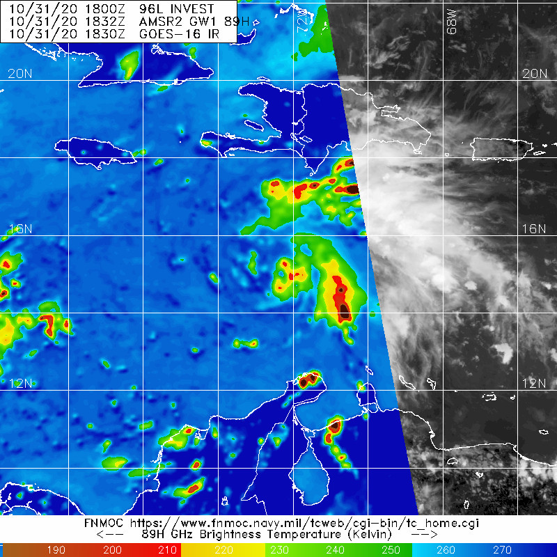
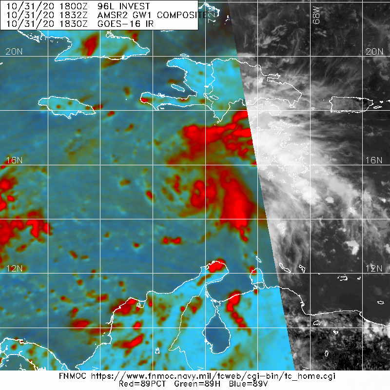
96L INVEST 201031 1800 14.9N 72.4W ATL 30 1006
0 likes
Visit the Caribbean-Central America Weather Thread where you can find at first post web cams,radars
and observations from Caribbean basin members Click Here
and observations from Caribbean basin members Click Here
-
Shell Mound
- Category 5
- Posts: 2432
- Age: 33
- Joined: Thu Sep 07, 2017 3:39 pm
- Location: St. Petersburg, FL → Scandinavia
Re: ATL: INVEST 96L - Discussion
wxman57 wrote:Shell Mound wrote:wxman57 wrote:The requirements for a PTC advisory are that there is a high chance of development (check) AND that the potential storm is within 48 hrs of impacting a coastal region that the NHC warns for (nope). Looks like it will reach the coast of Nicaragua Tuesday evening. Therefore, about the earliest we could expect a PTC advisory would be tomorrow late afternoon. However, if you're curious what the NHC track would look like, it would look just like the consensus model (TVCN):
http://wxman57.com/images/TVCN.JPG
Note that the TVCN indicates a significant slowdown just before landfall. 96L may well loop along the coast of Central America and not move far inland at all.
The current rate of intensification means that 96L (Eta) is less likely to move well inland before stalling, looping offshore, and eventually heading northward.
I’m already thinking this could well become a high-end Cat-4 or even low-end Cat-5 before hitting Cabo Gracias a Dios, stalling, and then entering the GoH.*
*Gulf of Honduras
(At any rate, this won’t weaken much, if at all, due to the brevity of its landfall on the relatively flat, marshy Miskito Coast, near the Nicaragua–Honduras line.)
Don’t be shocked if both Central America and Cuba/Florida face the possibility of multiple Cat-4+ landfalls in association with 96L (future Eta).
Yes, I can plot the TVCN hour-by-hour, as indicated below. I think we (forecasters) all want it to just MOVE INLAND AND DIE! (sorry for shouting) We're all ready for a break. Haven't been able to take any vacation days this summer. Myself, I accrued nearly 40 comp DAYS this summer plus I have 20 vacation days left. We are not allowed to carry either over to 2021. So, die, Eta, die!
http://wxman57.com/images/TVCN2.JPG
Honestly, “heading inland and dying” would be the worst possible outcome in terms of overall impact to Central America, possibly with catastrophic results. Orographic lift would yield torrential rainfall, compounded by slow forward speed, to not mention the impacts of coastal and inland waves as well as intense winds and seiches due to fetch across riparian, coastal lakes and lagoons. At least the U.S., like Cuba, is often better equipped to handle this kind of event. If this system is bound to develop anyway, I would prefer a track offshore to spare Central America from severe impacts. Another Mitch or worse is the very last thing we need. (Not that I’m insinuating anything bad about your intentions, I just want 2020 to minimise overall impacts from this point on.)
9 likes
CVW / MiamiensisWx / Shell Mound
The posts in this forum are NOT official forecasts and should not be used as such. They are just the opinion of the poster and may or may not be backed by sound meteorological data. They are NOT endorsed by any professional institution or STORM2K. For official information, please refer to products from the NHC and NWS.
-
cp79
Re: ATL: INVEST 96L - Discussion
Curious on the Euro solution and how that would transpire...breaking off into two pieces. Are they saying the mountains would tear apart the low and form a new system to the north? Also, this thing is trucking pretty fast and is a notch north of where models initiating it. A notch could mean a ton.
2 likes
-
Do_For_Love
- Category 1

- Posts: 271
- Age: 35
- Joined: Sat May 09, 2015 7:47 am
- Location: Delaware
Re: ATL: INVEST 96L - Discussion
BYG Jacob wrote:It would be peak 2020 for Eta to not only rapidly intensify just before landfall, but stay just enough offshore to survive and reintensify
Followed by movement to the northwest, a brief traverse of the Yucatan, and a then slightly curved track through the gulf and into Louisiana.
5 likes
Irene '11, Sandy '12, Fay '20, Isaias '20, Ida '21

Re: ATL: INVEST 96L - Discussion
ouragans wrote:If there's a TS watch at 21z, we might have Eta by 0z. Unfortunately too late to be counted for october
However, that could help 2020 to break the November record. Tbh I think whatever happens, storm formation will be pushed back to today in post-season analysis.
4 likes

Re: ATL: INVEST 96L - Discussion
It definitely looks like a TS on satellite this afternoon. If we have Eta at 5PM we break the record of named storms for a season. However we still need one more tropical cyclone to break the number of storms in one season that being 2005. Eta will tie us with 2005. We an unamed subtropical storm in 2005. This is 2020 so I expect at least another tropical system will develop in November.
0 likes
The following post is NOT an official forecast and should not be used as such. It is just the opinion of the poster and may or may not be backed by sound meteorological data. It is NOT endorsed by any professional institution including storm2k.org For Official Information please refer to the NHC and NWS products.
-
ElectricStorm

- Category 5
- Posts: 5147
- Age: 25
- Joined: Tue Aug 13, 2019 11:23 pm
- Location: Norman, OK
Re: ATL: INVEST 96L - Discussion
I haven't paid as much attention to 96L today due to the record situation in the WPAC but this looks like a TS to me. I think we'll have Eta at the next advisory
0 likes
B.S Meteorology, University of Oklahoma '25
Please refer to the NHC, NWS, or SPC for official information.
Please refer to the NHC, NWS, or SPC for official information.

-
SouthDadeFish

- Professional-Met

- Posts: 2835
- Joined: Thu Sep 23, 2010 2:54 pm
- Location: Miami, FL
- Contact:
Re: ATL: INVEST 96L - Discussion
I'm guessing this system takes off during the favorable part of the diurnal cycle this evening.
3 likes


Re: ATL: INVEST 96L - Discussion
AutoPenalti wrote:I’m thinking NHC might begin to initiate advisories at 5.
100%/100%?
Count on it.
2 likes
Personal Forecast Disclaimer:
My posts are just my opinion and are most likely not backed by sound meteorological data. They are NOT endorsed by any professional institution or storm2k.org. For official information, please refer to the NHC and NWS products.
Bottom line is that I am just expressing my opinion!!!
My posts are just my opinion and are most likely not backed by sound meteorological data. They are NOT endorsed by any professional institution or storm2k.org. For official information, please refer to the NHC and NWS products.
Bottom line is that I am just expressing my opinion!!!
-
Shell Mound
- Category 5
- Posts: 2432
- Age: 33
- Joined: Thu Sep 07, 2017 3:39 pm
- Location: St. Petersburg, FL → Scandinavia
Re: ATL: INVEST 96L - Discussion
You know it’s 2020 when ASCAT fails to detect a budding hurricane and the EPS caves to the GEFS in the short to medium term...as we are witnessing.
5 likes
CVW / MiamiensisWx / Shell Mound
The posts in this forum are NOT official forecasts and should not be used as such. They are just the opinion of the poster and may or may not be backed by sound meteorological data. They are NOT endorsed by any professional institution or STORM2K. For official information, please refer to products from the NHC and NWS.
Who is online
Users browsing this forum: No registered users and 40 guests