ATL: ETA - Models

Moderator: S2k Moderators

Message
Author
User avatar
Spacecoast
Category 2
Category 2
Posts: 758
Joined: Thu Aug 31, 2017 2:03 pm

Re: ATL: TWENTY-NINE - Models

#401 Postby Spacecoast » Sat Oct 31, 2020 7:18 pm

eastcoastFL wrote:
Spacecoast wrote:18z Spaghetti (courtesy of Tropical Atlantic)...
Euro, & it's ensembles not shown
*many are previous late cycle runs
(white is consensus of all shown)
https://i.ibb.co/pn8M5cr/Capture10031-G.jpg

Same (with model labels)
APxx are GEFS members, AC00 is GEFS control. AVNO is Operational, AEMI is GEFS ensamble mean
https://i.ibb.co/v1z8pyK/Capture10031-H.jpg


What color is AEMI? I see the words but I can’t tell which piece of spaghetti it is.

Dark green, SW of Cayman Islands.
visit here for interactive site (pretty cool site, IMHO,with lots of info, inclding error tracking) :D :
http://tropicalatlantic.com/
2 likes   

User avatar
CyclonicFury
Category 5
Category 5
Posts: 2025
Age: 26
Joined: Sun Jul 02, 2017 12:32 pm
Location: NC
Contact:

Re: ATL: TWENTY-NINE - Models

#402 Postby CyclonicFury » Sat Oct 31, 2020 7:22 pm

The GFS nailed the genesis of this one way out in fantasy land. You have to give the GFS credit for that.
9 likes   
NCSU B.S. in Meteorology Class of 2021. Tropical weather blogger at http://www.cyclonicfury.com. My forecasts and thoughts are NOT official, for official forecasts please consult the National Hurricane Center.

LarryWx
S2K Supporter
S2K Supporter
Posts: 6305
Joined: Sun Sep 07, 2003 2:04 pm
Location: GA

Re: ATL: TWENTY-NINE - Models

#403 Postby LarryWx » Sat Oct 31, 2020 7:24 pm

gatorcane wrote:18Z HWRF goes inland into CA:

https://i.postimg.cc/ZRMfTN93/hwrf-ref-29-L-fh3-90.gif


The 18Z HWRF track is very similar to the 12Z and 0Z, going well inland more or less paralleling the Honduras/Nicaragua border moving WSW. The 6Z was a southern outlier.

Meanwhile, the 18Z Euro, which goes out to only hour 90, is almost identical to its 12Z run.
2 likes   
Personal Forecast Disclaimer:
The posts in this forum are NOT official forecasts and should not be used as such. They are just the opinion of the poster and may or may not be backed by sound meteorological data. They are NOT endorsed by any professional institution or storm2k.org. For official information, please refer to the NHC and NWS products.

edu2703
Category 1
Category 1
Posts: 349
Joined: Thu Aug 23, 2018 7:15 pm

Re: ATL: TWENTY-NINE - Models

#404 Postby edu2703 » Sat Oct 31, 2020 7:30 pm

18z HMON recurves over NE Honduras and seems to make a 2nd landfall in Belize

Image
0 likes   

User avatar
Nimbus
Category 5
Category 5
Posts: 5300
Joined: Mon Jul 19, 2004 10:54 am

Re: ATL: TWENTY-NINE - Models

#405 Postby Nimbus » Sat Oct 31, 2020 7:33 pm

CyclonicFury wrote:The GFS nailed the genesis of this one way out in fantasy land. You have to give the GFS credit for that.


We should know if there is going to be much leftover monsoonal energy in the Caribbean which would validate the current GFS scenario within 42 hours. A stronger tighter system is going to produce a lot of shear with its inflow for any competing system. Princess HWRF may be exaggerating the pressure drop down in the 940's, but once that unwinds over land beyond 5 days or so we get a second chance to look at the Caribbean environment.
1 likes   

User avatar
aspen
Category 5
Category 5
Posts: 8818
Joined: Sat Oct 12, 2019 7:10 pm
Location: Connecticut, USA

Re: ATL: TWENTY-NINE - Models

#406 Postby aspen » Sat Oct 31, 2020 7:41 pm

CyclonicFury wrote:The GFS nailed the genesis of this one way out in fantasy land. You have to give the GFS credit for that.

It also predicted Gamma, Delta, and Zeta around 7-16 days out. It’s like it’s trying to redeem itself for completely failing to form Hanna.
2 likes   
Irene '11 Sandy '12 Hermine '16 5/15/2018 Derecho Fay '20 Isaias '20 Elsa '21 Henri '21 Ida '21

I am only a meteorology enthusiast who knows a decent amount about tropical cyclones. Look to the professional mets, the NHC, or your local weather office for the best information.

User avatar
gatorcane
S2K Supporter
S2K Supporter
Posts: 23691
Age: 47
Joined: Sun Mar 13, 2005 3:54 pm
Location: Boca Raton, FL

Re: ATL: TWENTY-NINE - Models

#407 Postby gatorcane » Sat Oct 31, 2020 7:44 pm

ronjon wrote:18z NAVGEM into the northern coast of Honduras and then North riding up the coast of eastern Yuc.

https://www.tropicaltidbits.com/analysis/models/?model=navgem&region=watl&pkg=mslp_pcpn&runtime=2020103118&fh=54


You can go out farther on fnmoc site. Armageddon with a mammoth hurricane for South Florida but it is the NAVGEM :lol: :eek:

Image
3 likes   

User avatar
Blown Away
S2K Supporter
S2K Supporter
Posts: 10145
Joined: Wed May 26, 2004 6:17 am

Re: ATL: TWENTY-NINE - Models

#408 Postby Blown Away » Sat Oct 31, 2020 7:57 pm

edu2703 wrote:-removed- is defined by the act of interpreting information or a situation in a way that casts it as favorable or desired. I think some here interpret -removed- as only wanting a strong hurricane to pass over a populated area and cause a lot of damage despite the official forecast shows otherwise. The opposite can also be clearly defined as -removed-

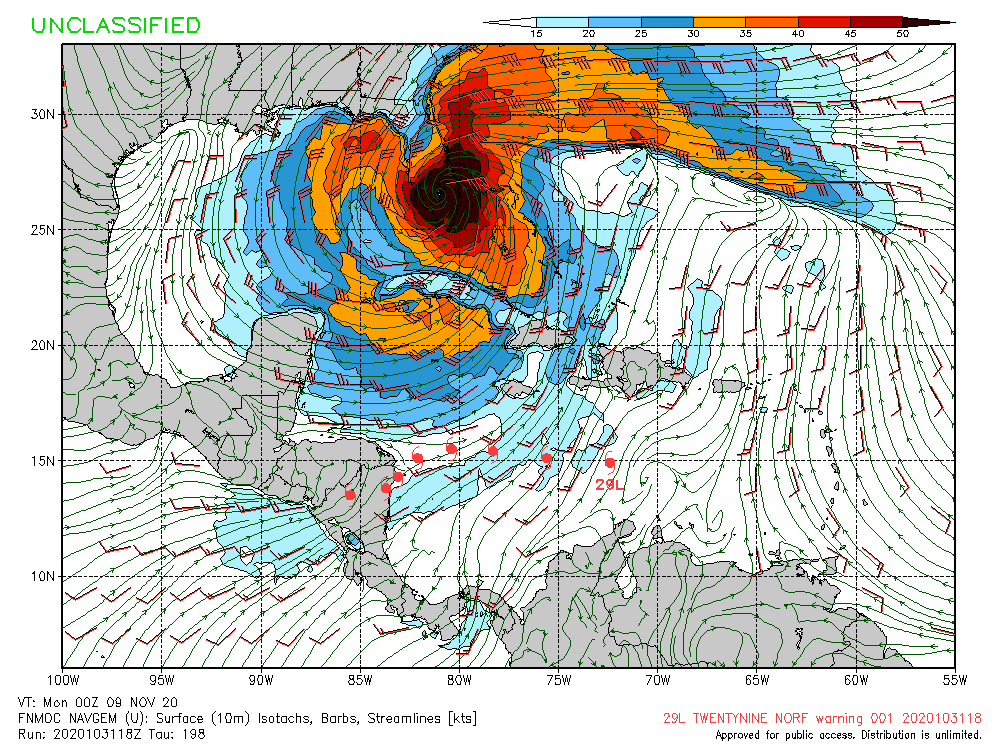
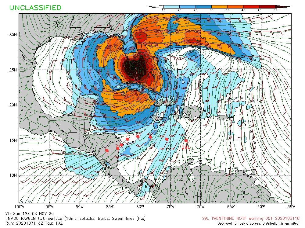
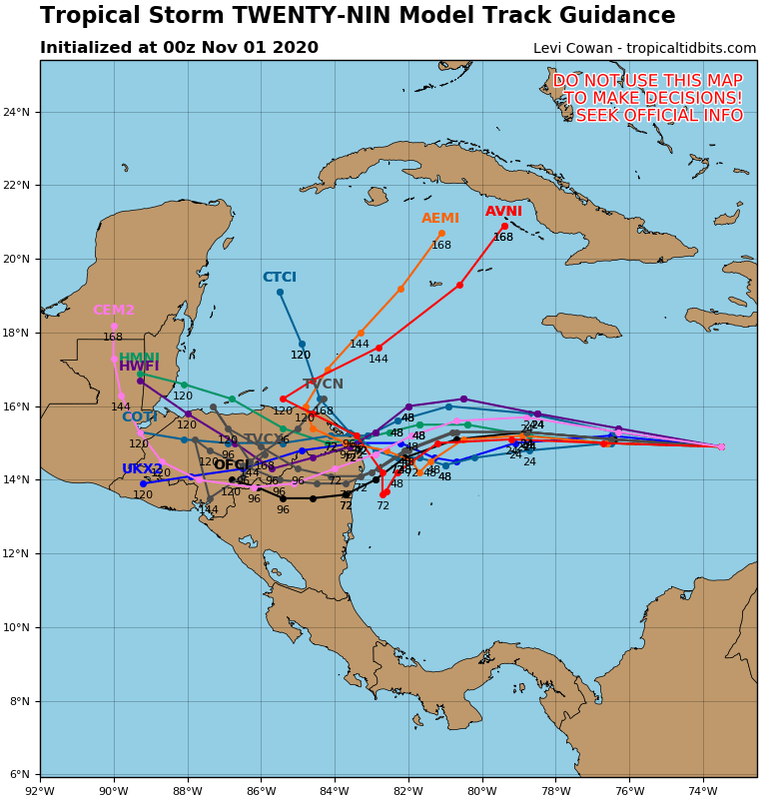
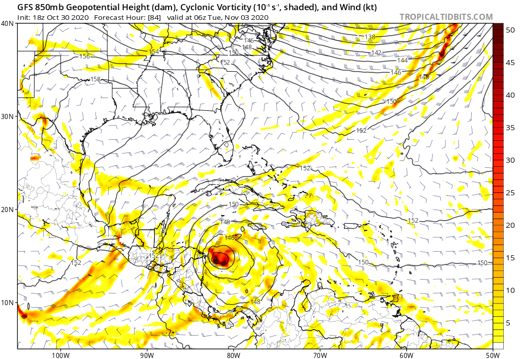
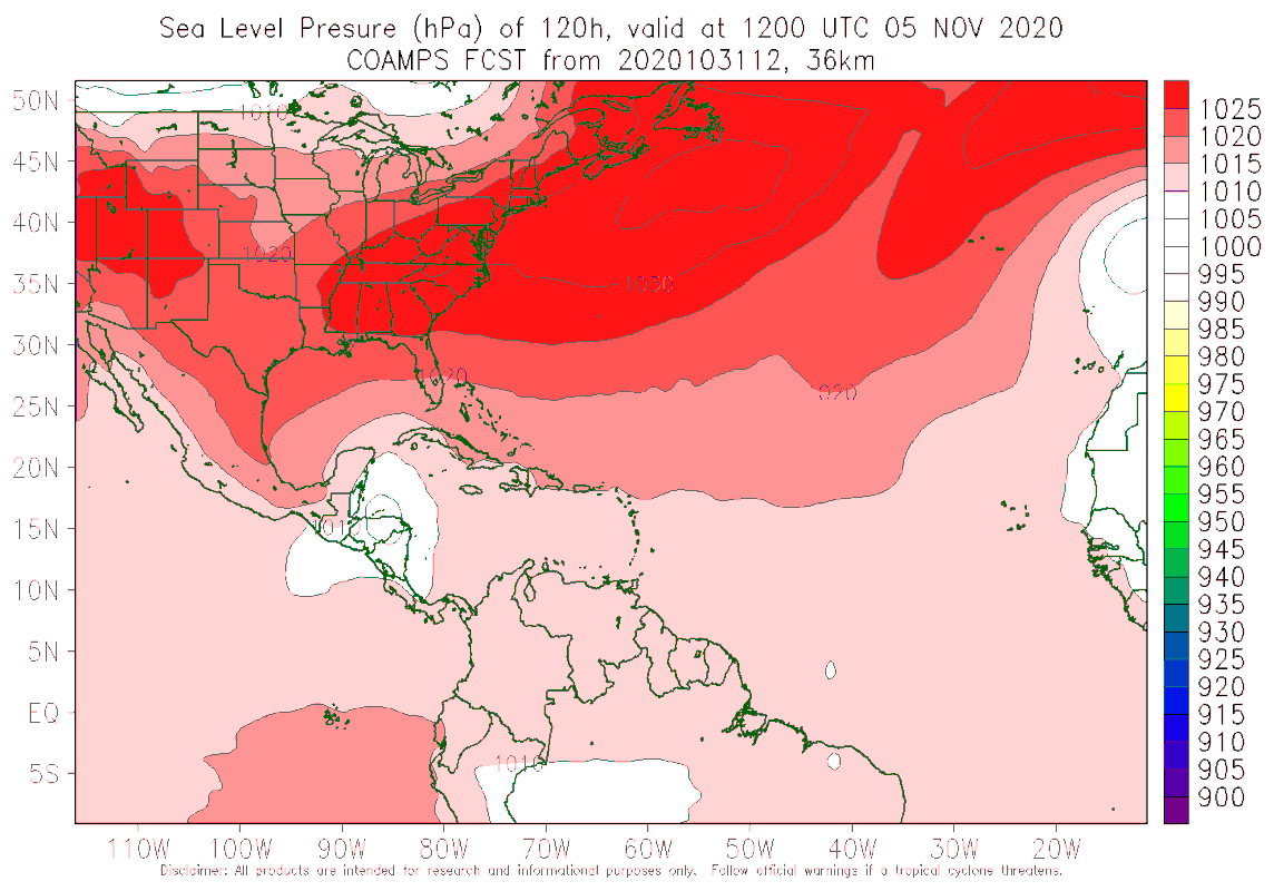
I think certain forum members seriously lack impartiality in model analysis when models shows a storm hitting their state or hometown and is always the same ones. This kind of attitude basically kills any chance of having a civilized discussion. NHC says there is a low confidence in track forecast due to a divergence in the models starting after 48 hours, so, there are several possibile outcomes for this storm even in short term. At this point, to say what this storm will or won't do in long run or saying that place X is safe is extremely premature. A lot can change in the coming days.


I hear you, but no Florida folks are -removed-, Storm2k is very lucky to have the folks your accusing of -removed- on this board because many of us from Florida provide interesting and informative info on all storms. I think Florida folks get unfairly accused of only caring about Florida when many of us spend time preparing posts with informative graphics, model runs, and opinions regardless of where the storm is going. The Florida folks you think are -removed- you will find involved in pretty much every storm this season. I will say that nearly all the Louisiana members are non existent when it doesn’t effect Louisiana. Sorry for the rant.
7 likes   
Hurricane Eye Experience: David 79, Irene 99, Frances 04, Jeanne 04, Wilma 05... EYE COMING MY WAY IN 2024…
Hurricane Brush Experience: Andrew 92, Erin 95, Floyd 99, Matthew 16, Irma 17, Ian 22, Nicole 22…

cp79

Re: ATL: TWENTY-NINE - Models

#409 Postby cp79 » Sat Oct 31, 2020 7:57 pm

TheProfessor wrote:
cp79 wrote:
TheProfessor wrote:
It's not -removed- when there's actual evidence and support towards a solution. The GFS, GEFS, and CMC all support some kind of northward or northwest movement after the southern dive within the next 4-5 days, which isn't fantasy land. It's a legit scenario and depends on the strength of the system and timing of that shortwave trough over Louisiana. If it's earlier and or stronger it could very well prevent a CA landfall. The same goes for a stronger 29 and possibly feeling that weakness. What happens after that has many different ranges, but it's nonsense to chalk up these GFS runs as -removed- when they synoptic setup very well could allow for something similar and when there's currently ensemble support.


I don’t want to get into any fights. But it’s -removed- when people take 1 run run out of 100 that’s more than 7 days out and start drawing attention to Florida and how it’s time to panic. Like seriously. Relax. Let’s just focus on the next 3-4 days. That’s all I’m saying.


It hasn't been one run though, it's been 5 runs with GEFS support.


I understand. I apologize. I didn’t mean to sound mean or anything. I just want to talk weather. I just get a little jumpy when talking so far out and taking it too seriously. I like to focus more on the short. I’m really interested in this system and am really looking forward what comes of it.
.
0 likes   

User avatar
SFLcane
S2K Supporter
S2K Supporter
Posts: 10163
Age: 47
Joined: Sat Jun 05, 2010 1:44 pm
Location: Lake Worth Florida

Re: ATL: TWENTY-NINE - Models

#410 Postby SFLcane » Sat Oct 31, 2020 8:11 pm

:eek:

Image
0 likes   

cp79

Re: ATL: TWENTY-NINE - Models

#411 Postby cp79 » Sat Oct 31, 2020 8:18 pm


A lot of these models taking to SFl are gonna depend on steering and timing. I really think it’s too early to gauge because for it to hit Fla, a perfect storm of dominos would have to fall. There will be a Trough followed by a HP and then another trough. How far those dig and where they are positioned are just really hard to estimate thus far out. First things first is you need to see if it will survive CA.
0 likes   

User avatar
gatorcane
S2K Supporter
S2K Supporter
Posts: 23691
Age: 47
Joined: Sun Mar 13, 2005 3:54 pm
Location: Boca Raton, FL

Re: ATL: TWENTY-NINE - Models

#412 Postby gatorcane » Sat Oct 31, 2020 8:25 pm

00Z guidance, most models deep into CA, NHC track (OFCI) on the south side by a bit:

Image
0 likes   

User avatar
Blown Away
S2K Supporter
S2K Supporter
Posts: 10145
Joined: Wed May 26, 2004 6:17 am

Re: ATL: TWENTY-NINE - Models

#413 Postby Blown Away » Sat Oct 31, 2020 8:28 pm

gatorcane wrote:00Z guidance, most models deep into CA, NHC track (OFCI) on the south side by a bit:

https://i.postimg.cc/43q1hg5H/29-L-tracks-00z.png


The NHC is the southern outlier on the 00z early guidance.
0 likes   
Hurricane Eye Experience: David 79, Irene 99, Frances 04, Jeanne 04, Wilma 05... EYE COMING MY WAY IN 2024…
Hurricane Brush Experience: Andrew 92, Erin 95, Floyd 99, Matthew 16, Irma 17, Ian 22, Nicole 22…

User avatar
gatorcane
S2K Supporter
S2K Supporter
Posts: 23691
Age: 47
Joined: Sun Mar 13, 2005 3:54 pm
Location: Boca Raton, FL

Re: ATL: TWENTY-NINE - Models

#414 Postby gatorcane » Sat Oct 31, 2020 8:37 pm

GFS trend last 5 runs, Further west into CA trend:

Image
0 likes   

User avatar
aspen
Category 5
Category 5
Posts: 8818
Joined: Sat Oct 12, 2019 7:10 pm
Location: Connecticut, USA

Re: ATL: TWENTY-NINE - Models

#415 Postby aspen » Sat Oct 31, 2020 8:41 pm

gatorcane wrote:GFS trend last 5 runs, Further west into CA trend:

https://i.postimg.cc/VvBTR6GV/gfs-z850-vort-watl-fh60-trend.gif

I won’t really care about trends until we have a better idea on how strong Eta becomes and how quickly. Levi said that a stronger storm could be slower and result in a stall over water or just barely on the CA coast, and that the broader monsoonal flow will have an impact as well (and maybe try to form Theta down the line). It’s a very complicated track that should hopefully become clearer once recon goes in tomorrow, determining the rate of intensification, internal structure, and exact direction/speed of Eta.
5 likes   
Irene '11 Sandy '12 Hermine '16 5/15/2018 Derecho Fay '20 Isaias '20 Elsa '21 Henri '21 Ida '21

I am only a meteorology enthusiast who knows a decent amount about tropical cyclones. Look to the professional mets, the NHC, or your local weather office for the best information.

User avatar
gatorcane
S2K Supporter
S2K Supporter
Posts: 23691
Age: 47
Joined: Sun Mar 13, 2005 3:54 pm
Location: Boca Raton, FL

Re: ATL: TWENTY-NINE - Models

#416 Postby gatorcane » Sat Oct 31, 2020 8:43 pm

12Z COAMPS into CA and emerging back over after but weak:

Image
0 likes   

User avatar
cheezyWXguy
Category 5
Category 5
Posts: 6108
Joined: Mon Feb 13, 2006 12:29 am
Location: Dallas, TX

Re: ATL: TWENTY-NINE - Models

#417 Postby cheezyWXguy » Sat Oct 31, 2020 8:45 pm

This -removed- debate is so useless. We need to be honest with ourselves and each other about the uncertainty of the situation and consider all possibilities laid out. This is degrading to the objectivity in analysis the majority of the members of this board strive for.
7 likes   

User avatar
fci
S2K Supporter
S2K Supporter
Posts: 3324
Joined: Tue Sep 14, 2004 10:29 am
Location: Lake Worth, FL

Re: ATL: TWENTY-NINE - Models

#418 Postby fci » Sat Oct 31, 2020 9:17 pm

cp79 wrote:
Loveweather12 wrote:
cp79 wrote:
Sorry people I disagree with...but the 18z Happy Hour GFS is a pipe dream
. It’s not happening lol.


You work for the NHC? Are you an expert that has access to info that we don’t that says a storm isn’t happening?
No one is -removed-. People are being real & showing outcomes for all model runs.


Come on. People are -removed-. It’s so obvious.

As for 28, key is really the interaction with land. I don’t think we can rally forecast past that. We have to see what CA does to it and then reset from there. Let’s focus on the next few days, not 6-7 days out.


You need to stop.
In the past S2K suspended users for using that term.
Perhaps you take it out of your forum vocabulary.
2 likes   
Personal Forecast Disclaimer:
My posts are just my opinion and are most likely not backed by sound meteorological data. They are NOT endorsed by any professional institution or storm2k.org. For official information, please refer to the NHC and NWS products.
Bottom line is that I am just expressing my opinion!!!

User avatar
Blown Away
S2K Supporter
S2K Supporter
Posts: 10145
Joined: Wed May 26, 2004 6:17 am

Re: ATL: TWENTY-NINE - Models

#419 Postby Blown Away » Sat Oct 31, 2020 9:30 pm

cheezyWXguy wrote:This -removed- debate is so useless. We need to be honest with ourselves and each other about the uncertainty of the situation and consider all possibilities laid out. This is degrading to the objectivity in analysis the majority of the members of this board strive for.


I agree, but if your on this board a lot there are many shots taken at Florida posters for being people I disagree with, when those folks provide posts on nearly all the storms. CA is in the bullseye for a potential hurricane stalling along the coast creating tremendous rainfall/landslides in those mountains, we all know that and are concerned, but talking about what may happen after that is not -removed-.
1 likes   
Hurricane Eye Experience: David 79, Irene 99, Frances 04, Jeanne 04, Wilma 05... EYE COMING MY WAY IN 2024…
Hurricane Brush Experience: Andrew 92, Erin 95, Floyd 99, Matthew 16, Irma 17, Ian 22, Nicole 22…

User avatar
blp
Category 5
Category 5
Posts: 2840
Age: 46
Joined: Thu Sep 09, 2004 7:51 pm
Location: Miami, FL
Contact:

Re: ATL: TWENTY-NINE - Models

#420 Postby blp » Sat Oct 31, 2020 9:33 pm

fci wrote:
cp79 wrote:
Loveweather12 wrote:
You work for the NHC? Are you an expert that has access to info that we don’t that says a storm isn’t happening?
No one is -removed-. People are being real & showing outcomes for all model runs.


Come on. People are -removed-. It’s so obvious.

As for 28, key is really the interaction with land. I don’t think we can rally forecast past that. We have to see what CA does to it and then reset from there. Let’s focus on the next few days, not 6-7 days out.


You need to stop.
In the past S2K suspended users for using that term.
Perhaps you take it out of your forum vocabulary.


Agreed, people on this board are free to express their opinions and ideas as long as we are respectful. After all we are all ametuers and are not required to provide objectivity like if we are scientists. Using the term -removed- just like downcasting can be interpreted as a way of silencing one's opinion. If you don't like someone's opinion you can block them and move on.
5 likes   
The following post is NOT an official forecast and should not be used as such. It is just the opinion of the poster and may or may not be backed by sound meteorological data. It is NOT endorsed by any professional institution including storm2k.org For Official Information please refer to the NHC and NWS products.


Return to “2020”

Who is online

Users browsing this forum: No registered users and 1 guest