LarryWx wrote: I can never figure out why these things always come out earlier than many of the actual model runs. Examples: this "0Z" map has AVNI and UKMET, which have yet to be run for 0Z. So, I assume what these spaghetti plots really are are the last runs completed and don't we haven't already talked about.
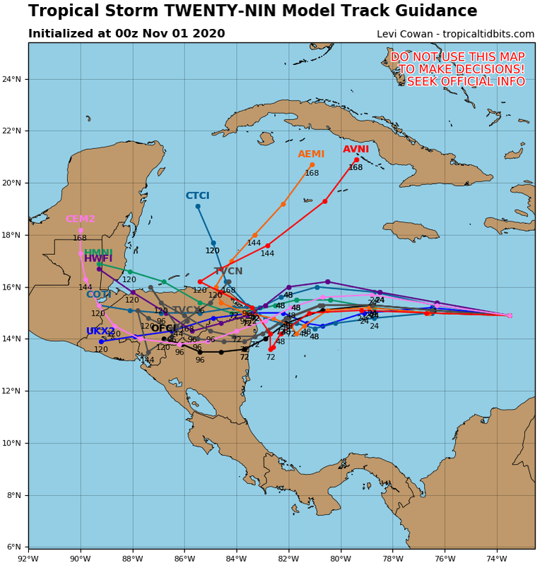
Forecast aids can be categorized as either "early" or "late" depending on when they become available relative in the forecast cycle. At NHC, the forecast aids are initialized at the synoptic times of 00, 06, 12, and 18 UTC. The official forecast is due 3 hours after the synoptic time (so at 03, 09, 15, or 21 UTC).
The simple forecast aids take just minutes to run and are therefore considered as "early" aids since they are available almost immediately and can be used by the forecaster in the current cycle. Early aids include the beta and advection models (BAMS, BAMM, BAMD), the Statistical Hurricane Intensity Prediction Scheme (SHIPS) forecast aids (DSHP and LGEM), the simple barotropic models (e.g. LBAR), and the statistical climatology and persistence aid (e.g. CLP5).
The more complex forecast aids, on the other hand, normally take several hours to run (even on supercomputers!). Because the projections from these forecast aids generally become available several hours into the forecast cycle (and very often after the forecast has gone out), they are termed "late" since they can't be used in the current forecast cycle. To account for this chronic lateness, the output from a 6-hr old late forecast aid is adjusted 6-hr into the "future". As an example, the projected track and intensity from the GFDL model for hours 6-126 is adjusted 6-hr ahead so that it would match the times of an early cycle aid running from 0 to 120 hrs. This allows the forecaster to readily compare its output to the early forecast aids. For historical reasons, the adjustment is often called interpolation (the method of adjustment may differ from a basic linear interpolation however). Thus, the early cycle guidance plots also contain the "interpolated" late models. Any late forecast aids which has been interpolated 6-hr ahead is given a TECH identifier that ends in 'I'. The late models include the global models (e.g. GFS and the UKM) and the high resolution regional models (e.g. HWRF and GFDL). Note: it is also possible to interpolate a late model from 2 forecast cycles ago (12 hrs old). Such models are given a TECH identifier ending in '2'.
OFCI: NHC official forecast from previous forecast cycle (adjusted 6 hours to present cycle
Early cycle track forecast aids:
XTRP: Extrapolation using past 12-hr motion (only shown for first 24-hr)
CLP5: CLImatology and PERsistence model (CLIPER), 5-day version (statistical)
BAMS: Beta and Advection Model, Shallow layer (single layer trajectory model)
BAMM: Beta and Advection Model, Medium layer (single layer trajectory model)
BAMD: Beta and Advection Model, Deep layer (single layer trajectory model)
LBAR: Limited area BARotropic model (single-layer regional dynamical model)
Multilayer global-dynamical models - deterministic runs: GFS Operational,
Late cycle track forecast aids:
AVNI/GFSI: Previous cycle's run of the NWS Global Forecast System (GFS) model
CMCI: Previous cycle's run of the Environment Canada Global Environmental Multiscale (GEM) model
EGRI: Previous cycle's run of the UK Met Office model with subjective quality control applied to the tracker
UKMI: Previous cycle's run of the UK Met Office model using the development tracker (no quality control, only run at 0000 and 1200 UTC)
NGPI: Previous cycle's run of the Navy Operational Global Prediction System (NOGAPS)
Multilayer regional-dynamical models:
HWRI: Previous cycle's run of the NWS/Hurricane Weather Research and Forecasting (HWRF) model
GFDI: Previous cycle's run of the NWS/Geophysical Fluid Dynamics Laboratory (GFDL) model
GFTI: Previous cycle's run of the NWS/GFDL model (using the GFS vortex tracker)
GFNI: Previous cycle's run of the NWS/GFDL model (using the NOGAPS model fields)
COTI: Previous cycle's run of the Navy COAMPS model
Consensus track aids
Finally, the following consensus track aids are plotted on the early cycle track plots. Generally, these are a weighted average of several diverse models, or a simple average of all the ensemble members of a particular ensemble forecasting system. In general, the consensus aids are considered early track aids since they use the interpolated output of the late models.
AEMI: Previous cycle's ensemble mean of the NWS Global Ensemble Forecast System (GEFS) (adjusted 6 hours to present cycle)
TCON: Average of GHMI, EGRI, NGPI, HWFI, and GFSI
TVCA: Variable consensus (weightings can vary) of AVNI/2, EGRI/2, GHMI/2, HWRI/2, EMXI/2, GFNI/2
TVCE: Variable consensus (weightings can vary) of AVNI/2, EGRI/2, NGPI/2, GHMI/2, HWRI/2, EMXI/2, GFNI/2
TV15: Variable consensus (weightings can vary) of various Stream 1.5 models under evaluation by HFIP


