ATL: ETA - Models
Moderator: S2k Moderators
-
otowntiger
- Category 5

- Posts: 1932
- Joined: Tue Aug 31, 2004 7:06 pm
Re: ATL: ETA - Models
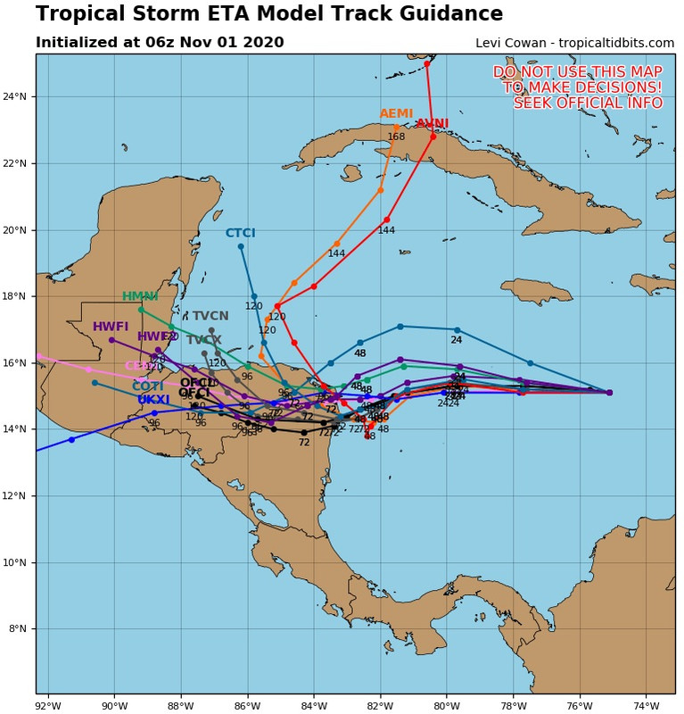
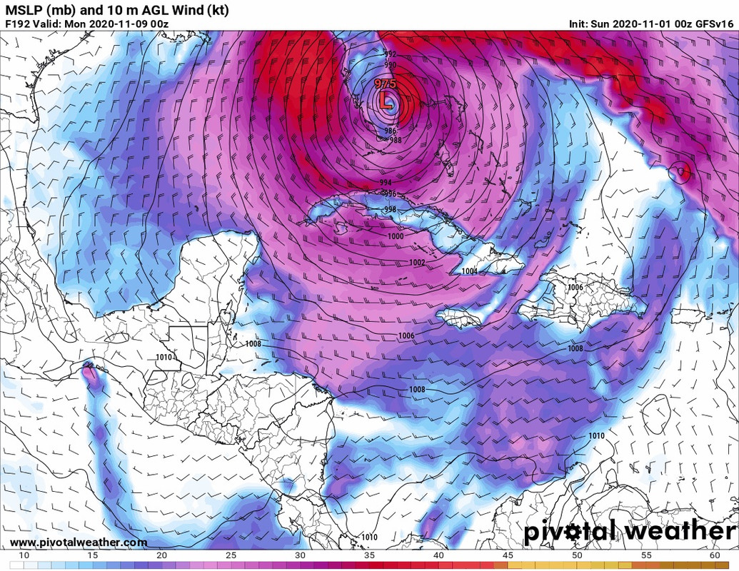
The most recent gfs run makes me think that Louisiana could be in play, yet again. Given its usual right bias gfs pushed Eta very far into the central gulf before sending it back up to the FL panhandle- makes me wonder if the ultimate outcome will be even further west. If so that would be absolutely insane, but not unbelievable for this year.
0 likes
-
AxaltaRacing24
- Category 5
- Posts: 1774
- Age: 25
- Joined: Wed Jul 27, 2016 11:14 am
- Location: Jupiter, FL
Re: ATL: ETA - Models
otowntiger wrote:The most recent gfs run makes me think that Louisiana could be in play, yet again. Given its usual right bias gfs pushed Eta very far into the central gulf before sending it back up to the FL panhandle- makes me wonder if the ultimate outcome will be even further west. If so that would be absolutely insane, but not unbelievable for this year.
i don't even want to think about it. i almost would rather us get it here in sfl than have louisiana get yet another storm.
2 likes
-
Shell Mound
- Category 5
- Posts: 2432
- Age: 33
- Joined: Thu Sep 07, 2017 3:39 pm
- Location: St. Petersburg, FL → Scandinavia
Re: ATL: ETA - Models
blp wrote:SouthFLTropics wrote:blp wrote:
I think this run heads to Florida. I see ridge building in.
Ridge was an understatement...LEFT TURN CLYDE!!! It didn’t even use its turn signal. Typical South Florida driver!!!
Sent from my iPhone using Tapatalk
Wow look at this run so far. That looks more like a happy hour GFS 18z run
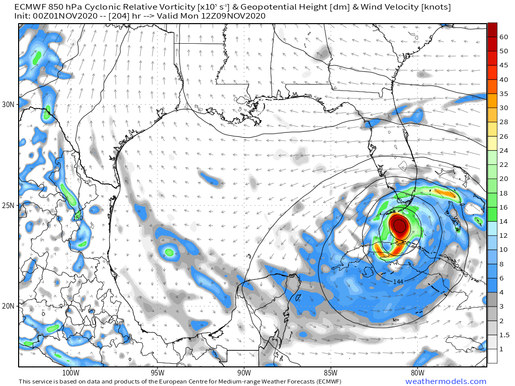
https://i.ibb.co/WgcSzbw/ecmwf-uv850-vort-watl-fh0-216.gif
Based on the H5 charts, steering really breaks down just as Eta makes landfall on this run. The track well inland afterward on this run doesn’t make sense.*
*I am referring to the early portion of the run that affects and pertains to Eta’s interaction with Central America. A stall over the coast is more plausible.
0 likes
CVW / MiamiensisWx / Shell Mound
The posts in this forum are NOT official forecasts and should not be used as such. They are just the opinion of the poster and may or may not be backed by sound meteorological data. They are NOT endorsed by any professional institution or STORM2K. For official information, please refer to products from the NHC and NWS.

Re: ATL: ETA - Models
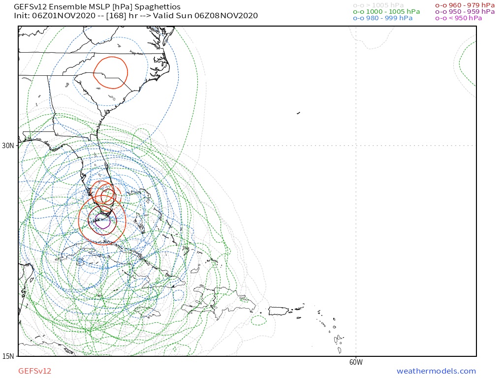
I think we'll have to wait for today's recon mission to get a better idea of the future of Eta. 06z HWRF initialized Eta as a sloppy 1004 mbar, 35 kt system. But tbh I think Eta could already be significantly stronger and better organized at the moment. And even a small adjustment in the level of current organization can have a huge impact on the road (I'm talking cat 1 vs. major hurricane differences).
0 likes
-
SFLcane

- S2K Supporter

- Posts: 10281
- Age: 48
- Joined: Sat Jun 05, 2010 1:44 pm
- Location: Lake Worth Florida
Re: ATL: ETA - Models
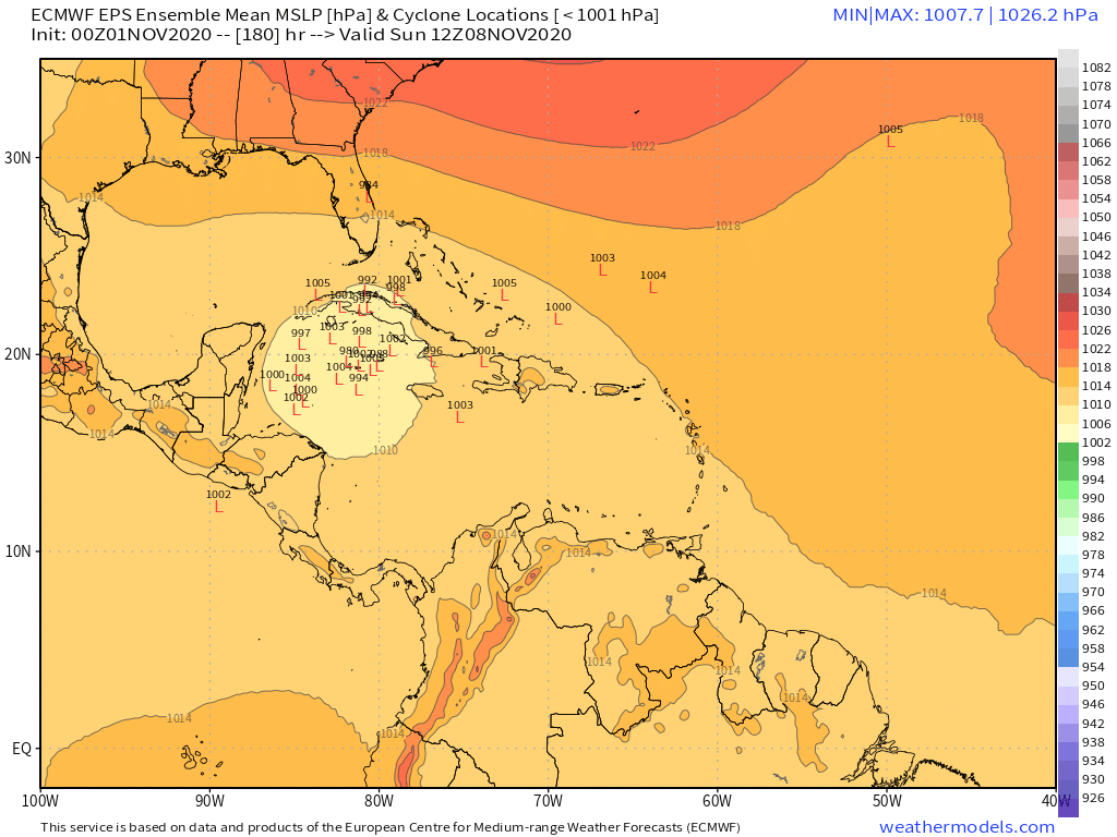
Oh boy I see the euro caved to the gfs and now has a hurricane near SFL.
1 likes
-
TheStormExpert
Re: ATL: ETA - Models
These models just continue to give everyone headaches this year.
0 likes
Re: ATL: ETA - Models
SFLcane wrote:Oh boy I see the euro caved to the gfs and now has a hurricane near SFL.
Do you (or perhaps anyone else) have a screenshot or something from the 06z euro that they're allowed to share? This post got me very worried, when the euro caves it's usually a pretty good sign that something is really going on.
0 likes
-
TheStormExpert
Re: ATL: ETA - Models
As much as it’s interesting to see the Euro show something for once this season. We know it’s going to change especially considering it’s 8-10 days out. I’d much rather see a hurricane near South Florida in that range.
0 likes
-
Keldeo1997
- Category 2

- Posts: 688
- Joined: Fri Oct 11, 2019 11:35 pm
Re: ATL: ETA - Models
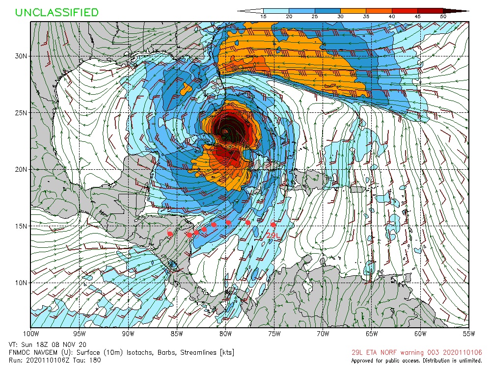
06Z HWRF coming much further East. Doesn't even make it to Central America.

Stalls then starts crawling East
Stalls then starts crawling East
3 likes

Re: ATL: ETA - Models
SFLcane wrote:Oh boy I see the euro caved to the gfs and now has a hurricane near SFL.
The official forecast still keeps Eta inland at 120 hours so they aren't building on the idea of a low forming off Belize yet. 00Z HWRF showed some energy reemerging off Belize at 126 hours. GFS gave up on its loop idea off the coast and brings the storm inland with the official track. HWRF was showing RI just before landfall down to the 930's but 06Z HWRF run has landfall at 66 hours near the border at 948 mb's.
0 likes
-
Weatherboy1

- Category 5
- Posts: 1190
- Age: 50
- Joined: Mon Jul 05, 2004 1:50 pm
- Location: Jupiter/Sarasota, FL
Re: ATL: ETA - Models
SFLcane wrote:here comes the turn tcvn now north the nhc.
https://i.postimg.cc/Y9dMFL7T/C0-BAE7-BE-A647-467-A-8-C7-F-4-DD8819-D64-E5.jpg
Yes, to me it's pretty significant the Euro came around to the GFS solution/general idea vs. the other way around. If this trend continues through the day today, I'll definitely be more concerned about some kind of impact here in FL
2 likes

Re: ATL: ETA - Models
The IR simulation on the GFS and CMC show a weakened and sheared system as it approaches Cuba and Florida. They both have ETA losing a significant of strength over Hondorus, then struggle to regain organization as it moves northeast.
If ETA somehow manages to avoid significant land interaction, I suppose a stronger storm will emerge but may have to battle shear and dry air.
Still a lot of uncertainty. We really need that recon data for the model inputs.
If ETA somehow manages to avoid significant land interaction, I suppose a stronger storm will emerge but may have to battle shear and dry air.
Still a lot of uncertainty. We really need that recon data for the model inputs.
2 likes
Re: ATL: ETA - Models
Looks like the long range forecasts beyond 5 days have a trough or weakness pulling a remnant low out of the Gulf of Honduras north over Cuba but the trough is not strong enough to take it out to sea. Then whatever is left of the storm after the shear tracks west or WSW over south Florida into the gulf of Mexico. Lots of possibilities though, for example a stronger digging trough could take it out to sea.
0 likes
-
DESTRUCTION5

- Category 5
- Posts: 4430
- Age: 44
- Joined: Wed Sep 03, 2003 11:25 am
- Location: Stuart, FL
Re: ATL: ETA - Models
TheStormExpert wrote::uarrow: Of course just when the 06z GFS drops the idea of anything significant coming from this post Central America.
These models just continue to give everyone headaches this year.
Cept for the 35 inches it dumps on east coast of Fl while meandering.
0 likes
GATOR NATION IS E V E R Y W H E R E !
Who is online
Users browsing this forum: No registered users and 16 guests