
ATL: ETA - Models
Moderator: S2k Moderators
-
TheStormExpert
-
Shell Mound
- Category 5

- Posts: 2432
- Age: 33
- Joined: Thu Sep 07, 2017 3:39 pm
- Location: St. Petersburg, FL → Scandinavia
Re: ATL: ETA - Models
Jr0d wrote:The IR simulation on the GFS and CMC show a weakened and sheared system as it approaches Cuba and Florida. They both have ETA losing a significant of strength over Hondorus, then struggle to regain organization as it moves northeast.
If ETA somehow manages to avoid significant land interaction, I suppose a stronger storm will emerge but may have to battle shear and dry air.
Still a lot of uncertainty. We really need that recon data for the model inputs.
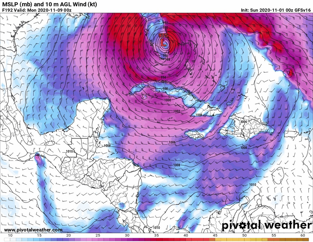
By day three the 06Z GFS shows Eta crawling ashore, then suddenly “jumping” well inland. That seems like convective feedback to me, especially given Zeta is likely to be a powerful system, intensifying as it nears Central America while slowing considerably. It is more likely that a strong Zeta would stall along the Honduran–Nicaraguan coastline or even execute a counterclockwise loop before reemerging over water. Yet some models show Zeta suddenly and unrealistically accelerating and heading inland after nearly stalling on the coastline while subject to weak steering currents all the while. I don’t buy that “inland” solution, personally.
0 likes
CVW / MiamiensisWx / Shell Mound
The posts in this forum are NOT official forecasts and should not be used as such. They are just the opinion of the poster and may or may not be backed by sound meteorological data. They are NOT endorsed by any professional institution or STORM2K. For official information, please refer to products from the NHC and NWS.
-
Shell Mound
- Category 5
- Posts: 2432
- Age: 33
- Joined: Thu Sep 07, 2017 3:39 pm
- Location: St. Petersburg, FL → Scandinavia
Re: ATL: ETA - Models
Keldeo1997 wrote:06Z HWRF coming much further East. Doesn't even make it to Central America.
https://cdn.discordapp.com/attachments/716215692617187328/772421960742207518/hwrf_ref_29L_fh24-54.gif
Stalls then starts crawling East
By day two (forty-eight) hours the 06Z HWRF shows major hurricane Zeta nearly stalling just offshore of Central America, then suddenly accelerating westward well inland over the mountains. I’m sorry, but looking at the mid- to upper-level steering, I don’t see how Zeta would suddenly speed up and head well inland after nearly stalling along the coastline or just offshore. There just aren’t any strong steering currents to take Zeta so far inland. Climatology would support a stall and slow northward drift/turn either on the coast or just offshore, not a slowdown followed by massive acceleration to the west. Also, even the HWRF might be too conservative with the intensity over the next two days, given current convective trends and the extremely conducive environment already emergent. All this would tend to favour a stronger and slower system overcoming its contenders for the foreseeable future.
Anyway, for Central America’s sake, I really hope this somehow stays just offshore and thereby prevents a repeat of Mitch ‘98 or even worse.
2 likes
CVW / MiamiensisWx / Shell Mound
The posts in this forum are NOT official forecasts and should not be used as such. They are just the opinion of the poster and may or may not be backed by sound meteorological data. They are NOT endorsed by any professional institution or STORM2K. For official information, please refer to products from the NHC and NWS.
-
MJGarrison
- Tropical Storm

- Posts: 146
- Joined: Wed Aug 30, 2017 7:26 pm
ATL: ETA - Models
I didn’t really think about it until this morning, but in the US we got out of Daylight Savings Time last night...so the Euro appears to run an hour earlier.
Here is the 6Z Euro

Sent from my iPad using Tapatalk
Here is the 6Z Euro
Sent from my iPad using Tapatalk
Last edited by MJGarrison on Sun Nov 01, 2020 7:26 am, edited 1 time in total.
2 likes

Re: ATL: ETA - Models
HWRF is weaker (~960 mbar instead of 940s), but it still shows a pinhole eye, and it tries to stall Eta just off of the coast or barely on it.
0 likes
Irene '11 Sandy '12 Hermine '16 5/15/2018 Derecho Fay '20 Isaias '20 Elsa '21 Henri '21 Ida '21
I am only a meteorology enthusiast who knows a decent amount about tropical cyclones. Look to the professional mets, the NHC, or your local weather office for the best information.
I am only a meteorology enthusiast who knows a decent amount about tropical cyclones. Look to the professional mets, the NHC, or your local weather office for the best information.
-
jlauderdal
- S2K Supporter

- Posts: 7240
- Joined: Wed May 19, 2004 5:46 am
- Location: NE Fort Lauderdale
- Contact:
Re: ATL: ETA - Models
there will always be a model someplace that plows a hurricane into south Florida...seen this movie for over 20 yearsSFLcane wrote:00z gfs-p brings a hurricane across SFL and into the GOM.
https://i.postimg.cc/ZYxkQdyN/31-EA432-F-83-A3-4068-A6-E9-DC1-D314-E8128.jpg
5 likes
-
Shell Mound
- Category 5
- Posts: 2432
- Age: 33
- Joined: Thu Sep 07, 2017 3:39 pm
- Location: St. Petersburg, FL → Scandinavia
Re: ATL: ETA - Models
MJGarrison wrote:I didn’t really think about it until this morning, but in the US we got out of Daylight Savings Time last night...so the Euro appears to run an hour earlier.
Here is the 6Z Euro
https://uploads.tapatalk-cdn.com/20201101/d7d797218ad120f6d1c9cc5ad21d3c68.gif
Sent from my iPad using Tapatalk
Why does the ridge axis over the Rio Grande Valley strengthen massively on this run? There are shortwave impulses rotating southward over FL the whole time.
So we have the GFS, ECMWF, and HWRF showing Eta nearly stalling along the coast, then massively speeding up and heading well inland under weak steering.
These inland solutions are both unrealistic and terrifying, boding ill prospects for Central America. I’d take a worst case in the U.S. over one in Central America.
A system that surpasses Mitch is the last thing anyone needs.
0 likes
CVW / MiamiensisWx / Shell Mound
The posts in this forum are NOT official forecasts and should not be used as such. They are just the opinion of the poster and may or may not be backed by sound meteorological data. They are NOT endorsed by any professional institution or STORM2K. For official information, please refer to products from the NHC and NWS.

Re: ATL: ETA - Models
MJGarrison wrote:I didn’t really think about it until this morning, but in the US we got out of Daylight Savings Time last night...so the Euro appears to run an hour earlier.
Here is the 6Z Euro
https://uploads.tapatalk-cdn.com/20201101/d7d797218ad120f6d1c9cc5ad21d3c68.gif
Sent from my iPad using Tapatalk
Nice thing about going back to standard time, we in the eastern time zone don't have to stay up so late to catch the models' runs
3 likes
-
TheStormExpert
Re: ATL: ETA - Models
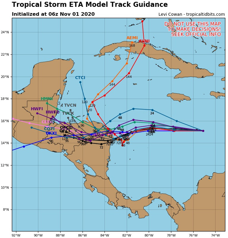
The 06z GFS might be onto something with its weak sheared solutions beyond Central America.
https://twitter.com/andyhazelton/status/1322884208361177090
Even the 00z Euro shows a sheared/hybrid system when it nears Florida.
https://twitter.com/hurricanemanwx/status/1322873160316891136
https://twitter.com/andyhazelton/status/1322884208361177090
Even the 00z Euro shows a sheared/hybrid system when it nears Florida.
https://twitter.com/hurricanemanwx/status/1322873160316891136
0 likes
Re: ATL: ETA - Models
SFLcane wrote:here comes the turn tcvn now north the nhc.
https://i.postimg.cc/Y9dMFL7T/C0-BAE7-BE-A647-467-A-8-C7-F-4-DD8819-D64-E5.jpg
And I would expect the TVCN to continue with trend more north and east in the 72-120 hr range as the Euro continues little by little get closer to the GFS's & HWRF solutions.
4 likes

-
Shell Mound
- Category 5
- Posts: 2432
- Age: 33
- Joined: Thu Sep 07, 2017 3:39 pm
- Location: St. Petersburg, FL → Scandinavia
Re: ATL: ETA - Models
Clearly, the strongest members in the short term also show the earliest slowdown, stall, and/or northward turn. Short-term intensity is crucial as well.
0 likes
CVW / MiamiensisWx / Shell Mound
The posts in this forum are NOT official forecasts and should not be used as such. They are just the opinion of the poster and may or may not be backed by sound meteorological data. They are NOT endorsed by any professional institution or STORM2K. For official information, please refer to products from the NHC and NWS.
Re: ATL: ETA - Models
06z Euro continues its trend in slowing Eta down before making landfall in Nica, now shows landfall at 6 PM CST on Tuesday.


2 likes

Re: ATL: ETA - Models
Shell Mound wrote:
https://pbs.twimg.com/media/ElvW8DoWMAYSNcn?format=jpg&name=large
Clearly, the strongest members in the short term also show the earliest slowdown, stall, and/or northward turn. Short-term intensity is crucial as well.
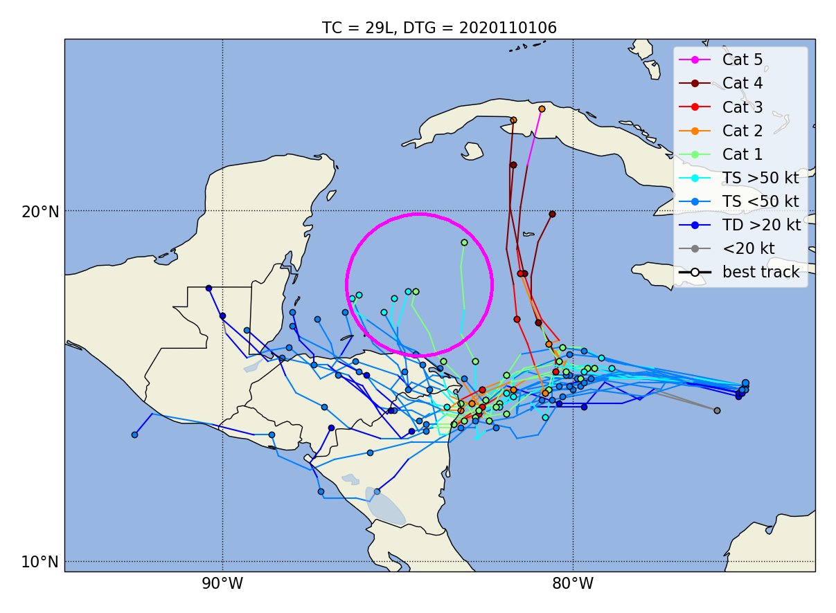
So basically a Cat 1 before 80W equals uh oh
0 likes
-
Blown Away

- S2K Supporter
- Posts: 10253
- Joined: Wed May 26, 2004 6:17 am
Re: ATL: ETA - Models
12z TVCN now offshore moving NNE @120 hours. TVCN continues to show a sharper N turn and now appears to be missing the big mountains inland and moving over flatter CA.
Last edited by Blown Away on Sun Nov 01, 2020 9:11 am, edited 1 time in total.
2 likes
Hurricane Eye Experience: David 79, Irene 99, Frances 04, Jeanne 04, Wilma 05… Hurricane Brush Experience: Andrew 92, Erin 95, Floyd 99, Matthew 16, Irma 17, Ian 22, Nicole 22…
Re: ATL: ETA - Models
TheStormExpert wrote::uarrow: 06z Euro is SW of the 00z run too.
The 0z Euro had landfall just about the same spot, just a few more miles north, but 12 hrs faster with landfall than the 06z run. The 0z Euro also had it progressing more westward, the 06 ends further east at 90 hrs than the 0z run.


0 likes
-
SFLcane

- S2K Supporter
- Posts: 10281
- Age: 48
- Joined: Sat Jun 05, 2010 1:44 pm
- Location: Lake Worth Florida
Re: ATL: ETA - Models
Blown Away wrote:12z TVCN now offshore moving NNE @120 hours. TVCN continues to show a sharper N turn and now appears to be missing the big islands inland and moving over flatter CA.
Yikes! Sharp hook now
0 likes

-
Blown Away
- S2K Supporter
- Posts: 10253
- Joined: Wed May 26, 2004 6:17 am
Re: ATL: ETA - Models
SFLcane wrote:Blown Away wrote:12z TVCN now offshore moving NNE @120 hours. TVCN continues to show a sharper N turn and now appears to be missing the big mountains inland and moving over flatter CA.
Yikes! Sharp hook now
2 likes
Hurricane Eye Experience: David 79, Irene 99, Frances 04, Jeanne 04, Wilma 05… Hurricane Brush Experience: Andrew 92, Erin 95, Floyd 99, Matthew 16, Irma 17, Ian 22, Nicole 22…
Who is online
Users browsing this forum: No registered users and 21 guests