ATL: ETA - Models
Moderator: S2k Moderators

Re: ATL: ETA - Models
I'm very concerned about the recent developments, especially since the stronger members seem to have a stronger and earlier hook and I think Eta is already stronger than the models currently intialize it at. It could be good (or at least better) news for CA, but could in the end be very very bad news for Cuba and/or the US. That recon mission can't come soon enough.
2 likes

Re: ATL: ETA - Models
A closer look at the 12z TVCN 7 day range forecast.
One model I will be looking at really close is the CTCX, it did really well with Sally when the steerings collapsed, similar to what will Eta's set up.

One model I will be looking at really close is the CTCX, it did really well with Sally when the steerings collapsed, similar to what will Eta's set up.
5 likes
-
Hypercane_Kyle

- Category 5

- Posts: 3465
- Joined: Sat Mar 07, 2015 7:58 pm
- Location: Cape Canaveral, FL
Re: ATL: ETA - Models
aspen wrote:HWRF is weaker (~960 mbar instead of 940s), but it still shows a pinhole eye, and it tries to stall Eta just off of the coast or barely on it.
Landfall intensity is 948mb.
0 likes
My posts are my own personal opinion, defer to the National Hurricane Center (NHC) and other NOAA products for decision making during hurricane season.
Re: ATL: ETA - Models
The NHC mentions nothing about the track beyond CA - my guess they know that there is not enough data in the models at this point to make an accurate forecast.
https://www.nhc.noaa.gov/text/refresh/M ... 0848.shtml
https://www.nhc.noaa.gov/text/refresh/M ... 0848.shtml
0 likes
-
AutoPenalti
- Category 5
- Posts: 4091
- Age: 29
- Joined: Mon Aug 17, 2015 4:16 pm
- Location: Ft. Lauderdale, Florida
Re: ATL: ETA - Models
It’s really become a game of inches at this point.
0 likes
The posts in this forum are NOT official forecasts and should not be used as such. They are just the opinion of the poster and may or may not be backed by sound meteorological data. They are NOT endorsed by any professional institution or STORM2K. For official information, please refer to products from the NHC and NWS.
Model Runs Cheat Sheet:
GFS (5:30 AM/PM, 11:30 AM/PM)
HWRF, GFDL, UKMET, NAVGEM (6:30-8:00 AM/PM, 12:30-2:00 AM/PM)
ECMWF (1:45 AM/PM)
TCVN is a weighted averaged
-
Blown Away

- S2K Supporter

- Posts: 10253
- Joined: Wed May 26, 2004 6:17 am
Re: ATL: ETA - Models
It seems the sharper the turn over CA allows Eta possibly to make it as far NE to just SSE of SFL before beginning a NW movement. Would likely be the first track of its kind, but it seems their have been many firsts over past few years.
0 likes
Hurricane Eye Experience: David 79, Irene 99, Frances 04, Jeanne 04, Wilma 05… Hurricane Brush Experience: Andrew 92, Erin 95, Floyd 99, Matthew 16, Irma 17, Ian 22, Nicole 22…
-
Blown Away
- S2K Supporter
- Posts: 10253
- Joined: Wed May 26, 2004 6:17 am
Re: ATL: ETA - Models
06z HWRF @1 degree N of 00z with a wrecked Eta moving off N Honduras coast @99 hrs...
06z HMON now only spends 24 hours (@72-96 hrs) over CA before moving off N coast of Honduras. Pretty big N & E shifts occurring.
06z HMON now only spends 24 hours (@72-96 hrs) over CA before moving off N coast of Honduras. Pretty big N & E shifts occurring.
Last edited by Blown Away on Sun Nov 01, 2020 10:17 am, edited 1 time in total.
0 likes
Hurricane Eye Experience: David 79, Irene 99, Frances 04, Jeanne 04, Wilma 05… Hurricane Brush Experience: Andrew 92, Erin 95, Floyd 99, Matthew 16, Irma 17, Ian 22, Nicole 22…
-
SFLcane

- S2K Supporter
- Posts: 10281
- Age: 48
- Joined: Sat Jun 05, 2010 1:44 pm
- Location: Lake Worth Florida
Re: ATL: ETA - Models
Blown Away wrote:It seems the sharper the turn over CA allows Eta possibly to make it as far NE to just SSE of SFL before beginning a NW movement. Would likely be the first track of its kind, but it seems their have been many firsts over past few years.
Hmm not sure all these models might have to be thrown out with now a relocation of the center to the south. Our luck continues potentially for SFL but could be a flooding disaster down in CA.
Last edited by SFLcane on Sun Nov 01, 2020 10:20 am, edited 1 time in total.
0 likes
-
AutoPenalti
- Category 5
- Posts: 4091
- Age: 29
- Joined: Mon Aug 17, 2015 4:16 pm
- Location: Ft. Lauderdale, Florida
Re: ATL: ETA - Models
SFLcane wrote:Blown Away wrote:It seems the sharper the turn over CA allows Eta possibly to make it as far NE to just SSE of SFL before beginning a NW movement. Would likely be the first track of its kind, but it seems their have been many firsts over past few years.
Hmm not sure all these models might have to be thrown out with now a relocation of the center to the south. We shall see
Yup, maybe a change in the track as it gets closer to CA.
0 likes
The posts in this forum are NOT official forecasts and should not be used as such. They are just the opinion of the poster and may or may not be backed by sound meteorological data. They are NOT endorsed by any professional institution or STORM2K. For official information, please refer to products from the NHC and NWS.
Model Runs Cheat Sheet:
GFS (5:30 AM/PM, 11:30 AM/PM)
HWRF, GFDL, UKMET, NAVGEM (6:30-8:00 AM/PM, 12:30-2:00 AM/PM)
ECMWF (1:45 AM/PM)
TCVN is a weighted averaged

Re: ATL: ETA - Models
Looks like the NHC is sticking to burying deep in CA which is horrible for them and better for us.
0 likes

Re: ATL: ETA - Models
Global models seem to have come to a consensus on a landfall at 06z Tuesday. However, the HWRF and HMON are a little slower, with the former showing a landfall Tuesday afternoon and the latter not having landfall until early Wednesday.
0 likes
Irene '11 Sandy '12 Hermine '16 5/15/2018 Derecho Fay '20 Isaias '20 Elsa '21 Henri '21 Ida '21
I am only a meteorology enthusiast who knows a decent amount about tropical cyclones. Look to the professional mets, the NHC, or your local weather office for the best information.
I am only a meteorology enthusiast who knows a decent amount about tropical cyclones. Look to the professional mets, the NHC, or your local weather office for the best information.
-
Spacecoast

- Category 2

- Posts: 773
- Joined: Thu Aug 31, 2017 2:03 pm
Re: ATL: ETA - Models
A better picture seems to be forming with a regenerated system heading towards Cuba, then hooking west.


0 likes
-
Shell Mound
- Category 5
- Posts: 2432
- Age: 33
- Joined: Thu Sep 07, 2017 3:39 pm
- Location: St. Petersburg, FL → Scandinavia
Re: ATL: ETA - Models
AutoPenalti wrote:SFLcane wrote:Blown Away wrote:It seems the sharper the turn over CA allows Eta possibly to make it as far NE to just SSE of SFL before beginning a NW movement. Would likely be the first track of its kind, but it seems their have been many firsts over past few years.
Hmm not sure all these models might have to be thrown out with now a relocation of the center to the south. We shall see
Yup, maybe a change in the track as it gets closer to CA.
The 15:00 UTC advisory package only made a slight southward adjustment based on the reformed centre. Already this is considerably more intense than most of the guidance indicated, so I wouldn’t necessarily postulate that a southward relocation implies a track farther inland over CA. I still think that models will eventually converge on a solution that shows only a brief landfall on CA and then a relatively steep incline to the north, back offshore. Currently the TVCN shows Eta hitting the edge of the mountains before turning, so the models that are closest to the TVCN show a much weaker Eta reemerging over the Gulf of Honduras. At this point I think the turn is likely to occur along/over the coast rather than well inland over the mountains. Expect future shifts to the east starting on day three.
Edit: the incoming 12Z GFS literally shows Eta stalling right over the northeastern coast of Nicaragua in two days. This hints that future runs may turn there.
2 likes
CVW / MiamiensisWx / Shell Mound
The posts in this forum are NOT official forecasts and should not be used as such. They are just the opinion of the poster and may or may not be backed by sound meteorological data. They are NOT endorsed by any professional institution or STORM2K. For official information, please refer to products from the NHC and NWS.
Re: ATL: ETA - Models
12z HWRF slower and stronger than 06z so far, 967 mbar at 21 hours (hurricane at 15 hours) and 80.2W instead of the 80.7W that 06z had at this time step.
0 likes
-
Shell Mound
- Category 5
- Posts: 2432
- Age: 33
- Joined: Thu Sep 07, 2017 3:39 pm
- Location: St. Petersburg, FL → Scandinavia
Re: ATL: ETA - Models
kevin wrote:12z HWRF slower and stronger than 06z so far, 967 mbar at 21 hours (hurricane at 15 hours) and 80.2W instead of the 80.7W that 06z had at this time step.
The run literally shows Eta undergoing rapid deepening and becoming a borderline major hurricane (~965 mb) in the next twenty-four hours, heading due W.
Edit #1: the run is much slower—half a degree—in a day and a half vs. 06Z. Eta is a powerful Category-3/-4 hurricane drifting south of due west by then.
Edit #2: it’s official, the run shows a loop starting offshore by day two! Eta actually drifts a bit to the south-southeast while deepening E of Cabo Gracias a Dios.
Edit #3: officially stalls as an intensifying pinhole-eyed Cat-4+ major hurricane while drifting northward, still E of Cabo Gracias a Dios, by hour forty-five.

It’s a full degree east of 06Z’s position by then!

Last edited by Shell Mound on Sun Nov 01, 2020 12:19 pm, edited 5 times in total.
0 likes
CVW / MiamiensisWx / Shell Mound
The posts in this forum are NOT official forecasts and should not be used as such. They are just the opinion of the poster and may or may not be backed by sound meteorological data. They are NOT endorsed by any professional institution or STORM2K. For official information, please refer to products from the NHC and NWS.
Re: ATL: ETA - Models
12Z UKMET: similar to NHC through landfall over Nicaragua though it never gets stronger than a low end cat 1 H per 994 mb pressure. Then it continues WSW through N Nicaragua all the way into the EPac, where it restrengthens some and then continues further WSW well offshore. Next it stalls and then comes NE into W El Salvador, where it dissipates Fri night:
MET OFFICE TROPICAL CYCLONE GUIDANCE FOR NORTH-EAST PACIFIC AND ATLANTIC
GLOBAL MODEL DATA TIME 1200UTC 01.11.2020
TROPICAL STORM ETA ANALYSED POSITION : 13.7N 76.8W
ATCF IDENTIFIER : AL292020
LEAD CENTRAL MAXIMUM WIND
VERIFYING TIME TIME POSITION PRESSURE (MB) SPEED (KNOTS)
-------------- ---- -------- ------------- -------------
1200UTC 01.11.2020 0 13.7N 76.8W 1008 26
0000UTC 02.11.2020 12 14.5N 79.5W 1006 26
1200UTC 02.11.2020 24 13.7N 81.8W 1003 27
0000UTC 03.11.2020 36 13.0N 82.5W 1000 29
1200UTC 03.11.2020 48 13.5N 83.2W 995 41
0000UTC 04.11.2020 60 13.3N 84.6W 994 31
1200UTC 04.11.2020 72 12.7N 86.2W 1000 35
0000UTC 05.11.2020 84 12.8N 88.2W 993 44
1200UTC 05.11.2020 96 12.6N 89.7W 997 43
0000UTC 06.11.2020 108 12.0N 90.8W 997 36
1200UTC 06.11.2020 120 12.3N 90.7W 997 36
0000UTC 07.11.2020 132 13.7N 89.7W 1001 36
1200UTC 07.11.2020 144 CEASED TRACKING
Last edited by LarryWx on Sun Nov 01, 2020 12:03 pm, edited 1 time in total.
0 likes
Personal Forecast Disclaimer:
The posts in this forum are NOT official forecasts and should not be used as such. They are just the opinion of the poster and may or may not be backed by sound meteorological data. They are NOT endorsed by any professional institution or storm2k.org. For official information, please refer to the NHC and NWS products.
The posts in this forum are NOT official forecasts and should not be used as such. They are just the opinion of the poster and may or may not be backed by sound meteorological data. They are NOT endorsed by any professional institution or storm2k.org. For official information, please refer to the NHC and NWS products.
Re: ATL: ETA - Models
12z HWRF has a scary looking pinhole eye system by this time tomorrow.
2 likes
Irene '11 Sandy '12 Hermine '16 5/15/2018 Derecho Fay '20 Isaias '20 Elsa '21 Henri '21 Ida '21
I am only a meteorology enthusiast who knows a decent amount about tropical cyclones. Look to the professional mets, the NHC, or your local weather office for the best information.
I am only a meteorology enthusiast who knows a decent amount about tropical cyclones. Look to the professional mets, the NHC, or your local weather office for the best information.
-
CourierPR

- Category 5
- Posts: 1336
- Age: 71
- Joined: Tue Aug 31, 2004 7:53 pm
- Location: Pompano Beach, Florida
Re: ATL: ETA - Models
SFLcane wrote:Gfs continues to insist SFL may see impacts from ETA.
This was brought up by the weekend met. on NBC6 Miami this morning and they are always very cautious about causing panic.
3 likes
-
gatorcane

- S2K Supporter
- Posts: 23704
- Age: 47
- Joined: Sun Mar 13, 2005 3:54 pm
- Location: Boca Raton, FL
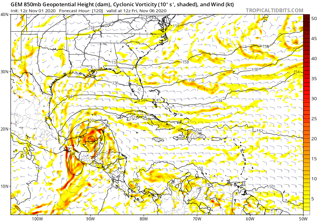
Re: ATL: ETA - Models
CMC heading to, you guessed it, LA albeit fizzles before it landfalls:
0 likes
Who is online
Users browsing this forum: No registered users and 103 guests