ATL: ETA - Models
Moderator: S2k Moderators
Re: ATL: ETA - Models
12Z CMC: never goes more than barely offshore into Gulf of Honduras and then goes into Belize followed by MX/up the Yucatan Pen. Then it emerges into the GOM followed by a landfall in SE LA a week from Mon night although it is already weakening then.
Last edited by LarryWx on Sun Nov 01, 2020 12:18 pm, edited 1 time in total.
2 likes
Personal Forecast Disclaimer:
The posts in this forum are NOT official forecasts and should not be used as such. They are just the opinion of the poster and may or may not be backed by sound meteorological data. They are NOT endorsed by any professional institution or storm2k.org. For official information, please refer to the NHC and NWS products.
The posts in this forum are NOT official forecasts and should not be used as such. They are just the opinion of the poster and may or may not be backed by sound meteorological data. They are NOT endorsed by any professional institution or storm2k.org. For official information, please refer to the NHC and NWS products.

Re: ATL: ETA - Models
Hmm...the HWRF has a quick EWRC (Wilma-like pinhole becomes a few miles larger) and has Eta start its stall/SW turn well before reaching CA. This run might go nuts with intensity if it doesn’t have a landfall.
0 likes
Irene '11 Sandy '12 Hermine '16 5/15/2018 Derecho Fay '20 Isaias '20 Elsa '21 Henri '21 Ida '21
I am only a meteorology enthusiast who knows a decent amount about tropical cyclones. Look to the professional mets, the NHC, or your local weather office for the best information.
I am only a meteorology enthusiast who knows a decent amount about tropical cyclones. Look to the professional mets, the NHC, or your local weather office for the best information.
-
gatorcane

- S2K Supporter

- Posts: 23704
- Age: 47
- Joined: Sun Mar 13, 2005 3:54 pm
- Location: Boca Raton, FL
Re: ATL: ETA - Models
LarryWx wrote:12Z CMC: never goes more than barely offshore into Gulf of Honduras and then goes into Belize followed by MX/up the Yucatan Pen. Then it emerges into the GOM followed by a landfall in SE LA a week from Mon night although it is already weakening then.
our posts crossed, posting image again on new page.
2 likes
-
SconnieCane
- Category 5

- Posts: 1013
- Joined: Thu Aug 02, 2018 5:29 pm
- Location: Madison, WI
Re: ATL: ETA - Models
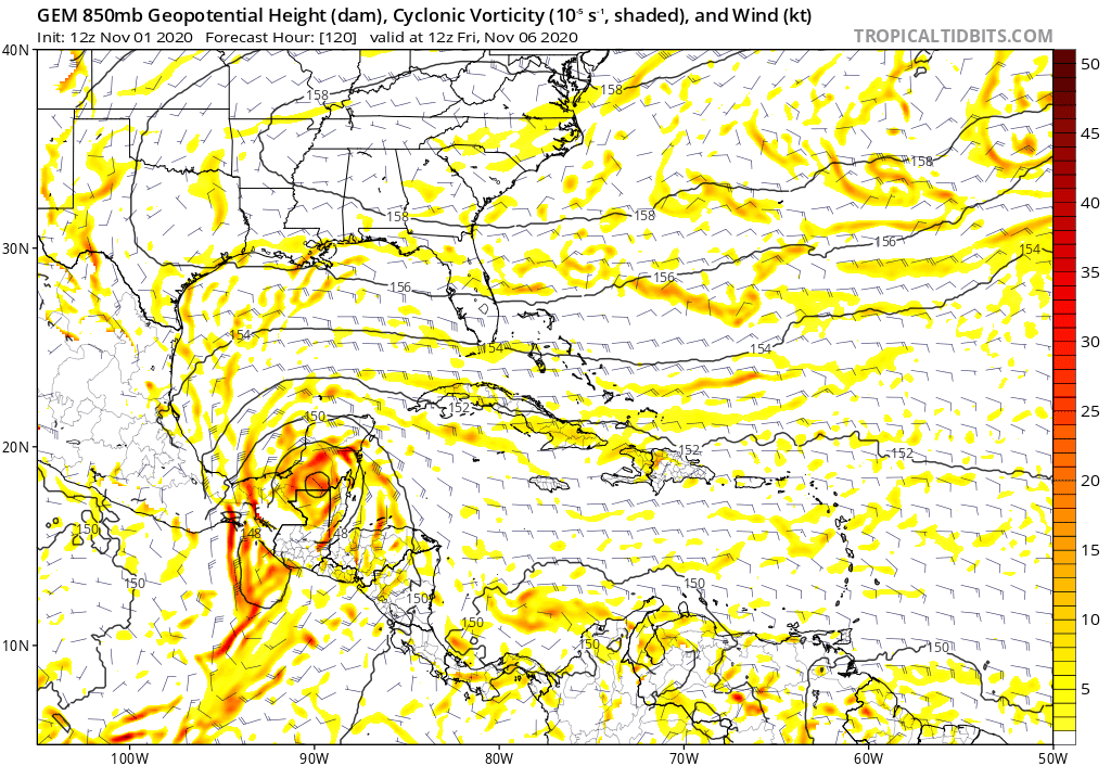
gatorcane wrote:LarryWx wrote:12Z CMC: never goes more than barely offshore into Gulf of Honduras and then goes into Belize followed by MX/up the Yucatan Pen. Then it emerges into the GOM followed by a landfall in SE LA a week from Mon night although it is already weakening then.
our posts crossed, posting image again on new page.
https://i.postimg.cc/d3sPFKpp/gem-z850-vort-watl-fh120-240.gif
(Facepalms). Of course some model would find a way to take this into LA.
2 likes
-
Shell Mound
- Category 5
- Posts: 2432
- Age: 33
- Joined: Thu Sep 07, 2017 3:39 pm
- Location: St. Petersburg, FL → Scandinavia
Re: ATL: ETA - Models
aspen wrote:Hmm...the HWRF has a quick EWRC (Wilma-like pinhole becomes a few miles larger) and has Eta start its stall/SW turn well before reaching CA. This run might go nuts with intensity if it doesn’t have a landfall.
The run already is “going nuts” with Eta’s intensity so far. Also, take a look at this!


Last edited by Shell Mound on Sun Nov 01, 2020 12:22 pm, edited 1 time in total.
0 likes
CVW / MiamiensisWx / Shell Mound
The posts in this forum are NOT official forecasts and should not be used as such. They are just the opinion of the poster and may or may not be backed by sound meteorological data. They are NOT endorsed by any professional institution or STORM2K. For official information, please refer to products from the NHC and NWS.
Re: ATL: ETA - Models
12Z HMON furthest S of any recent run at landfall. 12Z HWRF actually moved E slightly well offshore CA from 82.5W to 82.3W and is by far furthest E at that point of any recent run. This is an extreme outlier vs any other model to move back east then.
It then starts moving N.
It then starts moving N.
Last edited by LarryWx on Sun Nov 01, 2020 12:25 pm, edited 3 times in total.
0 likes
Personal Forecast Disclaimer:
The posts in this forum are NOT official forecasts and should not be used as such. They are just the opinion of the poster and may or may not be backed by sound meteorological data. They are NOT endorsed by any professional institution or storm2k.org. For official information, please refer to the NHC and NWS products.
The posts in this forum are NOT official forecasts and should not be used as such. They are just the opinion of the poster and may or may not be backed by sound meteorological data. They are NOT endorsed by any professional institution or storm2k.org. For official information, please refer to the NHC and NWS products.
-
gatorcane
- S2K Supporter
- Posts: 23704
- Age: 47
- Joined: Sun Mar 13, 2005 3:54 pm
- Location: Boca Raton, FL
Re: ATL: ETA - Models
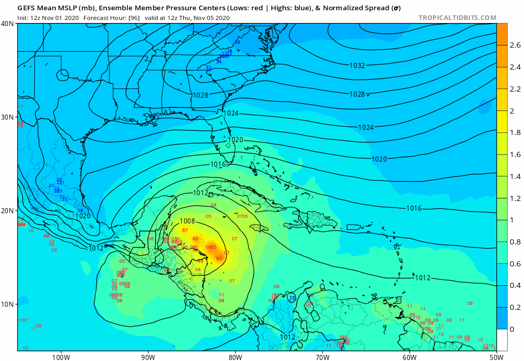
GFS ensembles look weaker to me. Also that is quite a turn to the west near Cuba. The Euro showed it. Wonder if It never makes it out of the Caribbean or ends up well west of Florida?
Last edited by gatorcane on Sun Nov 01, 2020 12:24 pm, edited 2 times in total.
0 likes
-
HurricaneBelle

- S2K Supporter
- Posts: 1205
- Joined: Sun Aug 27, 2006 6:12 pm
- Location: Clearwater, FL
Re: ATL: ETA - Models
12Z GFS regenerates in the NW Caribbean, sends it ENE as a strong TS to the eastern tip of Cuba, where it turns NW into the Keys and SFL and then up the FL West Coast where it meanders around Tampa for a while before weakening and moving NW into the western FL panhandle where it's absorbed by a front. Meanwhile, it develops the next system (Theta?) near the Greater Antilles and moves it NE into the open Atlantic intensifying east of Bermuda.
0 likes

Re: ATL: ETA - Models
boca wrote:Looks like the NHC is sticking to burying deep in CA which is horrible for them and better for us.
NHC recognizes the track uncertainty but its beyond 5 days so they're being prudent and waiting on more model consensus. From the 11 am disc:
There is increased uncertainty in the track forecast post-landfall, with a
range of plausible outcomes. While much of the guidance suggests Eta
will spin down and weaken over Central America or possibly cross
into the eastern Pacific, some model solutions indicate the
potential for Eta or its remnants to re-emerge over the northwestern
Caribbean Sea at or beyond day 5. For now, the official NHC forecast
remains close to the previous one and the corrected consensus aid
HCCA, which keeps the cyclone inland over Central America through
day 5.
3 likes
Re: ATL: ETA - Models
Shell Mound wrote:aspen wrote:Hmm...the HWRF has a quick EWRC (Wilma-like pinhole becomes a few miles larger) and has Eta start its stall/SW turn well before reaching CA. This run might go nuts with intensity if it doesn’t have a landfall.
The run already is “going nuts” with Eta’s intensity so far. Also, take a look at this!North turn starts over water by day two!
The HWRF keeps Eta over water for so long, it starts an EWRC on Tuesday. I wonder how right the HWRF will be about an EWRC because it did predict one for Goni, but it overestimated the potential for the core to be disrupted.
2 likes
Irene '11 Sandy '12 Hermine '16 5/15/2018 Derecho Fay '20 Isaias '20 Elsa '21 Henri '21 Ida '21
I am only a meteorology enthusiast who knows a decent amount about tropical cyclones. Look to the professional mets, the NHC, or your local weather office for the best information.
I am only a meteorology enthusiast who knows a decent amount about tropical cyclones. Look to the professional mets, the NHC, or your local weather office for the best information.
Re: ATL: ETA - Models
12Z HWRF may never come ashore CA, an extreme outlier. Throw this run out as nonsense or not?
0 likes
Personal Forecast Disclaimer:
The posts in this forum are NOT official forecasts and should not be used as such. They are just the opinion of the poster and may or may not be backed by sound meteorological data. They are NOT endorsed by any professional institution or storm2k.org. For official information, please refer to the NHC and NWS products.
The posts in this forum are NOT official forecasts and should not be used as such. They are just the opinion of the poster and may or may not be backed by sound meteorological data. They are NOT endorsed by any professional institution or storm2k.org. For official information, please refer to the NHC and NWS products.

Re: ATL: ETA - Models
The run still isn't finished, but if HWRF indeed doesn't landfall in CA that would be great news for CA but terrible news for Cuba and the US. If it does track north after this it will go over the place with the highest water potential in the WCar as a major.
0 likes
-
gatorcane
- S2K Supporter
- Posts: 23704
- Age: 47
- Joined: Sun Mar 13, 2005 3:54 pm
- Location: Boca Raton, FL
Re: ATL: ETA - Models
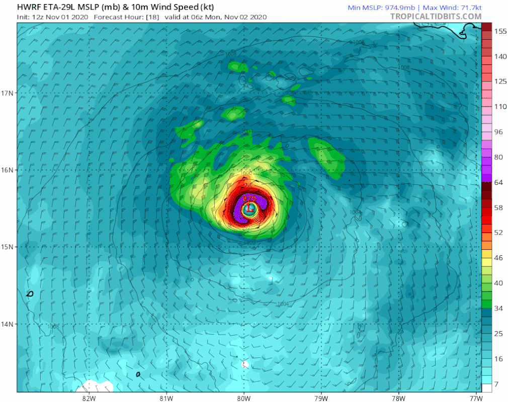
Shell Mound wrote:aspen wrote:Hmm...the HWRF has a quick EWRC (Wilma-like pinhole becomes a few miles larger) and has Eta start its stall/SW turn well before reaching CA. This run might go nuts with intensity if it doesn’t have a landfall.
The run already is “going nuts” with Eta’s intensity so far. Also, take a look at this!
Looks like it does a full small loop and heading west again at 51 hours towards CA.
Last edited by gatorcane on Sun Nov 01, 2020 12:31 pm, edited 1 time in total.
2 likes
Re: ATL: ETA - Models
gatorcane wrote:GFS ensembles look weaker to me. Also that is quite a turn to the west near Cuba. The Euro showed it. Wonder if It never makes it out of the Caribbean or ends up well west of Florida?
https://i.postimg.cc/8PfwCYG0/gfs-ememb-lowlocs-watl-fh96-204.gif
And eventually comes back east to Florida with the next front? Not something I want to see on Florida's west coast.
2 likes

Re: ATL: ETA - Models
LarryWx wrote:12Z HWRF may never come ashore CA, an extreme outlier. Throw this run out as nonsense or not?
Why? Many GFS ensemble members show that the stronger Eta becomes the less chance it could have to come ashore. The question should be will it become that strong?
3 likes
Re: ATL: ETA - Models
Even if the HWRF solution is an extreme one in terms of how far east it stalls, I think models today have shown that a CA landfall or at least a direct CA landfall is far from certain and that a long stall before a CA landfall or even a stall and then a turn north are definitely realistic options. Both of the latter cases could give Eta way more time to intensify and could make its impact, wherever it landfalls, significantly bigger.
3 likes
Re: ATL: ETA - Models
gatorcane wrote:Shell Mound wrote:aspen wrote:Hmm...the HWRF has a quick EWRC (Wilma-like pinhole becomes a few miles larger) and has Eta start its stall/SW turn well before reaching CA. This run might go nuts with intensity if it doesn’t have a landfall.
The run already is “going nuts” with Eta’s intensity so far. Also, take a look at this!
Looks like it does a full small loop and heading west again at 51 hours towards CA.
https://i.postimg.cc/zvxZcdzn/hwrf-mslp-wind-29-L-fh18-51.gif
You spoke too soon, general NW heading.
0 likes
Re: ATL: ETA - Models
HWRF has a loop offshore of CA and a successful EWRC that leads to even more intensification as Eta heads north. Great news for CA (they don’t get Mitch 2.0), probably bad news for Cuba (might be a strong system at landfall).
3 likes
Irene '11 Sandy '12 Hermine '16 5/15/2018 Derecho Fay '20 Isaias '20 Elsa '21 Henri '21 Ida '21
I am only a meteorology enthusiast who knows a decent amount about tropical cyclones. Look to the professional mets, the NHC, or your local weather office for the best information.
I am only a meteorology enthusiast who knows a decent amount about tropical cyclones. Look to the professional mets, the NHC, or your local weather office for the best information.
Re: ATL: ETA - Models
12Z HWRF not coming ashore CA and instead heads to Gulf of Honduras as a strengthening monster in 930s. Warning: sometimes the HWRF has super wonky runs that turn out to be totally wrong, especially when it is on its own. But OTOH, if this outlier is only due to it being stronger E of CA, maybe it shouldn’t be thrown out as NDG suggests.
2 likes
Personal Forecast Disclaimer:
The posts in this forum are NOT official forecasts and should not be used as such. They are just the opinion of the poster and may or may not be backed by sound meteorological data. They are NOT endorsed by any professional institution or storm2k.org. For official information, please refer to the NHC and NWS products.
The posts in this forum are NOT official forecasts and should not be used as such. They are just the opinion of the poster and may or may not be backed by sound meteorological data. They are NOT endorsed by any professional institution or storm2k.org. For official information, please refer to the NHC and NWS products.
-
gatorcane
- S2K Supporter
- Posts: 23704
- Age: 47
- Joined: Sun Mar 13, 2005 3:54 pm
- Location: Boca Raton, FL
Re: ATL: ETA - Models
NAVGEM into the EPAC for the first time and no longer shows a NW Carib system.
0 likes
Who is online
Users browsing this forum: No registered users and 62 guests