So uhhhh recon hasn’t updated in an hour again...
Unless that’s normal until they actually get close to the system for Air Force planes?
ATL: ETA - Post-Tropical - Discussion
Moderator: S2k Moderators
-
tolakram
- Admin

- Posts: 20186
- Age: 62
- Joined: Sun Aug 27, 2006 8:23 pm
- Location: Florence, KY (name is Mark)
Re: ATL: ETA - Tropical Storm - Discussion
ClarCari wrote:Laminar wrote:ClarCari wrote:So uhhhh recon hasn’t updated in an hour again...
Unless that’s normal until they actually get close to the system for Air Force planes?
I don't think that the 2nd flight into ETA is airborne yet.
It took off an hour ago.
Did you remember to correct for standard rather than daylight time?
0 likes
M a r k
- - - - -
Join us in chat: Storm2K Chatroom Invite. Android and IOS apps also available.
The posts in this forum are NOT official forecasts and should not be used as such. Posts are NOT endorsed by any professional institution or STORM2K.org. For official information and forecasts, please refer to NHC and NWS products.

Re: ATL: ETA - Tropical Storm - Discussion
Still on deck
371
URNT15 KNHC 020125
AF306 0229A ETA HDOB 02 20201102
011630 3024N 08855W 0243 ///// 0228 +175 +082 000000 000 /// /// 23
011700 3024N 08855W 0243 00005 0250 +175 +082 000000 000 /// /// 03
011730 3024N 08855W 0244 00005 0250 +175 +080 000000 000 /// /// 03
011800 3024N 08855W 0243 00004 0249 +175 +081 000000 000 /// /// 03
011830 3024N 08855W 0244 00006 0250 +175 +081 000000 000 /// /// 03
011900 3024N 08855W 0244 00005 0250 +175 +080 000000 000 /// /// 03
011930 3024N 08855W 0244 00006 0251 +175 +083 000000 000 /// /// 03
012000 3024N 08855W 0244 00004 0249 +175 +083 000000 000 /// /// 03
012030 3024N 08855W 0244 00001 0245 +175 +082 000000 000 /// /// 03
012100 3024N 08855W 0244 00002 0247 +176 +081 000000 000 /// /// 03
012130 3024N 08855W 0244 00004 0249 +178 +079 000000 000 /// /// 03
012200 3024N 08855W 0244 00004 0249 +177 +083 000000 000 /// /// 03
012230 3024N 08855W 0244 00004 0249 +178 +087 000000 000 /// /// 03
012300 3024N 08855W 0244 00002 0247 +180 +088 000000 000 /// /// 03
012330 3024N 08855W 0244 00004 0249 +180 +091 000000 000 /// /// 03
012400 3024N 08855W 0244 00006 0251 +177 +089 000000 000 /// /// 03
012430 3024N 08855W 0244 00004 0249 +180 +090 000000 000 /// /// 03
012500 3024N 08855W 0244 00002 0247 +180 +089 000000 000 /// /// 03
012530 3024N 08855W 0244 00002 0247 +179 +090 000000 000 /// /// 03
012600 3024N 08855W 0244 00001 0246 +178 +092 000000 000 /// /// 03
$$
2 likes
FAA ATP
Belize UAS Operator
Belize UAS Operator
Re: ATL: ETA - Tropical Storm - Discussion
tolakram wrote:ClarCari wrote:Laminar wrote:
I don't think that the 2nd flight into ETA is airborne yet.
It took off an hour ago.
Did you remember to correct for standard rather than daylight time?
I live in CDT and we are now 6 hours behind UTC after DST and I assume military time alines with that still. The plane left 7:30 CDT for it’s 0145z departure (7:45PM).
0 likes
-
Keldeo1997
- Category 2

- Posts: 688
- Joined: Fri Oct 11, 2019 11:35 pm
Re: ATL: ETA - Tropical Storm - Discussion

Looks like the convective bursts are about to go dancing. Larua also had this twin convective Burst dance and it exploded afterwards.
Last edited by Keldeo1997 on Sun Nov 01, 2020 9:53 pm, edited 2 times in total.
8 likes
-
Deshaunrob17
- Tropical Storm

- Posts: 211
- Joined: Tue Aug 18, 2020 7:49 am
Re: ATL: ETA - Tropical Storm - Discussion
I hope unnoticed shear hits Eta like it did with Delta... Any chance? I was convinced Delta would have been a Cat 5..
Anyways rainfall looks ugly either way
Anyways rainfall looks ugly either way
0 likes


Re: ATL: ETA - Tropical Storm - Discussion
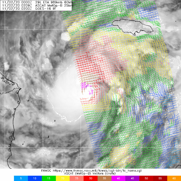
Major Hurricane now forecast (100kts)
...ETA CLOSE TO BECOMING A HURRICANE...
...LIFE-THREATENING STORM SURGE, DAMAGING WINDS, AND FLASH FLOODING
AND LANDSLIDES EXPECTED ACROSS PORTIONS OF CENTRAL AMERICA...
SUMMARY OF 1000 PM EST...0300 UTC...INFORMATION
-----------------------------------------------
LOCATION...14.9N 80.0W
ABOUT 215 MI...345 KM E OF CABO GRACIAS A DIOS ON NIC/HON BORDER
ABOUT 235 MI...380 KM ENE OF PUERTO CABEZAS NICARAGUA
MAXIMUM SUSTAINED WINDS...70 MPH...110 KM/H
PRESENT MOVEMENT...W OR 270 DEGREES AT 13 MPH...20 KM/H
MINIMUM CENTRAL PRESSURE...989 MB...29.21 INCHES
0 likes
-
Keldeo1997
- Category 2
- Posts: 688
- Joined: Fri Oct 11, 2019 11:35 pm
Re: ATL: ETA - Tropical Storm - Discussion
"formation of a pinhole mid-level eye noted in 01/2322Z 91GHz SSMI/S microwave imagery."
oh wow NHC said that they found a Pinhole.
oh wow NHC said that they found a Pinhole.
8 likes
-
ElectricStorm

- Category 5

- Posts: 5147
- Age: 25
- Joined: Tue Aug 13, 2019 11:23 pm
- Location: Norman, OK
Re: ATL: ETA - Tropical Storm - Discussion
Surprised NHC didn't upgrade to Cat 1 here. I guess they're just waiting for recon to confirm. Probably upgrade at the intermediate advisory. Finding a pinhole is extremely concerning... I hate to say it but if there's no shear around... Eta might be able to do what Delta almost did, become an absolute monster 
0 likes
B.S Meteorology, University of Oklahoma '25
Please refer to the NHC, NWS, or SPC for official information.
Please refer to the NHC, NWS, or SPC for official information.
-
Blown Away

- S2K Supporter

- Posts: 10253
- Joined: Wed May 26, 2004 6:17 am
Re: ATL: ETA - Tropical Storm - Discussion
Wow, what a catastrophe in the making. NHC keeps Eta over CA for @3 days. Wouldn’t be surprised if “Remnant Low” at the 5 day is in the future.
0 likes
Hurricane Eye Experience: David 79, Irene 99, Frances 04, Jeanne 04, Wilma 05… Hurricane Brush Experience: Andrew 92, Erin 95, Floyd 99, Matthew 16, Irma 17, Ian 22, Nicole 22…

Re: ATL: ETA - Tropical Storm - Discussion
Hypercane_Kyle wrote::uarrow: Forecast will be 100 knot peak at 10pm EST based on that.
How come this is the first I've seen a forecast intensity output before an advisory? I've seen that output stream before but never knew NHC forecast would be contained in the same.
0 likes
Re: ATL: ETA - Tropical Storm - Discussion
They hardly ever upgrade with marginal satellite support and an inbound airplane. Even if they think it may be higher, they always wait for the plane.
1 likes

Re: ATL: ETA - Tropical Storm - Discussion
Oh boy, the way the CDO is curling on GOES meso sector IR imagery...odds are there’s gonna be a pinhole eye in a few hours.
I’ll be asleep when recon arrives, but I’m going to estimate they find a hurricane of 75-85 kt and 970-980 mbar.
I’ll be asleep when recon arrives, but I’m going to estimate they find a hurricane of 75-85 kt and 970-980 mbar.
0 likes
Irene '11 Sandy '12 Hermine '16 5/15/2018 Derecho Fay '20 Isaias '20 Elsa '21 Henri '21 Ida '21
I am only a meteorology enthusiast who knows a decent amount about tropical cyclones. Look to the professional mets, the NHC, or your local weather office for the best information.
I am only a meteorology enthusiast who knows a decent amount about tropical cyclones. Look to the professional mets, the NHC, or your local weather office for the best information.
-
gatorcane

- S2K Supporter
- Posts: 23708
- Age: 48
- Joined: Sun Mar 13, 2005 3:54 pm
- Location: Boca Raton, FL
Re: ATL: ETA - Tropical Storm - Discussion
Blown Away wrote:Wow, what a catastrophe in the making. NHC keeps Eta over CA for @3 days. Wouldn’t be surprised if “Remnant Low” at the 5 day is in the future.
Possible but we may just get some broad low to form over the NW Caribbean from the CAG. Either way, what happened to all of the Florida posters this evening besides you (and I)?
1 likes
-
TheStormExpert
Re: ATL: ETA - Tropical Storm - Discussion
gatorcane wrote:Blown Away wrote:Wow, what a catastrophe in the making. NHC keeps Eta over CA for @3 days. Wouldn’t be surprised if “Remnant Low” at the 5 day is in the future.
Possible but we may just get some broad low to form over the NW Caribbean from the CAG. Either way, what happened to all of the Florida posters this evening besides you (and I)?
They’re probably won’t be anything left of Eta when it emerges in the Gulf of Honduras Friday evening. Maybe it’s best not to pay attention to those absurd GFS runs from a few days ago.
0 likes
Re: ATL: ETA - Tropical Storm - Discussion
NHC shows landfall very close to Puerto Cabezas, Nicaragua. Literaly the worst spot for a major hurricane landfall in this region.
It would be the strongest hurricane to make landfall in this region since Hurricane Felix, which made landfall as a Category 5.
It would be the strongest hurricane to make landfall in this region since Hurricane Felix, which made landfall as a Category 5.
0 likes
-
SouthFLTropics

- Category 5
- Posts: 4258
- Age: 50
- Joined: Thu Aug 14, 2003 8:04 am
- Location: Port St. Lucie, Florida
Re: ATL: ETA - Tropical Storm - Discussion
gatorcane wrote:Blown Away wrote:Wow, what a catastrophe in the making. NHC keeps Eta over CA for @3 days. Wouldn’t be surprised if “Remnant Low” at the 5 day is in the future.
Possible but we may just get some broad low to form over the NW Caribbean from the CAG. Either way, what happened to all of the Florida posters this evening besides you (and I)?
I'm here lurking and watching the model runs and satellite images. Out of respect for Central America, I think we can put the potential Florida impact discussions on the back burner for now. There will be plenty of time for that later this week and of course we will be watching the models each run to see what they do. More importantly, there is a major disaster about to unfold in Central America that has the potential for large losses of life.
9 likes
Fourth Generation Florida Native
Personal Storm History: David 79, Andrew 92, Erin 95, Floyd 99, Irene 99, Frances 04, Jeanne 04, Wilma 05, Matthew 16, Irma 17, Ian 22, Nicole 22, Milton 24
Personal Storm History: David 79, Andrew 92, Erin 95, Floyd 99, Irene 99, Frances 04, Jeanne 04, Wilma 05, Matthew 16, Irma 17, Ian 22, Nicole 22, Milton 24
-
CyclonicFury

- Category 5
- Posts: 2035
- Age: 27
- Joined: Sun Jul 02, 2017 12:32 pm
- Location: NC
- Contact:
Re: ATL: ETA - Tropical Storm - Discussion
TheStormExpert wrote:gatorcane wrote:Blown Away wrote:Wow, what a catastrophe in the making. NHC keeps Eta over CA for @3 days. Wouldn’t be surprised if “Remnant Low” at the 5 day is in the future.
Possible but we may just get some broad low to form over the NW Caribbean from the CAG. Either way, what happened to all of the Florida posters this evening besides you (and I)?
They’re probably won’t be anything left of Eta when it emerges in the Gulf of Honduras Friday evening. Maybe it’s best not to pay attention to those absurd GFS runs from a few days ago.
A new low could form within the broad cyclonic gyre as Levi indicated yesterday, and the Euro has been consistent on this for the last few runs.
2 likes
NCSU B.S. in Meteorology Class of 2021. Tropical weather blogger at http://www.cyclonicfury.com. My forecasts and thoughts are NOT official, for official forecasts please consult the National Hurricane Center.
Who is online
Users browsing this forum: No registered users and 84 guests