ATL: ETA - Models
Moderator: S2k Moderators
-
SouthFLTropics

- Category 5

- Posts: 4258
- Age: 50
- Joined: Thu Aug 14, 2003 8:04 am
- Location: Port St. Lucie, Florida
Re: ATL: ETA - Models
00z GFS already has Eta down to 979MB within the next 6 hours. Lowest it has shown at that time slot since inception. And that 979 is probably not low enough. I'm afraid the HWRF is going to verify here. Bad situation unfolding for the Mosquito Coast.
1 likes
Fourth Generation Florida Native
Personal Storm History: David 79, Andrew 92, Erin 95, Floyd 99, Irene 99, Frances 04, Jeanne 04, Wilma 05, Matthew 16, Irma 17, Ian 22, Nicole 22, Milton 24
Personal Storm History: David 79, Andrew 92, Erin 95, Floyd 99, Irene 99, Frances 04, Jeanne 04, Wilma 05, Matthew 16, Irma 17, Ian 22, Nicole 22, Milton 24
Re: ATL: ETA - Models
00z ICON goes with reformation in the Gulf of Honduras and then finishes the run heading towards Cuba as a strengthening storm
1 likes
-
SouthFLTropics
- Category 5
- Posts: 4258
- Age: 50
- Joined: Thu Aug 14, 2003 8:04 am
- Location: Port St. Lucie, Florida
Re: ATL: ETA - Models
ICON pulling out all the stops for 2020 with the rare Georgia coast hit on November 9th.
1 likes
Fourth Generation Florida Native
Personal Storm History: David 79, Andrew 92, Erin 95, Floyd 99, Irene 99, Frances 04, Jeanne 04, Wilma 05, Matthew 16, Irma 17, Ian 22, Nicole 22, Milton 24
Personal Storm History: David 79, Andrew 92, Erin 95, Floyd 99, Irene 99, Frances 04, Jeanne 04, Wilma 05, Matthew 16, Irma 17, Ian 22, Nicole 22, Milton 24
-
SFLcane

- S2K Supporter

- Posts: 10281
- Age: 48
- Joined: Sat Jun 05, 2010 1:44 pm
- Location: Lake Worth Florida
Re: ATL: ETA - Models
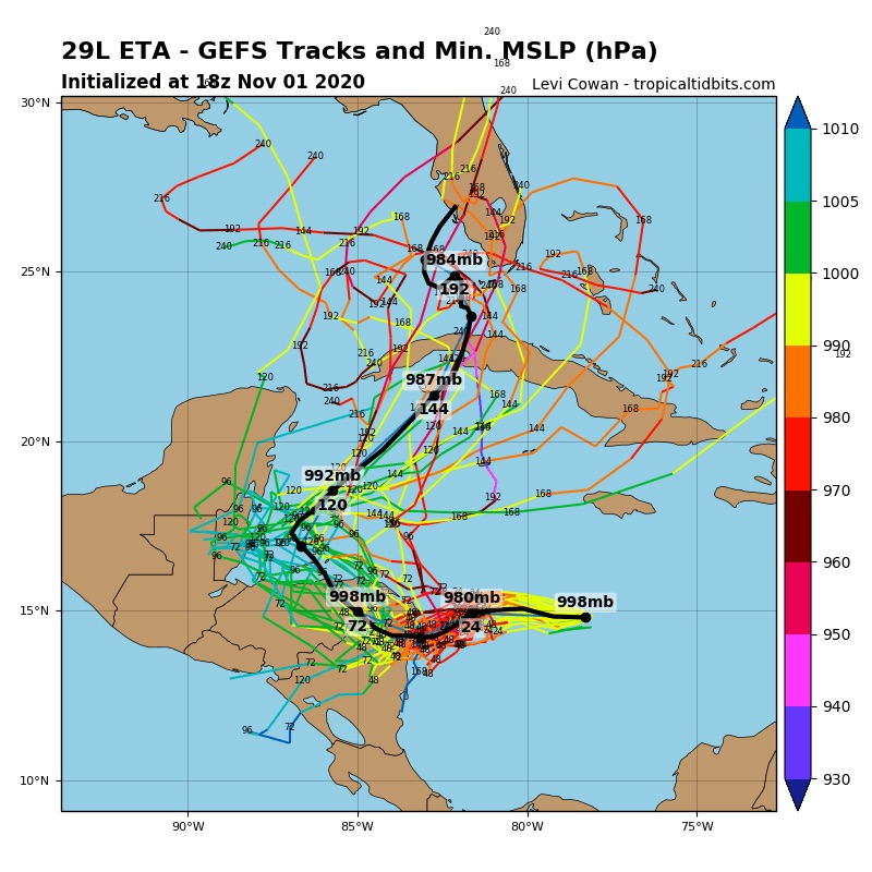
I find it amusing how some completely disregard the much improved GEFS ensembles.
3 likes
-
GeneratorPower

- S2K Supporter
- Posts: 1648
- Age: 46
- Joined: Sun Dec 18, 2005 11:48 pm
- Location: Huntsville, AL
Re: ATL: ETA - Models
SFLcane wrote:I find it amusing how some completely disregard the much improved GEFS ensembles.
https://i.postimg.cc/SxKcpt7c/928-CD158-8-AC7-4338-BAF1-60661-FD596-F4.jpg
Wow. That’s amazing. I didn’t know it was that different. Thanks for posting.
0 likes
-
TheStormExpert
Re: ATL: ETA - Models
SFLcane wrote:I find it amusing how some completely disregard the much improved GEFS ensembles.
https://i.postimg.cc/SxKcpt7c/928-CD158-8-AC7-4338-BAF1-60661-FD596-F4.jpg
Looks like a four year old drew on that map!
1 likes
-
Keldeo1997
- Category 2

- Posts: 688
- Joined: Fri Oct 11, 2019 11:35 pm
Re: ATL: ETA - Models

HWRF with recon data still bombing out. Only 3mbs weaker then last run
0 likes
-
SouthFLTropics
- Category 5
- Posts: 4258
- Age: 50
- Joined: Thu Aug 14, 2003 8:04 am
- Location: Port St. Lucie, Florida
Re: ATL: ETA - Models
18z vs 00z HMON... 00z faster by a good bit.

0 likes
Fourth Generation Florida Native
Personal Storm History: David 79, Andrew 92, Erin 95, Floyd 99, Irene 99, Frances 04, Jeanne 04, Wilma 05, Matthew 16, Irma 17, Ian 22, Nicole 22, Milton 24
Personal Storm History: David 79, Andrew 92, Erin 95, Floyd 99, Irene 99, Frances 04, Jeanne 04, Wilma 05, Matthew 16, Irma 17, Ian 22, Nicole 22, Milton 24
-
ElectricStorm

- Category 5
- Posts: 5124
- Age: 24
- Joined: Tue Aug 13, 2019 11:23 pm
- Location: Norman, OK
Re: ATL: ETA - Models
HWRF much stronger than HMON... strong Cat 4 coming in  Loops back SE without landfall so far at hour 39
0 likes
B.S Meteorology, University of Oklahoma '25
Please refer to the NHC, NWS, or SPC for official information.
Please refer to the NHC, NWS, or SPC for official information.
-
Spacecoast

- Category 2
- Posts: 773
- Joined: Thu Aug 31, 2017 2:03 pm
Re: ATL: ETA - Models
HWRF drops down to 14.5N prior to landfall,much further south than previous runs...
looks like a stall.
EDIT: A loop

looks like a stall.
EDIT: A loop
Last edited by Spacecoast on Mon Nov 02, 2020 12:29 am, edited 2 times in total.
0 likes


-
Deshaunrob17
- Tropical Storm

- Posts: 211
- Joined: Tue Aug 18, 2020 7:49 am
Re: ATL: ETA - Models
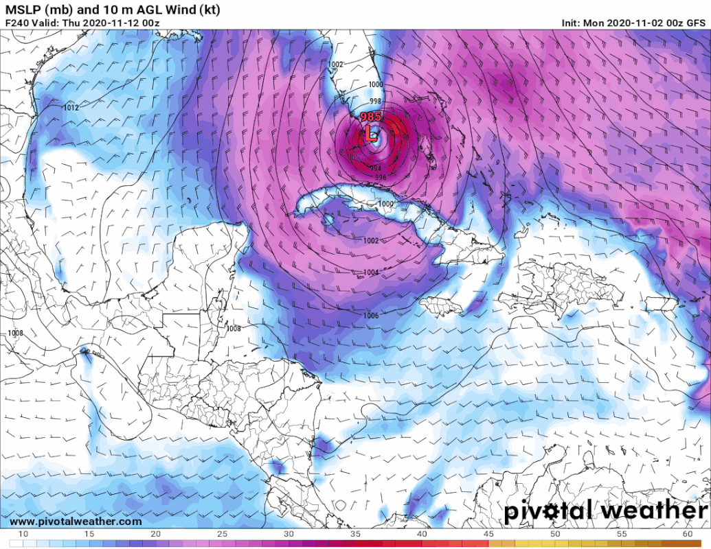
Spacecoast wrote:HWRF drops down to 14.5N prior to landfall,much further south than previous runs...
looks like a stall
https://i.ibb.co/6tf4Gx4/Capture111k.jpg
If you look at satellite, the model has Eta with Matthew-like appearance.. Weird and large looking hurricane with a large eastern blob attached to it
0 likes
-
ElectricStorm
- Category 5
- Posts: 5124
- Age: 24
- Joined: Tue Aug 13, 2019 11:23 pm
- Location: Norman, OK
Re: ATL: ETA - Models
Finally landfalls as a Cat 4 at hour 57. A catastrophe if that were to verify
0 likes
B.S Meteorology, University of Oklahoma '25
Please refer to the NHC, NWS, or SPC for official information.
Please refer to the NHC, NWS, or SPC for official information.
-
Spacecoast
- Category 2
- Posts: 773
- Joined: Thu Aug 31, 2017 2:03 pm
Re: ATL: ETA - Models
Deshaunrob17 wrote:Spacecoast wrote:HWRF drops down to 14.5N prior to landfall,much further south than previous runs...
looks like a stall
https://i.ibb.co/6tf4Gx4/Capture111k.jpg
If you look at satellite, the model has Eta with Matthew-like appearance.. Weird and large looking hurricane with a large eastern blob attached to it
Weather Dude wrote:Finally landfalls as a Cat 4 at hour 57. A catastrophe if that were to verify
Yes, I see the eastern convection. It was there on 18z runs as well.
HWRF & HMON have been consistent with powerful landfall near Laguna de Caratasca. A Cat 3/4 will probably verify, unfortunately.
0 likes
Re: ATL: ETA - Models
0Z Euro: a little bit further NE than most prior runs when in Nicaragua.
0 likes
Personal Forecast Disclaimer:
The posts in this forum are NOT official forecasts and should not be used as such. They are just the opinion of the poster and may or may not be backed by sound meteorological data. They are NOT endorsed by any professional institution or storm2k.org. For official information, please refer to the NHC and NWS products.
The posts in this forum are NOT official forecasts and should not be used as such. They are just the opinion of the poster and may or may not be backed by sound meteorological data. They are NOT endorsed by any professional institution or storm2k.org. For official information, please refer to the NHC and NWS products.
Re: ATL: ETA - Models
0Z Euro: coming out from Gulf of Honduras quite a bit stronger than the 12Z had.
0 likes
Personal Forecast Disclaimer:
The posts in this forum are NOT official forecasts and should not be used as such. They are just the opinion of the poster and may or may not be backed by sound meteorological data. They are NOT endorsed by any professional institution or storm2k.org. For official information, please refer to the NHC and NWS products.
The posts in this forum are NOT official forecasts and should not be used as such. They are just the opinion of the poster and may or may not be backed by sound meteorological data. They are NOT endorsed by any professional institution or storm2k.org. For official information, please refer to the NHC and NWS products.
-
SouthFLTropics
- Category 5
- Posts: 4258
- Age: 50
- Joined: Thu Aug 14, 2003 8:04 am
- Location: Port St. Lucie, Florida
ATL: ETA - Models
EURO... WHAT ARE YOU DOING??? Leave those people in Central America alone!!!
EDIT: Whew, for a minute there I thought the Euro was going to loop around and take another swipe at Honduras and Nicaragua.
Sent from my iPhone using Tapatalk
EDIT: Whew, for a minute there I thought the Euro was going to loop around and take another swipe at Honduras and Nicaragua.
Sent from my iPhone using Tapatalk
0 likes
Fourth Generation Florida Native
Personal Storm History: David 79, Andrew 92, Erin 95, Floyd 99, Irene 99, Frances 04, Jeanne 04, Wilma 05, Matthew 16, Irma 17, Ian 22, Nicole 22, Milton 24
Personal Storm History: David 79, Andrew 92, Erin 95, Floyd 99, Irene 99, Frances 04, Jeanne 04, Wilma 05, Matthew 16, Irma 17, Ian 22, Nicole 22, Milton 24
-
Keldeo1997
- Category 2
- Posts: 688
- Joined: Fri Oct 11, 2019 11:35 pm


-
SouthFLTropics
- Category 5
- Posts: 4258
- Age: 50
- Joined: Thu Aug 14, 2003 8:04 am
- Location: Port St. Lucie, Florida
Re: ATL: ETA - Models
Euro ends with a 930 MB cane headed NW towards the Yucatán Channel. WOW 

Sent from my iPhone using Tapatalk
Sent from my iPhone using Tapatalk
2 likes
Fourth Generation Florida Native
Personal Storm History: David 79, Andrew 92, Erin 95, Floyd 99, Irene 99, Frances 04, Jeanne 04, Wilma 05, Matthew 16, Irma 17, Ian 22, Nicole 22, Milton 24
Personal Storm History: David 79, Andrew 92, Erin 95, Floyd 99, Irene 99, Frances 04, Jeanne 04, Wilma 05, Matthew 16, Irma 17, Ian 22, Nicole 22, Milton 24
Who is online
Users browsing this forum: No registered users and 22 guests