

945mb/110kt is my guess for current intensity
935mb/120kt by the time Recon arrives.
ATL: ETA - Post-Tropical - Discussion
Moderator: S2k Moderators


Re: ATL: ETA - Hurricane - Discussion
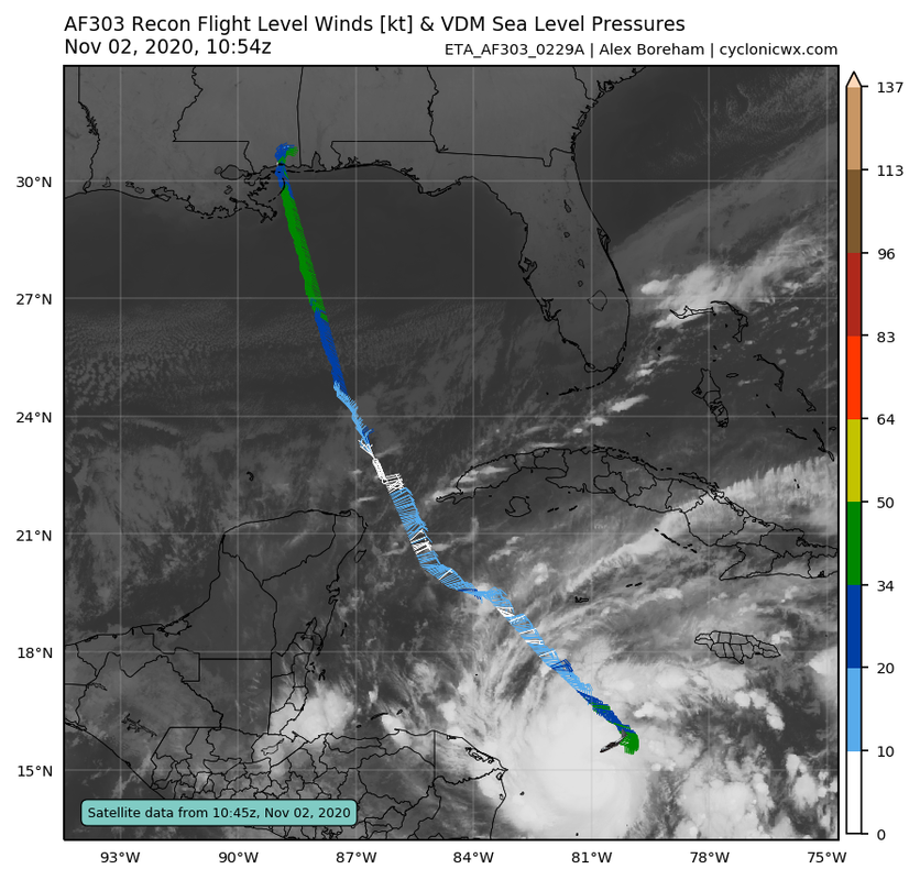
The thread is a bit quiet due to the current time, but together with Delta & maybe Teddy this is probably the most anticipated recon of the season. I'm afraid they'll find a rapidly strengthening major hurricane.
7 likes

Re: ATL: ETA - Hurricane - Discussion
I’m guessing they find a Cat 1/2 of 80-90 kt and 970-980 mbar.
2 likes
Irene '11 Sandy '12 Hermine '16 5/15/2018 Derecho Fay '20 Isaias '20 Elsa '21 Henri '21 Ida '21
I am only a meteorology enthusiast who knows a decent amount about tropical cyclones. Look to the professional mets, the NHC, or your local weather office for the best information.
I am only a meteorology enthusiast who knows a decent amount about tropical cyclones. Look to the professional mets, the NHC, or your local weather office for the best information.
-
supercane4867
- Category 5

- Posts: 4966
- Joined: Wed Nov 14, 2012 10:43 am

Re: ATL: ETA - Hurricane - Discussion
Let's see just how strong Eta has gotten since the last recon pass.
0 likes

Re: ATL: ETA - Hurricane - Discussion
Almost to a Cat 2, pressure down into the 970s
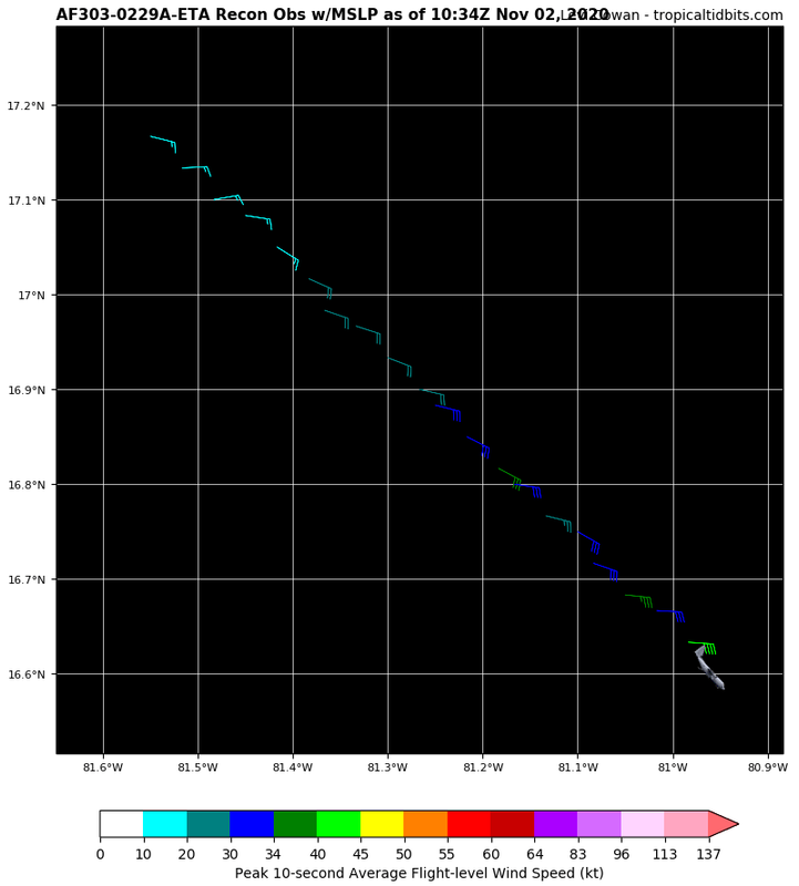
AF303 0229A ETA HDOB 25 20201102
110500 1510N 08048W 6969 03089 9990 +090 +013 116055 056 046 007 00
110530 1508N 08049W 6963 03086 9982 +090 +013 118058 060 048 007 00
110600 1507N 08050W 6973 03069 9970 +095 +012 120059 059 050 004 00
110630 1505N 08050W 6966 03071 9965 +092 +012 122062 065 052 005 00
110700 1504N 08052W 6970 03061 9956 +094 +013 121065 066 055 006 00
110730 1503N 08053W 6962 03060 9942 +095 +012 119069 070 058 009 00
110800 1501N 08054W 6969 03038 9938 +086 +011 117075 077 063 014 00
110830 1500N 08056W 6960 03021 9914 +086 +011 116082 085 068 024 00
110900 1459N 08057W 6965 03004 9878 +100 +013 119079 087 075 022 00
110930 1457N 08058W 6973 02967 9852 +098 +017 109075 078 080 018 00
111000 1456N 08100W 6963 02951 9827 +097 +020 092064 069 076 018 03
111030 1454N 08101W 6974 02920 9788 +109 +022 082052 061 071 018 00
111100 1452N 08102W 6970 02909 9746 +131 +025 060031 044 052 006 03
111130 1450N 08101W 6956 02931 9739 +136 +030 026014 024 029 002 03
111200 1450N 08100W 6960 02915 9749 +124 +039 218004 009 024 003 03
111230 1449N 08058W 6973 02908 9760 +118 +045 213017 020 021 004 03
111300 1447N 08059W 6969 02919 9769 +115 +047 228020 021 024 002 00
111330 1446N 08100W 6969 02920 9752 +132 +048 245015 019 026 004 00
111400 1445N 08102W 6969 02928 9742 +147 +050 288025 031 028 002 00
111430 1444N 08103W 6969 02938 9752 +149 +054 296043 047 041 001 00
$$
;
0 likes
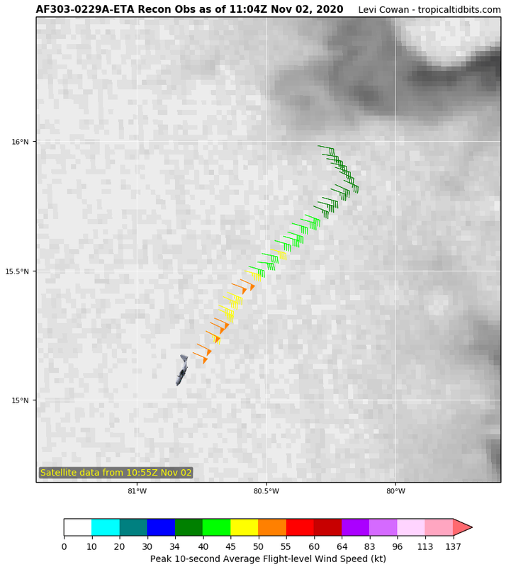
Re: ATL: ETA - Hurricane - Discussion
aspen wrote:I’m guessing they find a Cat 1/2 of 80-90 kt and 970-980 mbar.
Pretty much spot on; 80 kt and 975 mbar from this pass.
Since it’s much weaker than the Cat 3/4 that the HWRF originally had for this time, Eta is unlikely to stall over water, unfortunately. It remains to see how strong it’ll be at landfall, but the rain from this is going to be terrible no matter what.
0 likes
Irene '11 Sandy '12 Hermine '16 5/15/2018 Derecho Fay '20 Isaias '20 Elsa '21 Henri '21 Ida '21
I am only a meteorology enthusiast who knows a decent amount about tropical cyclones. Look to the professional mets, the NHC, or your local weather office for the best information.
I am only a meteorology enthusiast who knows a decent amount about tropical cyclones. Look to the professional mets, the NHC, or your local weather office for the best information.
-
supercane4867
- Category 5
- Posts: 4966
- Joined: Wed Nov 14, 2012 10:43 am

-
IsabelaWeather
- Category 1

- Posts: 316
- Age: 36
- Joined: Tue Jul 07, 2020 7:29 am
- Location: Isabela, Puerto Rico
Re: ATL: ETA - Tropical Storm - Discussion
abajan wrote:us89 wrote:If Eta were to follow the minimum strengthening rate for RI from here on out until it hits Nicaragua, assuming that happens at 7 AM Wednesday, it would strengthen 45 kt to a 105 kt peak at landfall.
That said, the ceiling is likely quite a bit higher than that - both because 1) this is very likely stronger than the 60 kt NHC is giving it now, and 2) conditions are near-perfect enough that we could see intensification rates well in excess of the 30kt/24hr threshold. Would not be surprised to see another cat 4 out of this.
Regardless of how strong it gets, the real story may be catastrophic flooding as it slows to a crawl over Central America. This is looking all-too-similar to Mitch.
While reading a bit on Mitch, I found this tragic and interesting. It so good that we have come a long way in forecasting these storms. I can't imagine what these people went through...
https://en.wikipedia.org/wiki/Fantome_(schooner)
On 24 October 1998, Fantome departed the harbor of Omoa, Honduras for a planned six-day cruise. Hurricane Mitch, then over 1,000 miles (1,600 km) away in the Caribbean Sea, was expected to pose a risk to Jamaica and possibly the Yucatán Peninsula. Captain Guyan March decided to play it safe by heading for the Bay Islands and wait for the storm to pass.
By dawn on the following day, however, Mitch seemed to change course. Fantome immediately changed course for Belize City, where it disembarked all of her passengers and non-essential crew members. The schooner then departed Belize City, first heading north towards the Gulf of Mexico, in order to outrun the storm. Storm predictions proved extremely difficult, as the steering currents in Hurricane Mitch were very weak. When word reached Fantome that Mitch would most likely hit the Yucatán before she could get out of harm's way, March changed course for the south. It was too early to know that he was heading directly into the storm's path.
The plan was to make for the lee side of the island of Roatan. In case Mitch made landfall in the Yucatán or Belize, by being on the southern side of the island, it would provide her with enough protection to hopefully keep it from getting damaged by large swells and high winds. However Mitch, now a Category 5 hurricane with winds up to 180 mph (285 km/h), took a jog towards the south, directly towards Roatan.
As Mitch moved in on Roatan and Honduras, Fantome made one desperate attempt to flee to safety, now heading east towards the Caribbean. Mitch's forward motion picked up, though, and Fantome was unable to outrun the storm. Around 4:30 p.m. on 27 October 1998, with Mitch having weakened but still at Category 5 intensity, Fantome reported that she was fighting 100-mile-per-hour (160 km/h) winds in 40-foot (12 m) seas. They were just 40 miles (64 km) south of Mitch's eyewall. Radio contact was lost with Fantome shortly after that.
On 2 November, a helicopter dispatched by the British destroyer HMS Sheffield discovered life rafts and vests labeled "S/V Fantome" off the eastern coast of Guanaja. It was all that was found of Fantome. All 31 crew members aboard perished and a memorial service was held for them on December 12, 1998.[2][3]
3 likes

Re: ATL: ETA - Hurricane - Discussion
Has there ever been a system that has crossed over from the Atlantic to the Pacific and then crossed back over to the Atlantic??
2 likes
Personal Forecast Disclaimer:
The posts in this forum are NOT official forecast and should not be used as such. They are just the opinion of the poster and may or may not be backed by sound meteorological data. They are NOT endorsed by any professional institution or storm2k.org. For official information, please refer to the NHC and NWS products.
The posts in this forum are NOT official forecast and should not be used as such. They are just the opinion of the poster and may or may not be backed by sound meteorological data. They are NOT endorsed by any professional institution or storm2k.org. For official information, please refer to the NHC and NWS products.

Re: ATL: ETA - Hurricane - Discussion
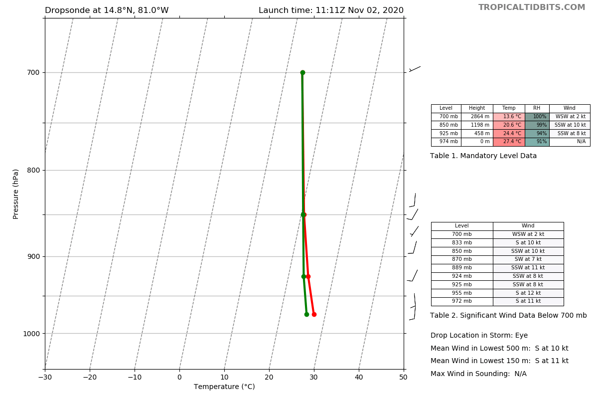
VDM reports a borderline pinhole
Eye circular and closed. 13 nm wide.
Eye circular and closed. 13 nm wide.
3 likes
-
Keldeo1997
- Category 2

- Posts: 688
- Joined: Fri Oct 11, 2019 11:35 pm

Re: ATL: ETA - Hurricane - Discussion
Impressive pressure drop in the last 18 hrs. MH at landfall is not out of the question at all.
0 likes
-
Keldeo1997
- Category 2
- Posts: 688
- Joined: Fri Oct 11, 2019 11:35 pm
-
hurricaneCW
- Category 5
- Posts: 1799
- Joined: Wed Mar 03, 2010 6:20 am
- Location: Toms River, NJ
Re: ATL: ETA - Hurricane - Discussion
NDG wrote:Impressive pressure drop in the last 18 hrs. MH at landfall is not out of the question at all.
It seems inevitable actually. Eta is moving rather slowly too giving it more time to deepen. I wouldn't be shocked at a Cat 4+ landfall.
5 likes

Who is online
Users browsing this forum: No registered users and 85 guests