Some important context for recent ECMWF runs:
https://twitter.com/yconsor/status/1323344132891398145
ATL: ETA - Models
Moderator: S2k Moderators
-
jconsor
- Professional-Met

- Posts: 580
- Joined: Mon Jun 30, 2008 9:31 pm
- Location: Jerusalem, Israel
- Contact:
Re: ATL: ETA - Models
1 likes


Re: ATL: ETA - Models
The 12z ECMWF asked: "what path could I take this storm on in order to maximize its time over high OHC? Maybe if I zig-zag it?"
4 likes
I'm a busy grad student, not a professional forecaster. Please refer to the NHC and NWS for official forecasts.
-
gatorcane

- S2K Supporter

- Posts: 23708
- Age: 48
- Joined: Sun Mar 13, 2005 3:54 pm
- Location: Boca Raton, FL
Re: ATL: ETA - Models
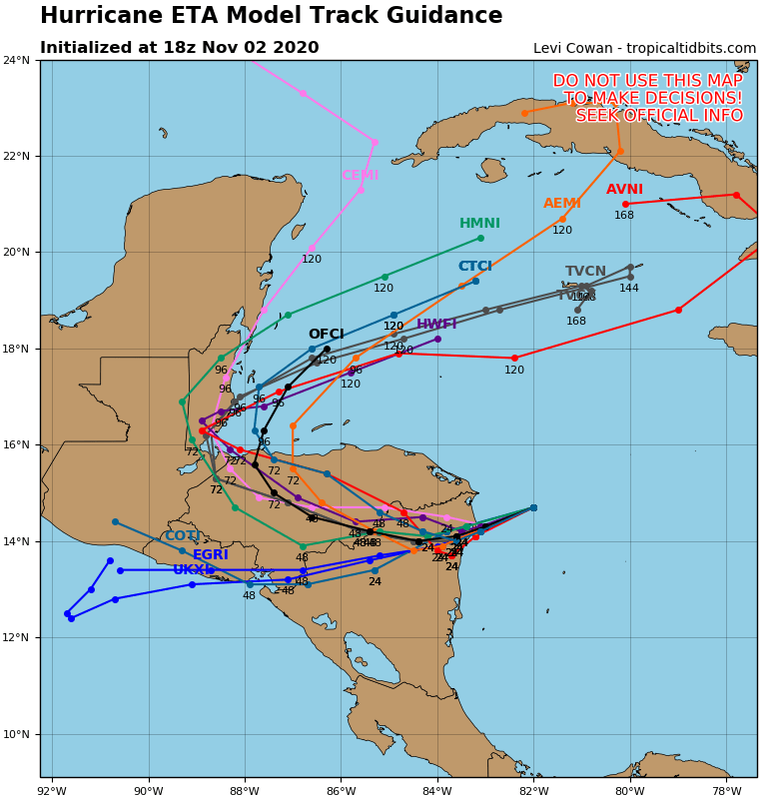
18Z. There is a distinct possibility ETA never makes it out of the Caribbean and if it does, would be a shell of its former self. Even a chance it doesn’t make it back into the Caribbean as the UKMET shows, though less of a chance.
Last edited by gatorcane on Mon Nov 02, 2020 2:34 pm, edited 2 times in total.
4 likes
-
Loveweather12
- Tropical Storm

- Posts: 136
- Joined: Thu Aug 20, 2020 2:37 pm
Re: ATL: ETA - Models
gatorcane wrote:18Z. There is a distinct possibility ETA never makes it out of the Caribbean and if it does, would be a shell of its former self.
https://i.postimg.cc/1XVszy6B/29-L-tracks-18z.png
Their is a possibility it does as their are plenty of models showing that. It will be a tricky forecast but I know I’m not discounting solutions or ruling anything out
1 likes
-
Spacecoast

- Category 2

- Posts: 773
- Joined: Thu Aug 31, 2017 2:03 pm
Re: ATL: ETA - Models
0 likes

-
DESTRUCTION5

- Category 5

- Posts: 4430
- Age: 44
- Joined: Wed Sep 03, 2003 11:25 am
- Location: Stuart, FL
Re: ATL: ETA - Models
SFLcane wrote:https://i.imgur.com/Sir5kiO.png
No ensembles east of Fl that represent a hurricane.
1 likes
GATOR NATION IS E V E R Y W H E R E !
-
SFLcane

- S2K Supporter
- Posts: 10281
- Age: 48
- Joined: Sat Jun 05, 2010 1:44 pm
- Location: Lake Worth Florida
Re: ATL: ETA - Models
TheStormExpert wrote::uarrow: That’s a shift west from 00z EPS.
Most head back east towards Florida.
0 likes

Re: ATL: ETA - Models
SFLcane wrote:TheStormExpert wrote::uarrow: That’s a shift west from 00z EPS.
Most head back east towards Florida.
Looks like the operational Euro slower than most of the ensembles - something to ponder sitting here on the west coast of Florida.
0 likes
-
gatorcane
- S2K Supporter
- Posts: 23708
- Age: 48
- Joined: Sun Mar 13, 2005 3:54 pm
- Location: Boca Raton, FL
Re: ATL: ETA - Models
TheStormExpert wrote::uarrow: That’s a shift west from 00z EPS.
They also looks considerably weaker than the operational which is clearly an outlier at 933mb.
2 likes
-
AutoPenalti
- Category 5
- Posts: 4091
- Age: 29
- Joined: Mon Aug 17, 2015 4:16 pm
- Location: Ft. Lauderdale, Florida
Re: ATL: ETA - Models
gatorcane wrote:TheStormExpert wrote::uarrow: That’s a shift west from 00z EPS.
They also looks considerably weaker than the operational which is clearly an outlier at 933mb.
I personally would rely on the HWRF for intensity once this is comes back over water.
0 likes
The posts in this forum are NOT official forecasts and should not be used as such. They are just the opinion of the poster and may or may not be backed by sound meteorological data. They are NOT endorsed by any professional institution or STORM2K. For official information, please refer to products from the NHC and NWS.
Model Runs Cheat Sheet:
GFS (5:30 AM/PM, 11:30 AM/PM)
HWRF, GFDL, UKMET, NAVGEM (6:30-8:00 AM/PM, 12:30-2:00 AM/PM)
ECMWF (1:45 AM/PM)
TCVN is a weighted averaged
Re: ATL: ETA - Models
SFLcane wrote:TheStormExpert wrote::uarrow: That’s a shift west from 00z EPS.
Most head back east towards Florida.
It would be hard to miss FL with that setup. Basically there is at 216 hours on the 12Z EPS a 500 mile wide target for landfall to its NE stretching from Pensacola to the S tip/Keys for many EPS members IF that were to be the actual setup then, which we know is merely intense speculation. And then there'd still be a wide range of potential well inland effects afterward that could affect especially the SE portions of AL, GA, SC, NC, and VA if it landfalls Big Bend or Panhandle vs mid to lower Peninsula. It really is amazing that the Panhandle might be so much in play in November. Kate of 1985 is the only other one like it this late. That kind of track is usually restricted to no later than mid October!!
2 likes
Personal Forecast Disclaimer:
The posts in this forum are NOT official forecasts and should not be used as such. They are just the opinion of the poster and may or may not be backed by sound meteorological data. They are NOT endorsed by any professional institution or storm2k.org. For official information, please refer to the NHC and NWS products.
The posts in this forum are NOT official forecasts and should not be used as such. They are just the opinion of the poster and may or may not be backed by sound meteorological data. They are NOT endorsed by any professional institution or storm2k.org. For official information, please refer to the NHC and NWS products.
-
toad strangler

- S2K Supporter
- Posts: 4546
- Joined: Sun Jul 28, 2013 3:09 pm
- Location: Earth
- Contact:
Re: ATL: ETA - Models
gatorcane wrote:TheStormExpert wrote::uarrow: That’s a shift west from 00z EPS.
They also looks considerably weaker than the operational which is clearly an outlier at 933mb.
Models don't forecast intensity well at all in the short range. This far out it's basically useless to look at intensity. CLIMO would agree with the weaker solutions though.
1 likes
My Weather Station
https://www.wunderground.com/dashboard/pws/KFLPORTS603
https://www.wunderground.com/dashboard/pws/KFLPORTS603
-
Spacecoast
- Category 2
- Posts: 773
- Joined: Thu Aug 31, 2017 2:03 pm


-
Spacecoast
- Category 2
- Posts: 773
- Joined: Thu Aug 31, 2017 2:03 pm
Re: ATL: ETA - Models
About 50% of the ECMF / GEFS Ensemble members never make it back out into Gulf of Honduras / Carribean.
I broke apart those that make it vs. those that don't (either dissipate, or into EPAC):
GEFS 15 members out of 32

GEFS 17 members out of 32

ECMF ~25 members out of 52

ECMF ~27 members out of 52

EDIT: I could not figure out why such a high % of ensemble members were showing this, and after some investigation, it appears that all these late cycle ensembles (both ECMF, & GEFS) were intialized prior to RI (980's). I don't know if the higher intensity will change this %, but the next ensemble run may change drastically.
I broke apart those that make it vs. those that don't (either dissipate, or into EPAC):
GEFS 15 members out of 32
GEFS 17 members out of 32
ECMF ~25 members out of 52
ECMF ~27 members out of 52
EDIT: I could not figure out why such a high % of ensemble members were showing this, and after some investigation, it appears that all these late cycle ensembles (both ECMF, & GEFS) were intialized prior to RI (980's). I don't know if the higher intensity will change this %, but the next ensemble run may change drastically.
Last edited by Spacecoast on Mon Nov 02, 2020 5:22 pm, edited 1 time in total.
2 likes
-
gatorcane
- S2K Supporter
- Posts: 23708
- Age: 48
- Joined: Sun Mar 13, 2005 3:54 pm
- Location: Boca Raton, FL
Re: ATL: ETA - Models
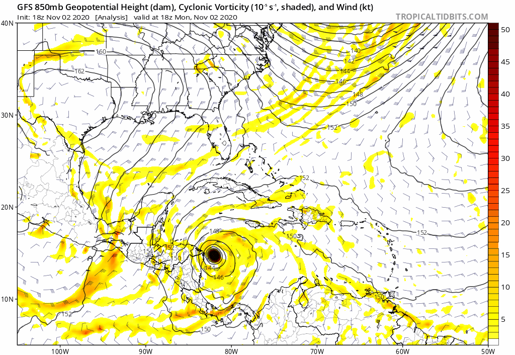
East shift by the GFS with a sloppy broad low as well. Looks more reasonable than the CAT 5 Euro storm which I think is not realistic:
1 likes
-
Blown Away

- S2K Supporter
- Posts: 10253
- Joined: Wed May 26, 2004 6:17 am
Re: ATL: ETA - Models
gatorcane wrote:East shift by the GFS with a sloppy broad low as well. Looks more reasonable than the CAT 5 Euro storm which I think is not realistic:
https://i.postimg.cc/prT0KBBX/gfs-z850-vort-watl-fh0-168.gif
The models are starting to push Eta farther E after emerging off Honduras to @75W and then turn around back WNW or NW. Very unusual track.
1 likes
Hurricane Eye Experience: David 79, Irene 99, Frances 04, Jeanne 04, Wilma 05… Hurricane Brush Experience: Andrew 92, Erin 95, Floyd 99, Matthew 16, Irma 17, Ian 22, Nicole 22…
Who is online
Users browsing this forum: No registered users and 111 guests