 this is insanity
 Sent from my SM-N986U1 using Tapatalk
Moderator: S2k Moderators

 this is insanity
 Owasso wrote:https://i.postimg.cc/SsgZ7p6F/image.png


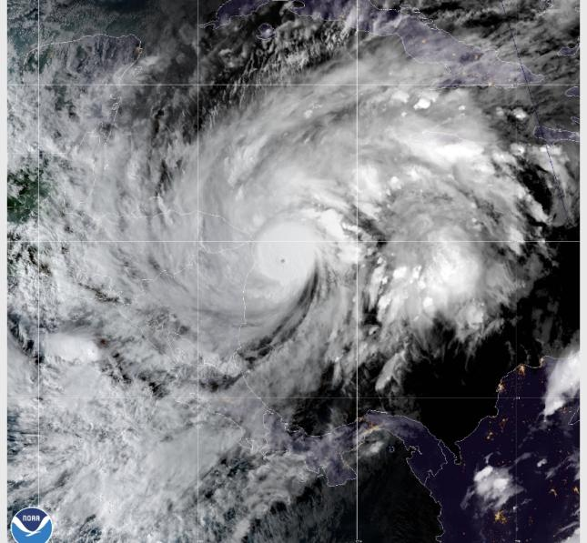
2020NOV02 225017 5.9 948.3 112.4 5.9 6.3 7.1 1.3T/6hr OFF OFF OFF OFF -35.96 -77.18 EYE 6 IR 20.0 14.39 82.33 ARCHER GOES16 18.8


Cunxi Huang wrote:2020NOV02 225017 5.9 948.3 112.4 5.9 6.3 7.1 1.3T/6hr OFF OFF OFF OFF -35.96 -77.18 EYE 6 IR 20.0 14.39 82.33 ARCHER GOES16 18.8


Iceresistance wrote:Cunxi Huang wrote:2020NOV02 225017 5.9 948.3 112.4 5.9 6.3 7.1 1.3T/6hr OFF OFF OFF OFF -35.96 -77.18 EYE 6 IR 20.0 14.39 82.33 ARCHER GOES16 18.8
CAT 5!
cjrciadt wrote:Owasso wrote:https://i.postimg.cc/SsgZ7p6F/image.png
Does look like an SPAC super typhoon indeed vs an NA cane


Cunxi Huang wrote:2020NOV02 225017 5.9 948.3 112.4 5.9 6.3 7.1 1.3T/6hr OFF OFF OFF OFF -35.96 -77.18 EYE 6 IR 20.0 14.39 82.33 ARCHER GOES16 18.8

jackdets wrote:Iceresistance wrote:Cunxi Huang wrote:
CAT 5!
That's the RAW T, which is typically not used. Instead, usually the Adj T (6.3) or Final T (5.9) are used
CrazyC83 wrote:I'm sure there is a lot of debate on what the NHC will go with at the intermediate.
Ian2401 wrote:AutoPenalti wrote:Looks like it stalled? Seems to be wobbling now.
probably trochoidal wobble giving the illusion of a stall
jackdets wrote:Iceresistance wrote:Cunxi Huang wrote:
CAT 5!
That's the RAW T, which is typically not used. Instead, usually the Adj T (6.3) or Final T (5.9) are used

CrazyC83 wrote:I'm sure there is a lot of debate on what the NHC will go with at the intermediate.
edu2703 wrote:CrazyC83 wrote:I'm sure there is a lot of debate on what the NHC will go with at the intermediate.
Probably 120-130 knots


Users browsing this forum: No registered users and 16 guests


