ATL: ETA - Post-Tropical - Discussion
Moderator: S2k Moderators
-
Kingarabian

- S2K Supporter

- Posts: 16336
- Joined: Sat Aug 08, 2009 3:06 am
- Location: Honolulu, Hawaii
Re: ATL: ETA - Hurricane - Discussion
While I think Eta having super cold tops due to Troposphere temperatures changing around November, I think the majority of us were not baseless with ours estimates. Patricia formed and peaked between Oct20-Oct24 while Haiyan formed and peaked between Nov4-Nov11. The only real difference is that Patricia and Haiyan had warmer eyes. Something we can discuss during the off season.
2 likes
RIP Kobe Bryant

Re: ATL: ETA - Hurricane - Discussion
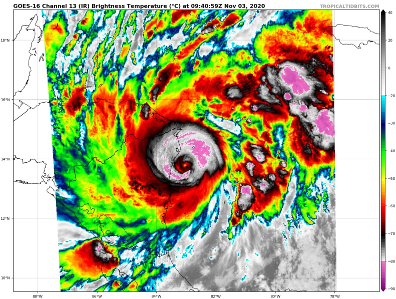
On the MODIS high-resolution image around 04Z, we can see that although Eta's eye temperature is warm (>10C), on the water vapor image its hue is just a bluish green. On the contrary, strong hurricanes typically have a blue water vapor eye, and Patricia's was even indigo in the MODIS image.
Usually, as long as an eye is cloud-free, the IR image will capture an eye temperature that's roughly the sea surface temperature or that of low-level clouds, so beyond a certain point there's little differentiation. Water vapor images, on the other hand, are dependent on the precise air temperature and humidity of the air parcel at mid-level, so it would be a better indicator of the subsidence within the eye, and thus of the intensity of a hurricane's warm core. Eta's poor water vapor eye despite a warm WMG eye might explain why its intensity seems to be lower than what satellite imagery suggests on first glance.
Usually, as long as an eye is cloud-free, the IR image will capture an eye temperature that's roughly the sea surface temperature or that of low-level clouds, so beyond a certain point there's little differentiation. Water vapor images, on the other hand, are dependent on the precise air temperature and humidity of the air parcel at mid-level, so it would be a better indicator of the subsidence within the eye, and thus of the intensity of a hurricane's warm core. Eta's poor water vapor eye despite a warm WMG eye might explain why its intensity seems to be lower than what satellite imagery suggests on first glance.
3 likes


Re: ATL: ETA - Hurricane - Discussion
Pink Ring starting to form back and the eye is warming, Eye looks larger then before.
1 likes
-
JamesRainier
Re: ATL: ETA - Hurricane - Discussion
Not official landfall, but the local observation is noteworthy.
https://twitter.com/juliecupples79/status/1323570466985037826
https://twitter.com/juliecupples79/status/1323570466985037826
2 likes
-
USTropics
- Professional-Met

- Posts: 2735
- Joined: Sun Aug 12, 2007 3:45 am
- Location: Florida State University
Re: ATL: ETA - Hurricane - Discussion
There was definitely an outer eyewall (concentric eyewall, highlighted in red) that formed and is evident on radar images from San Andres Island earlier this morning. I've outlined the previous eyewall (yellow) that was evident yesterday when the pinhole developed and underwent RI.

Original image

Radar loop
http://meteorologia.aerocivil.gov.co/radar/loop/aoi/ADZ/Reflectividad%20de%20Base%200.5%20deg?scroll_x=0&scroll_y=0&loop_speed=4.0&endDelay=1&startDelay=0&start_date=&end_date=&image_blacklist%5B%5D=
Original image
Radar loop
http://meteorologia.aerocivil.gov.co/radar/loop/aoi/ADZ/Reflectividad%20de%20Base%200.5%20deg?scroll_x=0&scroll_y=0&loop_speed=4.0&endDelay=1&startDelay=0&start_date=&end_date=&image_blacklist%5B%5D=
2 likes


Re: ATL: ETA - Hurricane - Discussion
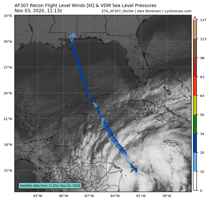
Recon is getting really close — they should start descending to operational altitude soon. This is its last chance to get upgraded to a Cat 5 operationally, although it has an even better shot than Laura for a post-season upgrade for a few reasons:
—Recon was unable to sample Eta as it continued rapid deepening, and they never sampled the NW quadrant
—Last night’s intensification rate of 4 mb/hr meant this could’ve gotten into the 910s before the EWRC
—Despite missing the max wind area, a dropsonde did record Cat 5 winds at the surface
—Recon was unable to sample Eta as it continued rapid deepening, and they never sampled the NW quadrant
—Last night’s intensification rate of 4 mb/hr meant this could’ve gotten into the 910s before the EWRC
—Despite missing the max wind area, a dropsonde did record Cat 5 winds at the surface
4 likes
Irene '11 Sandy '12 Hermine '16 5/15/2018 Derecho Fay '20 Isaias '20 Elsa '21 Henri '21 Ida '21
I am only a meteorology enthusiast who knows a decent amount about tropical cyclones. Look to the professional mets, the NHC, or your local weather office for the best information.
I am only a meteorology enthusiast who knows a decent amount about tropical cyclones. Look to the professional mets, the NHC, or your local weather office for the best information.

-
euro6208
Re: ATL: ETA - Hurricane - Discussion
At this point a 10 knot increase to a cat 5 doesn't matter. 4 and 5 is just utter destruction. The damage will be equal.
3 likes

Re: ATL: ETA - Hurricane - Discussion
Eyewall replacement cycle before landfall so won't have time to recover that should help although the windfields with cat 2 winds will be larger.
0 likes
-
JamesRainier

Re: ATL: ETA - Hurricane - Discussion
Last chance for a cat 5 update before the post-season. Considering the EWRC I doubt they'll find cat 5 winds, but you never know.
0 likes
-
tolakram
- Admin

- Posts: 20170
- Age: 62
- Joined: Sun Aug 27, 2006 8:23 pm
- Location: Florence, KY (name is Mark)
Re: ATL: ETA - Hurricane - Discussion
JamesRainier wrote:https://twitter.com/TorenWX/status/1323573773115817984?s=20
Unacceptable? I'm getting tired of all the hand wringing and over the top comments concerning recon. It is what it is. Also keep in mind if you post a tweet you are responsible for it's contents following S2K rules. This one, along with some other posts last night, are borderline. Recon is there to give us data, and we love data, but I don't see recon changing the forecast or helping people avoid landfall. Let's keep this in perspective please.
Also, does Canada have planes we can use?
11 likes
M a r k
- - - - -
Join us in chat: Storm2K Chatroom Invite. Android and IOS apps also available.
The posts in this forum are NOT official forecasts and should not be used as such. Posts are NOT endorsed by any professional institution or STORM2K.org. For official information and forecasts, please refer to NHC and NWS products.
Re: ATL: ETA - Hurricane - Discussion
Eta’s pressure gradient is probably going to look really weird with the EWRC ongoing.
0 likes
Irene '11 Sandy '12 Hermine '16 5/15/2018 Derecho Fay '20 Isaias '20 Elsa '21 Henri '21 Ida '21
I am only a meteorology enthusiast who knows a decent amount about tropical cyclones. Look to the professional mets, the NHC, or your local weather office for the best information.
I am only a meteorology enthusiast who knows a decent amount about tropical cyclones. Look to the professional mets, the NHC, or your local weather office for the best information.
Re: ATL: ETA - Hurricane - Discussion
From a scientific perspective this will be a very interesting recon mission. I don't think it happens often that we get real data from a landfalling major hurricane experiencing an EWRC.
2 likes
-
crownweather

- S2K Supporter
- Posts: 602
- Age: 51
- Joined: Sat Aug 12, 2006 9:21 am
- Location: Sturbridge, Massachusetts
- Contact:
Re: ATL: ETA - Hurricane - Discussion
tolakram wrote:JamesRainier wrote:https://twitter.com/TorenWX/status/1323573773115817984?s=20
Unacceptable? I'm getting tired of all the hand wringing and over the top comments concerning recon. It is what it is. Also keep in mind if you post a tweet you are responsible for it's contents following S2K rules. This one, along with some other posts last night, are borderline. Recon is there to give us data, and we love data, but I don't see recon changing the forecast or helping people avoid landfall. Let's keep this in perspective please.
Also, does Canada have planes we can use?
I'd like to piggy back on this if I could. It is ALWAYS safety over data when it comes to recon flights. If there's a "sick" bird in anyway, they aren't going to fly, period! I also have heard "rumors" that the plane that actually got a couple of passes encountered such severe turbulence that the plane stalled at one point. If you have ever tried flying a plane & purposely put it in a stall for training, it's very unnerving and scary (I have). So, the reason (based on rumor) they turned back is that they didn't want to tempt fate again.
Is the data from recon great? Absolutely! But, I'd rather glean my data from satellite imagery than see a plane go down & lose a crew.
8 likes
Rob Lightbown
Crown Weather Services
https://crownweather.com
Crown Weather Services
https://crownweather.com


Who is online
Users browsing this forum: No registered users and 24 guests