ATL: ETA - Models
Moderator: S2k Moderators
-
Dean4Storms
- S2K Supporter

- Posts: 6358
- Age: 62
- Joined: Sun Aug 31, 2003 1:01 pm
- Location: Miramar Bch. FL
Re: ATL: ETA - Models
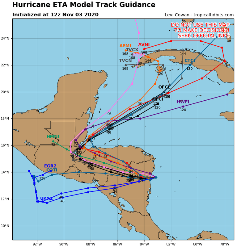
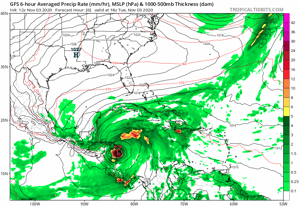
Basically it looks like either Eta's remnant Low or another Low is going to form in the Western Carib. and struggle as it moves NNE but out around 144 hours a large Eastern North American Ridge extending out into the Atlantic turns this TC westward. How far this TC gets westward in the Gulf and latitude gained before the next Trough comes Eastward looks to be the determining factor where landfall might eventually end up in the Gulf. I would caution everyone from LA through Florida to stay up on this one.
4 likes

Re: ATL: ETA - Models
Looking long term, the remnants of Eta look more like a sub-tropical system when it heads towards the northeast. So far none of the models show it getting stacked, so a signficant storm down tbe road is looking less likeky. I am not even convinced something will re-develop now.
It won't be until Thursday if not later before something re-emerges and possibly organizes. Until then, this is a guessing game.
That said, it is going to be a bad week for Nicaragua and Hondorus. Given their infrastructure and lack of resources for disaster response, this could be as bad as Mitch or worse.
0 likes
-
gatorcane

- S2K Supporter
- Posts: 23703
- Age: 47
- Joined: Sun Mar 13, 2005 3:54 pm
- Location: Boca Raton, FL
Re: ATL: ETA - Models
ETA bumping into the “Florida High” aka the “SE Ridge” as TVCN bends west near Cuba. We really need to see what is left of ETA as it will take a beating over the mountainous terrain of CA to see how models respond as far as intensity and track.
0 likes
-
stormchazer

- Category 5

- Posts: 2462
- Joined: Fri Aug 29, 2003 12:00 pm
- Location: Lakeland, Florida
- Contact:
Re: ATL: ETA - Models
otowntiger wrote:chris_fit wrote:Everyone's been busy in the Discussion Thread (and understandable so.)
As the models move from the long-range to the mid-range in terms of possible US impacts, honestly not much has changed in the last 2 days in terms of Track. Intensity is a big who knows, so I won't even go there right now.
Based on the Ensemble Runs over the last ~2 days (I'm simply not paying much attention to the operational runs of the CMC/EURO/GFS yet as they are all over the place) - Eta/Theta is expected to (re)develop in the NW Caribbean, meander N/NE into/around Cuba, Turn W/WNW into the GoM and eventually turn NE into anywhere from the Northeastern Gulf Coast through the Keys.
The above is based on the Ensemble Runs - I'm simply not paying much attention to the operational runs of the CMC/EURO/GFS yet. What is interesting (and unusual for this year) is that the EURO is most bullish on this in the Mid/Long range.
Below are Day 2 - Day 10 Ensemble runs (most recent)
Latest 00Z CMC ENS
https://i.imgur.com/7UcbgIU.gif
Latest 06Z GFS ENS
https://i.imgur.com/yr4o2z7.gif
Latest 00Z EURO ENS
https://i.imgur.com/oNrWZH8.gif
Great post boiling it all down in one good summary. It does seem that there is a general agreement on general track set up. I know you said, rightfully so, that intensity is a big unknown as proven again and again this season that is a part of tropical predictions that we have yet to fully grasp. But it is really no less important than track, in my opinion. They could nail the track perfectly but predict a major storm when it could very well be a sloppy blob of rain instead- or vice versa, and have failed in my opinion. With that said intensity ‘guessing’ is still worth talking about. I think the good thing is there is a very good chance. 50/50 or better that ETA could be a weak unsubstantial system by the time it finally begins to affect the CONUS. I say that because cooler SST’s in the gulf, shear from approaching fronts and land interaction all will work together against intensity once it begins to emerge from the Caribbean. Of it could thread the needle so to speak and hit that proverbial sweet spot and become something significant despite the afore mentioned hurdles, I just think odds are against that from my perspective.
I agree but then remember this is 2020 and nothing has gone right this year.
0 likes
The posts or stuff said are NOT an official forecast and my opinion alone. Please look to the NHC and NWS for official forecasts and products.
Model Runs Cheat Sheet:
GFS (5:30 AM/PM, 11:30 AM/PM)
HWRF, GFDL, UKMET, NAVGEM (6:30-8:00 AM/PM, 12:30-2:00 AM/PM)
ECMWF (1:45 AM/PM)
TCVN is a weighted averaged
Opinions my own.
Model Runs Cheat Sheet:
GFS (5:30 AM/PM, 11:30 AM/PM)
HWRF, GFDL, UKMET, NAVGEM (6:30-8:00 AM/PM, 12:30-2:00 AM/PM)
ECMWF (1:45 AM/PM)
TCVN is a weighted averaged
Opinions my own.
-
SouthFLTropics

- Category 5
- Posts: 4258
- Age: 50
- Joined: Thu Aug 14, 2003 8:04 am
- Location: Port St. Lucie, Florida
Re: ATL: ETA - Models
ICON brings this into the Bahamas before swinging it back west into the Florida East Coast as a hurricane.

0 likes
Fourth Generation Florida Native
Personal Storm History: David 79, Andrew 92, Erin 95, Floyd 99, Irene 99, Frances 04, Jeanne 04, Wilma 05, Matthew 16, Irma 17, Ian 22, Nicole 22, Milton 24
Personal Storm History: David 79, Andrew 92, Erin 95, Floyd 99, Irene 99, Frances 04, Jeanne 04, Wilma 05, Matthew 16, Irma 17, Ian 22, Nicole 22, Milton 24
-
gatorcane
- S2K Supporter
- Posts: 23703
- Age: 47
- Joined: Sun Mar 13, 2005 3:54 pm
- Location: Boca Raton, FL
Re: ATL: ETA - Models
12Z GFS animation. Looks like there is some interaction with a ULL/trough in the Gulf which allows the storm to “pivot” around into Florida (not shown). It is worth noting the last several runs of the GFS have trended a bit stronger but stays at a tropical storms through day 5.
Last edited by gatorcane on Tue Nov 03, 2020 11:09 am, edited 4 times in total.
0 likes
-
Hypercane_Kyle

- Category 5
- Posts: 3465
- Joined: Sat Mar 07, 2015 7:58 pm
- Location: Cape Canaveral, FL
Re: ATL: ETA - Models
Worth noting the 12z GFS is considerably different from the NHC forecast in terms of timing.
12z GFS has Eta inland over Florida by 120 hours. NHC forecast is still in the Caribbean and is similar to the Euro. The latter would likely result in a stronger, more consolidated system IMO.
12z GFS has Eta inland over Florida by 120 hours. NHC forecast is still in the Caribbean and is similar to the Euro. The latter would likely result in a stronger, more consolidated system IMO.
1 likes
My posts are my own personal opinion, defer to the National Hurricane Center (NHC) and other NOAA products for decision making during hurricane season.
-
SouthFLTropics
- Category 5
- Posts: 4258
- Age: 50
- Joined: Thu Aug 14, 2003 8:04 am
- Location: Port St. Lucie, Florida
Re: ATL: ETA - Models
In the FWIW column, the NAVGEM is similar to ICON, albeit stronger.

0 likes
Fourth Generation Florida Native
Personal Storm History: David 79, Andrew 92, Erin 95, Floyd 99, Irene 99, Frances 04, Jeanne 04, Wilma 05, Matthew 16, Irma 17, Ian 22, Nicole 22, Milton 24
Personal Storm History: David 79, Andrew 92, Erin 95, Floyd 99, Irene 99, Frances 04, Jeanne 04, Wilma 05, Matthew 16, Irma 17, Ian 22, Nicole 22, Milton 24
-
SouthFLTropics
- Category 5
- Posts: 4258
- Age: 50
- Joined: Thu Aug 14, 2003 8:04 am
- Location: Port St. Lucie, Florida
Re: ATL: ETA - Models
So far, 12z ICON, NAVGEM, and GFS have the same general idea. From Central America to the NE with a bend back to the west. Two big questions remain... Where does the bend back west take place, and what will Eta be when it does that?
0 likes
Fourth Generation Florida Native
Personal Storm History: David 79, Andrew 92, Erin 95, Floyd 99, Irene 99, Frances 04, Jeanne 04, Wilma 05, Matthew 16, Irma 17, Ian 22, Nicole 22, Milton 24
Personal Storm History: David 79, Andrew 92, Erin 95, Floyd 99, Irene 99, Frances 04, Jeanne 04, Wilma 05, Matthew 16, Irma 17, Ian 22, Nicole 22, Milton 24
-
gatorcane
- S2K Supporter
- Posts: 23703
- Age: 47
- Joined: Sun Mar 13, 2005 3:54 pm
- Location: Boca Raton, FL
Re: ATL: ETA - Models
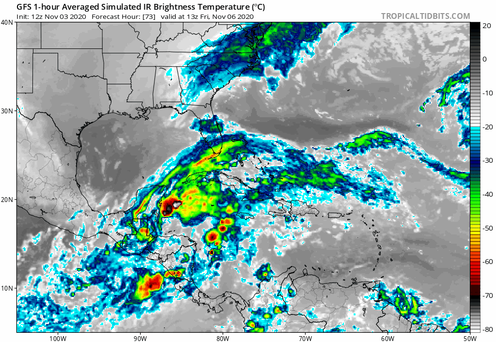
Looks almost subtropical on the GFS IR simulation and sheared. Most of the convection in the Bahamas with barely anything over Florida.
Last edited by gatorcane on Tue Nov 03, 2020 11:19 am, edited 1 time in total.
0 likes

Re: ATL: ETA - Models
It's still a while until a possible reformation after landfall can happen, but MPI atm is very high for the NWCar. Especially if Eta gets organized quickly, so well before a landfall on Cuba, it might have exceptionally optimal conditions for intensification depending on shear.

2 likes
Re: ATL: ETA - Models
stormchazer wrote:otowntiger wrote:chris_fit wrote:Everyone's been busy in the Discussion Thread (and understandable so.)
As the models move from the long-range to the mid-range in terms of possible US impacts, honestly not much has changed in the last 2 days in terms of Track. Intensity is a big who knows, so I won't even go there right now.
Based on the Ensemble Runs over the last ~2 days (I'm simply not paying much attention to the operational runs of the CMC/EURO/GFS yet as they are all over the place) - Eta/Theta is expected to (re)develop in the NW Caribbean, meander N/NE into/around Cuba, Turn W/WNW into the GoM and eventually turn NE into anywhere from the Northeastern Gulf Coast through the Keys.
The above is based on the Ensemble Runs - I'm simply not paying much attention to the operational runs of the CMC/EURO/GFS yet. What is interesting (and unusual for this year) is that the EURO is most bullish on this in the Mid/Long range.
Below are Day 2 - Day 10 Ensemble runs (most recent)
Latest 00Z CMC ENS
https://i.imgur.com/7UcbgIU.gif
Latest 06Z GFS ENS
https://i.imgur.com/yr4o2z7.gif
Latest 00Z EURO ENS
https://i.imgur.com/oNrWZH8.gif
Great post boiling it all down in one good summary. It does seem that there is a general agreement on general track set up. I know you said, rightfully so, that intensity is a big unknown as proven again and again this season that is a part of tropical predictions that we have yet to fully grasp. But it is really no less important than track, in my opinion. They could nail the track perfectly but predict a major storm when it could very well be a sloppy blob of rain instead- or vice versa, and have failed in my opinion. With that said intensity ‘guessing’ is still worth talking about. I think the good thing is there is a very good chance. 50/50 or better that ETA could be a weak unsubstantial system by the time it finally begins to affect the CONUS. I say that because cooler SST’s in the gulf, shear from approaching fronts and land interaction all will work together against intensity once it begins to emerge from the Caribbean. Of it could thread the needle so to speak and hit that proverbial sweet spot and become something significant despite the afore mentioned hurdles, I just think odds are against that from my perspective.
I agree but then remember this is 2020 and nothing has gone right this year.
And....it's election day...

0 likes
-
SFLcane

- S2K Supporter
- Posts: 10281
- Age: 48
- Joined: Sat Jun 05, 2010 1:44 pm
- Location: Lake Worth Florida
Re: ATL: ETA - Models
991 mb on the GFS into Florida a case can be made it’s a minimal hurricane. Either way models trending stronger

1 likes

-
gatorcane
- S2K Supporter
- Posts: 23703
- Age: 47
- Joined: Sun Mar 13, 2005 3:54 pm
- Location: Boca Raton, FL
Re: ATL: ETA - Models
12Z CMC like the GFS shows a sheared system possibly transitioning to subtropical with the convection over the Bahamas.
0 likes
-
SouthFLTropics
- Category 5
- Posts: 4258
- Age: 50
- Joined: Thu Aug 14, 2003 8:04 am
- Location: Port St. Lucie, Florida
Re: ATL: ETA - Models
I think we may see a sheared mess coming across Cuba. What potentially concerns me is that mess getting trapped in the Bahamas and turning back west under better conditions. We've seen how strong these things can get on short notice. Given the right environment in the Bahamas, it could bomb out.
0 likes
Fourth Generation Florida Native
Personal Storm History: David 79, Andrew 92, Erin 95, Floyd 99, Irene 99, Frances 04, Jeanne 04, Wilma 05, Matthew 16, Irma 17, Ian 22, Nicole 22, Milton 24
Personal Storm History: David 79, Andrew 92, Erin 95, Floyd 99, Irene 99, Frances 04, Jeanne 04, Wilma 05, Matthew 16, Irma 17, Ian 22, Nicole 22, Milton 24


-
TheStormExpert
Re: ATL: ETA - Models
SFLcane wrote:991 mb on the GFS into Florida a case can be made it’s a minimal hurricane. Either way models trending stronger
https://i.imgur.com/i8sD9h7.jpg
That’s a Subtropical Storm not a hurricane.
0 likes
-
SFLcane
- S2K Supporter
- Posts: 10281
- Age: 48
- Joined: Sat Jun 05, 2010 1:44 pm
- Location: Lake Worth Florida
Re: ATL: ETA - Models
TheStormExpert wrote:SFLcane wrote:991 mb on the GFS into Florida a case can be made it’s a minimal hurricane. Either way models trending stronger
https://i.imgur.com/i8sD9h7.jpg
That’s a Subtropical Storm not a hurricane.
Impacts are the same to the average person. Rain wind enough to knock your power out.
Either way 12z models trending stronger
0 likes

Re: ATL: ETA - Models
gatorcane wrote:Looks almost subtropical on the GFS IR simulation and sheared. Most of the convection in the Bahamas with barely anything over Florida.
https://i.postimg.cc/nz1j0SmJ/gfs-ir-watl-fh73-115.gif
How do you get the satellite presentation on the GFS model?
0 likes
Who is online
Users browsing this forum: No registered users and 148 guests