ATL: ETA - Models
Moderator: S2k Moderators
-
Blown Away

- S2K Supporter

- Posts: 10253
- Joined: Wed May 26, 2004 6:17 am
Re: ATL: ETA - Models
Looks like 12z HWRF/HMON go into the EPAC.
0 likes
Hurricane Eye Experience: David 79, Irene 99, Frances 04, Jeanne 04, Wilma 05… Hurricane Brush Experience: Andrew 92, Erin 95, Floyd 99, Matthew 16, Irma 17, Ian 22, Nicole 22…
-
SFLcane

- S2K Supporter
- Posts: 10281
- Age: 48
- Joined: Sat Jun 05, 2010 1:44 pm
- Location: Lake Worth Florida
Re: ATL: ETA - Models
Blown Away wrote:Looks like 12z HWRF/HMON go into the EPAC.
No, hwrf is in the nw Caribbean Sea.
1 likes
-
AutoPenalti
- Category 5

- Posts: 4091
- Age: 29
- Joined: Mon Aug 17, 2015 4:16 pm
- Location: Ft. Lauderdale, Florida
Re: ATL: ETA - Models
Blown Away wrote:Looks like 12z HWRF/HMON go into the EPAC.
Looks like the HWRF sees a center reforming off the coast of Honduras.
0 likes
The posts in this forum are NOT official forecasts and should not be used as such. They are just the opinion of the poster and may or may not be backed by sound meteorological data. They are NOT endorsed by any professional institution or STORM2K. For official information, please refer to products from the NHC and NWS.
Model Runs Cheat Sheet:
GFS (5:30 AM/PM, 11:30 AM/PM)
HWRF, GFDL, UKMET, NAVGEM (6:30-8:00 AM/PM, 12:30-2:00 AM/PM)
ECMWF (1:45 AM/PM)
TCVN is a weighted averaged
-
SFLcane
- S2K Supporter
- Posts: 10281
- Age: 48
- Joined: Sat Jun 05, 2010 1:44 pm
- Location: Lake Worth Florida
Re: ATL: ETA - Models
AutoPenalti wrote:Blown Away wrote:Looks like 12z HWRF/HMON go into the EPAC.
Looks like the HWRF sees a center reforming off the coast of Honduras.
And stronger..
0 likes
Re: ATL: ETA - Models
COAMPS ens

4 likes
Personal Forecast Disclaimer:
The posts in this forum are NOT official forecasts and should not be used as such. They are just the opinion of the poster and may or may not be backed by sound meteorological data. They are NOT endorsed by any professional institution or storm2k.org. For official information, please refer to the NHC and NWS products.
The posts in this forum are NOT official forecasts and should not be used as such. They are just the opinion of the poster and may or may not be backed by sound meteorological data. They are NOT endorsed by any professional institution or storm2k.org. For official information, please refer to the NHC and NWS products.
-
Spacecoast

- Category 2

- Posts: 773
- Joined: Thu Aug 31, 2017 2:03 pm
Re: ATL: ETA - Models
aspen wrote:I’m getting a little concerned how the NHC forecast and some of the models don’t show Eta getting as far east anymore. Perhaps there’s a slim possibility of Eta getting blocked in the Caribbean, although a more likely outcome of a less east track is a longer time frame bringing impacts to Cuba and Florida.
This is a good point. It appears that NHC is taking a 'less east' track, along with pushing out the the time frame. Although wind impacts are of some concern, S. Florida should be more concerned about a TS spinning for a longer period of time off the SW tip of FL.
1 likes

-
Spacecoast
- Category 2
- Posts: 773
- Joined: Thu Aug 31, 2017 2:03 pm
Re: ATL: ETA - Models
A side note:
12z GFS hits Nicaragua again with another storm on Nov 20th
0z Para hits keys (again?) with another storm on Nov 19th
Is there no end in sight?
12z GFS hits Nicaragua again with another storm on Nov 20th
0z Para hits keys (again?) with another storm on Nov 19th
Is there no end in sight?
1 likes
-
TheStormExpert
Re: ATL: ETA - Models
12z HWRF is weaker than 06z and through the Gulf Stream just east of Palm Beach in 96hrs @ 984mbs. Keeps the worst weather offshore and over Grand Bahama Island.

0 likes


Re: ATL: ETA - Models
TheStormExpert wrote:12z HWRF is weaker than 06z and through the Gulf Stream just east of Palm Beach in 96hrs @ 984mbs. Keeps the worst weather offshore and over Grand Bahama Island.
https://i.imgur.com/XfXD0cN.png
Thats a prime spot for it to gather some strength, all depending upon how disorganized it is at that point.
3 likes
-
TheStormExpert
Re: ATL: ETA - Models
12z Euro turns this NW after exiting Cuba just SW of Florida in 4-5 days as a strengthening hurricane.
0 likes
-
TheStormExpert
Re: ATL: ETA - Models
So the 12z GFS has Eta near the north tip of Andros Island in The Bahamas in 5 days, while the 12z Euro has Eta just west of Key West at the same time.
Maybe a compromise up the peninsula some before turning NW or West is the best bet at the moment?
Maybe a compromise up the peninsula some before turning NW or West is the best bet at the moment?
0 likes
-
TheStormExpert
Re: ATL: ETA - Models
jdray wrote:TheStormExpert wrote:12z HWRF is weaker than 06z and through the Gulf Stream just east of Palm Beach in 96hrs @ 984mbs. Keeps the worst weather offshore and over Grand Bahama Island.
https://i.imgur.com/XfXD0cN.png
Thats a prime spot for it to gather some strength, all depending upon how disorganized it is at that point.
Yep. Gulf Stream waters just off Palm beach are around 83-84°F.
0 likes
Re: ATL: ETA - Models
Spacecoast wrote:A side note:
12z GFS hits Nicaragua again with another storm on Nov 20th
0z Para hits keys (again?) with another storm on Nov 19th
Is there no end in sight?
Say it isn't so...
0 likes

-
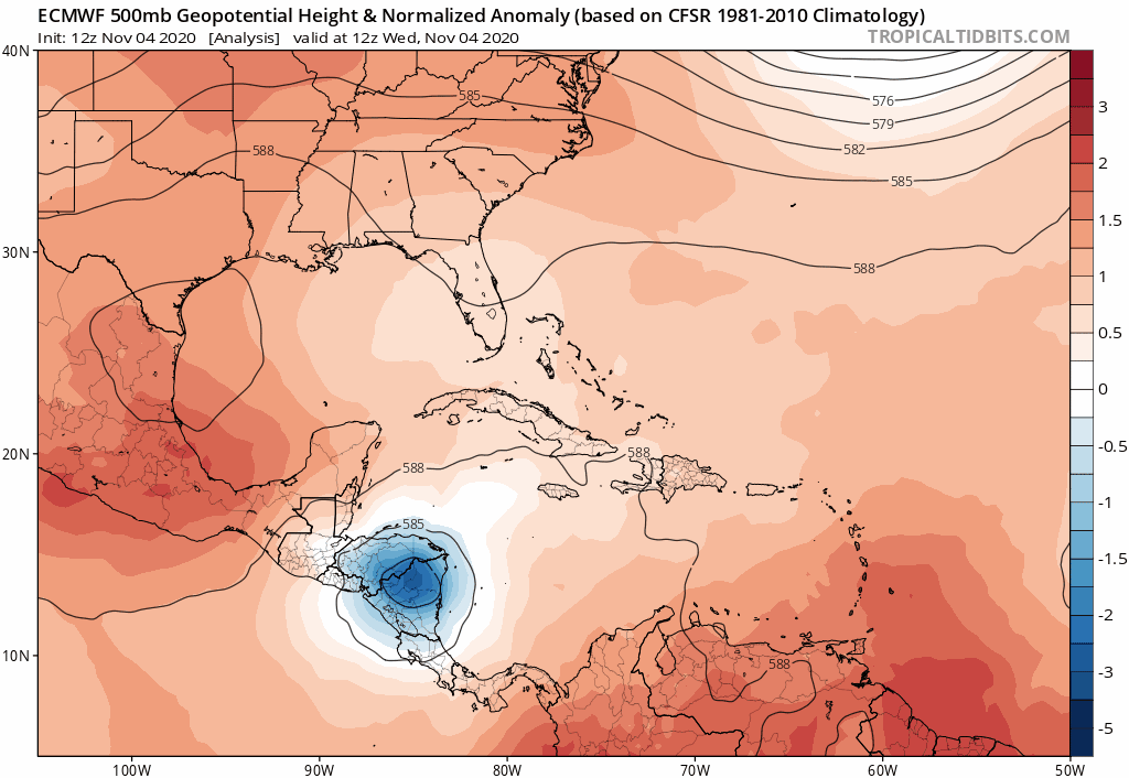
TheStormExpert
Re: ATL: ETA - Models
gatorcane wrote:The Florida High appears at the right time again to turn this
https://i.postimg.cc/VkXcLb1V/ecmwf-z500a-Norm-watl-fh0-144.gif
Our friend the SE ridge! Keeps our winters warm and humid while also protecting us from tropical cyclone threats.
0 likes

-
SFLcane
- S2K Supporter
- Posts: 10281
- Age: 48
- Joined: Sat Jun 05, 2010 1:44 pm
- Location: Lake Worth Florida
Re: ATL: ETA - Models
CourierPR wrote:You folks need to get off this Florida high kick.
Lol it’s at every opportunity to defend that Florida shield. I highly doupt Florida gets out of this one with some sort of impact. A TS is NOT a point on a map effects can extend ways away from any center.
0 likes
Re: ATL: ETA - Models
Folks, the 12Z Euro says we'll have Kate the 2nd: keep in mind that the letters eta are all in the name Kate 

Last edited by LarryWx on Wed Nov 04, 2020 1:50 pm, edited 2 times in total.
3 likes
Personal Forecast Disclaimer:
The posts in this forum are NOT official forecasts and should not be used as such. They are just the opinion of the poster and may or may not be backed by sound meteorological data. They are NOT endorsed by any professional institution or storm2k.org. For official information, please refer to the NHC and NWS products.
The posts in this forum are NOT official forecasts and should not be used as such. They are just the opinion of the poster and may or may not be backed by sound meteorological data. They are NOT endorsed by any professional institution or storm2k.org. For official information, please refer to the NHC and NWS products.
-
jaxfladude
- Category 5
- Posts: 1249
- Joined: Wed Aug 24, 2005 9:36 pm
- Location: Jacksonville, Fla
Re: ATL: ETA - Models
Do I in NE FLORIDA need to watch with any concerns ie ETA? Rains heavy? Or chance of some flooding like Fay Debbie(?) Or even Hurricane conditions at long shot?
0 likes
Stay safe y'all
Who is online
Users browsing this forum: No registered users and 28 guests