Edit: landfalls near Palm Beach at 979mb at 120 hours
ATL: ETA - Models
Moderator: S2k Moderators
-
gatorcane

- S2K Supporter

- Posts: 23708
- Age: 48
- Joined: Sun Mar 13, 2005 3:54 pm
- Location: Boca Raton, FL
Re: ATL: ETA - Models
18Z ICON is 16mb stronger and more SW than 12Z by hour 102 in the Bahamas. Basically has a hurricane.
Edit: landfalls near Palm Beach at 979mb at 120 hours
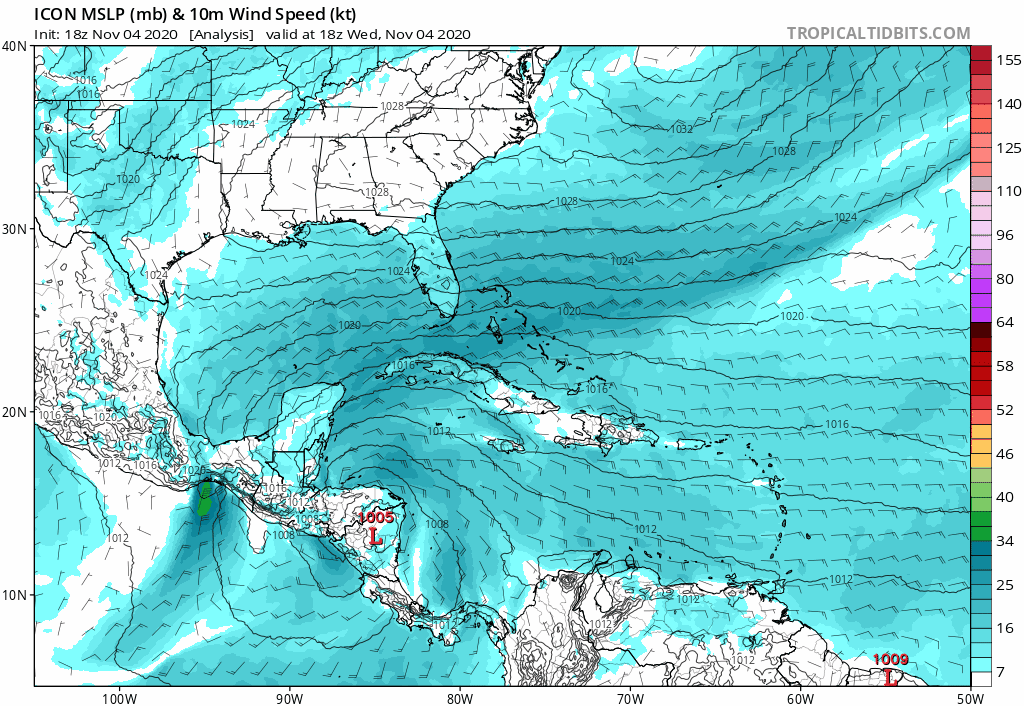
Edit: landfalls near Palm Beach at 979mb at 120 hours
0 likes

Re: ATL: ETA - Models
I’m still going out on a limb and saying NE Florida—>South Carolina for a landfall point. I feel like I’m seeing more runs with east coast hook backs and they keep ending further up to the north... regardless of the model I’m not playing favorites here just noticing the outlier trends
0 likes
-
AutoPenalti
- Category 5

- Posts: 4091
- Age: 29
- Joined: Mon Aug 17, 2015 4:16 pm
- Location: Ft. Lauderdale, Florida
Re: ATL: ETA - Models
gatorcane wrote:18Z ICON is 16mb stronger and more SW than 12Z by hour 102 in the Bahamas. Basically has a hurricane.
Edit: landfalls near Palm Beach at 979mb at 120 hours
https://i.postimg.cc/gJvj59VB/icon-mslp-wind-watl-fh0-114.gif
Low end Cat 1 honestly.
0 likes
The posts in this forum are NOT official forecasts and should not be used as such. They are just the opinion of the poster and may or may not be backed by sound meteorological data. They are NOT endorsed by any professional institution or STORM2K. For official information, please refer to products from the NHC and NWS.
Model Runs Cheat Sheet:
GFS (5:30 AM/PM, 11:30 AM/PM)
HWRF, GFDL, UKMET, NAVGEM (6:30-8:00 AM/PM, 12:30-2:00 AM/PM)
ECMWF (1:45 AM/PM)
TCVN is a weighted averaged

Re: ATL: ETA - Models
12z Euro sticking to its track and gets ETA down to 970 mb in the GOM.
0 likes
-
TheStormExpert
Re: ATL: ETA - Models
GeneratorPower wrote:Haven’t been here for a while. Let me guess. Louisiana.
Surprisingly no. Though the 12z Euro has it just SE of it this time next week.
0 likes
-
Blown Away

- S2K Supporter
- Posts: 10253
- Joined: Wed May 26, 2004 6:17 am
Re: ATL: ETA - Models
AutoPenalti wrote:gatorcane wrote:18Z ICON is 16mb stronger and more SW than 12Z by hour 102 in the Bahamas. Basically has a hurricane.
Edit: landfalls near Palm Beach at 979mb at 120 hours
https://i.postimg.cc/gJvj59VB/icon-mslp-wind-watl-fh0-114.gif
Low end Cat 1 honestly.

1 likes
Hurricane Eye Experience: David 79, Irene 99, Frances 04, Jeanne 04, Wilma 05… Hurricane Brush Experience: Andrew 92, Erin 95, Floyd 99, Matthew 16, Irma 17, Ian 22, Nicole 22…
-
AutoPenalti
- Category 5
- Posts: 4091
- Age: 29
- Joined: Mon Aug 17, 2015 4:16 pm
- Location: Ft. Lauderdale, Florida
Re: ATL: ETA - Models
Blown Away wrote:AutoPenalti wrote:gatorcane wrote:18Z ICON is 16mb stronger and more SW than 12Z by hour 102 in the Bahamas. Basically has a hurricane.
Edit: landfalls near Palm Beach at 979mb at 120 hours
https://i.postimg.cc/gJvj59VB/icon-mslp-wind-watl-fh0-114.gif
Low end Cat 1 honestly.
https://i.imgur.com/FO3Qs5u.jpg
Pressures sometimes don't correlate with wind speeds.
0 likes
The posts in this forum are NOT official forecasts and should not be used as such. They are just the opinion of the poster and may or may not be backed by sound meteorological data. They are NOT endorsed by any professional institution or STORM2K. For official information, please refer to products from the NHC and NWS.
Model Runs Cheat Sheet:
GFS (5:30 AM/PM, 11:30 AM/PM)
HWRF, GFDL, UKMET, NAVGEM (6:30-8:00 AM/PM, 12:30-2:00 AM/PM)
ECMWF (1:45 AM/PM)
TCVN is a weighted averaged
-
Blown Away
- S2K Supporter
- Posts: 10253
- Joined: Wed May 26, 2004 6:17 am
Re: ATL: ETA - Models
AutoPenalti wrote:
Pressures sometimes don't correlate with wind speeds.
Agree, but this scale gives a good baseline.
0 likes
Hurricane Eye Experience: David 79, Irene 99, Frances 04, Jeanne 04, Wilma 05… Hurricane Brush Experience: Andrew 92, Erin 95, Floyd 99, Matthew 16, Irma 17, Ian 22, Nicole 22…
-
SFLcane

- S2K Supporter
- Posts: 10281
- Age: 48
- Joined: Sat Jun 05, 2010 1:44 pm
- Location: Lake Worth Florida
Re: ATL: ETA - Models
gatorcane wrote:18Z ICON is 16mb stronger and more SW than 12Z by hour 102 in the Bahamas. Basically has a hurricane.
Edit: landfalls near Palm Beach at 979mb at 120 hours
https://i.postimg.cc/gJvj59VB/icon-mslp-wind-watl-fh0-114.gif
0 likes
-
TheProfessor

- Professional-Met

- Posts: 3506
- Age: 29
- Joined: Tue Dec 03, 2013 10:56 am
- Location: Wichita, Kansas
Re: ATL: ETA - Models
Blown Away wrote:AutoPenalti wrote:gatorcane wrote:18Z ICON is 16mb stronger and more SW than 12Z by hour 102 in the Bahamas. Basically has a hurricane.
Edit: landfalls near Palm Beach at 979mb at 120 hours
https://i.postimg.cc/gJvj59VB/icon-mslp-wind-watl-fh0-114.gif
Low end Cat 1 honestly.
https://i.imgur.com/FO3Qs5u.jpg
There's a reason why pressure is no longer on the the Saffir Simpson scale. Although a 979mb storm the size of what the ICON shows would likely result in a strong Cat-1 weak Cat-2, due to the extensive land interaction and interaction with a trough the storm is likely going to end up on the larger side so a weak to midgrade Cat-1 is possible with that pressure in that scenario. The ICON is likely way too small with the storm.
0 likes
An alumnus of The Ohio State University.
Your local National Weather Service office is your best source for weather information.
Your local National Weather Service office is your best source for weather information.

Re: ATL: ETA - Models
AutoPenalti wrote:
Pressures sometimes don't correlate with wind speeds.
Good point.....that perspective could then be applied to suggest a possible "low end" Cat 3 then. I think it's quite premature to say, especially given that we're yet to determine if this will be subtropical or fully tropical.
0 likes
Andy D
(For official information, please refer to the NHC and NWS products.)
(For official information, please refer to the NHC and NWS products.)
-
AutoPenalti
- Category 5
- Posts: 4091
- Age: 29
- Joined: Mon Aug 17, 2015 4:16 pm
- Location: Ft. Lauderdale, Florida
Re: ATL: ETA - Models
chaser1 wrote:AutoPenalti wrote:Blown Away wrote:https://i.imgur.com/FO3Qs5u.jpg
Pressures sometimes don't correlate with wind speeds.
Good point.....that perspective could then be applied to suggest a possible "low end" Cat 3 then. I think it's quite premature to say, especially given that we're yet to determine if this will be subtropical or fully tropical.
Which is why sometimes the GFS and Euro shouldn’t be used as intensity forecasts considering its low grid resolution. I’m glad the HWRF has been excelling this year, it seriously impressed when needed.
2 likes
The posts in this forum are NOT official forecasts and should not be used as such. They are just the opinion of the poster and may or may not be backed by sound meteorological data. They are NOT endorsed by any professional institution or STORM2K. For official information, please refer to products from the NHC and NWS.
Model Runs Cheat Sheet:
GFS (5:30 AM/PM, 11:30 AM/PM)
HWRF, GFDL, UKMET, NAVGEM (6:30-8:00 AM/PM, 12:30-2:00 AM/PM)
ECMWF (1:45 AM/PM)
TCVN is a weighted averaged
-
SFLcane
- S2K Supporter
- Posts: 10281
- Age: 48
- Joined: Sat Jun 05, 2010 1:44 pm
- Location: Lake Worth Florida
Re: ATL: ETA - Models
Wow gfs 979mb really? SFL on dirty side
Last edited by SFLcane on Wed Nov 04, 2020 5:20 pm, edited 1 time in total.
0 likes

Re: ATL: ETA - Models
18z Happy Hour gets this trapped in the Florida Straits and makes landfall in SFL/the Keys as a Cat1.
1 likes
Irene '11 Sandy '12 Hermine '16 5/15/2018 Derecho Fay '20 Isaias '20 Elsa '21 Henri '21 Ida '21
I am only a meteorology enthusiast who knows a decent amount about tropical cyclones. Look to the professional mets, the NHC, or your local weather office for the best information.
I am only a meteorology enthusiast who knows a decent amount about tropical cyclones. Look to the professional mets, the NHC, or your local weather office for the best information.
-
SFLcane
- S2K Supporter
- Posts: 10281
- Age: 48
- Joined: Sat Jun 05, 2010 1:44 pm
- Location: Lake Worth Florida
Re: ATL: ETA - Models
Today’s trends are interesting SFL might have to prepare for a minimal hurricane.
0 likes
Re: ATL: ETA - Models
Also note that if this is a more hybrid system, the winfield will probably be more extensive.
0 likes
-
Iceresistance

- Category 5
- Posts: 9579
- Age: 22
- Joined: Sat Oct 10, 2020 9:45 am
- Location: Tecumseh, OK/Norman, OK
Re: ATL: ETA - Models
GFS reaggressive with Eta, powerful & extemely dangerous hurricane that is meandering all around the Caribbean
0 likes
Bill 2015 & Beta 2020
Winter 2020-2021
All observations are in Tecumseh, OK unless otherwise noted.
Winter posts are focused mainly for Oklahoma & Texas.
Take any of my forecasts with a grain of salt, refer to the NWS, SPC, and NHC for official information
Never say Never with weather! Because ANYTHING is possible!
Winter 2020-2021
All observations are in Tecumseh, OK unless otherwise noted.
Winter posts are focused mainly for Oklahoma & Texas.
Take any of my forecasts with a grain of salt, refer to the NWS, SPC, and NHC for official information
Never say Never with weather! Because ANYTHING is possible!
-
Blown Away
- S2K Supporter
- Posts: 10253
- Joined: Wed May 26, 2004 6:17 am
Re: ATL: ETA - Models

18z GFS "Happy Hour" didn't disappoint... Wow, one crazy ride from Honduras to Florida Keys then all the way to Veracruz Mexico...
5 likes
Hurricane Eye Experience: David 79, Irene 99, Frances 04, Jeanne 04, Wilma 05… Hurricane Brush Experience: Andrew 92, Erin 95, Floyd 99, Matthew 16, Irma 17, Ian 22, Nicole 22…
-
toad strangler

- S2K Supporter
- Posts: 4546
- Joined: Sun Jul 28, 2013 3:09 pm
- Location: Earth
- Contact:
Re: ATL: ETA - Models
18z GEFS
This could be legit trouble for any terra firma near where it decides to meander around

This could be legit trouble for any terra firma near where it decides to meander around
0 likes
My Weather Station
https://www.wunderground.com/dashboard/pws/KFLPORTS603
https://www.wunderground.com/dashboard/pws/KFLPORTS603
-
toad strangler
- S2K Supporter
- Posts: 4546
- Joined: Sun Jul 28, 2013 3:09 pm
- Location: Earth
- Contact:
Re: ATL: ETA - Models
And then it looks like the 18z GEFS went drinking with the OP tonight as most are stumbling west with it in the longer range 

0 likes
My Weather Station
https://www.wunderground.com/dashboard/pws/KFLPORTS603
https://www.wunderground.com/dashboard/pws/KFLPORTS603
Who is online
Users browsing this forum: No registered users and 13 guests