ATL: ETA - Models

Moderator: S2k Moderators

Message
Author
User avatar
eastcoastFL
Category 5
Category 5
Posts: 3901
Age: 43
Joined: Thu Apr 12, 2007 12:29 pm
Location: Palm City, FL

Re: ATL: ETA - Models

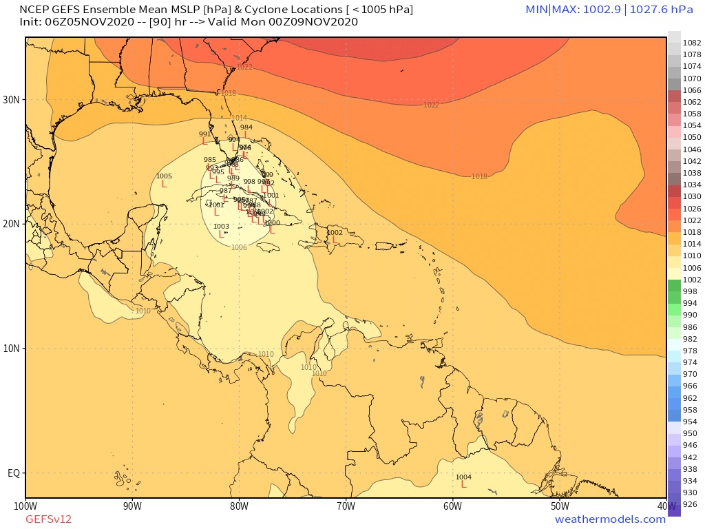
#1121 Postby eastcoastFL » Thu Nov 05, 2020 1:33 am

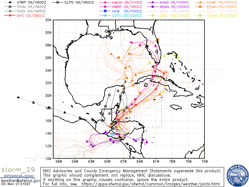
HWRF with a TS into SFL Sunday

Image


Heads NE into the Bahamas

Image

Then strengthens and moves back west into Vero/Melbourne. What a wild set up. This all takes place Sunday to Monday so HWRF seems to be much faster and east than the NHC


Image


One thing this model is good at is predicting the structure and it appears to show a very lopsided storm with everything to the North and East.
1 likes   
Personal Forecast Disclaimer:
The posts in this forum are NOT official forecast and should not be used as such. They are just the opinion of the poster and may or may not be backed by sound meteorological data. They are NOT endorsed by any professional institution or storm2k.org. For official information, please refer to the NHC and NWS products.

LarryWx
S2K Supporter
S2K Supporter
Posts: 6305
Joined: Sun Sep 07, 2003 2:04 pm
Location: GA

Re: ATL: ETA - Models

#1122 Postby LarryWx » Thu Nov 05, 2020 5:55 am

6z GEFS: :eek: :eek:

Image
2 likes   
Personal Forecast Disclaimer:
The posts in this forum are NOT official forecasts and should not be used as such. They are just the opinion of the poster and may or may not be backed by sound meteorological data. They are NOT endorsed by any professional institution or storm2k.org. For official information, please refer to the NHC and NWS products.

User avatar
N2FSU
S2K Supporter
S2K Supporter
Posts: 1062
Joined: Thu Sep 04, 2003 2:04 pm
Location: Tallahassee, FL

Re: ATL: ETA - Models

#1123 Postby N2FSU » Thu Nov 05, 2020 5:58 am

6z GFS; Cat 2/3 into my neck of the woods Image


Sent from my iPhone using Tapatalk
0 likes   

xironman
S2K Supporter
S2K Supporter
Posts: 2522
Joined: Sun Jun 10, 2007 4:53 pm
Location: NoVA

Re: ATL: ETA - Models

#1124 Postby xironman » Thu Nov 05, 2020 6:14 am

Another case of baroclinic enhancement on final approach? The GFS has been doing fairly well at 500mb.

Image
0 likes   

User avatar
SFLcane
S2K Supporter
S2K Supporter
Posts: 10163
Age: 47
Joined: Sat Jun 05, 2010 1:44 pm
Location: Lake Worth Florida

Re: ATL: ETA - Models

#1125 Postby SFLcane » Thu Nov 05, 2020 6:38 am

06z Hwrf intensifies This rather quickly in the nw Caribbean brining it to a hurricane and then into south Florida 982 mb
2 likes   

TheStormExpert

Re: ATL: ETA - Models

#1126 Postby TheStormExpert » Thu Nov 05, 2020 6:53 am

SFLcane wrote:06z Hwrf intensifies This rather quickly in the nw Caribbean brining it to a hurricane and then into south Florida 982 mb

Seems to be the only model that brings it to South Florida, as others such as the GFS and Euro remain south of the state.

Still thinking rain will be the main issue here in South Florida.
0 likes   

User avatar
SFLcane
S2K Supporter
S2K Supporter
Posts: 10163
Age: 47
Joined: Sat Jun 05, 2010 1:44 pm
Location: Lake Worth Florida

Re: ATL: ETA - Models

#1127 Postby SFLcane » Thu Nov 05, 2020 7:01 am

TheStormExpert wrote:
SFLcane wrote:06z Hwrf intensifies This rather quickly in the nw Caribbean brining it to a hurricane and then into south Florida 982 mb

Seems to be the only model that brings it to South Florida, as others such as the GFS and Euro remain south of the state.

Still thinking rain will be the main issue here in South Florida.


06z Hmon has a 987mb system into Broward.
0 likes   

TheStormExpert

Re: ATL: ETA - Models

#1128 Postby TheStormExpert » Thu Nov 05, 2020 7:02 am

SFLcane wrote:
TheStormExpert wrote:
SFLcane wrote:06z Hwrf intensifies This rather quickly in the nw Caribbean brining it to a hurricane and then into south Florida 982 mb

Seems to be the only model that brings it to South Florida, as others such as the GFS and Euro remain south of the state.

Still thinking rain will be the main issue here in South Florida.


06z Hmon has a 987mb system into Broward.

Besides the hurricane models which are no good without an actual LLC.
0 likes   

User avatar
gatorcane
S2K Supporter
S2K Supporter
Posts: 23691
Age: 47
Joined: Sun Mar 13, 2005 3:54 pm
Location: Boca Raton, FL

Re: ATL: ETA - Models

#1129 Postby gatorcane » Thu Nov 05, 2020 7:21 am

Models trending more towards a turn west into the Gulf before reaching South Florida as the SE ridge flexes its muscle again.

Image

Image
Image
Last edited by gatorcane on Thu Nov 05, 2020 7:25 am, edited 1 time in total.
2 likes   

TheStormExpert

Re: ATL: ETA - Models

#1130 Postby TheStormExpert » Thu Nov 05, 2020 7:24 am

gatorcane wrote:Models trending more towards a turn west into the Gulf before reaching South Florida as the SE ridge flexes its muscle again.

https://i.postimg.cc/wxfskc0K/storm-29-ens.gif

If that's the case then this may never reach South Florida. That SE Ridge has been a semi-permanent feature over the past many months.
0 likes   

jlauderdal
S2K Supporter
S2K Supporter
Posts: 7182
Joined: Wed May 19, 2004 5:46 am
Location: NE Fort Lauderdale
Contact:

Re: ATL: ETA - Models

#1131 Postby jlauderdal » Thu Nov 05, 2020 7:31 am

TheStormExpert wrote:
gatorcane wrote:Models trending more towards a turn west into the Gulf before reaching South Florida as the SE ridge flexes its muscle again.

https://i.postimg.cc/wxfskc0K/storm-29-ens.gif

If that's the case then this may never reach South Florida. That SE Ridge has been a semi-permanent feature over the past many months.


actually worse for south Florida in terms of flooding if it stays south and west.which was always going to be the big issue...just had our first downpour of this 6+ day rain event that starts today

The ground is very saturated from a few weeks of heavy rain so this is going to be big trouble for an area that can typically take on big totals
0 likes   

User avatar
gatorcane
S2K Supporter
S2K Supporter
Posts: 23691
Age: 47
Joined: Sun Mar 13, 2005 3:54 pm
Location: Boca Raton, FL

Re: ATL: ETA - Models

#1132 Postby gatorcane » Thu Nov 05, 2020 7:44 am

Highly sheared according the the GFS:

Image
0 likes   

User avatar
SFLcane
S2K Supporter
S2K Supporter
Posts: 10163
Age: 47
Joined: Sat Jun 05, 2010 1:44 pm
Location: Lake Worth Florida

Re: ATL: ETA - Models

#1133 Postby SFLcane » Thu Nov 05, 2020 7:46 am

Once low pressure forms tonight or tomorrow we will have a much better idea on what we might expect here in Florida.
2 likes   

TheStormExpert

Re: ATL: ETA - Models

#1134 Postby TheStormExpert » Thu Nov 05, 2020 7:47 am

jlauderdal wrote:
TheStormExpert wrote:
gatorcane wrote:Models trending more towards a turn west into the Gulf before reaching South Florida as the SE ridge flexes its muscle again.

https://i.postimg.cc/wxfskc0K/storm-29-ens.gif

If that's the case then this may never reach South Florida. That SE Ridge has been a semi-permanent feature over the past many months.


actually worse for south Florida in terms of flooding if it stays south and west.which was always going to be the big issue...just had our first downpour of this 6+ day rain event that starts today

The ground is very saturated from a few weeks of heavy rain so this is going to be big trouble for an area that can typically take on big totals

Well wind obviously won't be a huge issue. But we definitely don't need the rain. :roll:
0 likes   

User avatar
SFLcane
S2K Supporter
S2K Supporter
Posts: 10163
Age: 47
Joined: Sat Jun 05, 2010 1:44 pm
Location: Lake Worth Florida

Re: ATL: ETA - Models

#1135 Postby SFLcane » Thu Nov 05, 2020 7:47 am

gatorcane wrote:Highly sheared according the the GFS:

https://i.postimg.cc/8C0DXHX3/gfs-ir-watl-fh1-115-3.gif


Sheared or not impacts will be felt across the peninsula. Still early to be banking in any models
3 likes   

TheStormExpert

Re: ATL: ETA - Models

#1136 Postby TheStormExpert » Thu Nov 05, 2020 7:48 am

gatorcane wrote:Highly sheared according the the GFS:

https://i.postimg.cc/8C0DXHX3/gfs-ir-watl-fh1-115-3.gif

The 00z GFS showing better UL conditions in The Bahamas must've been a fluke.
0 likes   

User avatar
SFLcane
S2K Supporter
S2K Supporter
Posts: 10163
Age: 47
Joined: Sat Jun 05, 2010 1:44 pm
Location: Lake Worth Florida

Re: ATL: ETA - Models

#1137 Postby SFLcane » Thu Nov 05, 2020 7:51 am

TheStormExpert wrote:
jlauderdal wrote:
TheStormExpert wrote:If that's the case then this may never reach South Florida. That SE Ridge has been a semi-permanent feature over the past many months.


actually worse for south Florida in terms of flooding if it stays south and west.which was always going to be the big issue...just had our first downpour of this 6+ day rain event that starts today

The ground is very saturated from a few weeks of heavy rain so this is going to be big trouble for an area that can typically take on big totals

Well wind obviously won't be a huge issue. But we definitely don't need the rain. :roll:


Based on One set of models runs? Impacts to the peninsula still are highly unknown.
6 likes   

User avatar
boca
Category 5
Category 5
Posts: 6367
Age: 60
Joined: Mon Dec 15, 2003 8:49 am
Location: Boca Raton,FL

Re: ATL: ETA - Models

#1138 Postby boca » Thu Nov 05, 2020 7:53 am

If the models are using Eta the circulation is almost in the Pacific so I saw this area WSW of Jamaica this morning look interesting. I wonder if the system that’s forecast to develop in the Gulf of Honduras is something else the models are picking up.
3 likes   

Nuno
Category 2
Category 2
Posts: 597
Joined: Fri Aug 30, 2019 8:35 am
Location: Coral Gables, FL

Re: ATL: ETA - Models

#1139 Postby Nuno » Thu Nov 05, 2020 7:54 am

jlauderdal wrote:
TheStormExpert wrote:
gatorcane wrote:Models trending more towards a turn west into the Gulf before reaching South Florida as the SE ridge flexes its muscle again.

https://i.postimg.cc/wxfskc0K/storm-29-ens.gif

If that's the case then this may never reach South Florida. That SE Ridge has been a semi-permanent feature over the past many months.


actually worse for south Florida in terms of flooding if it stays south and west.which was always going to be the big issue...just had our first downpour of this 6+ day rain event that starts today

The ground is very saturated from a few weeks of heavy rain so this is going to be big trouble for an area that can typically take on big totals


I already lost power for 20 mins. I'm going to hate this weekend.
0 likes   
Andrew (1992), Irene (1999), Frances (2004), Katrina (2005), Wilma (2005), Fay (2008), Irma (2017), Eta (2020), Ian (2022)

User avatar
SFLcane
S2K Supporter
S2K Supporter
Posts: 10163
Age: 47
Joined: Sat Jun 05, 2010 1:44 pm
Location: Lake Worth Florida

Re: ATL: ETA - Models

#1140 Postby SFLcane » Thu Nov 05, 2020 8:03 am

06z GEFS ensembles..

Image
0 likes   


Return to “2020”

Who is online

Users browsing this forum: No registered users and 4 guests