ATL: ETA - Post-Tropical - Discussion
Moderator: S2k Moderators
-
gatorcane

- S2K Supporter

- Posts: 23708
- Age: 48
- Joined: Sun Mar 13, 2005 3:54 pm
- Location: Boca Raton, FL
Re: ATL: ETA - Tropical Depression - Discussion
Better start turning north soon or it might end up in the EPAC like I see some of the 00Z guidance taking this:
2 likes

Re: ATL: ETA - Tropical Depression - Discussion
It’ll be kinda funny if Eta or parts of Eta become a new system in the EPac — like the NAtl has waited so long for the EPac to respond to its “Marco” that it just makes “Polo” itself.
4 likes
Irene '11 Sandy '12 Hermine '16 5/15/2018 Derecho Fay '20 Isaias '20 Elsa '21 Henri '21 Ida '21
I am only a meteorology enthusiast who knows a decent amount about tropical cyclones. Look to the professional mets, the NHC, or your local weather office for the best information.
I am only a meteorology enthusiast who knows a decent amount about tropical cyclones. Look to the professional mets, the NHC, or your local weather office for the best information.
-
TexasBreeze
- Tropical Depression

- Posts: 81
- Joined: Mon Jul 07, 2014 12:50 pm
Re: ATL: ETA - Tropical Depression - Discussion
Looks to me like it is well on its way to becoming an Epac system soon. Could be so weak that the mid level low follows the mean flow west, but some moisture or piece may be pulled north at some point.
1 likes
-
toad strangler

- S2K Supporter
- Posts: 4546
- Joined: Sun Jul 28, 2013 3:09 pm
- Location: Earth
- Contact:
Re: ATL: ETA - Tropical Depression - Discussion
gatorcane wrote:Better start turning north soon or it might end up in the EPAC like I see some of the 00Z guidance taking this:
https://i.postimg.cc/rF1y5d56/920449-A4-0-F6-D-4-C57-BC9-A-779-E26-F19-DB0.gif
Nah, I don't think anyone expects that whole mess to turn north. THere is energy lagging behind in the Caribbean that will obviously be the catalyst to whatever ends up moving N and NE.
1 likes
My Weather Station
https://www.wunderground.com/dashboard/pws/KFLPORTS603
https://www.wunderground.com/dashboard/pws/KFLPORTS603

-
MJGarrison
- Tropical Storm

- Posts: 146
- Joined: Wed Aug 30, 2017 7:26 pm
Re: ATL: ETA - Tropical Depression - Discussion
I was busy like everyone last night and didn’t watch Levi’s video until tonight. He did mention at the beginning that the MLC would continue west even though the storm was expected to reform to the North.
Sent from my iPhone using Tapatalk
Sent from my iPhone using Tapatalk
0 likes
-
TheStormExpert
Re: ATL: ETA - Tropical Depression - Discussion
gatorcane wrote:Better start turning north soon or it might end up in the EPAC like I see some of the 00Z guidance taking this:
https://i.postimg.cc/rF1y5d56/920449-A4-0-F6-D-4-C57-BC9-A-779-E26-F19-DB0.gif
Looks like a big CAG now.
0 likes
-
Spacecoast

- Category 2

- Posts: 773
- Joined: Thu Aug 31, 2017 2:03 pm

-
TheStormExpert
Re: ATL: ETA - Tropical Depression - Discussion
As if the 20 inches of rain we've received last month wasn't enough! 

Hydrologic Outlook
National Weather Service Miami FL
405 PM EST Wed Nov 4 2020
...VERY HEAVY RAINFALL POSSIBLE THIS WEEKEND INTO EARLY NEXT WEEK
ACROSS SOUTH FLORIDA...
NHC is forecasting Tropical Cyclone Eta to move across Honduras
tonight into Thursday before moving back into the Northwest Caribbean
Sea by end of this week. NHC is then forecasting the system to move
into the Florida Straits over the Southeastern Gulf of Mexico this
weekend into early next week. The long range models are also showing
the frontal Boundary over the Florida Straits to move northward
back into South Florida this weekend, as a trough of low pressure
develops over the Gulf of Mexico. This will allow for deep
tropical moisture to work into South Florida from the Caribbean
Sea this weekend into early next week where the PWAT values are in
the 2.1 to 2.4 inch range. These PWAT values are at the maximum
PWAT values for this time of year. This means that showers and
thunderstorms that do develop will be capable of producing very
heavy rainfall this weekend into early next week.
Forecast rainfall totals from Thursday night through early next
week looks to be between 10 to 15 inches over the east coast
metro areas tapering down to 4 to 8 inches over the western areas
of South Florida. There could also be locally higher amounts with
any showers or thunderstorms that do train over the same area.
It should be stated that these amounts could easily change
with future forecast adjustments. But the key message is that a
potentially impactful flooding event is possible for the eastern
metro areas should these trends hold. A Flood Watch may be required
for some portion of our area with future forecast updates.
0 likes
-
ElectricStorm

- Category 5

- Posts: 5124
- Age: 24
- Joined: Tue Aug 13, 2019 11:23 pm
- Location: Norman, OK
Re: ATL: ETA - Tropical Depression - Discussion
Eta should be downgraded to a remnant low pretty soon and that will begin the entire regeneration process. We'll have to watch what the NHC does, if they at some point call it 97L, then it will be Theta, if not, it will likely stay Eta I would think. Either way, usually the NHC stops advisories whenever they downgrade to remnant low, but would they keep going with the advisories here since they already have an intensifying TS nearing FL? I know they haven't done that in the past with storms like Harvey, but it will be interesting to see what they do here.
2 likes
B.S Meteorology, University of Oklahoma '25
Please refer to the NHC, NWS, or SPC for official information.
Please refer to the NHC, NWS, or SPC for official information.
-
jaxfladude
- Category 5
- Posts: 1249
- Joined: Wed Aug 24, 2005 9:36 pm
- Location: Jacksonville, Fla
Re: ATL: ETA - Tropical Depression - Discussion
Any update from the areas that got impacted by ETA how bad was it for them or still ongoing/too soon to known with certainty?
0 likes
Stay safe y'all
-
bob rulz
- Category 5
- Posts: 1711
- Age: 35
- Joined: Sat Jan 28, 2006 7:30 pm
- Location: Salt Lake City, Utah
Re: ATL: ETA - Tropical Depression - Discussion
jaxfladude wrote:Any update from the areas that got impacted by ETA how bad was it for them or still ongoing/too soon to known with certainty?
I think it's just too early. Most recent update I see says 3 dead, but sadly I just don't see how the death toll won't climb much higher once communication is restored and the area becomes more accessible.
0 likes
-
crownweather

- S2K Supporter
- Posts: 602
- Age: 51
- Joined: Sat Aug 12, 2006 9:21 am
- Location: Sturbridge, Massachusetts
- Contact:
Re: ATL: ETA - Tropical Depression - Discussion
Crazy to see how quiet this board is given the potential for Eta or some part of Eta to strengthen again & be at least a tropical storm threat to the FL Keys and South Florida by early next week. Goes to show how busy and downright exhausting this season has been for all of us. In any other season, this board would be hopping even at this early time of the morning.
5 likes
Rob Lightbown
Crown Weather Services
https://crownweather.com
Crown Weather Services
https://crownweather.com

Re: ATL: ETA - Tropical Depression - Discussion
Watching it closely up here in TLH, although things will change a million times before any possible impacts up here. Not liking the intensity trends however. 
Sent from my iPhone using Tapatalk
Sent from my iPhone using Tapatalk
3 likes
-
SouthernBreeze

- Category 1

- Posts: 284
- Age: 69
- Joined: Tue Aug 31, 2004 4:54 pm
- Location: SC/NC line- on the SC Coast
Re: ATL: ETA - Tropical Depression - Discussion
Ptarmigan wrote:Are there any reports out of Central America. It has been lingering over Central America.
A little info here -
https://www.accuweather.com/en/hurricane/at-least-4-killed-after-hurricane-eta-blasts-central-america-as-cat-4-storm/842849
0 likes
My posts are NOT official forecast and should not be used as such. It's just my opinion and not backed by sound meteorological data, and NOT endorsed by any professional institution or storm2k.org. For official information, please refer to the NHC and NWS products.
grazed by many - most wind damage: Hugo (pre-cellphone days!) & most water: Floyd
grazed by many - most wind damage: Hugo (pre-cellphone days!) & most water: Floyd

Re: ATL: ETA - Tropical Depression - Discussion
crownweather wrote:Crazy to see how quiet this board is given the potential for Eta or some part of Eta to strengthen again & be at least a tropical storm threat to the FL Keys and South Florida by early next week. Goes to show how busy and downright exhausting this season has been for all of us. In any other season, this board would be hopping even at this early time of the morning.
Consumed by Arizona, Georgia and Pennsylvania vote totals!
2 likes
Personal Forecast Disclaimer:
My posts are just my opinion and are most likely not backed by sound meteorological data. They are NOT endorsed by any professional institution or storm2k.org. For official information, please refer to the NHC and NWS products.
Bottom line is that I am just expressing my opinion!!!
My posts are just my opinion and are most likely not backed by sound meteorological data. They are NOT endorsed by any professional institution or storm2k.org. For official information, please refer to the NHC and NWS products.
Bottom line is that I am just expressing my opinion!!!

Re: ATL: ETA - Tropical Depression - Discussion
crownweather wrote:Crazy to see how quiet this board is given the potential for Eta or some part of Eta to strengthen again & be at least a tropical storm threat to the FL Keys and South Florida by early next week. Goes to show how busy and downright exhausting this season has been for all of us. In any other season, this board would be hopping even at this early time of the morning.
The board does tend to slow down late in the season and I think many are tired from tracking so many storms. Also the election might be gathering a lot of attention.
I can tell you that most in the Florida Keys are not concerned about Eta. Since it is only forecast to be a tropical storm, many equate that do the same weather we get with a strong cold front. That said, I think it will catch many Conchs by surprise.
This weekend when Eta is likely to regain storm status, this board will start to come alive again and may even go back to hyperactive when hurricane watches are issued.(if necessary)
Watching the model trends, I will be surprised if this does not become a hurricane as it approaches Cuba and Florida.
Last edited by Jr0d on Thu Nov 05, 2020 6:41 am, edited 1 time in total.
2 likes
Re: ATL: ETA - Tropical Depression - Discussion
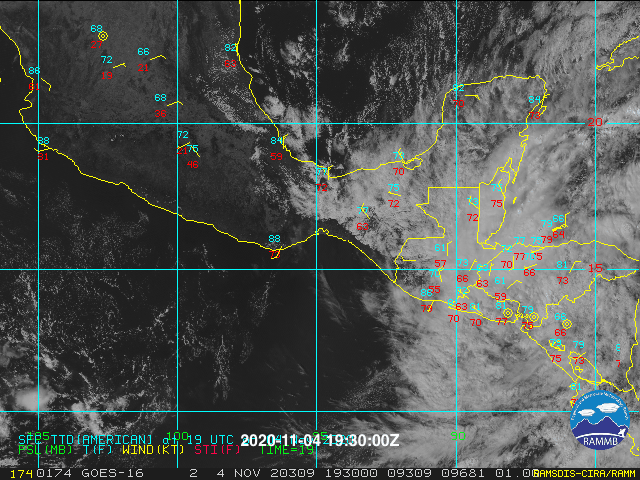
It looks like the system is so degraded near El Salvador and whatever goes on in the GOH so disconnected from the circulation they should give it a new name. Not to mention that Theta is an awesome name for a storm.

2 likes
Re: ATL: ETA - Tropical Depression - Discussion
xironman wrote:It looks like the system is so degraded near El Salvador and whatever goes on in the GOH so disconnected from the circulation they should give it a new name. Not to mention that Theta is an awesome name for a storm.
https://i.imgur.com/13s6DyW.gif
I agree. The circulation is clearly about to emerge in the Pacific.
Late tonight or tomorrow is when the models are showing a low form in the Gulf of Hondorus. I am not sure what the NHC will do.
0 likes
-
Weatherboy1

- Category 5
- Posts: 1190
- Age: 50
- Joined: Mon Jul 05, 2004 1:50 pm
- Location: Jupiter/Sarasota, FL
Re: ATL: ETA - Tropical Depression - Discussion
Jr0d wrote:xironman wrote:It looks like the system is so degraded near El Salvador and whatever goes on in the GOH so disconnected from the circulation they should give it a new name. Not to mention that Theta is an awesome name for a storm.
https://i.imgur.com/13s6DyW.gif
I agree. The circulation is clearly about to emerge in the Pacific.
Late tonight or tomorrow is when the models are showing a low form in the Gulf of Hondorus. I am not sure what the NHC will do.
I dunno. It’s always hard to tell from nighttime satellite imagery but to me, it APPEARS we’re starting to see a northerly turn. The longer term strength/path forecast is really dependent on how quick Eta makes the jump offshore. Likely not going to happen until tonight at the earliest, so until then we’re all kind of flying blind
3 likes
Who is online
Users browsing this forum: No registered users and 45 guests