
ATL: ETA - Post-Tropical - Discussion
Moderator: S2k Moderators
-
jlauderdal
- S2K Supporter

- Posts: 7240
- Joined: Wed May 19, 2004 5:46 am
- Location: NE Fort Lauderdale
- Contact:
Re: ATL: ETA - Tropical Depression - Discussion
I will be very surprised if FLL(airport) sees 60+, Less than 10+ inches of rain between now and next weds would surprise me
0 likes
-
Blown Away

- S2K Supporter
- Posts: 10253
- Joined: Wed May 26, 2004 6:17 am
Re: ATL: ETA - Tropical Depression - Discussion
What time was that graphic created?
0 likes
Hurricane Eye Experience: David 79, Irene 99, Frances 04, Jeanne 04, Wilma 05… Hurricane Brush Experience: Andrew 92, Erin 95, Floyd 99, Matthew 16, Irma 17, Ian 22, Nicole 22…
-
cycloneye

- Admin

- Posts: 149007
- Age: 69
- Joined: Thu Oct 10, 2002 10:54 am
- Location: San Juan, Puerto Rico
Re: ATL: ETA - Tropical Depression - Discussion
wxman57 wrote:Looks like a remnant swirl of low clouds this morning. NHC should be downgrading it to a post-tropical remnant low shortly. Will they even continue advisories? Remember that when Harvey weakened to a remnant low in the central Caribbean the NHC stopped advisories, even though Harvey was predicted to redevelop (but in 4-5 days). Since Eta is predicted to redevelop over the weekend, I think the NHC will continue advisories. I now have it by the western tip of Cuba next Tuesday. NHC will likely shift that 120 hr point west and south.
They did not put post -tropical remnant low.
INIT 05/1500Z 15.1N 87.8W 25 KT 30 MPH...INLAND
12H 06/0000Z 15.7N 88.0W 25 KT 30 MPH...INLAND
24H 06/1200Z 16.8N 87.6W 25 KT 30 MPH...OVER WATER
36H 07/0000Z 17.8N 86.2W 30 KT 35 MPH
48H 07/1200Z 19.0N 84.5W 35 KT 40 MPH
60H 08/0000Z 20.1N 83.0W 45 KT 50 MPH
72H 08/1200Z 21.3N 81.2W 50 KT 60 MPH
96H 09/1200Z 23.0N 80.0W 50 KT 60 MPH
120H 10/1200Z 24.0N 83.0W 55 KT 65 MPH
0 likes
Visit the Caribbean-Central America Weather Thread where you can find at first post web cams,radars
and observations from Caribbean basin members Click Here
and observations from Caribbean basin members Click Here

Re: ATL: ETA - Tropical Depression - Discussion
I believe that there may be the slightest hint of low to mid level turning beginning to appear around 16N & 86W. This would corollate with the elongated northeast/southwest tilt of the remnant broad mid level trough axis associated with Eta. Additionally, lowest surface pressures in the region that I saw appear to be 1005-1007 mb along the N. Honduran coastline between 85W-87W. A good deal of
convection is occurring near and north of that point but it's hard to see how significant organization could occur before Saturday. Now that we're potentially closer to the time of genesis it sure seems that high pressure will be pretty vertically stacked over the southeast US seaboard going forward in time and I'm not seeing this system getting any east of 80W especially if development is any bit slower to occur. At this point I think that a mid level T.S. in the Florida Straits might near the lower Keys with the greatest threat of a high-end T.S. to minimal hurricane to possibly impact Florida West coast somewhere between Ft. Myers to Tampa. So far I just can't see this developing into much of a wind event for southeast Florida outside of long-fetch gradient winds along the S.E. Florida coastline gusting in the 40's (mph) as a result of high pressure to the north between late Sunday and early Tuesday. I think that if quicker development were to occur resulting in an organized T.S. to begin tracking Northeast sooner, then there'd be an increased threat to South Florida with a westward hair-pin WNW turn. I don't think the timing of events will suggest that occurring.
convection is occurring near and north of that point but it's hard to see how significant organization could occur before Saturday. Now that we're potentially closer to the time of genesis it sure seems that high pressure will be pretty vertically stacked over the southeast US seaboard going forward in time and I'm not seeing this system getting any east of 80W especially if development is any bit slower to occur. At this point I think that a mid level T.S. in the Florida Straits might near the lower Keys with the greatest threat of a high-end T.S. to minimal hurricane to possibly impact Florida West coast somewhere between Ft. Myers to Tampa. So far I just can't see this developing into much of a wind event for southeast Florida outside of long-fetch gradient winds along the S.E. Florida coastline gusting in the 40's (mph) as a result of high pressure to the north between late Sunday and early Tuesday. I think that if quicker development were to occur resulting in an organized T.S. to begin tracking Northeast sooner, then there'd be an increased threat to South Florida with a westward hair-pin WNW turn. I don't think the timing of events will suggest that occurring.
0 likes
Andy D
(For official information, please refer to the NHC and NWS products.)
(For official information, please refer to the NHC and NWS products.)
-
wxman57

- Moderator-Pro Met

- Posts: 23169
- Age: 68
- Joined: Sat Jun 21, 2003 8:06 pm
- Location: Houston, TX (southwest)
Re: ATL: ETA - Tropical Depression - Discussion
No remnant low, which probably makes it easier for them. No big deal. They did make a significant track shift westward between days 4 and 5, as I expected they would.
1 likes
Re: ATL: ETA - Tropical Depression - Discussion
This from the NHC 9 a.m. discussion:
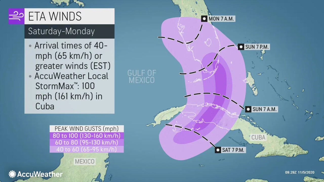
I think AccuWeather needs to update their graphic - the system will be influenced by the ULL and at best will be a hybrid system, while the AW graphic shows a wind forecast associated with a tropical system.
It should be noted that while Eta regaining hurricane strength cannot be ruled out, there is little support for that in the current guidance.
I think AccuWeather needs to update their graphic - the system will be influenced by the ULL and at best will be a hybrid system, while the AW graphic shows a wind forecast associated with a tropical system.
1 likes
-
Emmett_Brown

- Category 5

- Posts: 1433
- Joined: Wed Aug 24, 2005 9:10 pm
- Location: Sarasota FL
Re: ATL: ETA - Tropical Depression - Discussion
NHC's 10am forecast track for Eta is a nice example of how the NHC does not always closely follow the TVCN. TVCN is over the Yucatan Channel, and NHC is still taking it across central Cuba. The expert human element 
Last edited by Emmett_Brown on Thu Nov 05, 2020 10:10 am, edited 1 time in total.
1 likes
-
AutoPenalti
- Category 5
- Posts: 4091
- Age: 29
- Joined: Mon Aug 17, 2015 4:16 pm
- Location: Ft. Lauderdale, Florida
Re: ATL: ETA - Tropical Depression - Discussion
At this rate, Florida may be out of the cone entirely by tomorrow. The Florida shield strikes again. 
Gotta keep checking runs first, still lot's of time to track this.
Gotta keep checking runs first, still lot's of time to track this.
2 likes
The posts in this forum are NOT official forecasts and should not be used as such. They are just the opinion of the poster and may or may not be backed by sound meteorological data. They are NOT endorsed by any professional institution or STORM2K. For official information, please refer to products from the NHC and NWS.
Model Runs Cheat Sheet:
GFS (5:30 AM/PM, 11:30 AM/PM)
HWRF, GFDL, UKMET, NAVGEM (6:30-8:00 AM/PM, 12:30-2:00 AM/PM)
ECMWF (1:45 AM/PM)
TCVN is a weighted averaged
-
TheProfessor

- Professional-Met

- Posts: 3506
- Age: 29
- Joined: Tue Dec 03, 2013 10:56 am
- Location: Wichita, Kansas
Re: ATL: ETA - Tropical Depression - Discussion
This system may find itself in a healthier environment in the Gulf(or in the case it goes further east than expected and winds up in the straits later than the forecast.) but early on the storm is likely to be sheared with the convection off to the northeast. Because of this the southwest shift by NHC doesn't do anything to decrease the current flooding threat for SFL if we are to assume the convection will focused on the northeast side. If the storm looks like what the GFS shows it may actually put SFL under the heaviest precip, so no one should let their guard down right now.
2 likes
An alumnus of The Ohio State University.
Your local National Weather Service office is your best source for weather information.
Your local National Weather Service office is your best source for weather information.
-
TheStormExpert
Re: ATL: ETA - Tropical Depression - Discussion
Encouraging news to see the track shift south and bend more west at days 4-5. Probably will just be a rain event for South Florida if trends continue. I wouldn’t be surprised to see more south and west shifts.

0 likes
-
TheStormExpert
Re: ATL: ETA - Tropical Depression - Discussion
AutoPenalti wrote:At this rate, Florida may be out of the cone entirely by tomorrow. The Florida shield strikes again.
Gotta keep checking runs first, still lot's of time to track this.
Yep. We deflect every storm that comes our way.
0 likes
-
ncforecaster89
- Category 1

- Posts: 263
- Age: 55
- Joined: Sat Oct 20, 2018 12:32 pm
- Contact:
Re: ATL: ETA - Tropical Depression - Discussion
Emmett_Brown wrote:NHC's 10am forecast track for Eta is a nice example of how the NHC does not always closely follow the TVCN. TVCN is over the Yucatan Channel, and NHC is still taking it across central Cuba. The expert human element
It’s also important to note that the TVCN consensus would be essentially where the NHC has the track if one were to ignore the major outlier (e.g., the UKMET model)...which is dramatically skewing the aforementioned TVCN.
1 likes
Re: ATL: ETA - Tropical Depression - Discussion
TheStormExpert wrote:Encouraging news to see the track shift south and bend more west at days 4-5. Probably will just be a rain event for South Florida if trends continue. I wouldn’t be surprised to see more south and west shifts.
https://i.imgur.com/lAz4ZIq.png
Looking at the latest NHC official track, i'd guess that a bit slower of an evolutionary process would tend to result in a "smoother" south to north track a bit closer to the east of Isle of Pines and then across Cuba with perhaps a closer approach to Key West.
0 likes
Andy D
(For official information, please refer to the NHC and NWS products.)
(For official information, please refer to the NHC and NWS products.)
-
Iceresistance

- Category 5
- Posts: 9564
- Age: 22
- Joined: Sat Oct 10, 2020 9:45 am
- Location: Tecumseh, OK/Norman, OK
Re: ATL: ETA - Tropical Depression - Discussion
cycloneye wrote:wxman57 wrote:Looks like a remnant swirl of low clouds this morning. NHC should be downgrading it to a post-tropical remnant low shortly. Will they even continue advisories? Remember that when Harvey weakened to a remnant low in the central Caribbean the NHC stopped advisories, even though Harvey was predicted to redevelop (but in 4-5 days). Since Eta is predicted to redevelop over the weekend, I think the NHC will continue advisories. I now have it by the western tip of Cuba next Tuesday. NHC will likely shift that 120 hr point west and south.
They did not put post -tropical remnant low.INIT 05/1500Z 15.1N 87.8W 25 KT 30 MPH...INLAND
12H 06/0000Z 15.7N 88.0W 25 KT 30 MPH...INLAND
24H 06/1200Z 16.8N 87.6W 25 KT 30 MPH...OVER WATER
36H 07/0000Z 17.8N 86.2W 30 KT 35 MPH
48H 07/1200Z 19.0N 84.5W 35 KT 40 MPH
60H 08/0000Z 20.1N 83.0W 45 KT 50 MPH
72H 08/1200Z 21.3N 81.2W 50 KT 60 MPH
96H 09/1200Z 23.0N 80.0W 50 KT 60 MPH
120H 10/1200Z 24.0N 83.0W 55 KT 65 MPH
It has enough convection close to the center to keep going
0 likes
Bill 2015 & Beta 2020
Winter 2020-2021
All observations are in Tecumseh, OK unless otherwise noted.
Winter posts are focused mainly for Oklahoma & Texas.
Take any of my forecasts with a grain of salt, refer to the NWS, SPC, and NHC for official information
Never say Never with weather! Because ANYTHING is possible!
Winter 2020-2021
All observations are in Tecumseh, OK unless otherwise noted.
Winter posts are focused mainly for Oklahoma & Texas.
Take any of my forecasts with a grain of salt, refer to the NWS, SPC, and NHC for official information
Never say Never with weather! Because ANYTHING is possible!
-
Iceresistance
- Category 5
- Posts: 9564
- Age: 22
- Joined: Sat Oct 10, 2020 9:45 am
- Location: Tecumseh, OK/Norman, OK
Re: ATL: ETA - Tropical Depression - Discussion
TheStormExpert wrote:AutoPenalti wrote:At this rate, Florida may be out of the cone entirely by tomorrow. The Florida shield strikes again.
Gotta keep checking runs first, still lot's of time to track this.
Yep. We deflect every storm that comes our way.
But remember that Eta is becoming harder to track.
0 likes
Bill 2015 & Beta 2020
Winter 2020-2021
All observations are in Tecumseh, OK unless otherwise noted.
Winter posts are focused mainly for Oklahoma & Texas.
Take any of my forecasts with a grain of salt, refer to the NWS, SPC, and NHC for official information
Never say Never with weather! Because ANYTHING is possible!
Winter 2020-2021
All observations are in Tecumseh, OK unless otherwise noted.
Winter posts are focused mainly for Oklahoma & Texas.
Take any of my forecasts with a grain of salt, refer to the NWS, SPC, and NHC for official information
Never say Never with weather! Because ANYTHING is possible!
-
Iceresistance
- Category 5
- Posts: 9564
- Age: 22
- Joined: Sat Oct 10, 2020 9:45 am
- Location: Tecumseh, OK/Norman, OK
Re: ATL: ETA - Tropical Depression - Discussion
TheStormExpert wrote:Encouraging news to see the track shift south and bend more west at days 4-5. Probably will just be a rain event for South Florida if trends continue. I wouldn’t be surprised to see more south and west shifts.
https://i.imgur.com/lAz4ZIq.png
But what about Louisiana? They may be hit for the 6th time!
Last edited by Iceresistance on Thu Nov 05, 2020 10:53 am, edited 1 time in total.
0 likes
Bill 2015 & Beta 2020
Winter 2020-2021
All observations are in Tecumseh, OK unless otherwise noted.
Winter posts are focused mainly for Oklahoma & Texas.
Take any of my forecasts with a grain of salt, refer to the NWS, SPC, and NHC for official information
Never say Never with weather! Because ANYTHING is possible!
Winter 2020-2021
All observations are in Tecumseh, OK unless otherwise noted.
Winter posts are focused mainly for Oklahoma & Texas.
Take any of my forecasts with a grain of salt, refer to the NWS, SPC, and NHC for official information
Never say Never with weather! Because ANYTHING is possible!
-
wxman57
- Moderator-Pro Met
- Posts: 23169
- Age: 68
- Joined: Sat Jun 21, 2003 8:06 pm
- Location: Houston, TX (southwest)
Re: ATL: ETA - Tropical Depression - Discussion
Emmett_Brown wrote:NHC's 10am forecast track for Eta is a nice example of how the NHC does not always closely follow the TVCN. TVCN is over the Yucatan Channel, and NHC is still taking it across central Cuba. The expert human element
Another factor is that they (NHC) don't want to make any drastic change from advisory to advisory. That IS a curious consensus track, though.
0 likes

Re: ATL: ETA - Tropical Depression - Discussion
TheStormExpert wrote:AutoPenalti wrote:At this rate, Florida may be out of the cone entirely by tomorrow. The Florida shield strikes again.
Gotta keep checking runs first, still lot's of time to track this.
Yep. We deflect every storm that comes our way.
If only it could get deflected the other way...
0 likes
Georges '98, Irene '99, Frances '04, Jeanne '04, Katrina '05, Wilma '05, Gustav '08, Isaac '12, Matthew '16, Florence '18, Michael '18, Ian '22
-
wxman57
- Moderator-Pro Met
- Posts: 23169
- Age: 68
- Joined: Sat Jun 21, 2003 8:06 pm
- Location: Houston, TX (southwest)
Re: ATL: ETA - Tropical Depression - Discussion
Iceresistance wrote:TheStormExpert wrote:Encouraging news to see the track shift south and bend more west at days 4-5. Probably will just be a rain event for South Florida if trends continue. I wouldn’t be surprised to see more south and west shifts.
https://i.imgur.com/lAz4ZIq.png
But what about Louisiana? They may be hit for the 5th time!
I've had my money on Louisiana for the past week. However, conditions across the northern Gulf will be a lot more hostile than they were with previous storms. Might not survive to reach the coast.
2 likes
Who is online
Users browsing this forum: No registered users and 51 guests