ATL: ETA - Models

Moderator: S2k Moderators

Message
Author
AutoPenalti
Category 5
Category 5
Posts: 4030
Age: 29
Joined: Mon Aug 17, 2015 4:16 pm
Location: Ft. Lauderdale, Florida

Re: ATL: ETA - Models

#1181 Postby AutoPenalti » Thu Nov 05, 2020 12:29 pm


Just a tad weaker.
0 likes   
The posts in this forum are NOT official forecasts and should not be used as such. They are just the opinion of the poster and may or may not be backed by sound meteorological data. They are NOT endorsed by any professional institution or STORM2K. For official information, please refer to products from the NHC and NWS.


Model Runs Cheat Sheet:
GFS (5:30 AM/PM, 11:30 AM/PM)
HWRF, GFDL, UKMET, NAVGEM (6:30-8:00 AM/PM, 12:30-2:00 AM/PM)
ECMWF (1:45 AM/PM)

TCVN
is a weighted averaged

TheStormExpert

Re: ATL: ETA - Models

#1182 Postby TheStormExpert » Thu Nov 05, 2020 12:29 pm

AutoPenalti wrote:
MJGarrison wrote:
AutoPenalti wrote:Am I reading this wrong? HWRF seems to be quite the opposite of big loser. It's not the lowest but it's not the highest either..

Wxman specifically was calling out Day 4


Sent from my iPad using Tapatalk

Oh, the way he wrote it out I thought he was saying all 4 days.

Right now I wouldn’t be putting any trust in any of the two hurricane models as we don’t even have an established area of low pressure yet.
0 likes   

User avatar
Spacecoast
Category 2
Category 2
Posts: 758
Joined: Thu Aug 31, 2017 2:03 pm

Re: ATL: ETA - Models

#1183 Postby Spacecoast » Thu Nov 05, 2020 12:29 pm

AutoPenalti wrote:
wxman57 wrote:Here's a website (Univ. of Albany) that has track and intensity verification for storms.

Eta: http://www.atmos.albany.edu/facstaff/tang/tcguidance/al292020/

Worst models for track are NGX/NOGAPS and the UKMET.

http://wxman57.com/images/Etatrack.png

HWRF is the big loser for intensity. EC is best at day 4, but only has one verification point.

http://wxman57.com/images/Etaintensity.png

Am I reading this wrong? HWRF seems to be quite the opposite of big loser. It's not the lowest but it's not the highest either..

Top 20 models for lowest track error (Eta) at 96 hr...

Image
#22: HWRF Day 1: 44.9 Day 2: 83.1 Day 3: 107.2 Day 4: 79.1 Day 5: 60.6


Top 20 models for lowest intensity error (Eta) at 96 hr...
Image
way down the list is HWRF
HWRF Day 1: 14.4 Day2: 18.1 Day 3: 23.8 Day 4: 19.1 Day 5: 3.2 -

Bottom line: HWRF is good for 1st 48 hrs on intensity, but degrades rapidly thereafter.
0 likes   

TheStormExpert

Re: ATL: ETA - Models

#1184 Postby TheStormExpert » Thu Nov 05, 2020 12:54 pm

The 500mb pattern on the 12z GFS is something you’d expect to see more in August or September and not November. With a Strong Bermuda High just NE of Bermuda. This is the dangerous steering pattern several on here were claiming would show up in September but never did thanks to the recurving typhoons throwing a wrench in things.
1 likes   

User avatar
wxman57
Moderator-Pro Met
Moderator-Pro Met
Posts: 22978
Age: 67
Joined: Sat Jun 21, 2003 8:06 pm
Location: Houston, TX (southwest)

Re: ATL: ETA - Models

#1185 Postby wxman57 » Thu Nov 05, 2020 1:17 pm

CyclonicFury wrote:
wxman57 wrote:Here's a website (Univ. of Albany) that has track and intensity verification for storms.

Eta: http://www.atmos.albany.edu/facstaff/tang/tcguidance/al292020/

Worst models for track are NGX/NOGAPS and the UKMET.

http://wxman57.com/images/Etatrack.png

HWRF is the big loser for intensity. EC is best at day 4, but only has one verification point.

http://wxman57.com/images/Etaintensity.png

How is the HWRF a big loser for intensity, when it consistently showed Eta becoming a Category 4 hurricane before it formed while the Euro showed only a TS/weak C1?

EC was the big loser early on, but the HWRF won the prize at 96 hrs.
0 likes   

TheStormExpert

Re: ATL: ETA - Models

#1186 Postby TheStormExpert » Thu Nov 05, 2020 1:23 pm

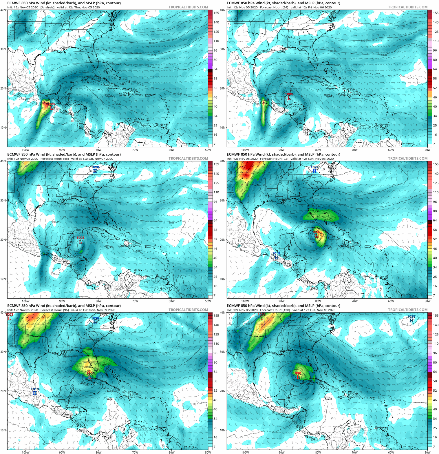
Once again 12z Euro turns Eta WNW south of Key West only slightly stronger 00z.
0 likes   

User avatar
aspen
Category 5
Category 5
Posts: 8818
Joined: Sat Oct 12, 2019 7:10 pm
Location: Connecticut, USA

Re: ATL: ETA - Models

#1187 Postby aspen » Thu Nov 05, 2020 1:27 pm

The brief dive into the Yucatán Channel after going through the Keys is due to a broad, gyre-like setup for Eta. There’s another part of the gyre that Eta rotates around and causes this motion.
2 likes   
Irene '11 Sandy '12 Hermine '16 5/15/2018 Derecho Fay '20 Isaias '20 Elsa '21 Henri '21 Ida '21

I am only a meteorology enthusiast who knows a decent amount about tropical cyclones. Look to the professional mets, the NHC, or your local weather office for the best information.

User avatar
gatorcane
S2K Supporter
S2K Supporter
Posts: 23691
Age: 47
Joined: Sun Mar 13, 2005 3:54 pm
Location: Boca Raton, FL

Re: ATL: ETA - Models

#1188 Postby gatorcane » Thu Nov 05, 2020 1:39 pm

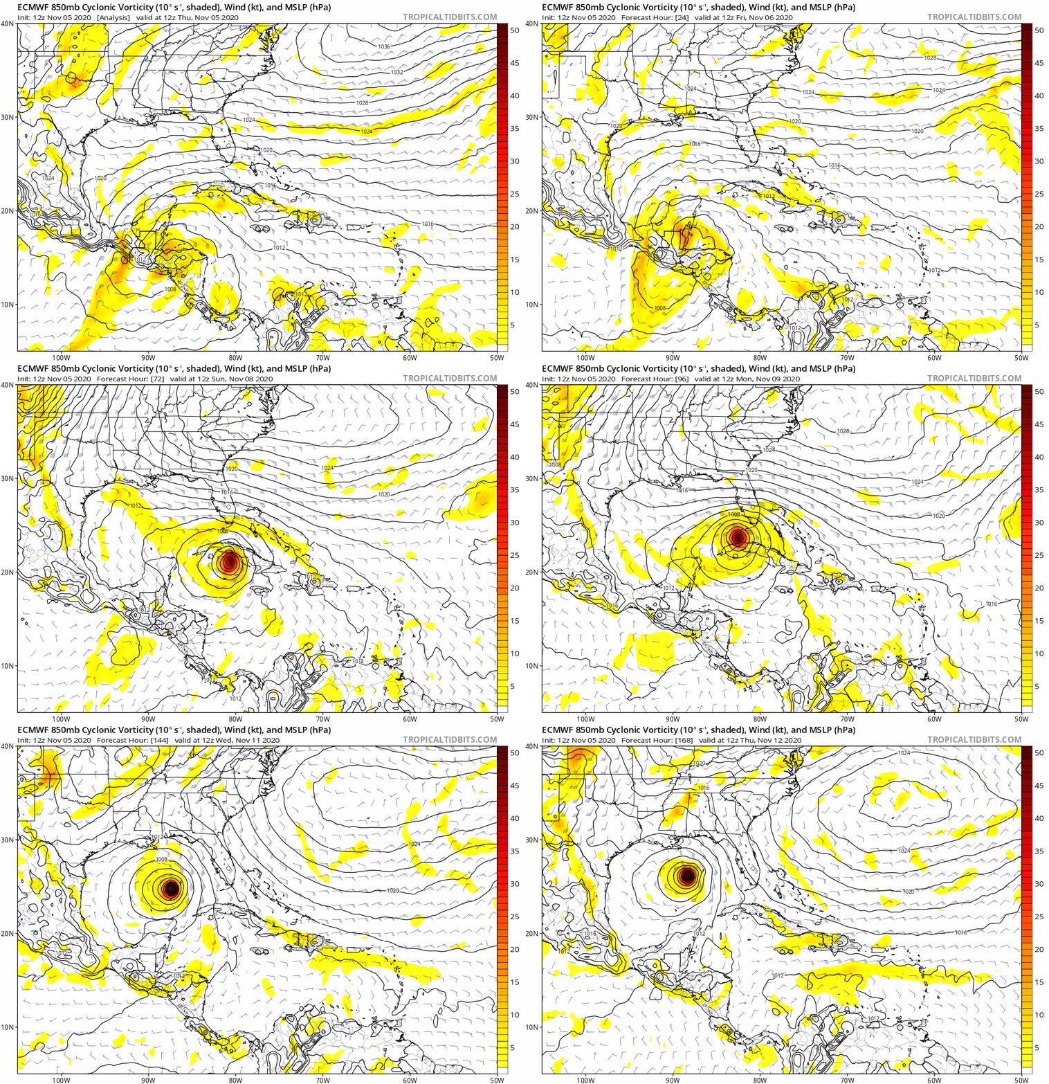
Blocked from moving into the Florida peninsula and off into the Gulf towards northern Gulf coast it goes...again...

Image
0 likes   

TheStormExpert

Re: ATL: ETA - Models

#1189 Postby TheStormExpert » Thu Nov 05, 2020 1:42 pm

If the 12z GFS were to verify it would bring some strong winds to South Florida come early Monday morning.

 https://twitter.com/tropicalupdate/status/1324401753018769409


0 likes   

AutoPenalti
Category 5
Category 5
Posts: 4030
Age: 29
Joined: Mon Aug 17, 2015 4:16 pm
Location: Ft. Lauderdale, Florida

Re: ATL: ETA - Models

#1190 Postby AutoPenalti » Thu Nov 05, 2020 2:10 pm

gatorcane wrote:Blocked from moving into the Florida peninsula and off into the Gulf towards northern Gulf coast it goes...again...

https://i.postimg.cc/Qth1gRnh/ecmwf-uv850-vort-watl-fh0-168.gif

Never seen anything quite like it. Pretty crazy how it just misses everything except the lower keys.
0 likes   
The posts in this forum are NOT official forecasts and should not be used as such. They are just the opinion of the poster and may or may not be backed by sound meteorological data. They are NOT endorsed by any professional institution or STORM2K. For official information, please refer to products from the NHC and NWS.


Model Runs Cheat Sheet:
GFS (5:30 AM/PM, 11:30 AM/PM)
HWRF, GFDL, UKMET, NAVGEM (6:30-8:00 AM/PM, 12:30-2:00 AM/PM)
ECMWF (1:45 AM/PM)

TCVN
is a weighted averaged

User avatar
SFLcane
S2K Supporter
S2K Supporter
Posts: 10163
Age: 47
Joined: Sat Jun 05, 2010 1:44 pm
Location: Lake Worth Florida

Re: ATL: ETA - Models

#1191 Postby SFLcane » Thu Nov 05, 2020 2:15 pm

I would really take any model guidance with extreme caution Until something gets going in the nw Caribbean which will not be until late tomorrow into Saturday.
0 likes   

User avatar
SFLcane
S2K Supporter
S2K Supporter
Posts: 10163
Age: 47
Joined: Sat Jun 05, 2010 1:44 pm
Location: Lake Worth Florida

Re: ATL: ETA - Models

#1192 Postby SFLcane » Thu Nov 05, 2020 2:26 pm

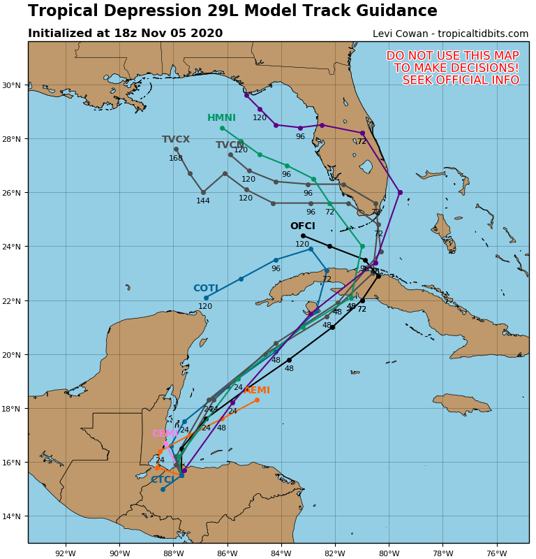
Big shift east with tcvn now across SFL!

Image
Last edited by SFLcane on Thu Nov 05, 2020 2:34 pm, edited 1 time in total.
1 likes   

AutoPenalti
Category 5
Category 5
Posts: 4030
Age: 29
Joined: Mon Aug 17, 2015 4:16 pm
Location: Ft. Lauderdale, Florida

Re: ATL: ETA - Models

#1193 Postby AutoPenalti » Thu Nov 05, 2020 2:32 pm

SFLcane wrote:Big shift east with tcvn now across SFL!

Either the UKMET has decided to shift east as well or it no longer considers it because of how much of an outlier it is.
0 likes   
The posts in this forum are NOT official forecasts and should not be used as such. They are just the opinion of the poster and may or may not be backed by sound meteorological data. They are NOT endorsed by any professional institution or STORM2K. For official information, please refer to products from the NHC and NWS.


Model Runs Cheat Sheet:
GFS (5:30 AM/PM, 11:30 AM/PM)
HWRF, GFDL, UKMET, NAVGEM (6:30-8:00 AM/PM, 12:30-2:00 AM/PM)
ECMWF (1:45 AM/PM)

TCVN
is a weighted averaged

User avatar
Blown Away
S2K Supporter
S2K Supporter
Posts: 10145
Joined: Wed May 26, 2004 6:17 am

Re: ATL: ETA - Models

#1194 Postby Blown Away » Thu Nov 05, 2020 2:42 pm

SFLcane wrote:Big shift east with tcvn now across SFL!

https://i.postimg.cc/L6PxZ53X/DC597-D22-D2-AF-4060-A126-3-E2-F6-DC605-C7.png


The 18z guidance tracks look more reasonable than what has been shown on the previous models... Now I think we model watch and have some confidence...
2 likes   
Hurricane Eye Experience: David 79, Irene 99, Frances 04, Jeanne 04, Wilma 05... EYE COMING MY WAY IN 2024…
Hurricane Brush Experience: Andrew 92, Erin 95, Floyd 99, Matthew 16, Irma 17, Ian 22, Nicole 22…

User avatar
SFLcane
S2K Supporter
S2K Supporter
Posts: 10163
Age: 47
Joined: Sat Jun 05, 2010 1:44 pm
Location: Lake Worth Florida

Re: ATL: ETA - Models

#1195 Postby SFLcane » Thu Nov 05, 2020 2:50 pm

Another look..

Image
0 likes   

User avatar
chaser1
S2K Supporter
S2K Supporter
Posts: 5464
Age: 64
Joined: Sat Oct 15, 2005 5:59 pm
Location: Longwood, Fl

Re: ATL: ETA - Models

#1196 Postby chaser1 » Thu Nov 05, 2020 2:53 pm

SFLcane wrote:Big shift east with tcvn now across SFL!

https://i.postimg.cc/L6PxZ53X/DC597-D22-D2-AF-4060-A126-3-E2-F6-DC605-C7.png


I don't think the TVCN takes the 12Z Euro into account though. I'd think that would weight it more westward again
0 likes   
Andy D

(For official information, please refer to the NHC and NWS products.)

User avatar
Emmett_Brown
Category 5
Category 5
Posts: 1432
Joined: Wed Aug 24, 2005 9:10 pm
Location: Sarasota FL

Re: ATL: ETA - Models

#1197 Postby Emmett_Brown » Thu Nov 05, 2020 3:15 pm

Eta is shaping up to be the ultimate nowcast storm with a potentially dizzying track. However, while the operational runs are still moving all over the place, I do think model ensembles are probably pretty useful in this situation. The 12Z GEFS shows lighter shear over the E GOM for M-W next week than it did a couple of days ago
1 likes   

LarryWx
S2K Supporter
S2K Supporter
Posts: 6305
Joined: Sun Sep 07, 2003 2:04 pm
Location: GA

Re: ATL: ETA - Models

#1198 Postby LarryWx » Thu Nov 05, 2020 3:22 pm

12Z EPS: look at the Gulf! :eek: :eek:
Image
3 likes   
Personal Forecast Disclaimer:
The posts in this forum are NOT official forecasts and should not be used as such. They are just the opinion of the poster and may or may not be backed by sound meteorological data. They are NOT endorsed by any professional institution or storm2k.org. For official information, please refer to the NHC and NWS products.

User avatar
Spacecoast
Category 2
Category 2
Posts: 758
Joined: Thu Aug 31, 2017 2:03 pm

Re: ATL: ETA - Models

#1199 Postby Spacecoast » Thu Nov 05, 2020 4:25 pm

Emmett_Brown wrote:Eta is shaping up to be the ultimate nowcast storm with a potentially dizzying track. However, while the operational runs are still moving all over the place, I do think model ensembles are probably pretty useful in this situation. The 12Z GEFS shows lighter shear over the E GOM for M-W next week than it did a couple of days ago

LarryWx wrote:12Z EPS: look at the Gulf!

12z EPS windtracks... Starting to settle out on strong TS in the Gulf. Lots of rain in store for SFL, & W coast.
Image

12z GEFS - I like it when members cluster together with lower spread / higher confidence. Although there seems to be fewer members present in WCar on this run. The other members may have been left behind, or drifted into EPAC.
Image
2 likes   

User avatar
gatorcane
S2K Supporter
S2K Supporter
Posts: 23691
Age: 47
Joined: Sun Mar 13, 2005 3:54 pm
Location: Boca Raton, FL

Re: ATL: ETA - Models

#1200 Postby gatorcane » Thu Nov 05, 2020 4:45 pm

12Z Euro with some strong wind gusts over Florida maybe to gale force over the water, makes sense since this storm may become hybrid where wind field is broad and there should be a tight pressure gradient with building high pressure over the eastern seaboard,

Image
0 likes   


Return to “2020”

Who is online

Users browsing this forum: No registered users and 10 guests