
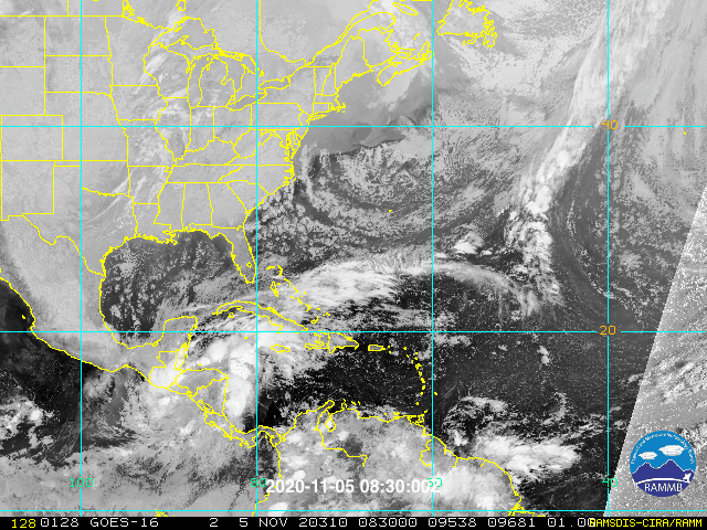
Zooming out with the satellite view, it is really starting to get that look. The low may very well form further east or relocate east.
I see the old center re-emerging in the EPAC, with the storms in the Caribbean not part of Eta's low, except may the area in the far west part of the Gulf of Hondorus.
ATL: ETA - Post-Tropical - Discussion
Moderator: S2k Moderators
-
TheStormExpert
Re: ATL: ETA - Tropical Depression - Discussion
Nuno wrote:TheStormExpert wrote:Nuno wrote:
You seem awfully confident this will be nothing for Florida.
I never said it would be nothing, but I think it’ll just be a rain event for Florida, especially South Florida.
I suppose I worry that it could be like 1999's Irene, which while just a rain event for SFL was quite damaging in its flooding. The S & W trends worry me as it puts us on the dirty side.
Irene 1999 took a track from SW to NE through the peninsula though.
0 likes
Re: ATL: ETA - Tropical Depression - Discussion
Cat5James wrote:Not directly related to ETA but Those rain estimates for SE Florida are looking more likely... I’m in the Suburbs of Ft Lauderdale and we’ve already picked up an inch in the last hour... streets already flooded.
Yea, those rain totals look crazy!
If they hold up, Miami, especially, will be flooded insanely. All the way up the coast, actually, but Miami seems to have major problems lately with flooding after any kind of heavy rain, never mind a TS.
2 likes
Cleo - 1964, Betsy - 1965, David - 1979, Andrew - 1992, Charlie (Francis, Ivan, Jeanne) - 2004, Irma - 2017, Ian - 2022, Milton - 2024
-
AdamFirst

- S2K Supporter

- Posts: 2490
- Age: 36
- Joined: Thu Aug 14, 2008 10:54 am
- Location: Port Saint Lucie, FL
Re: ATL: ETA - Tropical Depression - Discussion
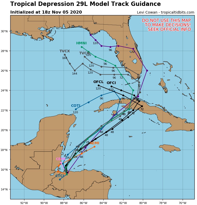
wxman57 wrote:Well, consensus (TVCN) shifted from up the east coast of the Yucatan to the central Gulf at 6Z to clipping the western tip of Cuba and into the central Gulf at 12Z to cutting across central Cuba and into Miami at 18Z. Quite a bit of jumping around.
Perhaps they may be taking a center reformation in account? Or would the consensus models go off of BEST track data?
0 likes
Dolphins Marlins Canes Golden Panthers HEAT
Andrew 1992 - Irene 1999 - Frances 2004 - Jeanne 2004 - Wilma 2005 - Fay 2008 - Isaac 2012 - Matthew 2016 - Irma 2017 - Dorian 2019 - Ian 2022 - Nicole 2022 - Milton 2024
Andrew 1992 - Irene 1999 - Frances 2004 - Jeanne 2004 - Wilma 2005 - Fay 2008 - Isaac 2012 - Matthew 2016 - Irma 2017 - Dorian 2019 - Ian 2022 - Nicole 2022 - Milton 2024

-
AutoPenalti
- Category 5

- Posts: 4091
- Age: 29
- Joined: Mon Aug 17, 2015 4:16 pm
- Location: Ft. Lauderdale, Florida
Re: ATL: ETA - Tropical Depression - Discussion
AdamFirst wrote:wxman57 wrote:Well, consensus (TVCN) shifted from up the east coast of the Yucatan to the central Gulf at 6Z to clipping the western tip of Cuba and into the central Gulf at 12Z to cutting across central Cuba and into Miami at 18Z. Quite a bit of jumping around.
Perhaps they may be taking a center reformation in account? Or would the consensus models go off of BEST track data?
FWIW I found out what the TVCN actually does other than average out solutions...
TVCN takes the the average of the last two runs of the members within the TCON plus the ECMWF model.
-The TCON consensus is the GUNA consensus plus the HWRF model.
-The GUNA model is a consensus of the interpolated versions of the HMON, UKMET with quality control applied to NAVGEM, and GFS.
So the TVCN involves the ECMWF, HWRF, HMON, UKMET, NAVGEM, and GFS.
I think it takes into account the Best Track Surface Plot Analysis as well for Initialization.
Last edited by AutoPenalti on Thu Nov 05, 2020 3:47 pm, edited 2 times in total.
5 likes
The posts in this forum are NOT official forecasts and should not be used as such. They are just the opinion of the poster and may or may not be backed by sound meteorological data. They are NOT endorsed by any professional institution or STORM2K. For official information, please refer to products from the NHC and NWS.
Model Runs Cheat Sheet:
GFS (5:30 AM/PM, 11:30 AM/PM)
HWRF, GFDL, UKMET, NAVGEM (6:30-8:00 AM/PM, 12:30-2:00 AM/PM)
ECMWF (1:45 AM/PM)
TCVN is a weighted averaged

Re: ATL: ETA - Tropical Depression - Discussion
Really looking like convection congealing just north of far W. Honduras. I believe "lift-off" will emanate from that point. If so, next question is "how quickly" will it deepen and how soon before tracking NE.
0 likes
Andy D
(For official information, please refer to the NHC and NWS products.)
(For official information, please refer to the NHC and NWS products.)
-
Miami Storm Tracker

- Category 4

- Posts: 916
- Age: 68
- Joined: Sun Jun 13, 2010 10:12 pm
- Location: Key Largo, Fla.
- Contact:
Re: ATL: ETA - Tropical Depression - Discussion
Good Information to know Auto
Once we do get a COC for a point to start with the track of what ever develops should become more clear.
Once we do get a COC for a point to start with the track of what ever develops should become more clear.
2 likes
-
Weatherboy1

- Category 5
- Posts: 1190
- Age: 50
- Joined: Mon Jul 05, 2004 1:50 pm
- Location: Jupiter/Sarasota, FL
Re: ATL: ETA - Tropical Depression - Discussion
Convection really starting to blow up (technical weather term there I know lol) in NW Caribbean. Have to think center reformation won’t take a heck of a lot longer if this continues
0 likes
-
TheStormExpert
Re: ATL: ETA - Tropical Depression - Discussion
Winds up to 30kts. now as of the 4pm advisory, here's the latest visible.

2 likes
-
SFLcane

- S2K Supporter
- Posts: 10281
- Age: 48
- Joined: Sat Jun 05, 2010 1:44 pm
- Location: Lake Worth Florida
Re: ATL: ETA - Tropical Depression - Discussion
Another one bites the dust apparently here across SFL just about out of the cone. UKMET is like the Euro.
0 likes

Re: ATL: ETA - Tropical Depression - Discussion
SFLcane wrote:Another one bites the dust apparently here across SFL just about out of the cone. UKMET is like the Euro.
Most of the weather in the NE quadrant... cone is only showing where the center will be... I highly doubt that concentration of bad weather misses S FL
0 likes
Re: ATL: ETA - Tropical Depression - Discussion
If anything these adjustments westward would mean all that rainfall originally projected to go to the Bahamas would
Be on top of the Penninsula...
Be on top of the Penninsula...
0 likes

Re: ATL: ETA - Tropical Depression - Discussion
TheStormExpert wrote:Nuno wrote:TheStormExpert wrote:I never said it would be nothing, but I think it’ll just be a rain event for Florida, especially South Florida.
I suppose I worry that it could be like 1999's Irene, which while just a rain event for SFL was quite damaging in its flooding. The S & W trends worry me as it puts us on the dirty side.
Irene 1999 took a track from SW to NE through the peninsula though.
I mean in its overall impacts. SFL was on the dirty side for Irene
0 likes
Andrew (1992), Irene (1999), Frances (2004), Katrina (2005), Wilma (2005), Fay (2008), Irma (2017), Eta (2020), Ian (2022)
-
jlauderdal
- S2K Supporter
- Posts: 7240
- Joined: Wed May 19, 2004 5:46 am
- Location: NE Fort Lauderdale
- Contact:
Re: ATL: ETA - Tropical Depression - Discussion
its still a big rain event...we already had an inch today.SFLcane wrote:Another one bites the dust apparently here across SFL just about out of the cone. UKMET is like the Euro.
2 likes
-
TheStormExpert
Re: ATL: ETA - Tropical Depression - Discussion
SFLcane wrote:Another one bites the dust apparently here across SFL just about out of the cone. UKMET is like the Euro.
I've began to lose count of how many storms we've been in the cone for over the past five seasons only to get sideswiped, or it completely misses to the north, east, west, or south.
This is surely some dumb luck!
Last edited by TheStormExpert on Thu Nov 05, 2020 4:09 pm, edited 1 time in total.
1 likes
Re: ATL: ETA - Tropical Depression - Discussion
SFLcane wrote:Another one bites the dust apparently here across SFL just about out of the cone. UKMET is like the Euro.
Its really not too different from the previous track. Until we know where the center is going to be, NHC is probably staying put for now. Regardless its going to be a very ugly few days
0 likes
Andrew (1992), Irene (1999), Frances (2004), Katrina (2005), Wilma (2005), Fay (2008), Irma (2017), Eta (2020), Ian (2022)
-
AutoPenalti
- Category 5
- Posts: 4091
- Age: 29
- Joined: Mon Aug 17, 2015 4:16 pm
- Location: Ft. Lauderdale, Florida
Re: ATL: ETA - Tropical Depression - Discussion
Meh, that track may shift back.
Remember the cone just expresses where the center may be. Impacts will be felt regardless.
Remember the cone just expresses where the center may be. Impacts will be felt regardless.
2 likes
The posts in this forum are NOT official forecasts and should not be used as such. They are just the opinion of the poster and may or may not be backed by sound meteorological data. They are NOT endorsed by any professional institution or STORM2K. For official information, please refer to products from the NHC and NWS.
Model Runs Cheat Sheet:
GFS (5:30 AM/PM, 11:30 AM/PM)
HWRF, GFDL, UKMET, NAVGEM (6:30-8:00 AM/PM, 12:30-2:00 AM/PM)
ECMWF (1:45 AM/PM)
TCVN is a weighted averaged
-
TheStormExpert
Re: ATL: ETA - Tropical Depression - Discussion
AutoPenalti wrote:Meh, that track may shift back.
Remember the cone just expresses where the center may be. Impacts will be felt regardless.
The trend this season is for the forecast cones to trend west as time progresses it seems, with only a few exceptions like Sally.
0 likes
-
SFLcane
- S2K Supporter
- Posts: 10281
- Age: 48
- Joined: Sat Jun 05, 2010 1:44 pm
- Location: Lake Worth Florida
Re: ATL: ETA - Tropical Depression - Discussion
Not to often you see the nhc not side by side with the TCVN consensus model. Not to sure what the overall thinking is.
2 likes
Who is online
Users browsing this forum: No registered users and 59 guests