ATL: ETA - Models
Moderator: S2k Moderators
-
gatorcane

- S2K Supporter

- Posts: 23708
- Age: 48
- Joined: Sun Mar 13, 2005 3:54 pm
- Location: Boca Raton, FL
Re: ATL: ETA - Models
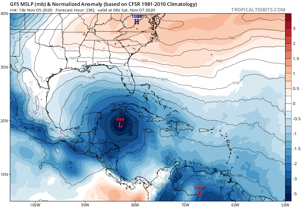
18Z GFS coming in a bit stronger and more consolidated through 36 hours.
0 likes

Re: ATL: ETA - Models
gatorcane wrote:Ut oh GFS much stronger
Ridge overhead doesnt look to extend quite as far South either... might make it further NE before turning this run
0 likes
-
TheStormExpert
Re: ATL: ETA - Models
gatorcane wrote:Ut oh GFS much stronger
Uh Happy Hour GFS what are you doing!?

0 likes
-
DESTRUCTION5

- Category 5

- Posts: 4430
- Age: 44
- Joined: Wed Sep 03, 2003 11:25 am
- Location: Stuart, FL
-
AutoPenalti
- Category 5
- Posts: 4091
- Age: 29
- Joined: Mon Aug 17, 2015 4:16 pm
- Location: Ft. Lauderdale, Florida
Re: ATL: ETA - Models
Rainfall would be off shore now.
0 likes
The posts in this forum are NOT official forecasts and should not be used as such. They are just the opinion of the poster and may or may not be backed by sound meteorological data. They are NOT endorsed by any professional institution or STORM2K. For official information, please refer to products from the NHC and NWS.
Model Runs Cheat Sheet:
GFS (5:30 AM/PM, 11:30 AM/PM)
HWRF, GFDL, UKMET, NAVGEM (6:30-8:00 AM/PM, 12:30-2:00 AM/PM)
ECMWF (1:45 AM/PM)
TCVN is a weighted averaged
-
AutoPenalti
- Category 5
- Posts: 4091
- Age: 29
- Joined: Mon Aug 17, 2015 4:16 pm
- Location: Ft. Lauderdale, Florida
Re: ATL: ETA - Models
Here's the trend from the past 6 runs starting with today's 18z, because why not.

2 likes
The posts in this forum are NOT official forecasts and should not be used as such. They are just the opinion of the poster and may or may not be backed by sound meteorological data. They are NOT endorsed by any professional institution or STORM2K. For official information, please refer to products from the NHC and NWS.
Model Runs Cheat Sheet:
GFS (5:30 AM/PM, 11:30 AM/PM)
HWRF, GFDL, UKMET, NAVGEM (6:30-8:00 AM/PM, 12:30-2:00 AM/PM)
ECMWF (1:45 AM/PM)
TCVN is a weighted averaged
-
Blown Away

- S2K Supporter
- Posts: 10253
- Joined: Wed May 26, 2004 6:17 am
Re: ATL: ETA - Models
If 18z GFS is right that could be a strong Cat 1 with Cat 2 gusts combined with strong pressure gradient in SFL in 3 days. 
0 likes
Hurricane Eye Experience: David 79, Irene 99, Frances 04, Jeanne 04, Wilma 05… Hurricane Brush Experience: Andrew 92, Erin 95, Floyd 99, Matthew 16, Irma 17, Ian 22, Nicole 22…
-
TheStormExpert
Re: ATL: ETA - Models
HOPEFULLY it's just another fluke run like the 00z run overnight, but this is 72hrs. out and worth taking into consideration.
0 likes
-
TheStormExpert
Re: ATL: ETA - Models
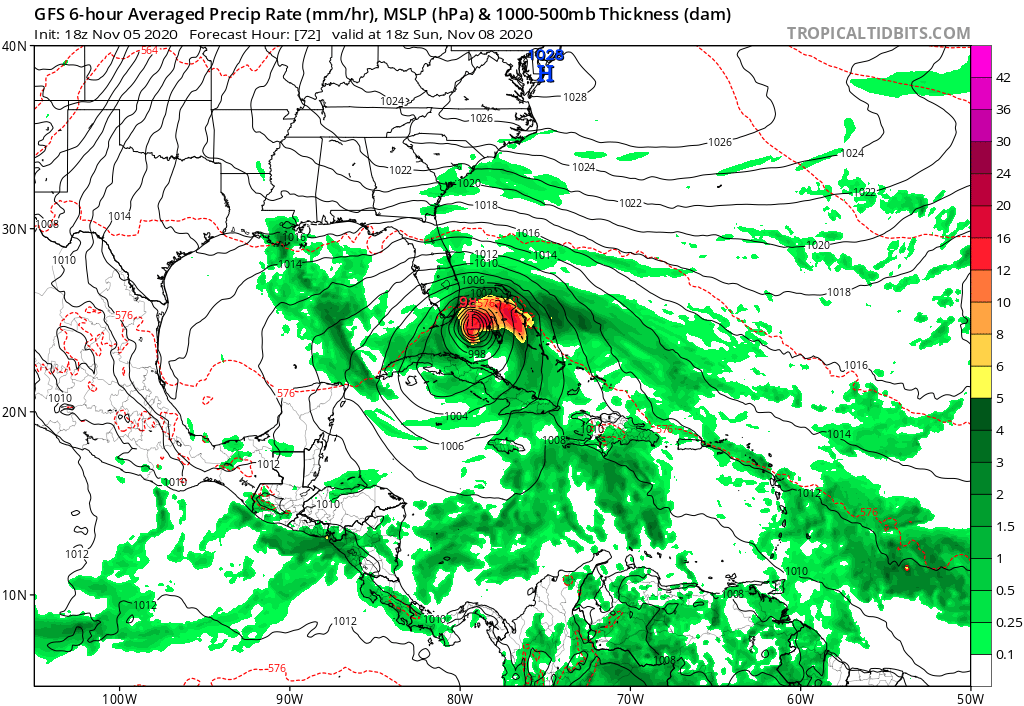
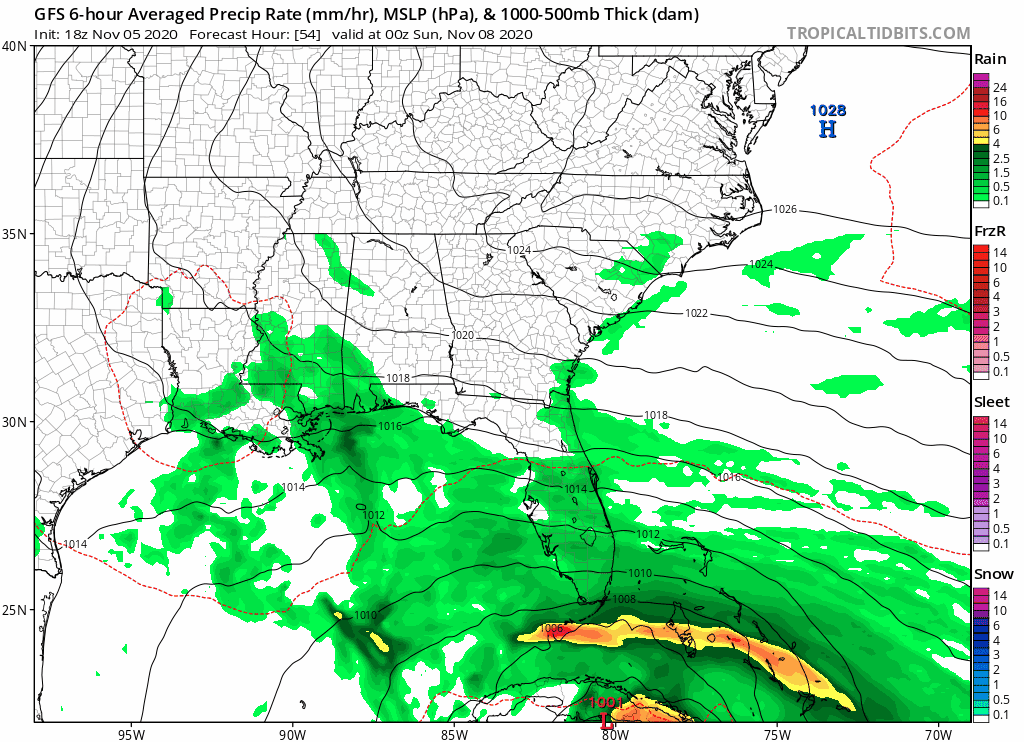
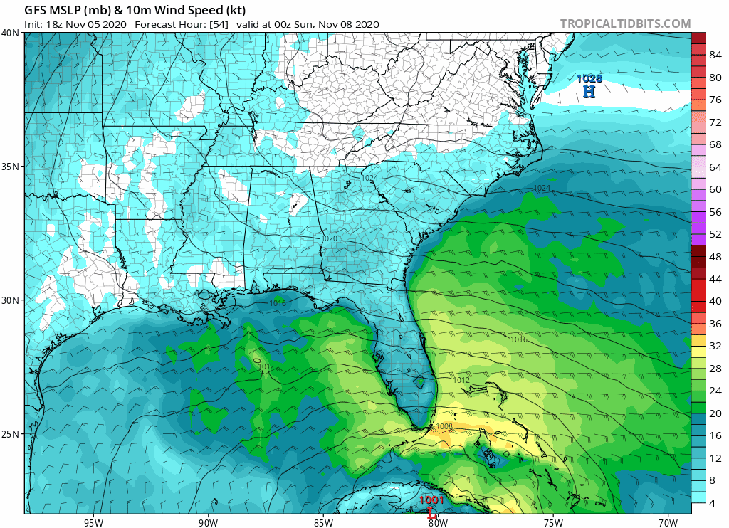
gatorcane wrote::eek: this could create some havoc here if it verifies
https://i.postimg.cc/TwB4jJvG/gfs-mslp-wind-seus-fh54-84.gif
Happy Hour GFS is like I didn't forgot you Floridians!
0 likes
-
jlauderdal
- S2K Supporter
- Posts: 7240
- Joined: Wed May 19, 2004 5:46 am
- Location: NE Fort Lauderdale
- Contact:
Re: ATL: ETA - Models
gatorcane wrote::eek: this could create some havoc here if it verifies
https://i.postimg.cc/TwB4jJvG/gfs-mslp-wind-seus-fh54-84.gif
Big time havoc, NHC is farther south and they are so good with track at this range we have to follow the line..that tsaid, even on their track the moisture feed into SE Florida is going to be impressive...we had an inch today and the road had standing water, it usually takes 2-3 inches to flood it
0 likes
-
SFLcane

- S2K Supporter
- Posts: 10281
- Age: 48
- Joined: Sat Jun 05, 2010 1:44 pm
- Location: Lake Worth Florida
Re: ATL: ETA - Models
AutoPenalti wrote:Here's the trend from the past 6 runs starting with today's 18z, because why not.
https://i.imgur.com/HwgRccq.gif
Why this is quite interesting trend today!
2 likes
-
Blown Away
- S2K Supporter
- Posts: 10253
- Joined: Wed May 26, 2004 6:17 am
Re: ATL: ETA - Models
jlauderdal wrote:gatorcane wrote::eek: this could create some havoc here if it verifies
https://i.postimg.cc/TwB4jJvG/gfs-mslp-wind-seus-fh54-84.gif
Big time havoc, NHC is farther south and they are so good with track at this range we have to follow the line..that tsaid, even on their track the moisture feed into SE Florida is going to be impressive...we had an inch today and the road had standing water, it usually takes 2-3 inches to flood it
It’s forward speed, 18z GFS very fast, and on the R and Euro on the L, so somewhere in the middle is probably correct, which is shown by the updated 18z TVCN.
0 likes
Hurricane Eye Experience: David 79, Irene 99, Frances 04, Jeanne 04, Wilma 05… Hurricane Brush Experience: Andrew 92, Erin 95, Floyd 99, Matthew 16, Irma 17, Ian 22, Nicole 22…
Re: ATL: ETA - Models
The old reincarnation-of-1950-King track. Not exactly, of course, but similar, with the slight hook into SFL. Always wondered if I'd ever get to see a track like that. *If* it did that......I kinda have a hard time believing it *wouldn't* be a hurricane.
2 likes
-
StPeteMike

- Category 2

- Posts: 653
- Joined: Thu Jun 07, 2018 11:26 pm
Re: ATL: ETA - Models
The models have sucked at forecasting the strength of storms in the NW Caribbean. Considerably underestimating the explosion in intensity with multiple storms. I wouldn’t be surprised to see a Cat 1 or even a Cat 2 before going through Cuba, just depends how long ETA takes to get itself together.
0 likes
The above post is not official and should not be used as such. It is the opinion of the poster and may or may not be backed by sound meteorological data. It is not endorsed by any professional institution or storm2k.org. For official information, please refer to the NHC and NWS products.
-
Blown Away
- S2K Supporter
- Posts: 10253
- Joined: Wed May 26, 2004 6:17 am
Re: ATL: ETA - Models
Patrick99 wrote:The old reincarnation-of-1950-King track. Not exactly, of course, but similar, with the slight hook into SFL. Always wondered if I'd ever get to see a track like that. *If* it did that......I kinda have a hard time believing it *wouldn't* be a hurricane.
Yeah, King is almost perfect analog. The 18z GFS has been smoothing out the herky jerky changes in the direction. 18z GFS almost identical to King’s track. If that LLC forms a bit farther ENE than the models show I think we will see a track closer to SFL. Pretty clear NHC going all in with Euro over GFS.
2 likes
Hurricane Eye Experience: David 79, Irene 99, Frances 04, Jeanne 04, Wilma 05… Hurricane Brush Experience: Andrew 92, Erin 95, Floyd 99, Matthew 16, Irma 17, Ian 22, Nicole 22…
Who is online
Users browsing this forum: No registered users and 13 guests