ATL: ETA - Models
Moderator: S2k Moderators
-
gatorcane

- S2K Supporter

- Posts: 23708
- Age: 48
- Joined: Sun Mar 13, 2005 3:54 pm
- Location: Boca Raton, FL
Re: ATL: ETA - Models
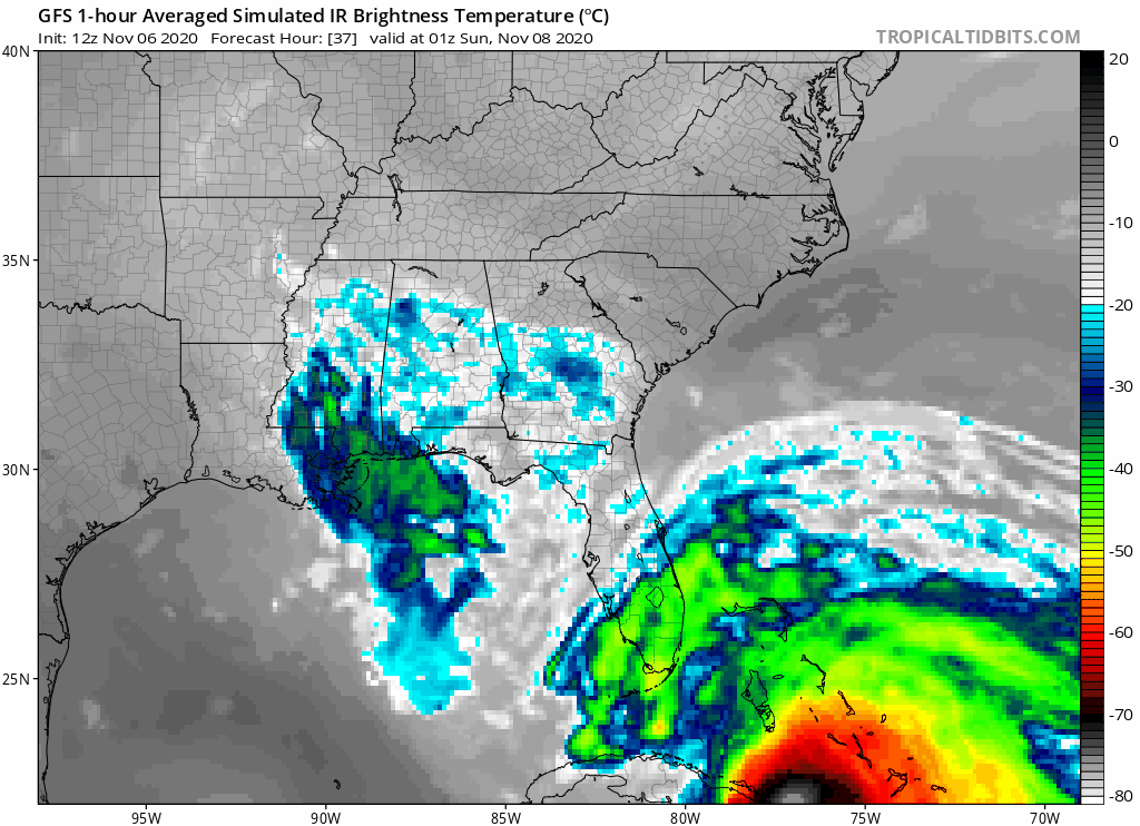
Closeup, some rain and breezy conditions but nothing to lose sleep over in South Florida if the model is right.
0 likes
-
TheStormExpert
Re: ATL: ETA - Models
gatorcane wrote:Closeup, some rain and breezy conditions but nothing to lose sleep over in South Florida if the model is right.
https://i.postimg.cc/Kzj8sm65/gfs-ir-seus-fh37-85.gif
These models have been so horrible this season, maybe we can put the thoughts of Eta regaining hurricane strength to rest.
0 likes
-
HurricaneFrances04
- Category 2

- Posts: 597
- Joined: Mon Jun 25, 2012 8:09 am
- Location: Fort Lauderdale, Florida
Re: ATL: ETA - Models
I think the +60 knot winds shown by some model solution is a result of the tight pressure gradient (mentioned earlier by wxman57) and not really a deepening tropical system. A late season sloppy mess.
0 likes
-
gatorcane
- S2K Supporter
- Posts: 23708
- Age: 48
- Joined: Sun Mar 13, 2005 3:54 pm
- Location: Boca Raton, FL
Re: ATL: ETA - Models
Much lower accumulated rainfall for South Florida on the 12Z GFS run. I am seeing maybe 3-4 inches instead of the 10+ inches it was showing the last two runs.
Last edited by gatorcane on Fri Nov 06, 2020 11:04 am, edited 1 time in total.
0 likes
-
Blown Away

- S2K Supporter
- Posts: 10253
- Joined: Wed May 26, 2004 6:17 am
Re: ATL: ETA - Models
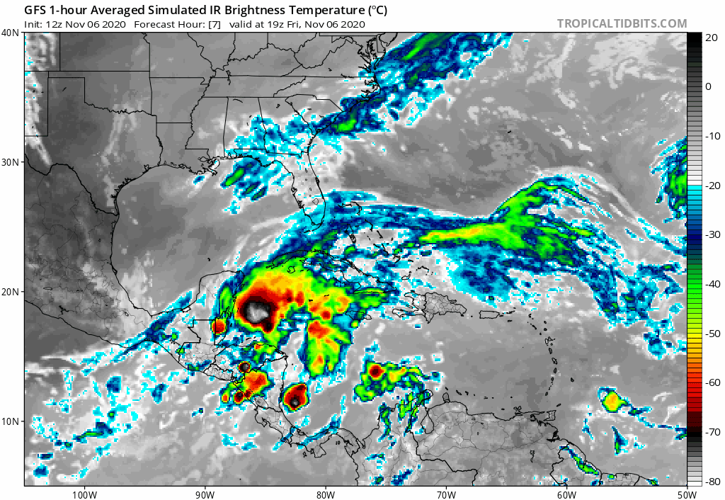
HurricaneFrances04 wrote:gatorcane wrote:Much weaker and sheared on the GFS not to mention it is transitioning to subtropical.
https://i.postimg.cc/jjz5J8zz/gfs-ir-watl-fh7-61.gif
Models seem pretty consistent in a hybrid mess near Florida. May be a case where someone 150 miles to the north get worse impacts than someone who is under the center.
Back n forth... 06z models showed nice closed low... Only conclusion I can see is that W bend out in to the GOM is gradually becoming a slight W drift over or just off Fl W coast after E coast FL landfall. The future track is looking more reasonable w/o all the herky jerky direction changes... It’s smoothing out, NE until Cuba, then NNW turn, then NW up to the Big Bend just offshore... It’s Hurricane King track, good analog.
2 likes
Hurricane Eye Experience: David 79, Irene 99, Frances 04, Jeanne 04, Wilma 05… Hurricane Brush Experience: Andrew 92, Erin 95, Floyd 99, Matthew 16, Irma 17, Ian 22, Nicole 22…
-
TheStormExpert
Re: ATL: ETA - Models
gatorcane wrote:Much lower accumulated rainfall for South Florida on the 12Z GFS run. I am seeing maybe 3-4 inches.
Palm Beach County probably wouldn’t even pick up more than 1-2 inches based on the 12z GFS’s satellite presentation.
0 likes
-
TheStormExpert
Re: ATL: ETA - Models
If the rest of the 12z models come in weaker I think we can forget any hurricane watches or warnings happening.
0 likes

Re: ATL: ETA - Models
Sun/mon light rain and 15 to 20mph is my take on this weather event (non issue).
0 likes
-
Loveweather12
- Tropical Storm

- Posts: 136
- Joined: Thu Aug 20, 2020 2:37 pm
Re: ATL: ETA - Models
TheStormExpert wrote:If the rest of the 12z models come in weaker I think we can forget any hurricane watches or warnings happening.
Nope I don’t see that happening. These storms are unpredictable. I remember many saying this was going in EPac. I’ve learned to let Mother Nature do her thing & I just prepare
4 likes
Re: ATL: ETA - Models
Got to love how it takes one model run to immediately change the mood of this place. 
9 likes
Andrew (1992), Irene (1999), Frances (2004), Katrina (2005), Wilma (2005), Fay (2008), Irma (2017), Eta (2020), Ian (2022)
-
TheStormExpert
Re: ATL: ETA - Models
Loveweather12 wrote:TheStormExpert wrote:If the rest of the 12z models come in weaker I think we can forget any hurricane watches or warnings happening.
Nope I don’t see that happening. These storms are unpredictable. I remember many saying this was going in EPac. I’ve learned to let Mother Nature do her thing & I just prepare
I’d hate to see the NHC put up hurricane watches or warnings again for this part of Florida only for the storm to underperform or fall apart. Remember Isaias? Just think of all the complacency that will continue to grow.
0 likes
-
Loveweather12
- Tropical Storm
- Posts: 136
- Joined: Thu Aug 20, 2020 2:37 pm
Re: ATL: ETA - Models
TheStormExpert wrote:Loveweather12 wrote:TheStormExpert wrote:If the rest of the 12z models come in weaker I think we can forget any hurricane watches or warnings happening.
Nope I don’t see that happening. These storms are unpredictable. I remember many saying this was going in EPac. I’ve learned to let Mother Nature do her thing & I just prepare
I’d hate to see the NHC put up hurricane watches or warnings again for this part of Florida only for the storm to underperform or fall apart. Remember Isaias? Just think of all the complacency that will continue to grow.
Yes. That complacency is so there now. I don’t even
Know if people would prepare for this one. I’m On treasure coast & I know people who don’t care. Complacency is a big issue & I hope people take stuff seriously in the future.
0 likes
-
SFLcane

- S2K Supporter
- Posts: 10281
- Age: 48
- Joined: Sat Jun 05, 2010 1:44 pm
- Location: Lake Worth Florida
Re: ATL: ETA - Models
I love S2k! If funny how when intensity is up on the models some posters vanish then when 1 run trends a bit weaker it’s time to downcast or there is nothing to worry. Fact is nhc does not put out forecast or change thoughts on 1 gfs run lol if the trend persist into tomorrow they maybe it’s a trend. Euro trended stronger and recon is on its way so we will know more later today. Let’s see if the rest of the 12z suite comes in weaker
10 likes
-
gatorcane
- S2K Supporter
- Posts: 23708
- Age: 48
- Joined: Sun Mar 13, 2005 3:54 pm
- Location: Boca Raton, FL
Re: ATL: ETA - Models
12Z HWRF out through 12 hours and already 7MB weaker.
Last edited by gatorcane on Fri Nov 06, 2020 11:42 am, edited 1 time in total.
0 likes
-
TheStormExpert
Re: ATL: ETA - Models
Loveweather12 wrote:TheStormExpert wrote:Loveweather12 wrote:Nope I don’t see that happening. These storms are unpredictable. I remember many saying this was going in EPac. I’ve learned to let Mother Nature do her thing & I just prepare
I’d hate to see the NHC put up hurricane watches or warnings again for this part of Florida only for the storm to underperform or fall apart. Remember Isaias? Just think of all the complacency that will continue to grow.
Yes. That complacency is so there now. I don’t even
Know if people would prepare for this one. I’m On treasure coast & I know people who don’t care. Complacency is a big issue & I hope people take stuff seriously in the future.
Honestly I saw small businesses boarding up for Isaias back in late-July/early-August. Can’t blame them but it’s a lot of work prepping for these storms. Rather be safe than sorry, but I don’t think Eta will be all that bad here.
0 likes
-
AutoPenalti
- Category 5

- Posts: 4091
- Age: 29
- Joined: Mon Aug 17, 2015 4:16 pm
- Location: Ft. Lauderdale, Florida
Re: ATL: ETA - Models
gatorcane wrote:12Z HWRF our through 12 hours and already 7MB weaker.
999 compared to 995 at 21hrs.
Coming in slightly weaker on approach.
HMON too.
0 likes
The posts in this forum are NOT official forecasts and should not be used as such. They are just the opinion of the poster and may or may not be backed by sound meteorological data. They are NOT endorsed by any professional institution or STORM2K. For official information, please refer to products from the NHC and NWS.
Model Runs Cheat Sheet:
GFS (5:30 AM/PM, 11:30 AM/PM)
HWRF, GFDL, UKMET, NAVGEM (6:30-8:00 AM/PM, 12:30-2:00 AM/PM)
ECMWF (1:45 AM/PM)
TCVN is a weighted averaged
-
Blown Away
- S2K Supporter
- Posts: 10253
- Joined: Wed May 26, 2004 6:17 am
Re: ATL: ETA - Models
SFLcane wrote:I love S2k! If funny how when intensity is up on the models some posters vanish then when 1 run trends a bit weaker it’s time to downcast or there is nothing to worry. Fact is nhc does not put out forecast or change thoughts on 1 gfs run lol if the trend persist into tomorrow they maybe it’s a trend. Euro trended stronger and recon is on its way so we will know more later today. Let’s see if the rest of the 12z suite comes in weaker
Initialization was a degree W of 06z... These models struggle to find the LLC in the first 20 hours... Likely going to be more W down the road
0 likes
Hurricane Eye Experience: David 79, Irene 99, Frances 04, Jeanne 04, Wilma 05… Hurricane Brush Experience: Andrew 92, Erin 95, Floyd 99, Matthew 16, Irma 17, Ian 22, Nicole 22…
-
AutoPenalti
- Category 5
- Posts: 4091
- Age: 29
- Joined: Mon Aug 17, 2015 4:16 pm
- Location: Ft. Lauderdale, Florida
Re: ATL: ETA - Models
HWRF seems slower on approach.
0 likes
The posts in this forum are NOT official forecasts and should not be used as such. They are just the opinion of the poster and may or may not be backed by sound meteorological data. They are NOT endorsed by any professional institution or STORM2K. For official information, please refer to products from the NHC and NWS.
Model Runs Cheat Sheet:
GFS (5:30 AM/PM, 11:30 AM/PM)
HWRF, GFDL, UKMET, NAVGEM (6:30-8:00 AM/PM, 12:30-2:00 AM/PM)
ECMWF (1:45 AM/PM)
TCVN is a weighted averaged
-
TheProfessor

- Professional-Met

- Posts: 3506
- Age: 29
- Joined: Tue Dec 03, 2013 10:56 am
- Location: Wichita, Kansas
Re: ATL: ETA - Models
Recon will be critical for the hurricane models, the HWRF briefly develops a 2nd storm(likely seeing competing circulations) that's actually stronger than the one it's tracking. If this plays out it will almost certainly lead to a strung scenario. If recon finds that there's one dominant circulation forming then we're going to see some different solutions from the models.
3 likes
An alumnus of The Ohio State University.
Your local National Weather Service office is your best source for weather information.
Your local National Weather Service office is your best source for weather information.
-
Blown Away
- S2K Supporter
- Posts: 10253
- Joined: Wed May 26, 2004 6:17 am
Re: ATL: ETA - Models
AutoPenalti wrote:HWRF seems slower on approach.
Initialized @17.6N/87.5W full 1 degree W of 06z and W of last advisory... Notice at 21 hours the 2 competing Lows are back.
0 likes
Hurricane Eye Experience: David 79, Irene 99, Frances 04, Jeanne 04, Wilma 05… Hurricane Brush Experience: Andrew 92, Erin 95, Floyd 99, Matthew 16, Irma 17, Ian 22, Nicole 22…
Who is online
Users browsing this forum: No registered users and 29 guests