ATL: ETA - Models

Moderator: S2k Moderators

Message
Author
User avatar
chaser1
S2K Supporter
S2K Supporter
Posts: 5464
Age: 64
Joined: Sat Oct 15, 2005 5:59 pm
Location: Longwood, Fl

Re: ATL: ETA - Models

#1481 Postby chaser1 » Fri Nov 06, 2020 5:40 pm

Loveweather12 wrote:
SFLcane wrote:Going to be real interesting to see the guidance tonight and over night.


What’s your prediction on what it may do?


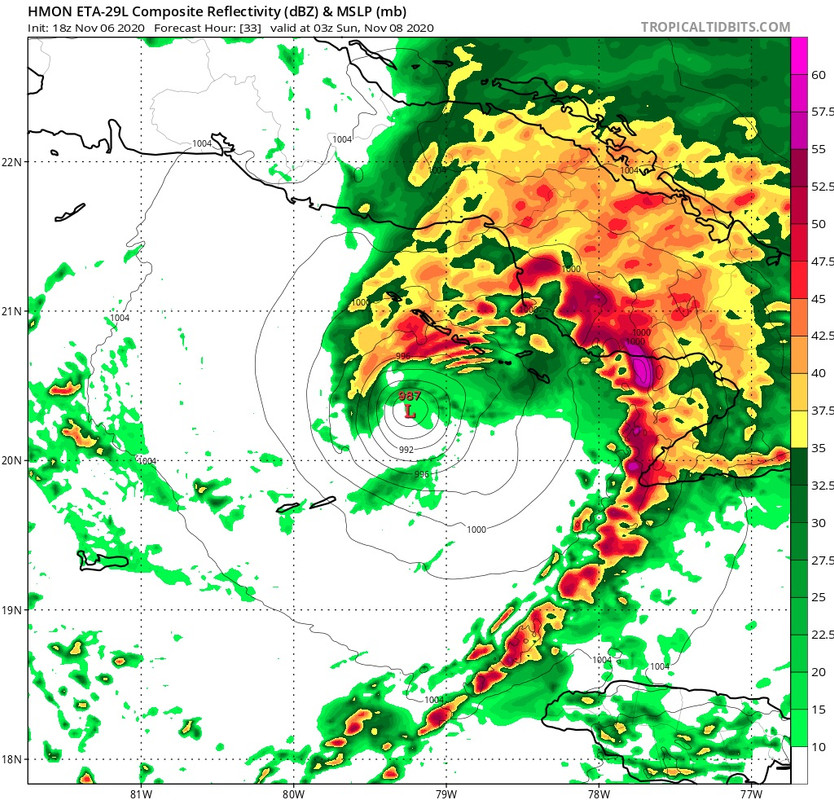
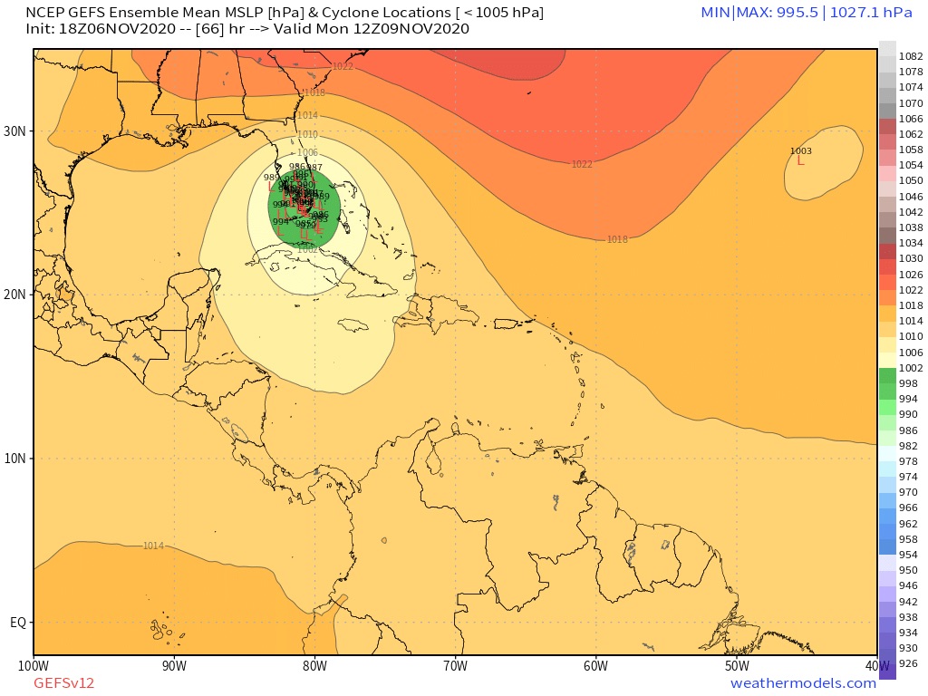
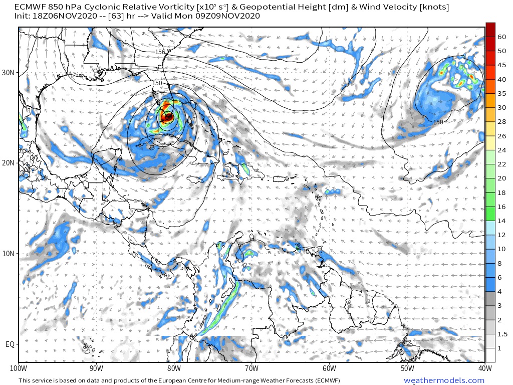
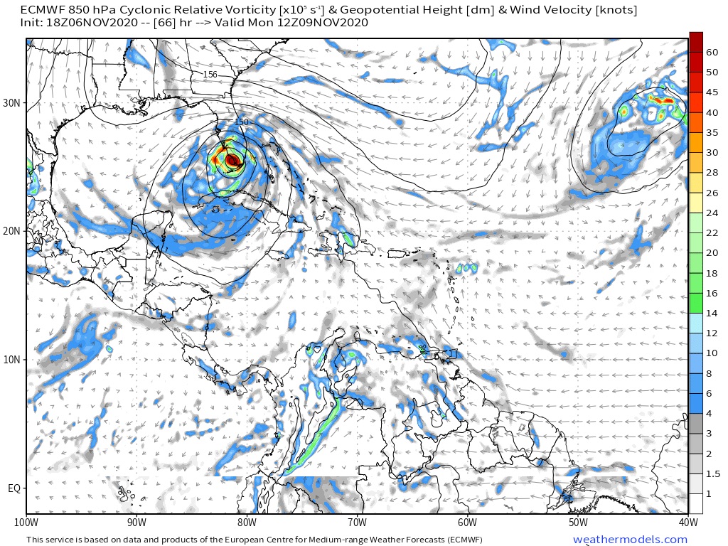
Models should shift west as a result of new initialization this evening being weaker and further west of previous forecast points. The longer it takes for any legitimate Tropical depression/storm to truly organize and have a distinct COC tracking off to the Northeast, the lesser the threat of direct impact to South Florida. Case in point: The 4:00pm update indicated Eta as a T.S. at the 07/6Z position of 18.2 & 84.8. Thus far, we essentially have an east/west broad trough with the possible center about 100 miles east of Belize. Let's see if we actually have a bonafide T.S. just to the west of the Cayman Islands later tonight around 1:00 a.m.
1 likes   
Andy D

(For official information, please refer to the NHC and NWS products.)

User avatar
SFLcane
S2K Supporter
S2K Supporter
Posts: 10163
Age: 47
Joined: Sat Jun 05, 2010 1:44 pm
Location: Lake Worth Florida

Re: ATL: ETA - Models

#1482 Postby SFLcane » Fri Nov 06, 2020 5:43 pm

18z hwrf is stronger through 18hrs... let’s see what the rest of the run shows
0 likes   

User avatar
SFLcane
S2K Supporter
S2K Supporter
Posts: 10163
Age: 47
Joined: Sat Jun 05, 2010 1:44 pm
Location: Lake Worth Florida

Re: ATL: ETA - Models

#1483 Postby SFLcane » Fri Nov 06, 2020 5:49 pm

18z Hmon is also stronger hurricane strength approaching Cuba.

Image
1 likes   

User avatar
toad strangler
S2K Supporter
S2K Supporter
Posts: 4543
Joined: Sun Jul 28, 2013 3:09 pm
Location: Earth
Contact:

Re: ATL: ETA - Models

#1484 Postby toad strangler » Fri Nov 06, 2020 5:53 pm

SFLcane wrote:18z Hmon is also stronger hurricane strength approaching Cuba.

https://i.postimg.cc/YCHTJmH4/EAA0-E168-F8-AF-4087-9-D0-A-DED5106111-AB.jpg


Structure is consistently showing no convection on the S and SW sides.
0 likes   

User avatar
SFLcane
S2K Supporter
S2K Supporter
Posts: 10163
Age: 47
Joined: Sat Jun 05, 2010 1:44 pm
Location: Lake Worth Florida

Re: ATL: ETA - Models

#1485 Postby SFLcane » Fri Nov 06, 2020 6:03 pm

Image
0 likes   

User avatar
Blown Away
S2K Supporter
S2K Supporter
Posts: 10145
Joined: Wed May 26, 2004 6:17 am

Re: ATL: ETA - Models

#1486 Postby Blown Away » Fri Nov 06, 2020 6:15 pm

18z GFS/HWRF/HMON all have strong TS/Cat 1 into SFL east coast ranging from Homestead to WPB... No worries the only model that truly matters is the Euro... :D
0 likes   
Hurricane Eye Experience: David 79, Irene 99, Frances 04, Jeanne 04, Wilma 05... EYE COMING MY WAY IN 2024…
Hurricane Brush Experience: Andrew 92, Erin 95, Floyd 99, Matthew 16, Irma 17, Ian 22, Nicole 22…

User avatar
SFLcane
S2K Supporter
S2K Supporter
Posts: 10163
Age: 47
Joined: Sat Jun 05, 2010 1:44 pm
Location: Lake Worth Florida

Re: ATL: ETA - Models

#1487 Postby SFLcane » Fri Nov 06, 2020 6:42 pm

Image
1 likes   

Loveweather12
Tropical Storm
Tropical Storm
Posts: 136
Joined: Thu Aug 20, 2020 2:37 pm

Re: ATL: ETA - Models

#1488 Postby Loveweather12 » Fri Nov 06, 2020 6:45 pm

Blown Away wrote:18z GFS/HWRF/HMON all have strong TS/Cat 1 into SFL east coast ranging from Homestead to WPB... No worries the only model that truly matters is the Euro... :D

Not true
0 likes   

TheStormExpert

Re: ATL: ETA - Models

#1489 Postby TheStormExpert » Fri Nov 06, 2020 6:45 pm

0 likes   

User avatar
SFLcane
S2K Supporter
S2K Supporter
Posts: 10163
Age: 47
Joined: Sat Jun 05, 2010 1:44 pm
Location: Lake Worth Florida

Re: ATL: ETA - Models

#1490 Postby SFLcane » Fri Nov 06, 2020 6:50 pm

TheStormExpert wrote:

That’s north of 12z GEFS. :eek:


Yep
0 likes   

Cat5James
Category 1
Category 1
Posts: 417
Joined: Fri Sep 06, 2019 7:54 pm

Re: ATL: ETA - Models

#1491 Postby Cat5James » Fri Nov 06, 2020 7:01 pm

Does anyone have the 18Z Euro?
0 likes   

User avatar
SFLcane
S2K Supporter
S2K Supporter
Posts: 10163
Age: 47
Joined: Sat Jun 05, 2010 1:44 pm
Location: Lake Worth Florida

Re: ATL: ETA - Models

#1492 Postby SFLcane » Fri Nov 06, 2020 7:07 pm

Cat5James wrote:Does anyone have the 18Z Euro?


Yep, it’s heading north right into SFL. :eek:

Image
2 likes   

User avatar
Gums
S2K Supporter
S2K Supporter
Posts: 170
Age: 82
Joined: Sun Oct 07, 2018 7:30 pm
Location: Niceville, FL

Re: ATL: ETA - Models

#1493 Postby Gums » Fri Nov 06, 2020 7:08 pm

Salute!

Well, models be damned but I show an approaching front by Wednesday.

If past experience is at play, then the storm should veer west as we have seen with many in the past.

Meanwhile, we Panhandle vets are hoping to enjoy our national holiday, and I can slow cook my traditional hearty beef veggie soup. Stuff freezes well for eating later in holiday season.

Gonna be an interesting week here in Baja Alabama and The Big Easy and even over by Wx57!

Gums sends...
3 likes   

User avatar
Blown Away
S2K Supporter
S2K Supporter
Posts: 10145
Joined: Wed May 26, 2004 6:17 am

Re: ATL: ETA - Models

#1494 Postby Blown Away » Fri Nov 06, 2020 7:17 pm

18z Navgem E shift with WPB landfall... NW over peninsula, slight stall near Cedar Key, then NE...
0 likes   
Hurricane Eye Experience: David 79, Irene 99, Frances 04, Jeanne 04, Wilma 05... EYE COMING MY WAY IN 2024…
Hurricane Brush Experience: Andrew 92, Erin 95, Floyd 99, Matthew 16, Irma 17, Ian 22, Nicole 22…

User avatar
Blown Away
S2K Supporter
S2K Supporter
Posts: 10145
Joined: Wed May 26, 2004 6:17 am

Re: ATL: ETA - Models

#1495 Postby Blown Away » Fri Nov 06, 2020 7:18 pm

SFLcane wrote:
Cat5James wrote:Does anyone have the 18Z Euro?


Yep, it’s heading north right into SFL. :eek:

https://i.postimg.cc/Sx5BKt0P/67687-FE0-F205-4-E34-9-BCD-23-FA3-C915-EDC.jpg


It’s news if it doesn’t go 90 degrees W in next frame... :D
0 likes   
Hurricane Eye Experience: David 79, Irene 99, Frances 04, Jeanne 04, Wilma 05... EYE COMING MY WAY IN 2024…
Hurricane Brush Experience: Andrew 92, Erin 95, Floyd 99, Matthew 16, Irma 17, Ian 22, Nicole 22…

Frank P
S2K Supporter
S2K Supporter
Posts: 2774
Joined: Fri Aug 29, 2003 10:52 am
Location: Biloxi Beach, Ms
Contact:

Re: ATL: ETA - Models

#1496 Postby Frank P » Fri Nov 06, 2020 7:20 pm

Gums wrote:Salute!

Well, models be damned but I show an approaching front by Wednesday.

If past experience is at play, then the storm should veer west as we have seen with many in the past.

Meanwhile, we Panhandle vets are hoping to enjoy our national holiday, and I can slow cook my traditional hearty beef veggie soup. Stuff freezes well for eating later in holiday season.

Gonna be an interesting week here in Baja Alabama and The Big Easy and even over by Wx57!

Gums sends...

If there is an approaching front why would the storm veer west? I would think the storm would veer to the east? Usually approaching fronts shunt GOM storms to the east, not west? Do explain please, grazie..
0 likes   

User avatar
SFLcane
S2K Supporter
S2K Supporter
Posts: 10163
Age: 47
Joined: Sat Jun 05, 2010 1:44 pm
Location: Lake Worth Florida

Re: ATL: ETA - Models

#1497 Postby SFLcane » Fri Nov 06, 2020 7:21 pm

Blown Away wrote:
SFLcane wrote:
Cat5James wrote:Does anyone have the 18Z Euro?


Yep, it’s heading north right into SFL. :eek:

https://i.postimg.cc/Sx5BKt0P/67687-FE0-F205-4-E34-9-BCD-23-FA3-C915-EDC.jpg


It’s news if it doesn’t go 90 degrees W in next frame... :D


Heads nw across southeast Florida before heading into the GOM. Either way you slice this it’s north of nhc forecast

Image
0 likes   

Cat5James
Category 1
Category 1
Posts: 417
Joined: Fri Sep 06, 2019 7:54 pm

Re: ATL: ETA - Models

#1498 Postby Cat5James » Fri Nov 06, 2020 7:27 pm

If I’m not mistaken every 18Z model has shown a landfall on the peninsula... track update coming at 10 pm?
0 likes   

User avatar
MetroMike
Category 4
Category 4
Posts: 952
Joined: Sun Aug 29, 2004 8:13 pm
Location: Tampa Bay
Contact:

Re: ATL: ETA - Models

#1499 Postby MetroMike » Fri Nov 06, 2020 7:35 pm

Cat5James wrote:If I’m not mistaken every 18Z model has shown a landfall on the peninsula... track update coming at 10 pm?

NHC is not taking the GFS seriously without explanation.
0 likes   

User avatar
robbielyn
Category 5
Category 5
Posts: 1298
Joined: Wed May 07, 2003 9:45 am
Location: brooksville, fl

Re: ATL: ETA - Models

#1500 Postby robbielyn » Fri Nov 06, 2020 7:39 pm

Levi’s video is out. tropicaltidbits.com synopsis dry air will wrap in the inner core and be a hybrid, cross cuba before hitting florida could build thunderstorms again in the inner core producing up to 80mph hurricane or if dry air disrupts the core again, it will remain hybrid and produce 60mph.
2 likes   
Robbielyn McCrary
I know just about enough to sound like I know what I'm talking about sometimes. But for your safety please follow the nhc for truly professional forecasting. :D


Return to “2020”

Who is online

Users browsing this forum: No registered users and 11 guests