2020 Global Model Runs Discussion (Out thru day 16)
Moderator: S2k Moderators
Forum rules
The posts in this forum are NOT official forecasts and should not be used as such. They are just the opinion of the poster and may or may not be backed by sound meteorological data. They are NOT endorsed by any professional institution or STORM2K. For official information, please refer to products from the National Hurricane Center and National Weather Service.
Re: 2020 Global Model Runs Discussion (Out thru day 16)
12z GFS has a November Greek Parade for the next two weeks. After Eta, it develops three new storms:
-Theta in the subtropical Atlantic within the next 4-7 days (has appeared on multiple other runs)
-Iota near the Lesser Antilles from a tropical wave next week
-Kappa in the Caribbean potentially starting as early as late next week (this is the Caribbean system the ensembles, GFS-Para, and ICON are showing)
8 likes
Irene '11 Sandy '12 Hermine '16 5/15/2018 Derecho Fay '20 Isaias '20 Elsa '21 Henri '21 Ida '21
I am only a meteorology enthusiast who knows a decent amount about tropical cyclones. Look to the professional mets, the NHC, or your local weather office for the best information.
- SouthFLTropics
- Category 5
- Posts: 4156
- Age: 48
- Joined: Thu Aug 14, 2003 8:04 am
- Location: Port St. Lucie, Florida
Re: 2020 Global Model Runs Discussion (Out thru day 16)
Long Range GFS... Like a bad top 40 radio station. The hits just keep on coming!!!
2 likes
Fourth Generation Floridian...With lots of storm knowledge passed down from my elders...
Personal Storm History: David 79, Andrew 92, Erin 95, Floyd 99, Irene 99, Frances 04, Jeanne 04, Wilma 05, Matthew 16, Irma 17
Re: 2020 Global Model Runs Discussion (Out thru day 16)
The 12z ICON really likes Theta, and it develops the Caribbean system quicker (which will get the name Iota because the LA/MDR system doesn't form).
0 likes
Irene '11 Sandy '12 Hermine '16 5/15/2018 Derecho Fay '20 Isaias '20 Elsa '21 Henri '21 Ida '21
I am only a meteorology enthusiast who knows a decent amount about tropical cyclones. Look to the professional mets, the NHC, or your local weather office for the best information.
- TheStormExpert
- Category 5
- Posts: 8487
- Age: 30
- Joined: Wed Feb 16, 2011 5:38 pm
- Location: Palm Beach Gardens, FL
Re: 2020 Global Model Runs Discussion (Out thru day 16)
This 500mb steering pattern is something you’d expect to see in August or September not November with a strong Bermuda High parked just NE of Bermuda steering anything west and west-northwest towards the U.S., Caribbean, and Central America.
https://twitter.com/crownweather/status/1324395865520427009
https://twitter.com/hurricanemanwx/status/1324398793677279232
https://twitter.com/crownweather/status/1324395865520427009
https://twitter.com/hurricanemanwx/status/1324398793677279232
0 likes
The following post is NOT an official forecast and should not be used as such. It is just the opinion of the poster and may or may not be backed by sound meteorological data. It is NOT endorsed by storm2k.org.
- CyclonicFury
- Category 5
- Posts: 1977
- Age: 25
- Joined: Sun Jul 02, 2017 12:32 pm
- Location: NC
- Contact:
Re: 2020 Global Model Runs Discussion (Out thru day 16)
12z ECMWF has a broad area of low pressure over the SW Caribbean at the end of the run. Considering the ECMWF model has been very poor with predicting genesis outside the very short range, and the GFS/GEFS/ICON/CMC are already picking up on something, it may be yet another Caribbean system to watch. Here we go again...
2 likes
NCSU B.S. in Meteorology Class of 2021. Tropical weather blogger at http://www.cyclonicfury.com. My forecasts and thoughts are NOT official, for official forecasts please consult the National Hurricane Center.
Re: 2020 Global Model Runs Discussion (Out thru day 16)
CyclonicFury wrote:12z ECMWF has a broad area of low pressure over the SW Caribbean at the end of the run. Considering the ECMWF model has been very poor with predicting genesis outside the very short range, and the GFS/GEFS/ICON/CMC are already picking up on something, it may be yet another Caribbean system to watch. Here we go again...
This is following the same model trends as Gamma, Delta, Zeta, and Eta. All we need is the models to suddenly drop it in the medium-range before picking it back up again after 2-4 days.
I believe this system, which I’ll call “Future Iota” (since a subtropical system will likely become Theta), is also going to be AEW-based like Delta and Eta.
4 likes
Irene '11 Sandy '12 Hermine '16 5/15/2018 Derecho Fay '20 Isaias '20 Elsa '21 Henri '21 Ida '21
I am only a meteorology enthusiast who knows a decent amount about tropical cyclones. Look to the professional mets, the NHC, or your local weather office for the best information.
Re: 2020 Global Model Runs Discussion (Out thru day 16)
The GFS-Para and CMC start developing future Iota in the central Caribbean as early as the second half of next week. Meanwhile, the GFS is getting this strung out and intertwined with a system forming to the NE of the Antilles, and the Euro is still showing a broad low in the SWCar in 8-10 days.
0 likes
Irene '11 Sandy '12 Hermine '16 5/15/2018 Derecho Fay '20 Isaias '20 Elsa '21 Henri '21 Ida '21
I am only a meteorology enthusiast who knows a decent amount about tropical cyclones. Look to the professional mets, the NHC, or your local weather office for the best information.
Re: 2020 Global Model Runs Discussion (Out thru day 16)
Today’s 12z GFS still has several more storms in the next 10 days: Theta in the subtropical eastern Atlantic (as well as another TD), Iota NE of the Antilles, and Kappa in the western Caribbean.
0 likes
Irene '11 Sandy '12 Hermine '16 5/15/2018 Derecho Fay '20 Isaias '20 Elsa '21 Henri '21 Ida '21
I am only a meteorology enthusiast who knows a decent amount about tropical cyclones. Look to the professional mets, the NHC, or your local weather office for the best information.
Re: 2020 Global Model Runs Discussion (Out thru day 16)
12Z King: check out the SW Caribbean!
0 likes
Personal Forecast Disclaimer:
The posts in this forum are NOT official forecasts and should not be used as such. They are just the opinion of the poster and may or may not be backed by sound meteorological data. They are NOT endorsed by any professional institution or storm2k.org. For official information, please refer to the NHC and NWS products.
Re: 2020 Global Model Runs Discussion (Out thru day 16)
12Z EPS: still pretty active, especially for the EPS!
1 likes
Personal Forecast Disclaimer:
The posts in this forum are NOT official forecasts and should not be used as such. They are just the opinion of the poster and may or may not be backed by sound meteorological data. They are NOT endorsed by any professional institution or storm2k.org. For official information, please refer to the NHC and NWS products.
-
- Category 5
- Posts: 3950
- Age: 27
- Joined: Mon Aug 17, 2015 4:16 pm
- Location: Ft. Lauderdale, Florida
Re: 2020 Global Model Runs Discussion (Out thru day 16)
LarryWx wrote:12Z EPS: still pretty active, especially for the EPS!
https://i.imgur.com/pjSp8zv.png
Please, no more. I'm done with 2020.
I just want my Turkey and Christmas gifts.
1 likes
The posts in this forum are NOT official forecasts and should not be used as such. They are just the opinion of the poster and may or may not be backed by sound meteorological data. They are NOT endorsed by any professional institution or STORM2K. For official information, please refer to products from the NHC and NWS.
Model Runs Cheat Sheet:
GFS (5:30 AM/PM, 11:30 AM/PM)
HWRF, GFDL, UKMET, NAVGEM (6:30-8:00 AM/PM, 12:30-2:00 AM/PM)
ECMWF (1:45 AM/PM)
TCVN is a weighted averaged
Re: 2020 Global Model Runs Discussion (Out thru day 16)
AutoPenalti wrote:LarryWx wrote:12Z EPS: still pretty active, especially for the EPS!
https://i.imgur.com/pjSp8zv.png
Please, no more. I'm done with 2020.
I just want my Turkey and Christmas gifts.
I don't believe you.
Hurricane lovers would have them all year round if they had their wayl Why would they ever want them to stop? Of course, I may be wrong to assume you love tracking these things, but most active posters here obviously do or they wouldn't be actively posting.
2 likes
Personal Forecast Disclaimer:
The posts in this forum are NOT official forecasts and should not be used as such. They are just the opinion of the poster and may or may not be backed by sound meteorological data. They are NOT endorsed by any professional institution or storm2k.org. For official information, please refer to the NHC and NWS products.
-
- Category 5
- Posts: 3950
- Age: 27
- Joined: Mon Aug 17, 2015 4:16 pm
- Location: Ft. Lauderdale, Florida
Re: 2020 Global Model Runs Discussion (Out thru day 16)
LarryWx wrote:AutoPenalti wrote:LarryWx wrote:12Z EPS: still pretty active, especially for the EPS!
https://i.imgur.com/pjSp8zv.png
Please, no more. I'm done with 2020.
I just want my Turkey and Christmas gifts.
I don't believe you.
Hurricane lovers would have them all year round if they had their wayl Why would they ever want them to stop? Of course, I may be wrong to assume you love tracking these things, but most active posters here obviously do or they wouldn't be actively posting.
Oh trust me I love tracking hurricanes.
But I also want to spend my New Year’s eve with a Champagne bottle and not trying to have my eyes glued to the GFS and Euro with impeding Hurricane Mu on my doorstep.
8 likes
The posts in this forum are NOT official forecasts and should not be used as such. They are just the opinion of the poster and may or may not be backed by sound meteorological data. They are NOT endorsed by any professional institution or STORM2K. For official information, please refer to products from the NHC and NWS.
Model Runs Cheat Sheet:
GFS (5:30 AM/PM, 11:30 AM/PM)
HWRF, GFDL, UKMET, NAVGEM (6:30-8:00 AM/PM, 12:30-2:00 AM/PM)
ECMWF (1:45 AM/PM)
TCVN is a weighted averaged
- gatorcane
- S2K Supporter
- Posts: 23499
- Age: 46
- Joined: Sun Mar 13, 2005 3:54 pm
- Location: Boca Raton, FL
Re: 2020 Global Model Runs Discussion (Out thru day 16)
I know this is fantasy land but what?!?
1 likes
Re: 2020 Global Model Runs Discussion (Out thru day 16)
gatorcane wrote:I know this is fantasy land but what?!?
https://i.postimg.cc/NFgszRZH/gfs-mslpa-Norm-watl-fh300-384.gif
Is there any precedent for this kind of activity and pattern in November? I know its a la nina pattern but its unusually favorable in the Caribbean. This looks like the 3rd peak of season.
0 likes
- AnnularCane
- S2K Supporter
- Posts: 2658
- Joined: Thu Jun 08, 2006 9:18 am
- Location: Wytheville, VA
Re: 2020 Global Model Runs Discussion (Out thru day 16)
gatorcane wrote:I know this is fantasy land but what?!?
https://i.postimg.cc/NFgszRZH/gfs-mslpa-Norm-watl-fh300-384.gif
Is there any precedent for this kind of activity and pattern in November? I know its a la nina pattern but its unusually favorable in the Caribbean. This looks like the 3rd peak of season.
0 likes
Re: 2020 Global Model Runs Discussion (Out thru day 16)
AnnularCane wrote:Andrew in November?
I mean, we just had a T#8.5 Felix-Mitch crossover in November...anything is possible I guess.
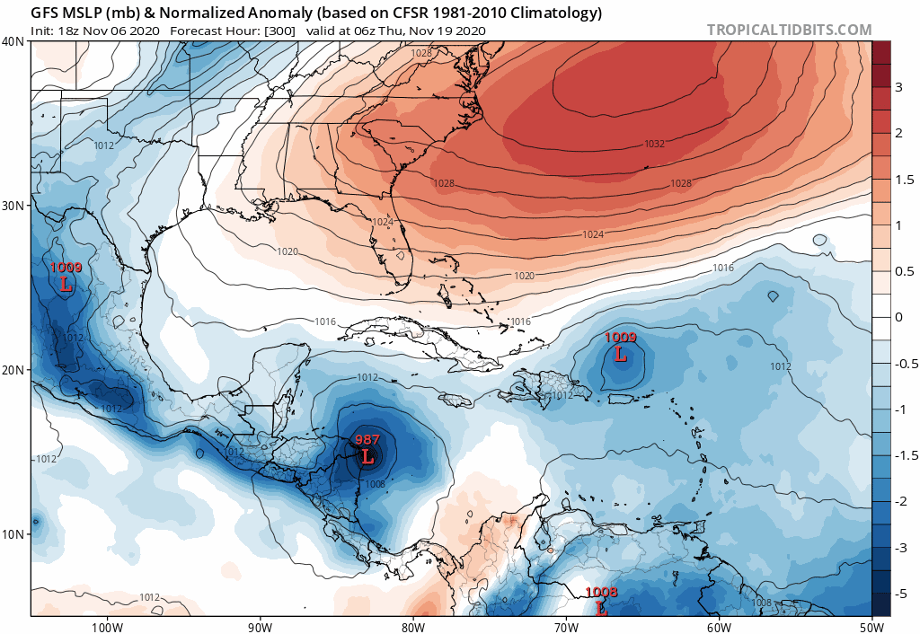
Now that development is coming in closer, all of the models show something in the WCar. The GFS, GFS-Para, CMC, and ICON all show a TC, while the Euro and NAVGEM show the precursor. I think this one will also have a chance to explode because the Caribbean, especially the NWCar, is STILL a powder keg of hurricane fuel even this late in the year. The NWCar has warm enough SSTs and OHC to support a sub-900 mbar Category 5. All it takes is a Delta-like track, and a moist/low shear environment, and the 2020 drive will kick right in.
0 likes
Irene '11 Sandy '12 Hermine '16 5/15/2018 Derecho Fay '20 Isaias '20 Elsa '21 Henri '21 Ida '21
I am only a meteorology enthusiast who knows a decent amount about tropical cyclones. Look to the professional mets, the NHC, or your local weather office for the best information.
- TheStormExpert
- Category 5
- Posts: 8487
- Age: 30
- Joined: Wed Feb 16, 2011 5:38 pm
- Location: Palm Beach Gardens, FL
Re: 2020 Global Model Runs Discussion (Out thru day 16)
gatorcane wrote:I know this is fantasy land but what?!?
https://i.postimg.cc/NFgszRZH/gfs-mslpa-Norm-watl-fh300-384.gif
Fortunately this steering pattern never showed up in September as some feared it would.
Probably going to be a very warm winter overall here in Florida if this keeps up too long.
0 likes
The following post is NOT an official forecast and should not be used as such. It is just the opinion of the poster and may or may not be backed by sound meteorological data. It is NOT endorsed by storm2k.org.
- ElectricStorm
- Category 5
- Posts: 4625
- Age: 23
- Joined: Tue Aug 13, 2019 11:23 pm
- Location: Skiatook, OK / Norman, OK
Re: 2020 Global Model Runs Discussion (Out thru day 16)
St0rmTh0r wrote:gatorcane wrote:I know this is fantasy land but what?!?
https://i.postimg.cc/NFgszRZH/gfs-mslpa-Norm-watl-fh300-384.gif
Is there any precedent for this kind of activity and pattern in November? I know its a la nina pattern but its unusually favorable in the Caribbean. This looks like the 3rd peak of season.
1932 had a Cat 5 in the Caribbean and a Cat 2 that originated in the MDR, both in November so I guess anything's possible lol
0 likes
I am in no way a professional. Take what I say with a grain of salt as I could be totally wrong. Please refer to the NHC, NWS, or SPC for official information.
Boomer Sooner!
Boomer Sooner!
Who is online
Users browsing this forum: CourierPR, Cpv17, Killjoy12, StPeteMike and 39 guests