ATL: IOTA - Remnants - Discussion

Moderator: S2k Moderators

Message
Author
User avatar
Iceresistance
Category 5
Category 5
Posts: 9279
Age: 21
Joined: Sat Oct 10, 2020 9:45 am
Location: Tecumseh, OK/Norman, OK

Re: ATL: INVEST 98L - Discussion

#121 Postby Iceresistance » Thu Nov 12, 2020 10:08 am

kevin wrote:
Iceresistance wrote:
underthwx wrote:What sort of problems is the GFS having Ice?...

Some model times never came up, it normally happens during the run so it can update the time. But after the run, something is wrong. It either failed to update the time or it had problems updating the run.


Yes, very weird. 60 - 162 hours is still missing for 06z GFS.

42 & 48 hours is also missing :/
1 likes   
Bill 2015 & Beta 2020

Winter 2020-2021 :cold:

All observations are in Tecumseh, OK unless otherwise noted.

Winter posts are focused mainly for Oklahoma & Texas.

Take any of my forecasts with a grain of salt, refer to the NWS, SPC, and NHC for official information

Never say Never with weather! Because ANYTHING is possible!

User avatar
Iceresistance
Category 5
Category 5
Posts: 9279
Age: 21
Joined: Sat Oct 10, 2020 9:45 am
Location: Tecumseh, OK/Norman, OK

Re: ATL: INVEST 98L - Discussion

#122 Postby Iceresistance » Thu Nov 12, 2020 10:18 am

Visible is now seeable for 98L

Image
0 likes   
Bill 2015 & Beta 2020

Winter 2020-2021 :cold:

All observations are in Tecumseh, OK unless otherwise noted.

Winter posts are focused mainly for Oklahoma & Texas.

Take any of my forecasts with a grain of salt, refer to the NWS, SPC, and NHC for official information

Never say Never with weather! Because ANYTHING is possible!

User avatar
Owasso
Category 1
Category 1
Posts: 309
Joined: Sat Aug 22, 2020 11:14 pm
Location: Chicago, Illinois

Re: ATL: INVEST 98L - Discussion

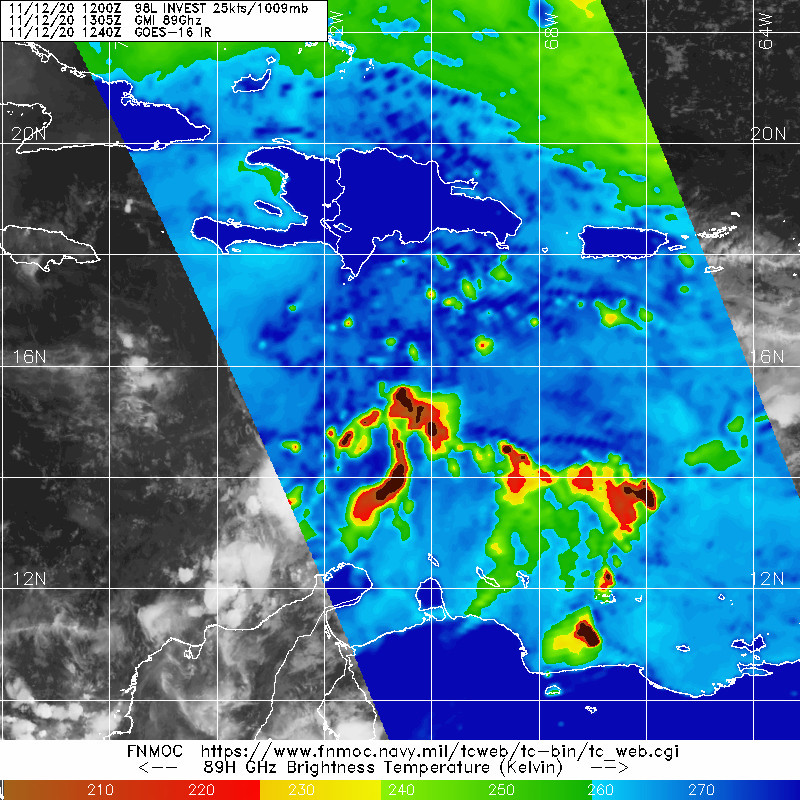
#123 Postby Owasso » Thu Nov 12, 2020 10:36 am

Image
0 likes   

User avatar
ElectricStorm
Category 5
Category 5
Posts: 5017
Age: 24
Joined: Tue Aug 13, 2019 11:23 pm
Location: Skiatook, OK / Norman, OK

Re: ATL: INVEST 98L - Discussion

#124 Postby ElectricStorm » Thu Nov 12, 2020 10:55 am

I'm thinking we could see a PTC today or tonight since it's got land in its sights
0 likes   
I am in no way a professional. Take what I say with a grain of salt as I could be totally wrong. Please refer to the NHC, NWS, or SPC for official information.

Boomer Sooner!

User avatar
Iceresistance
Category 5
Category 5
Posts: 9279
Age: 21
Joined: Sat Oct 10, 2020 9:45 am
Location: Tecumseh, OK/Norman, OK

Re: ATL: INVEST 98L - Discussion

#125 Postby Iceresistance » Thu Nov 12, 2020 11:03 am

This will be named storm #30. . . :eek:
0 likes   
Bill 2015 & Beta 2020

Winter 2020-2021 :cold:

All observations are in Tecumseh, OK unless otherwise noted.

Winter posts are focused mainly for Oklahoma & Texas.

Take any of my forecasts with a grain of salt, refer to the NWS, SPC, and NHC for official information

Never say Never with weather! Because ANYTHING is possible!

User avatar
Owasso
Category 1
Category 1
Posts: 309
Joined: Sat Aug 22, 2020 11:14 pm
Location: Chicago, Illinois

Re: ATL: INVEST 98L - Discussion

#126 Postby Owasso » Thu Nov 12, 2020 11:06 am

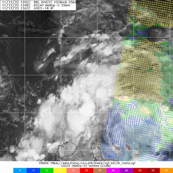
ASCAT misses

Image
0 likes   

User avatar
Iceresistance
Category 5
Category 5
Posts: 9279
Age: 21
Joined: Sat Oct 10, 2020 9:45 am
Location: Tecumseh, OK/Norman, OK

Re: ATL: INVEST 98L - Discussion

#127 Postby Iceresistance » Thu Nov 12, 2020 11:08 am


But there is a hint that the winds are near TD force inside 98L, 20 knots far east of the system
0 likes   
Bill 2015 & Beta 2020

Winter 2020-2021 :cold:

All observations are in Tecumseh, OK unless otherwise noted.

Winter posts are focused mainly for Oklahoma & Texas.

Take any of my forecasts with a grain of salt, refer to the NWS, SPC, and NHC for official information

Never say Never with weather! Because ANYTHING is possible!

jconsor
Professional-Met
Professional-Met
Posts: 547
Joined: Mon Jun 30, 2008 9:31 pm
Location: Jerusalem, Israel
Contact:

Re: ATL: INVEST 98L - Discussion

#128 Postby jconsor » Thu Nov 12, 2020 11:21 am

0 likes   

Sanibel
Category 5
Category 5
Posts: 10375
Joined: Mon Aug 30, 2004 11:06 pm
Location: Offshore SW Florida

ATL: INVEST 98L - Discussion

#129 Postby Sanibel » Thu Nov 12, 2020 11:26 am

Another no-doubter in a hyper-favorable season...
0 likes   

supercane4867
Category 5
Category 5
Posts: 4966
Joined: Wed Nov 14, 2012 10:43 am

Re: ATL: INVEST 98L - Discussion

#130 Postby supercane4867 » Thu Nov 12, 2020 11:29 am

We may get more insanely cold cloudtops from future Iota if it becomes a major...
0 likes   

User avatar
wxman57
Moderator-Pro Met
Moderator-Pro Met
Posts: 22951
Age: 67
Joined: Sat Jun 21, 2003 8:06 pm
Location: Houston, TX (southwest)

Re: ATL: INVEST 98L - Discussion

#131 Postby wxman57 » Thu Nov 12, 2020 11:30 am

Iceresistance wrote:


But there is a hint that the winds are near TD force inside 98L, 20 knots far east of the system


Depressions have no wind threshold. A tropical wave can produce 35-40 kt winds, though. Looks like THIS one is going to stay in Central America. High to the north much stronger than for Eta. Probably a TD by Saturday and a hurricane prior to landfall next Tuesday (or so). More catastrophic flooding for Honduras and Nicaragua.
6 likes   

User avatar
Iceresistance
Category 5
Category 5
Posts: 9279
Age: 21
Joined: Sat Oct 10, 2020 9:45 am
Location: Tecumseh, OK/Norman, OK

Re: ATL: INVEST 98L - Discussion

#132 Postby Iceresistance » Thu Nov 12, 2020 11:32 am

supercane4867 wrote:We may get more insanely cold cloudtops from future Iota if it becomes a major...

And an extremely warm eye . . . :eek:
0 likes   
Bill 2015 & Beta 2020

Winter 2020-2021 :cold:

All observations are in Tecumseh, OK unless otherwise noted.

Winter posts are focused mainly for Oklahoma & Texas.

Take any of my forecasts with a grain of salt, refer to the NWS, SPC, and NHC for official information

Never say Never with weather! Because ANYTHING is possible!

User avatar
Laminar
Tropical Storm
Tropical Storm
Posts: 169
Joined: Mon Sep 10, 2018 11:42 am
Location: Ambergris Caye Belize

Re: ATL: INVEST 98L - Discussion

#133 Postby Laminar » Thu Nov 12, 2020 11:34 am

wxman57 wrote:
Iceresistance wrote:


But there is a hint that the winds are near TD force inside 98L, 20 knots far east of the system


Depressions have no wind threshold. A tropical wave can produce 35-40 kt winds, though. Looks like THIS one is going to stay in Central America. High to the north much stronger than for Eta. Probably a TD by Saturday and a hurricane prior to landfall next Tuesday (or so). More catastrophic flooding for Honduras and Nicaragua.


How much chance does this have to miss the CA corner and sneak across the northern shoreline a la HWRF? How is that ridge doing?
0 likes   
FAA ATP
Belize UAS Operator

User avatar
aspen
Category 5
Category 5
Posts: 8812
Joined: Sat Oct 12, 2019 7:10 pm
Location: Connecticut, USA

Re: ATL: INVEST 98L - Discussion

#134 Postby aspen » Thu Nov 12, 2020 11:37 am


*pre-Eta flashbacks intensify*
9 likes   
Irene '11 Sandy '12 Hermine '16 5/15/2018 Derecho Fay '20 Isaias '20 Elsa '21 Henri '21 Ida '21

I am only a meteorology enthusiast who knows a decent amount about tropical cyclones. Look to the professional mets, the NHC, or your local weather office for the best information.

User avatar
Iceresistance
Category 5
Category 5
Posts: 9279
Age: 21
Joined: Sat Oct 10, 2020 9:45 am
Location: Tecumseh, OK/Norman, OK

Re: ATL: INVEST 98L - Discussion

#135 Postby Iceresistance » Thu Nov 12, 2020 11:39 am

aspen wrote:

*pre-Eta flashbacks intensify*


Where ASCAT misses Pre-Eta 6 times!
0 likes   
Bill 2015 & Beta 2020

Winter 2020-2021 :cold:

All observations are in Tecumseh, OK unless otherwise noted.

Winter posts are focused mainly for Oklahoma & Texas.

Take any of my forecasts with a grain of salt, refer to the NWS, SPC, and NHC for official information

Never say Never with weather! Because ANYTHING is possible!

User avatar
Iceresistance
Category 5
Category 5
Posts: 9279
Age: 21
Joined: Sat Oct 10, 2020 9:45 am
Location: Tecumseh, OK/Norman, OK

Re: ATL: INVEST 98L - Discussion

#136 Postby Iceresistance » Thu Nov 12, 2020 11:54 am

There is no dry air in the Western Caribbean, the only inhibitor is wind shear, and it's very low ahead of 98L!


Image
2 likes   
Bill 2015 & Beta 2020

Winter 2020-2021 :cold:

All observations are in Tecumseh, OK unless otherwise noted.

Winter posts are focused mainly for Oklahoma & Texas.

Take any of my forecasts with a grain of salt, refer to the NWS, SPC, and NHC for official information

Never say Never with weather! Because ANYTHING is possible!

underthwx
Category 5
Category 5
Posts: 2351
Joined: Sat Jul 30, 2011 2:14 pm
Location: Brazoria County Texas

Re: ATL: INVEST 98L - Discussion

#137 Postby underthwx » Thu Nov 12, 2020 11:57 am

Iceresistance wrote:There is no dry air in the Western Caribbean, the only inhibitor is wind shear, and it's very low ahead of 98L!


https://s8.gifyu.com/images/98L-Water-Vapor.gif

Those conditions may allow 98L to be a strong system I would imagine...
0 likes   

User avatar
Iceresistance
Category 5
Category 5
Posts: 9279
Age: 21
Joined: Sat Oct 10, 2020 9:45 am
Location: Tecumseh, OK/Norman, OK

Re: ATL: INVEST 98L - Discussion

#138 Postby Iceresistance » Thu Nov 12, 2020 12:02 pm

The wind shear data is currently missing, what is the latest wind shear levels over 98L?
0 likes   
Bill 2015 & Beta 2020

Winter 2020-2021 :cold:

All observations are in Tecumseh, OK unless otherwise noted.

Winter posts are focused mainly for Oklahoma & Texas.

Take any of my forecasts with a grain of salt, refer to the NWS, SPC, and NHC for official information

Never say Never with weather! Because ANYTHING is possible!

underthwx
Category 5
Category 5
Posts: 2351
Joined: Sat Jul 30, 2011 2:14 pm
Location: Brazoria County Texas

Re: ATL: INVEST 98L - Discussion

#139 Postby underthwx » Thu Nov 12, 2020 12:03 pm

wxman57 wrote:
Iceresistance wrote:


But there is a hint that the winds are near TD force inside 98L, 20 knots far east of the system


Depressions have no wind threshold. A tropical wave can produce 35-40 kt winds, though. Looks like THIS one is going to stay in Central America. High to the north much stronger than for Eta. Probably a TD by Saturday and a hurricane prior to landfall next Tuesday (or so). More catastrophic flooding for Honduras and Nicaragua.

That is exactly what Nicaragua and Honduras do not need...if whatever form 98L tracks to Central America...with the stronger high pressure to the north...will that force it into the EPAC, If it holds together?...I realize it's early in the forecast period to determine that, assuming it landfalls as a hurricane...
1 likes   

User avatar
Iceresistance
Category 5
Category 5
Posts: 9279
Age: 21
Joined: Sat Oct 10, 2020 9:45 am
Location: Tecumseh, OK/Norman, OK

Re: ATL: INVEST 98L - Discussion

#140 Postby Iceresistance » Thu Nov 12, 2020 12:08 pm

There is a trough with the southern end over Puerto Rico, will that make 98L move more north?
0 likes   
Bill 2015 & Beta 2020

Winter 2020-2021 :cold:

All observations are in Tecumseh, OK unless otherwise noted.

Winter posts are focused mainly for Oklahoma & Texas.

Take any of my forecasts with a grain of salt, refer to the NWS, SPC, and NHC for official information

Never say Never with weather! Because ANYTHING is possible!


Return to “2020”

Who is online

Users browsing this forum: No registered users and 4 guests