...EXTREMELY DANGEROUS IOTA MOVING ACROSS NORTHEASTERN NICARAGUA...
...LIFE-THREATENING STORM SURGE, CATASTROPHIC WINDS, FLASH FLOODING,
AND LANDSLIDES EXPECTED ACROSS PORTIONS OF CENTRAL AMERICA...
SUMMARY OF 100 AM EST...0600 UTC...INFORMATION
----------------------------------------------
LOCATION...13.7N 83.9W
ABOUT 40 MI...60 KM SW OF PUERTO CABEZAS NICARAGUA
ABOUT 105 MI...165 KM SSW OF CABO GRACIAS A DIOS ON NIC/HON BORDER
MAXIMUM SUSTAINED WINDS...130 MPH...210 KM/H
PRESENT MOVEMENT...W OR 275 DEGREES AT 9 MPH...15 KM/H
MINIMUM CENTRAL PRESSURE...935 MB...27.61 INCHES
ATL: IOTA - Remnants - Discussion
Moderator: S2k Moderators
-
ElectricStorm

- Category 5

- Posts: 5139
- Age: 25
- Joined: Tue Aug 13, 2019 11:23 pm
- Location: Norman, OK
Re: ATL: IOTA - Hurricane - Discussion
0 likes
B.S Meteorology, University of Oklahoma '25
Please refer to the NHC, NWS, or SPC for official information.
Please refer to the NHC, NWS, or SPC for official information.
-
CrazyC83
- Professional-Met

- Posts: 34315
- Joined: Tue Mar 07, 2006 11:57 pm
- Location: Deep South, for the first time!
Re: ATL: IOTA - Hurricane - Discussion
It's mostly jungle right now where Iota is, so we likely won't get any core measurements. There are a few communities about 50-75 miles inland though. Most of Nicaragua's population is in the mountainous regions and on the Pacific side, so while the wind damage may not be as big of an issue, the flooding (especially from rainfall) certainly will be.
3 likes
Re: ATL: IOTA - Hurricane - Discussion
The storm rages on....I don't know about yall.... but im ready for some of them blue skies for a change...It's quiet here .. think im gonna join yall.... and crash..... Goodnight Ice.... And all y'all!
0 likes

Re: ATL: IOTA - Hurricane - Discussion
If Iota remained a CAT 5 at landfall, it would have broken the record for latest Atlantic CAT 5 landfall by almost a month. The current record is held by the 1924 Cuban Hurricane which struck western Cuba as at CAT 5 on October 19. Thankfully, Iota wasn't quite as strong at landfall but still very dangerous. Hope Central America is pulling through.
0 likes
-
SouthernBreeze

- Category 1

- Posts: 284
- Age: 69
- Joined: Tue Aug 31, 2004 4:54 pm
- Location: SC/NC line- on the SC Coast
Re: ATL: IOTA - Hurricane - Discussion
From NHC 4 AM disco -
Due to the previous damage caused by Eta, wind reports have been
extremely limited. There was an amateur radio report from Club de
Radio-Experimentadores de Nicaragua of 124 mph (200 Km/h) winds and
roofs damaged in the town of Wilbi, Nicaragua. However, it is
uncertain if these were sustained winds or wind gusts. At the Puerto
Cabezas, Nicaragua, airport at 0253 UTC, a sustained wind of 72 kt
(134 km/h) and a gust to 98 kt (182 km/h) were measured. The initial
intensity of 90 kt is based on the Decay-SHIPS model's weakening
rate for inland tropical cyclones, and the remnant eye feature
still noted in infrared satellite imagery.
0 likes
My posts are NOT official forecast and should not be used as such. It's just my opinion and not backed by sound meteorological data, and NOT endorsed by any professional institution or storm2k.org. For official information, please refer to the NHC and NWS products.
grazed by many - most wind damage: Hugo (pre-cellphone days!) & most water: Floyd
grazed by many - most wind damage: Hugo (pre-cellphone days!) & most water: Floyd

-
wxman57

- Moderator-Pro Met

- Posts: 23172
- Age: 68
- Joined: Sat Jun 21, 2003 8:06 pm
- Location: Houston, TX (southwest)
Re: ATL: IOTA - Hurricane - Discussion
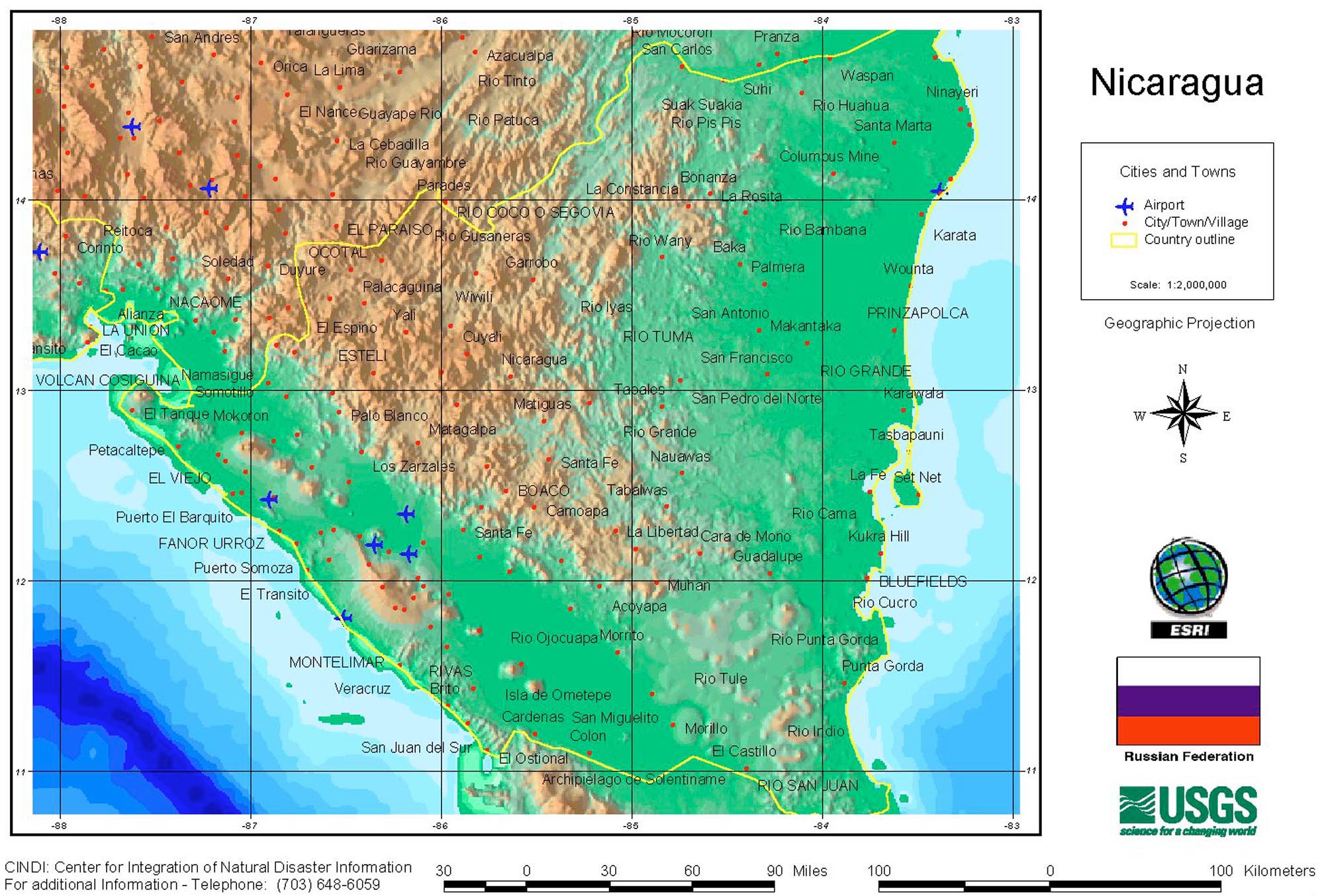
Iota's center has now reached the mountains of western Nicaragua. Typically, a strong hurricane will lose half its intensity in 11 1/2 hours over land (flat land). Max winds are likely down to 55-60 kts now (possibly lower). The center will be fully over mountains by this afternoon, which should quickly weaken it to a remnant low. The threat is shifting from wind to very heavy rainfall today.
https://legacy.lib.utexas.edu/maps/americas/nicaragua_cindi98.jpg
https://legacy.lib.utexas.edu/maps/americas/nicaragua_cindi98.jpg
4 likes
Re: ATL: IOTA - Hurricane - Discussion
The 18z best track point yesterday was revised down to 135 kt, which seems like the right call based on what recon was reporting through the day. 12z remains 140 kt.
5 likes
Re: ATL: IOTA - Hurricane - Discussion
wxman57 wrote:Iota's center has now reached the mountains of western Nicaragua. Typically, a strong hurricane will lose half its intensity in 11 1/2 hours over land (flat land). Max winds are likely down to 55-60 kts now (possibly lower). The center will be fully over mountains by this afternoon, which should quickly weaken it to a remnant low. The threat is shifting from wind to very heavy rainfall today.
https://legacy.lib.utexas.edu/maps/americas/nicaragua_cindi98.jpg
That's terrible for them...what a disaster
0 likes
-
alanstover
- Tropical Low

- Posts: 46
- Joined: Mon Jun 28, 2010 8:40 pm
- Location: Quetzaltenango, Guatemala, CA
Re: ATL: IOTA - Hurricane - Discussion
Is there any readily accessible data on current rainfall rates or accumulative rainfall for Central America?
Thanks.
Thanks.
0 likes
Re: ATL: IOTA - Hurricane - Discussion
us89 wrote:The 18z best track point yesterday was revised down to 135 kt, which seems like the right call based on what recon was reporting through the day. 12z remains 140 kt.
Not surprised at all to hear this. I made the comment last night after the 0z intermediate advisory that the would likely bump that down to Cat 4 and probably 18z as well. I knew they’d keep 12z as Cat 5 because that’s obviously when we got the strongest recon data.
0 likes


Re: ATL: IOTA - Hurricane - Discussion
alanstover wrote:Is there any readily accessible data on current rainfall rates or accumulative rainfall for Central America?
Thanks.
Probably epic. I hope these people got away from the coast.
https://twitter.com/Ginger_Zee/status/1 ... 7084478464
Major flooding along the Ochomogo river in Rivas.
https://www.laprensa.com.ni/nacionales
Here are live updates.
https://www.laprensa.com.ni/2020/11/17/ ... -nicaragua
0 likes
The following post is NOT an official forecast and should not be used as such. It is just the opinion of the poster and may or may not be backed by sound meteorological data. It is NOT endorsed by any professional institution including storm2k.org For Official Information please refer to the NHC and NWS products.
Re: ATL: IOTA - Hurricane - Discussion
...POTENTIALLY CATASTROPHIC FLASH FLOODING AND MUDSLIDES ACROSS PORTIONS OF CENTRAL AMERICA POSSIBLE FROM IOTA THROUGH THURSDAY...
12:00 PM CST Tue Nov 17
Location: 13.7°N 85.7°W
Moving: W at 12 mph
Min pressure: 988 mb
Max sustained: 65 mph
12:00 PM CST Tue Nov 17
Location: 13.7°N 85.7°W
Moving: W at 12 mph
Min pressure: 988 mb
Max sustained: 65 mph
0 likes

Re: ATL: IOTA - Tropical Storm - Discussion
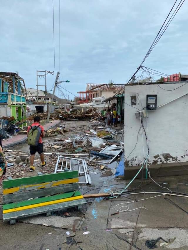
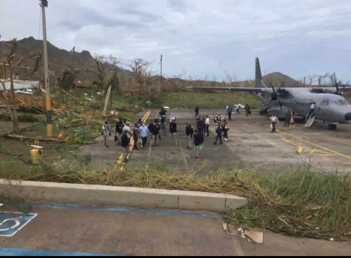
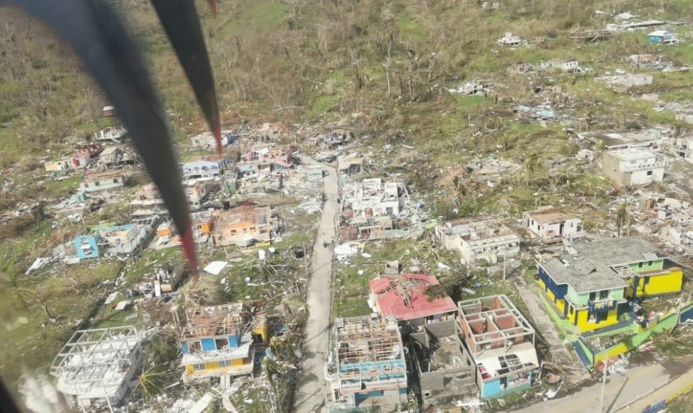
These are images of Providencia, Colombia after Iota.
2 likes
Re: ATL: IOTA - Tropical Storm - Discussion
xMarcel wrote:These are images of Providencia, Colombia after Iota.
https://pbs.twimg.com/media/EnDbpq5XMAEdWCL?format=jpg&name=900x900
https://pbs.twimg.com/media/EnDPUHOXUAYsDjp?format=jpg&name=900x900
https://pbs.twimg.com/media/EnDNsiHW8AAME8i?format=jpg&name=medium
That is awful, I feel terrible for that community...
0 likes
-
bob rulz
- Category 5
- Posts: 1711
- Age: 35
- Joined: Sat Jan 28, 2006 7:30 pm
- Location: Salt Lake City, Utah
Re: ATL: IOTA - Tropical Storm - Discussion
Wow. That reminds me a lot of what Dominica looked like after Maria.
0 likes

Re: ATL: IOTA - Tropical Storm - Discussion
bob rulz wrote:Wow. That reminds me a lot of what Dominica looked like after Maria.
It’s also what St Maarten looked like after Irma.
I am feeling for those people.
So sad. So much destruction.
5 likes
Too many hurricanes to remember
-
cycloneye

- Admin

- Posts: 149275
- Age: 69
- Joined: Thu Oct 10, 2002 10:54 am
- Location: San Juan, Puerto Rico
Re: ATL: IOTA - Tropical Storm - Discussion
Those images revive my memory of what happened in Puerto Rico after Maria strucked.
3 likes
Visit the Caribbean-Central America Weather Thread where you can find at first post web cams,radars
and observations from Caribbean basin members Click Here
and observations from Caribbean basin members Click Here
Re: ATL: IOTA - Tropical Storm - Discussion
cycloneye wrote:Those images revive my memory of what happened in Puerto Rico after Maria strucked.
A bad memory at that CE...bless ya brother...
0 likes

Re: ATL: IOTA - Tropical Storm - Discussion
I can imagine the death toll is going to be high on top of COVID-19 pandemic. 

0 likes
Who is online
Users browsing this forum: No registered users and 204 guests