

Mesoscale Discussion 1808
NWS Storm Prediction Center Norman OK
0517 PM CST Tue Nov 24 2020
Areas affected...Portions of southern Kansas...central
Oklahoma...north-central Texas
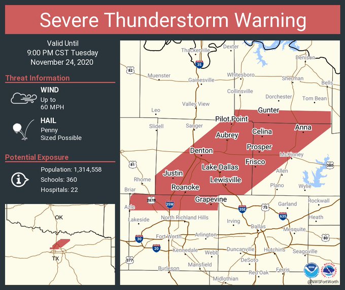
Concerning...Severe Thunderstorm Watch 513...
Valid 242317Z - 250115Z
The severe weather threat for Severe Thunderstorm Watch 513
continues.
SUMMARY...The severe threat is expected to continue across Severe
Thunderstorm Watch 0513. Additional isolated severe thunderstorms
may develop just north/east of the watch in southern Kansas into
eastern Oklahoma as well as into northern Texas. Large hail,
damaging gusts, and perhaps a tornado cannot be ruled out with the
stronger storms. An additional WW may be needed downstream.
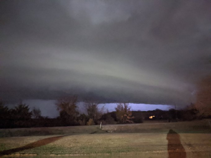
DISCUSSION...Quasi-discrete convection has grown upscale into a more
continuous linear segment along a cold front, aligned roughly from
AVK to CLK. More isolated cellular development, with an uptick in
lightning flash rates and echo tops exceeding 30kft, has also been
noted along a dryline across southwestern OK into northwest TX.
Ahead of both storm regimes, a narrow and weak but highly sheared
warm sector remains in place. Based on latest Mesoanalysis,
temperatures just over 60F (with upper 50s F dewpoints) beneath near
7 C/km mid-level lapse rates are supporting a narrow corridor of
around 1000 J/kg MLCAPE. Modest veering of 35-50 kt 925-850 mb
southerly flow overspreading this warm sector is promoting 200-300
m2/s2 effective SRH, with even stronger flow aloft contributing to
50+ kts of effective bulk shear. As such, any storms embedded in the
line or established in the warm sector will have the potential to
produce damaging gusts and large hail. Given the magnitude of
low-level shear present, the most intense QLCS circulations or
sustained supercell structures may produce a tornado.
Much of southern KS to northern TX east of the I-35 corridor have
remained under overcast skies and cooler conditions. However, strong
sfc/low-level warm-air advection may promote some additional
destabilization ahead of the ongoing line/discrete cellular
development, and a downstream WW issuance is possible.
..Squitieri/Hart.. 11/24/2020
...Please see
http://www.spc.noaa.gov for graphic product...
ATTN...WFO...SGF...TSA...ICT...FWD...OUN...
Winter time post are almost exclusively focused on the DFW area.


